
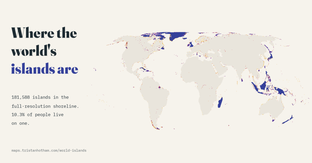
How many islands are there in the world? I counted every one in a detailed, free map of the world’s shorelines and found 181,588, from Greenland down to rocks smaller than a tennis court. Then I asked who owns them, and how many of us live on one. The answer to that last question is 841 million people: one in ten.
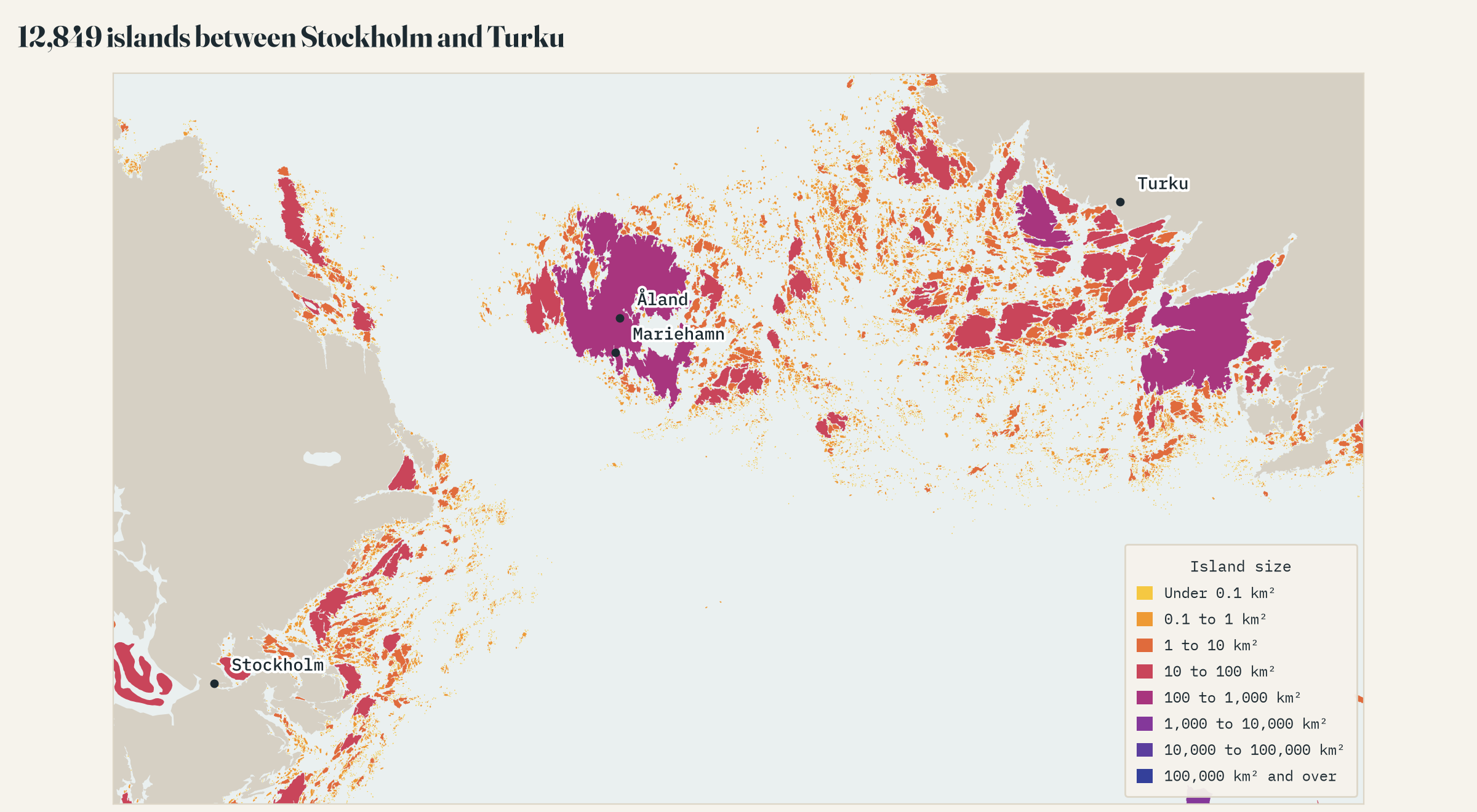
Sweden says it has 267,570 islands. Norway and Finland have their own big numbers, and Indonesia has spent years recounting its archipelago. I have always been a little suspicious of these figures, not because anyone is fibbing, but because the number of islands is not really a fact about the world. It is a fact about the map. Look closer and the coast breaks up into more and more rocks, skerries and sandbanks, each of which is, technically, an island.
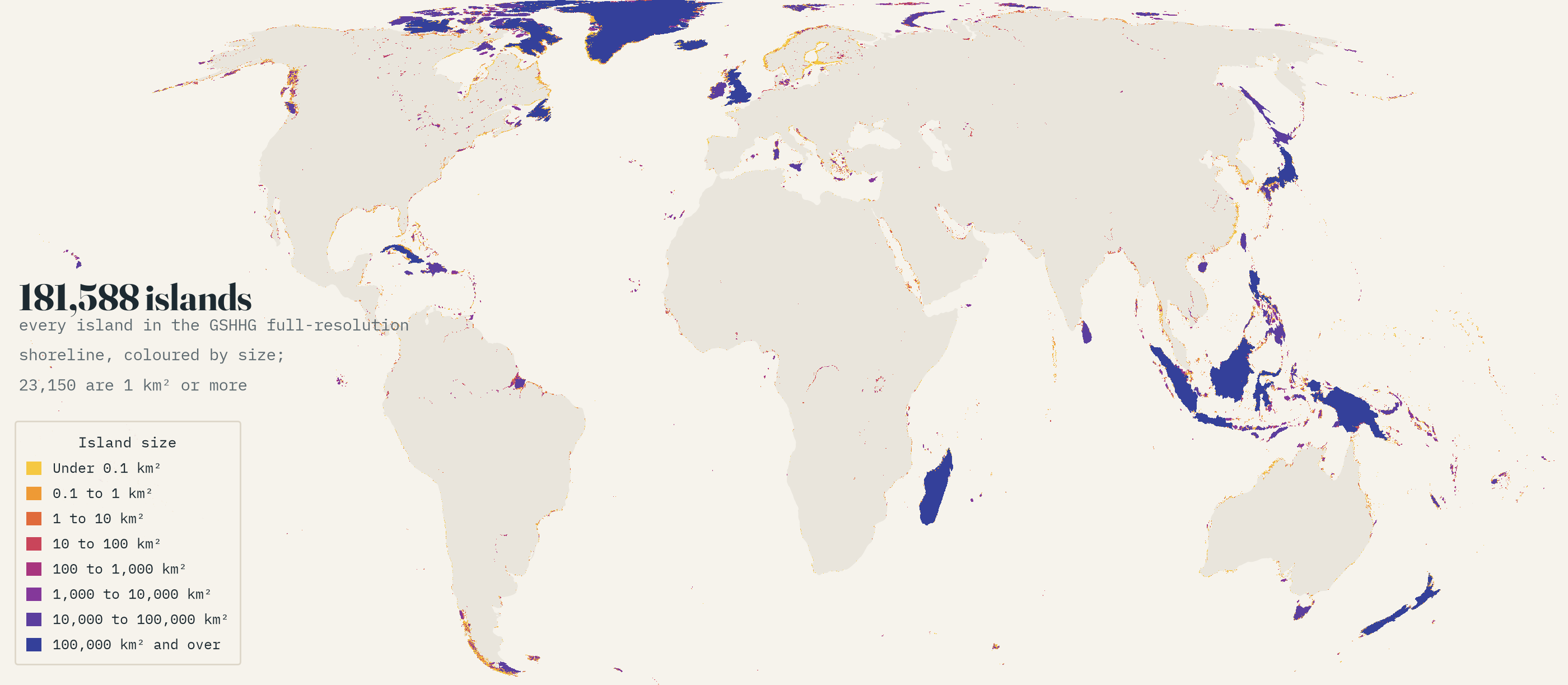
So instead of hunting for the true number, I took one map and counted everything on it. GSHHG is a free world shoreline built by two geophysicists, Paul Wessel and Walter Smith, and used inside a great many mapping tools. At full resolution it draws 181,588 islands: 179,823 in the sea, 1,437 in lakes and rivers and 328 around Antarctica. I gave each a size, a country and a population, using WorldPop’s estimates for 2025, which spread the world’s people over a grid of one-kilometre squares.
Mostly rocks
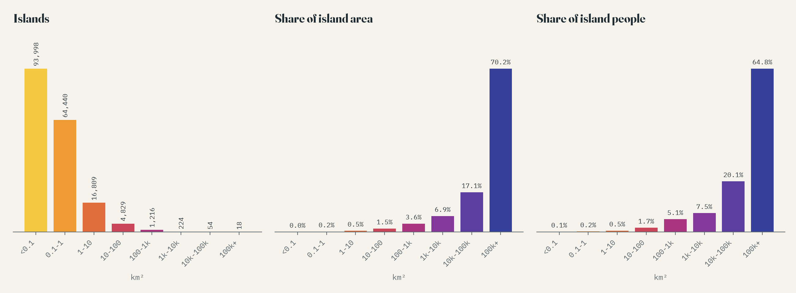
More than half of the islands, 93,998 of them, are under 0.1 km², and between them they hold almost none of the island land. 23,150 islands are a square kilometre or more, 296 are 1,000 km² or more, and only 18 are bigger than 100,000 km², from Greenland down to Iceland. Greenland alone is 21% of all the island land in the world.
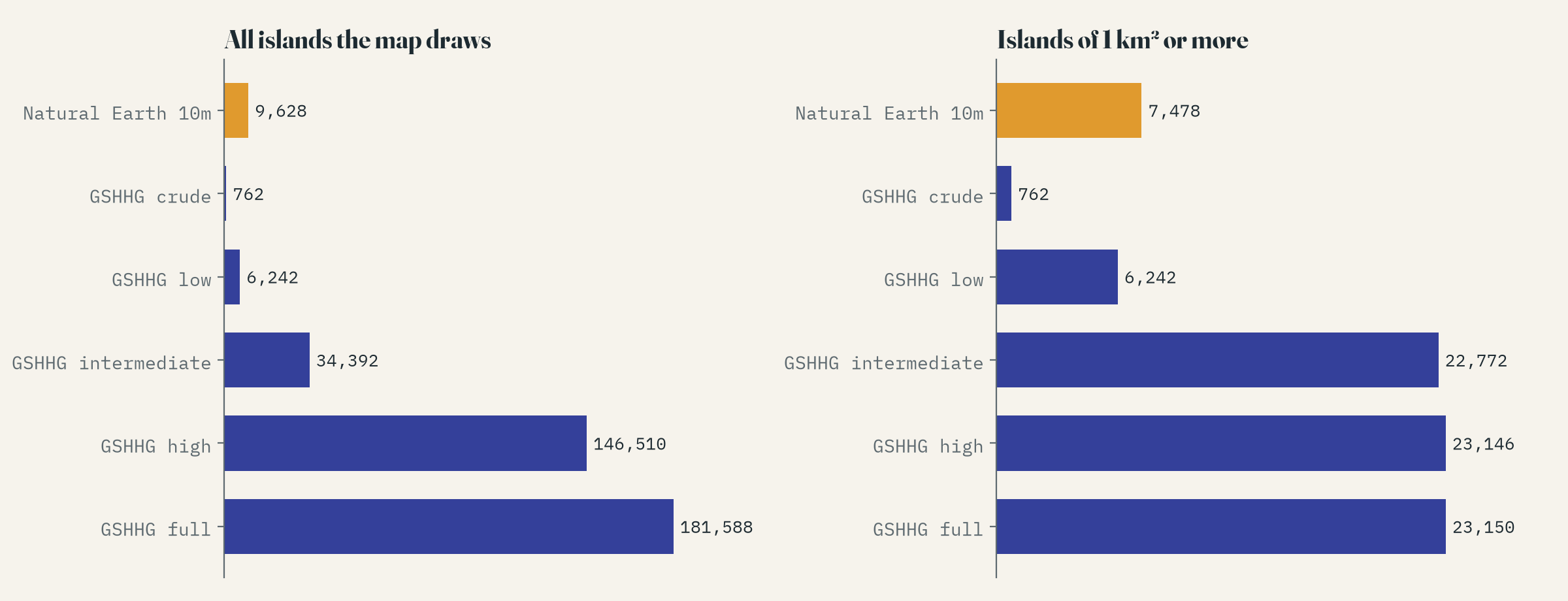
And the small ones are exactly the ones a map cannot agree on. GSHHG comes in five resolutions. The crudest shows 762 islands; the full one 181,588. Natural Earth’s detailed world map, behind countless atlases and apps, has 9,628. But count only islands of a square kilometre or more and the three finest versions agree to within a few hundred: 22,772, 23,146, 23,150. That is the number I would trust.
Canada wins, whatever you count
Canada has the most islands on every measure: 29,249 in all, and 4,048 of a square kilometre or more. Counting every rock, Greenland, Finland, the United States, Norway and Sweden come next, all places where the ice ground the coast into skerries. Counting only islands of 1 km² or more, it is the United States, Indonesia, Russia and Chile. In this shoreline Sweden has 10,036 islands, a long way short of its official figure, which comes from a much more detailed national map. The gap is the whole story of island counting in one number.
One person in ten
Of the 8,188 million people in WorldPop’s grid, 841 million live on islands, 10.3%. That surprised me: I would have guessed lower. Three islands do most of the work. Java has 153 million people, one in every 53 people on Earth and more than all of Europe’s islands put together, Britain included. Honshu has 100 million and Great Britain 67 million. Then come Luzon, Sumatra, Madagascar, Mindanao, Borneo, Hispaniola, Sri Lanka and Taiwan.
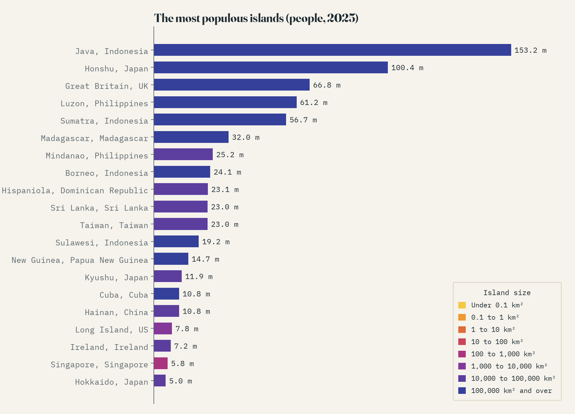
Java alone holds more people than all of Europe’s islands, Great Britain included.
Some countries are split between island and mainland in interesting ways. In Denmark, 56% of people live on islands, mostly on Zealand around Copenhagen and on Funen. In Hong Kong it is 25%, in Malaysia 21%, in Greece 16%, and in Canada 11%, mostly thanks to Montreal, which is an island too.
Crowded and empty
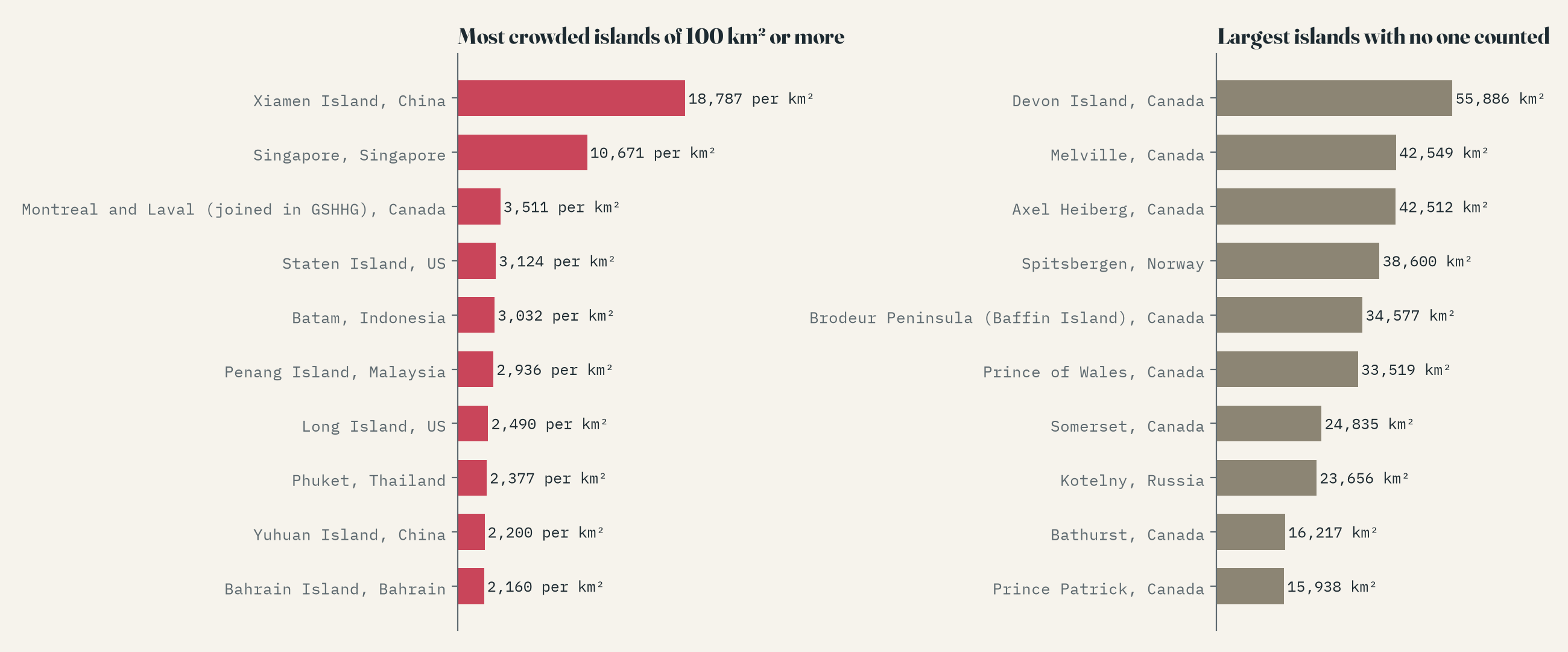
Among islands of 100 km² or more, the most crowded is Xiamen Island in China, with 18,787 people per square kilometre, ahead of Singapore. Among the big ones, over 1,000 km², it is Long Island in New York, then Java. At the other end, 77 islands of 1,000 km² or more have nobody on them in the population grid. The largest is Devon Island in the Canadian Arctic, 55,886 km² of polar desert where NASA tests Mars rovers. Spitsbergen also shows up as empty, which it is not: Longyearbyen has a few thousand people. That is the population model missing a small town, a useful reminder that these are estimates.
An island in a lake on an island
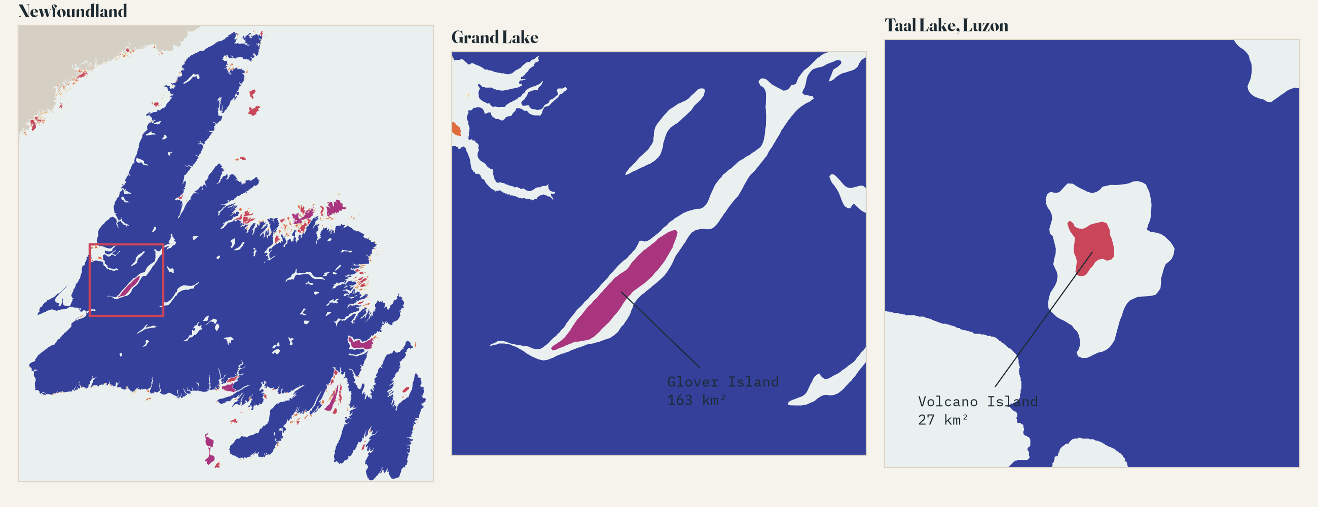
My favourite part of GSHHG is that it knows what sits inside what. 662 of its lakes lie on islands, and 23 islands sit in those lakes. The biggest island in a lake on an island is Glover Island, 163 km² of forest in Grand Lake on Newfoundland. On Luzon there are two: Talim Island in Laguna de Bay, and Volcano Island in Taal Lake, which has its own crater lake with an islet in it, one level deeper than the shoreline goes. Samosir in Lake Toba, which usually gets the title, is joined to the shore by a thin neck of land, so here it does not count.
What the map decides
A shoreline is full of judgements. GSHHG joins Manhattan and Mumbai’s Salsette Island to the mainland, so their millions count as continental. It draws Montreal and Laval as one island, splits a peninsula off Baffin Island, and leaves out Nettilling Lake, the biggest lake on Baffin, along with most of the islands in Finland’s lakes. The population grid is a model, too, and a one-kilometre square cannot split a city across a narrow channel. None of this changes the big picture, but it does mean I would not argue over the last few thousand islands or the last few million people.
The interactive map lets you search any country and see how many islands it has and how many of its people live on them, zoom from the whole world down to single rocks, and click any island for its size, its rank and its population.
How I did this
I read the full-resolution GSHHG shoreline and treated every piece of land other than the five continents as an island, along with islands in lakes and around Antarctica, and repeated the count for the four coarser resolutions and Natural Earth. Each island took its country from Natural Earth, and big shared islands such as Borneo were measured country by country. For people, I used WorldPop’s 2025 estimate, as re-tiled on GitHub by the world-population-3d project, and gave every populated grid square to the island or continent under it, or to the nearest land for squares on the coast. The paper sets out the method and its limits, and the data and code are on GitHub.
Notes and sources
- GSHHG 2.3, Global Self-consistent, Hierarchical, High-resolution Geography database (Wessel and Smith), all five resolutions, LGPL-3.0.
- WorldPop Global 2, constrained population estimate for 2025 at about 1 km, CC BY 4.0, via the world-population-3d tiles (MIT).
- Natural Earth countries, physical labels, land, minor islands and populated places (public domain).
- Sweden’s island count is from Statistics Sweden (2013). Base map tiles on the interactive page © Esri.
- I wrote the text, with drafting and editing assistance from Claude (Anthropic), which also helped prepare the analysis code. I reviewed and checked all text and results.

