
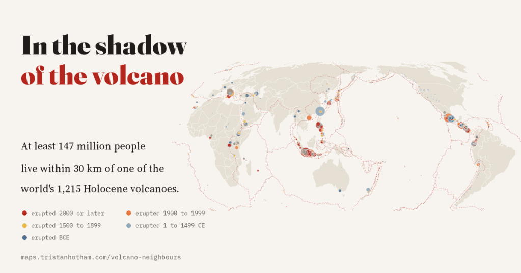
Naples between Vesuvius and Campi Flegrei, Yogyakarta under Merapi, Taipei beside the Tatun volcanoes: I mapped all 1,215 of the world’s Holocene volcanoes and the people living around them. At least 147.5 million of us live within 30 km of one.
We tend to picture volcanoes as remote: a cone on the horizon, a plume seen from a plane. Many are. But volcanoes also make good places to live. Their soils are fertile, their slopes are cooler and wetter than the plains below, and the volcanic arcs of Indonesia, Japan, the Philippines and Central America are the spines of some of the most crowded land on Earth.
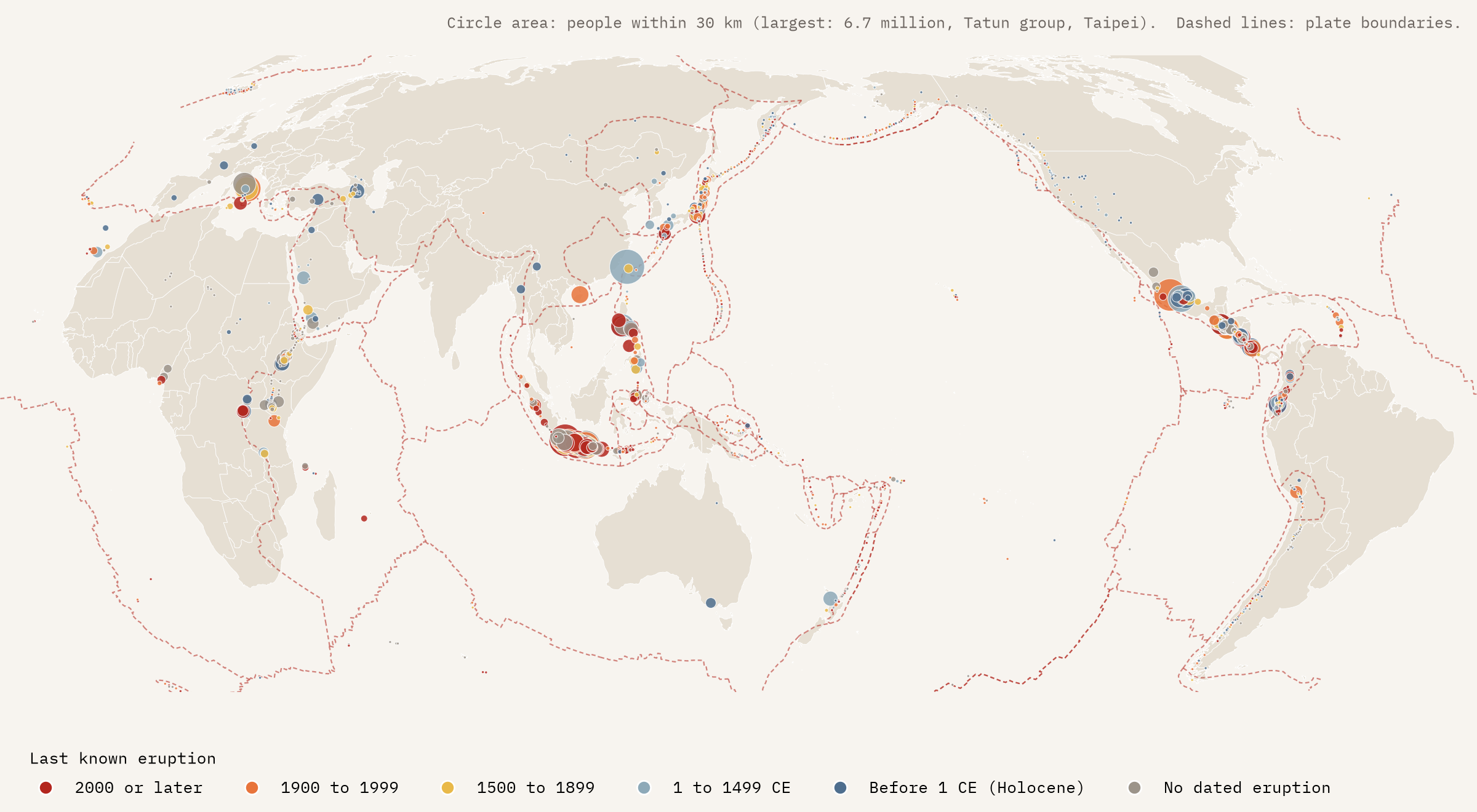
The Smithsonian Institution’s Global Volcanism Program keeps the world’s reference list of volcanoes. Its Holocene list, the volcanoes with signs of activity in roughly the last 12,000 years, has 1,215 entries, and for most of them it gives the number of people living within 5, 10, 30 and 100 km. I put them all on one map, coloured by when each volcano last erupted, where you can click any volcano to draw its rings.
How many people? It depends how you count
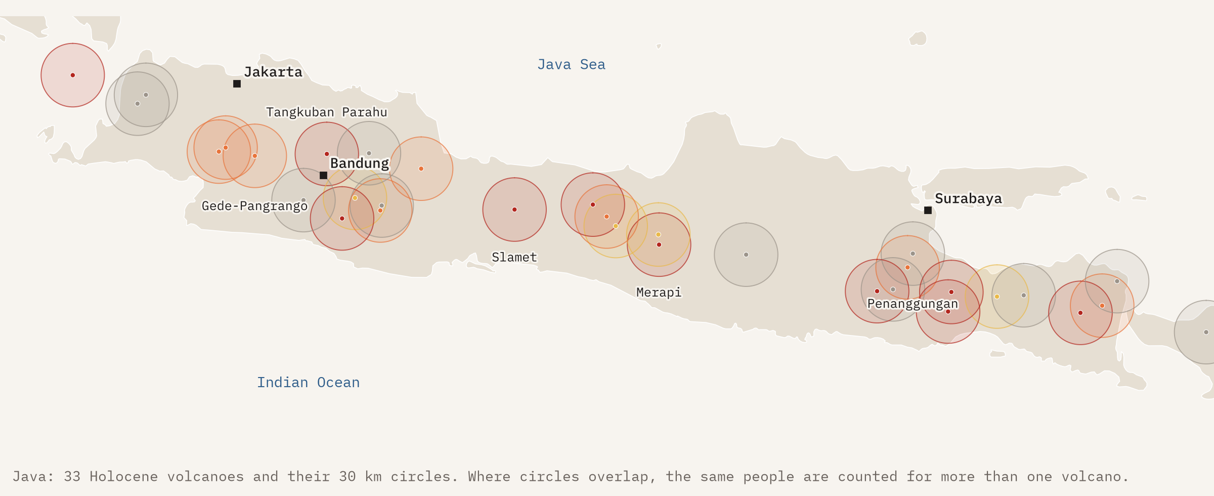
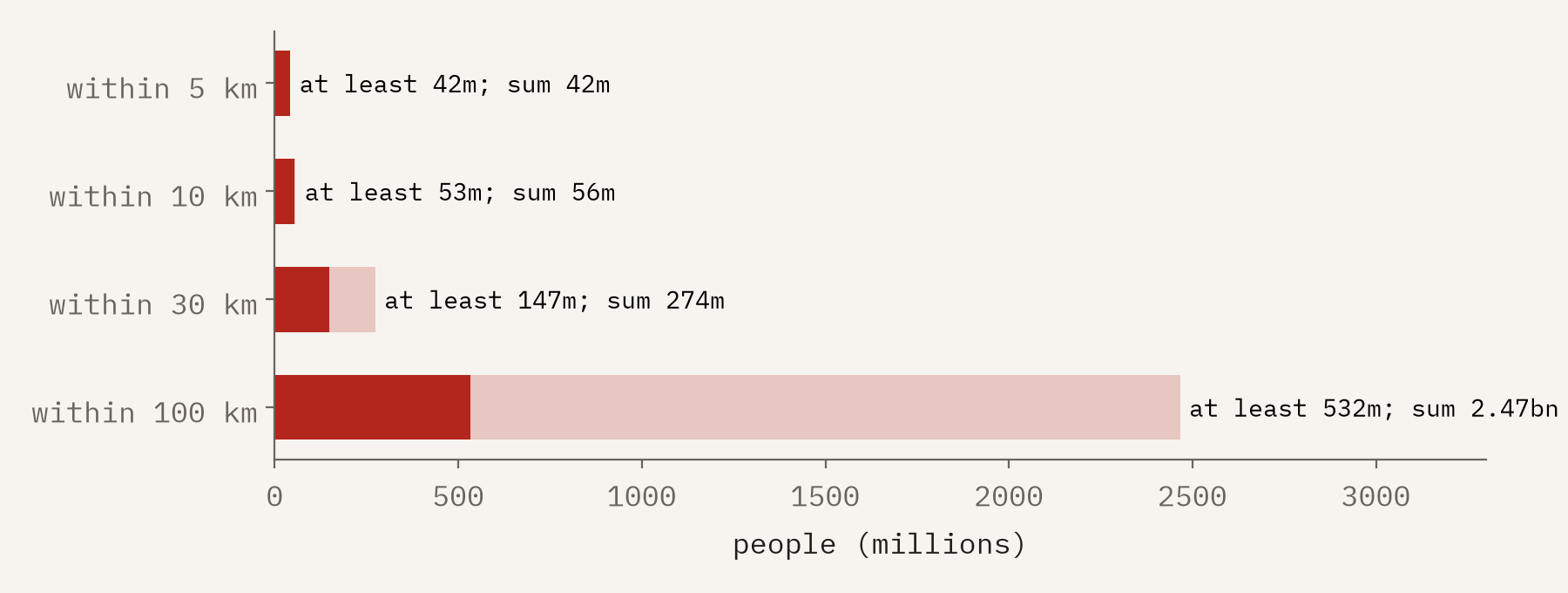
The obvious thing is to add up the figures for every volcano. That gives 56.4 million people within 10 km, 273.5 million within 30 km and 2.5 billion within 100 km. The last number should make you suspicious, and rightly so. People who live near two volcanoes get counted twice, and near ten volcanoes ten times. Vesuvius and Campi Flegrei are only 24 km apart, so most of Naples is within 30 km of both.
So I counted a second way. I took the most crowded volcano, then the next most crowded whose circle does not overlap it, and so on. Circles that do not overlap contain different people, so adding them up gives a number that cannot be too high. The truth sits between the two counts: at least 52.9 million people live within 10 km of a Holocene volcano, at least 147.5 million within 30 km, and at least 532 million within 100 km. Close in, the two counts nearly agree. At 100 km the gap is enormous, and published estimates made with population grids land at around 800 million.
Indonesia, then a long way back
Indonesia has 101 Holocene volcanoes, 40 of them active since 2000, and at least 41.8 million people within 30 km of one: 28% of the world’s total on the cautious count. Mexico comes next (18.7 million), then Japan (10.1 million), the Philippines (9.7 million) and Italy (8.2 million). Taiwan, with just 2 volcanoes, comes sixth, because the Tatun volcanoes rise on the edge of Taipei.
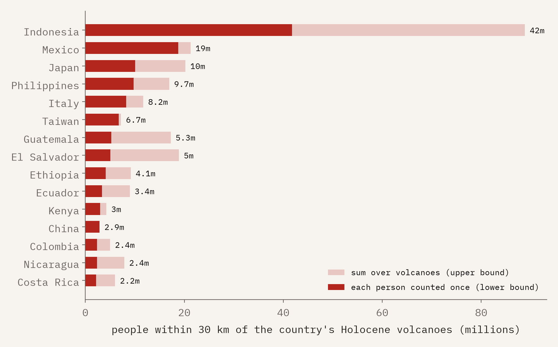
The country with the most volcanoes is the United States, with 165, but most are in Alaska and the Cascades and only about 549,000 Americans live within 30 km of one. Russia, Chile and Iceland are similar: lots of volcanoes, few neighbours. El Salvador and Guatemala are the opposite: small countries built around their volcanoes.
The most crowded volcanoes
The volcano with most people within 30 km is the Tatun Volcanic Group above Taipei (6.7 million), followed by the Michoacán-Guanajuato volcanic field in Mexico, home of Parícutin (5.8 million), Tangkuban Parahu above Bandung (5.7 million), Penanggungan near Surabaya (4.6 million) and Merapi above Yogyakarta (4.3 million). Vesuvius has 3.9 million. Campi Flegrei, the restless caldera under the western half of Naples, has 2.2 million people within just 10 km.
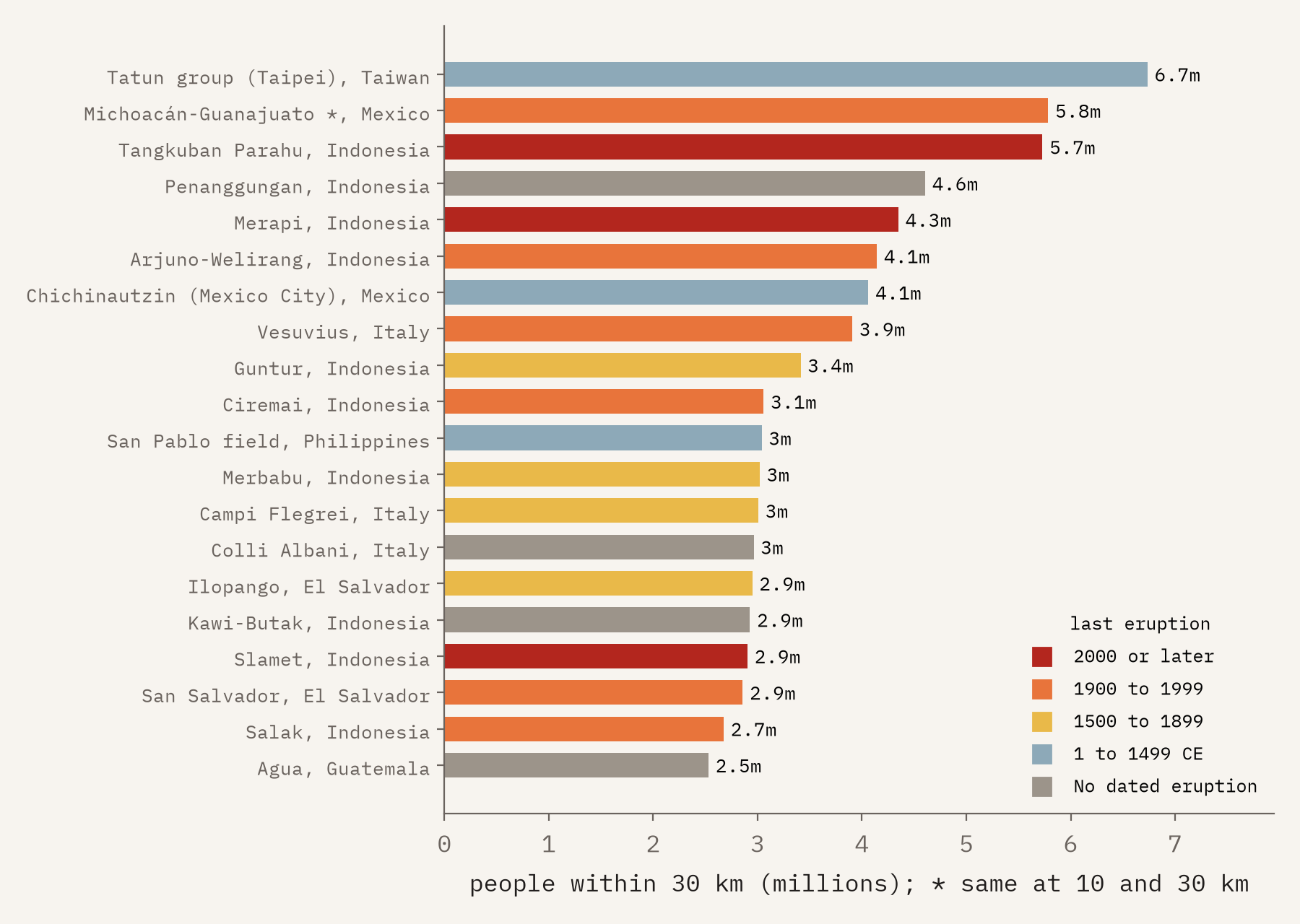
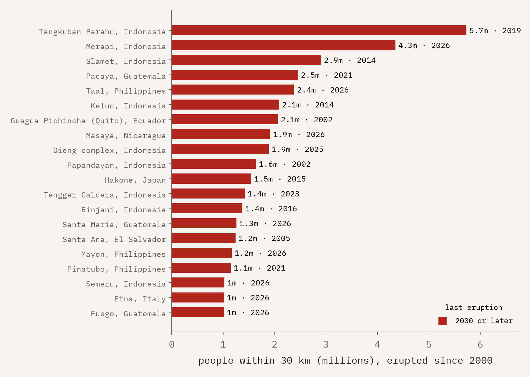
76 volcanoes have a million or more people living within 30 km. 21 of them have erupted since 2000.
Busy and crowded
A crowd matters more around a volcano that is still erupting. 231 volcanoes have erupted since 2000, and at least 84.4 million people live within 30 km of a volcano that has erupted since 1900. The most crowded of the recent ones are Tangkuban Parahu, Merapi, Slamet, Pacaya near Guatemala City and Taal, south of Manila. In the last two years of the list alone, eruptions began at 30 volcanoes, led, in people nearby, by Mayon in the Philippines.
More eruptions, or more people watching?
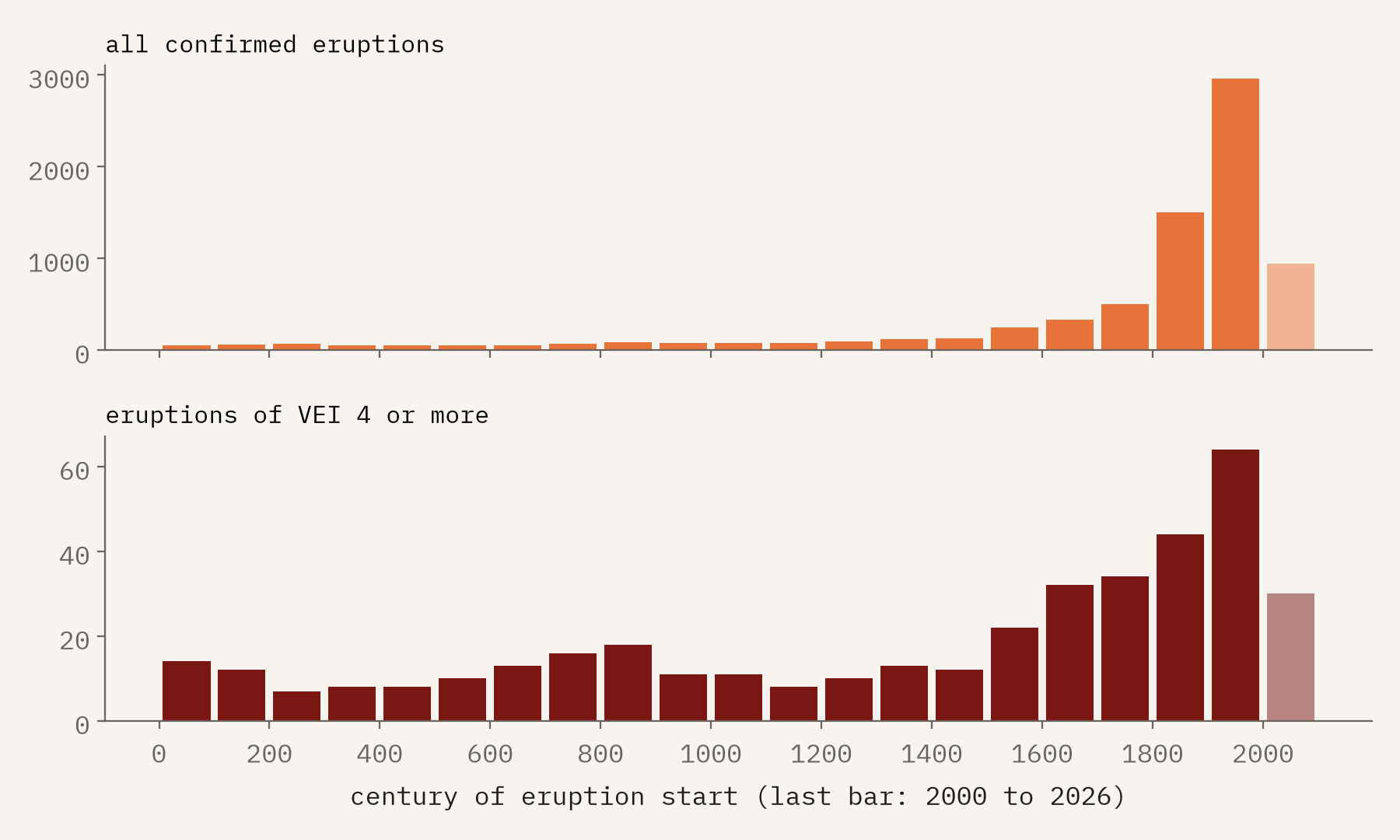
Count the GVP’s 9,918 confirmed eruptions by century and you get a hockey stick: 337 in the 1600s, 1,502 in the 1800s, 2,957 in the 1900s. That is not the Earth getting angrier. Most eruptions in the list (64%) are dated because somebody saw them, and small eruptions on remote volcanoes went unseen for most of history. Big explosive eruptions leave deposits geologists can date long afterwards, and their record is much flatter: eruptions of VEI 4 or more rose only 2.0 times from the 1600s to the 1900s, against 8.8 times for all eruptions.
Being close to a volcano is not the same as being at risk, and the death toll shows how unevenly risk falls. NOAA’s database of significant eruptions records 286,065 deaths in 442 eruptions, led by Tambora in 1815, Krakatau in 1883 and Mont Pelée in 1902. Tambora has only 89,006 people within 30 km today. Ilopango, whose eruption around 450 CE devastated Maya settlements, now has 2.9 million.
How I did this
The volcano list and eruption list are from the Smithsonian’s Volcanoes of the World, version 5.3.5, using exports posted to GitHub whose headers give the version and download date. Current exports no longer include population, so the population figures come from version 5.1.7 of the same list, matched by volcano number. They are the GVP’s own figures and a fixed snapshot, unchanged since at least 2020, so they will understate today’s populations in fast-growing places, and the export does not say which year they describe. For a few large volcanic fields the figure is the same at every distance, which suggests it covers the whole field. The lower bound comes from non-overlapping circles, as described above, and a volcano on a border counts for both countries. Distances are not hazard zones: what an eruption reaches depends on its size, the wind and the valleys. The paper sets out every step, and the data and code are free to reuse for non-commercial purposes, as the Smithsonian’s terms require.
Notes and sources
- Global Volcanism Program, 2025. Volcanoes of the World (v. 5.3.5). Distributed by Smithsonian Institution, compiled by Venzke, E. https://volcano.si.edu/ (accessed via the named GitHub mirrors). Volcano and eruption lists.
- Global Volcanism Program, 2024. Volcanoes of the World (v. 5.1.7). Distributed by Smithsonian Institution, compiled by Venzke, E. https://volcano.si.edu/ (accessed via the named GitHub mirrors). Population within 5, 10, 30 and 100 km. GVP data are used under the Smithsonian’s terms of use; this work is not endorsed by the Smithsonian.
- NOAA National Centers for Environmental Information, Global Significant Volcanic Eruptions Database, doi:10.7289/V5JW8BSH (public domain).
- Bird P (2003) An updated digital model of plate boundaries. Geochemistry, Geophysics, Geosystems 4(3), 1027; GeoJSON by Hugo Ahlenius, Nordpil (ODC-By 1.0). Natural Earth outlines and places (public domain).
- Brown SK, Auker MR, Sparks RSJ (2015) Populations around Holocene volcanoes and development of a Population Exposure Index. In Loughlin SC, Sparks RSJ, Brown SK, Jenkins SF, Vye-Brown C (eds) Global Volcanic Hazards and Risk. Cambridge University Press, 223 to 232. The source of the figure of about 800 million people within 100 km.
- I wrote the text, with drafting and editing assistance from Claude (Anthropic), which also helped prepare the analysis code. I reviewed and checked all text and results.

