
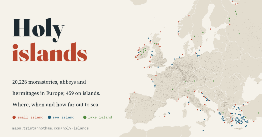
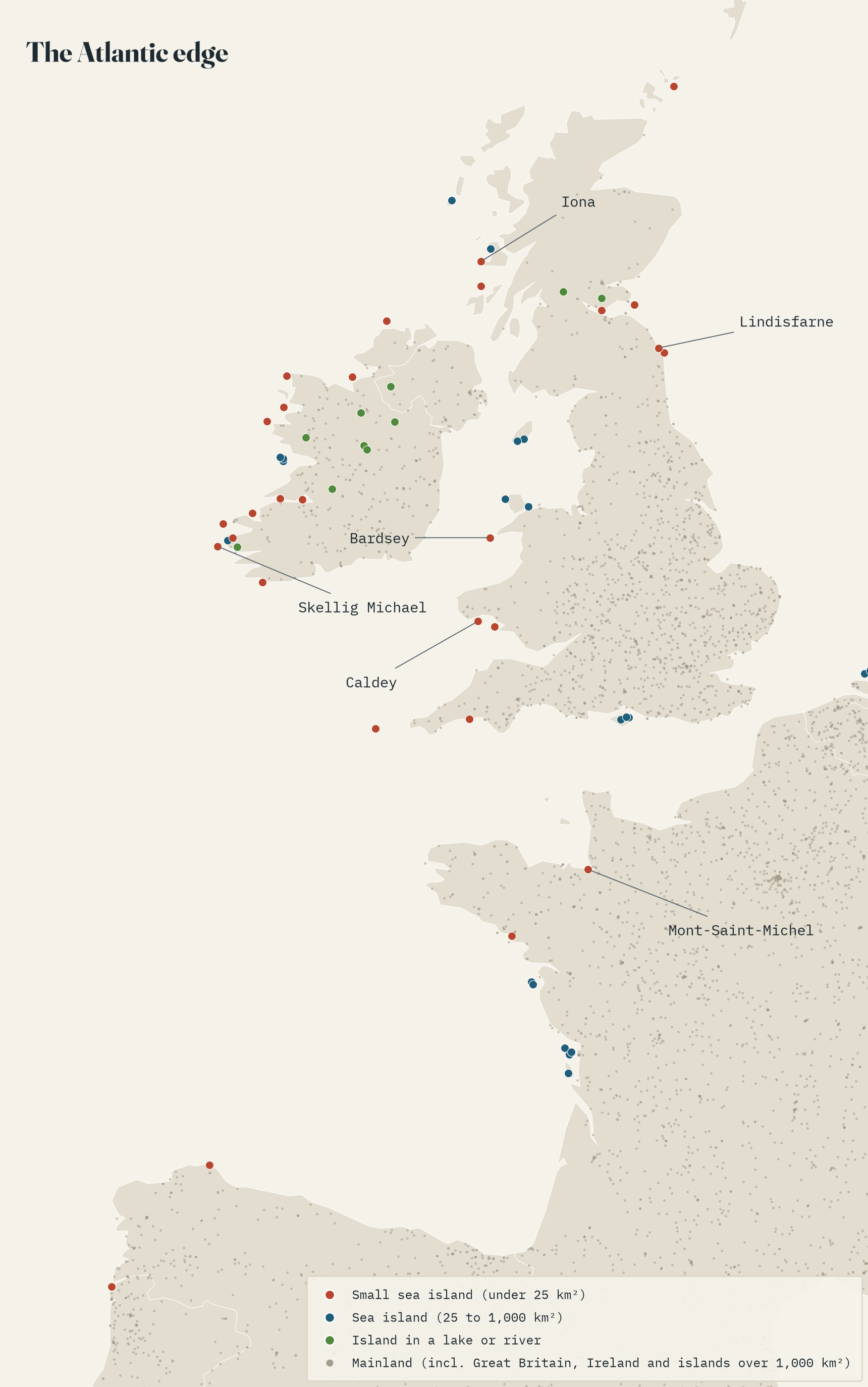
Skellig Michael, Iona, Lindisfarne, Bardsey: the early monks of Britain and Ireland are famous for going to sea. I checked 20,228 monasteries, abbeys and hermitages across Europe against a detailed shoreline to see how unusual that really was. Before 800, 4.3% of dated houses stood on islands. After 1100, about one in a hundred.
There is a rock twelve kilometres off the coast of Kerry where, some time around the seventh century, monks built stone beehive huts on narrow ledges six hundred feet above the Atlantic. Skellig Michael is the extreme case of something Irish and British monks did again and again: they went looking for a ‘desert in the ocean’, and found it on Iona, Lindisfarne, Bardsey, Caldey and a hundred smaller islands. Some went as far as the Faroes and Iceland.
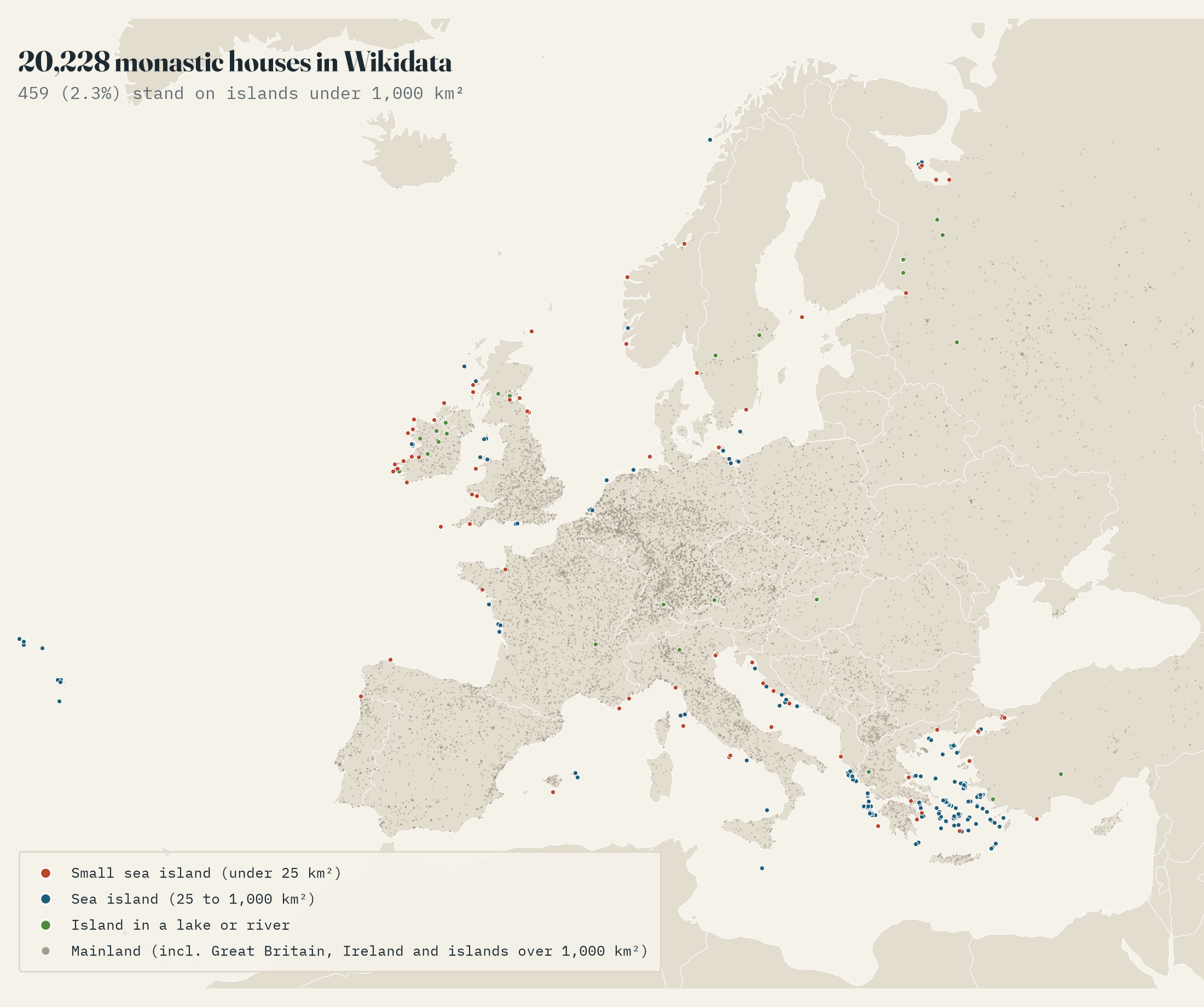
It is a lovely story, but is it a pattern or just a handful of famous places? Wikidata, the open database behind Wikipedia, records 20,228 monastic houses in Europe with a location. I put every one of them on GSHHG, a very detailed world shoreline that includes islets as small as Skellig, and asked: is it on an island, how big is the island, and how far is it from the mainland? Great Britain and Ireland are islands too, of course, but for this question I counted them, and any island over 1,000 km², as mainland.
One in forty, but not evenly
Across Europe, 459 houses (2.3%) stand on islands: 414 at sea and 45 on islands in lakes and rivers. That sounds small, until you split it by when the houses were founded. Only 35% have a foundation date, but among those, 11 of the 255 founded before 800 are on islands (4.3%). They are a roll call of the island ideal: Lérins off Cannes and Cabrera off Mallorca, Bardsey, Caldey, Iona, Douglas on Man and Mont-Saint-Michel, and the lake islands of Reichenau, the Chiemsee and the Île Barbe at Lyon. For houses founded between 1100 and 1299, when Cistercians, canons and friars were building all over Europe, the share is 1.1%.
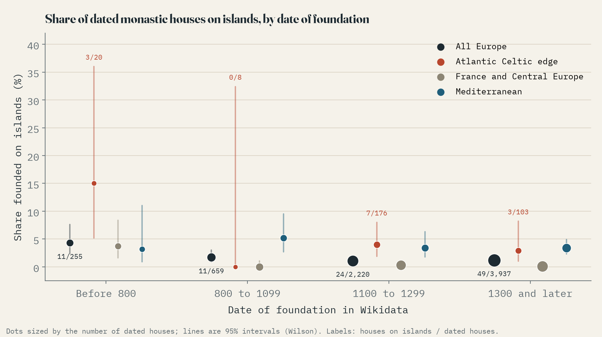
On the Atlantic Celtic edge (Ireland, Scotland, Wales, Brittany and Galicia) the contrast is sharper still. 3 of the 28 dated houses founded there before 1100 are on islands, against 5 of 3,230 houses founded in France and Central Europe from 1100 on (0.2%). The early Atlantic sample is tiny, so I would not lean on the exact figure, but the direction is not in doubt.
Scotland, Wales and the Aegean
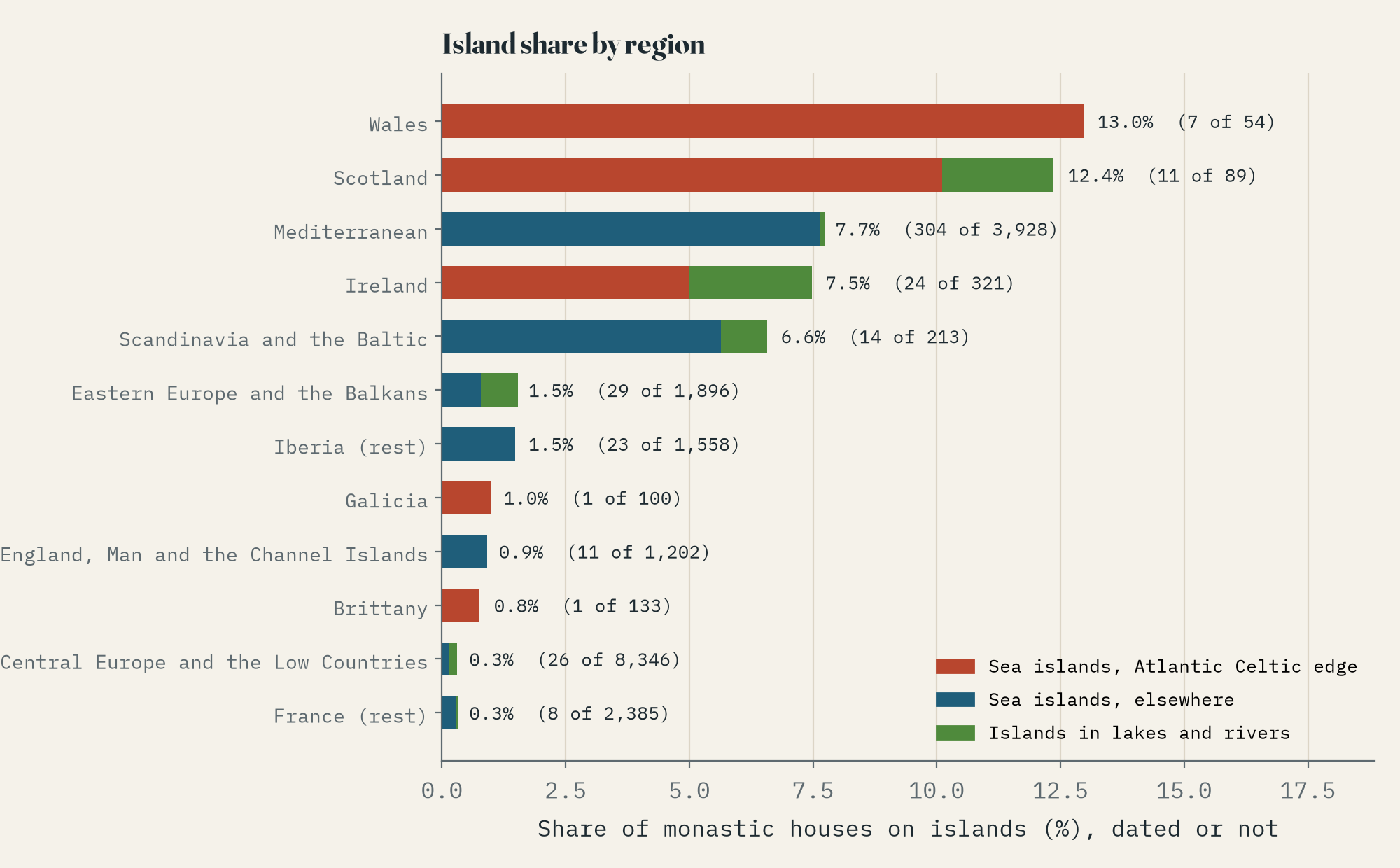
Counting every house, dated or not, Wales (13.0%) and Scotland (12.4%) have the highest share on islands. But the place with the most island monasteries is the Aegean: the Mediterranean has 304, 83% of them on Greek and Turkish islands, from Patmos and Chios to Imbros. There the island monastery was never an early phase. It is a living tradition, carried north in the 1300s and 1400s to Valaam and Konevets on Lake Ladoga and Solovetsky in the White Sea.
Lakes have holy islands too, 45 of them in this data. Ireland is full of them: Inis Cealtra on Lough Derg, Inchcleraun on Lough Ree, Inchagoill on Lough Corrib. Many are too small for the shoreline data, so I checked every house with an island word in its name (Inis, Inch, Ynys, Isle, Île, Insel) by hand.
How far out?
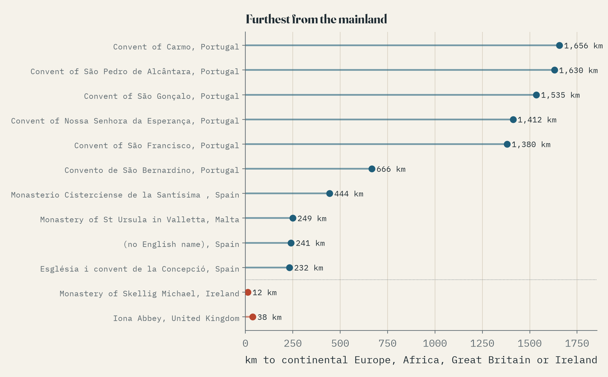
The Celtic holy islands turn out to be close in: Skellig Michael is 12.3 km from the mainland and Iona 38 km. Half of all the sea-island houses are within 24 km. The furthest are much later: the Franciscan and Carmelite convents of the Azores, founded after the Portuguese settled the islands, up to 1,656 km out in the Atlantic. Iceland’s medieval monasteries are further still from the mainland, but Iceland is too big to count as an island here.
Before 800, 4.3% of dated monastic houses stood on islands. After 1100, about one in a hundred.
The ends
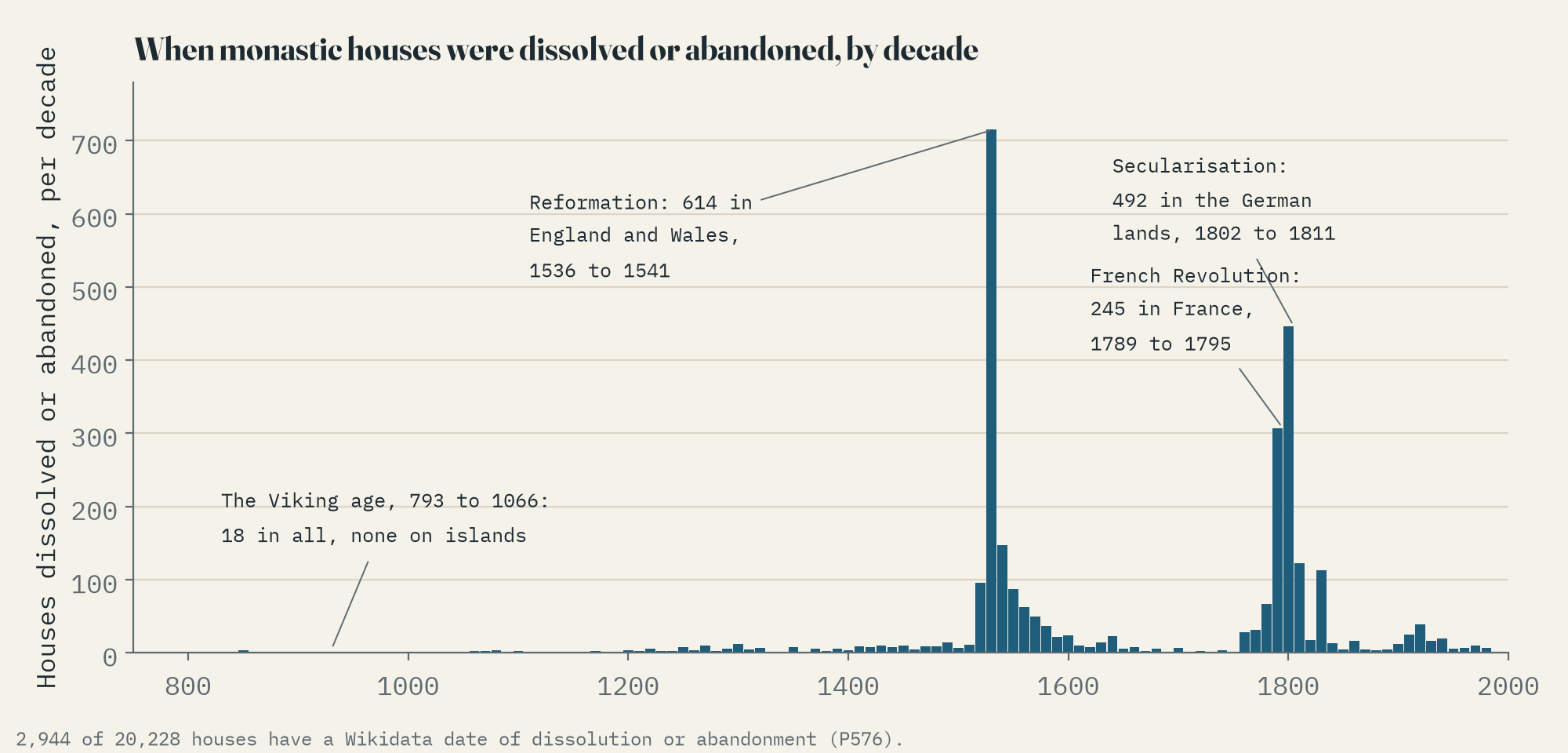
2,944 houses have a date when they were dissolved or abandoned, and the dates come in great waves: 614 in England and Wales between 1536 and 1541, 245 in revolutionary France, 492 in the German secularisations of 1802 to 1811. The Vikings, who sacked Lindisfarne in 793 and Iona two years later, barely appear: 18 closures are dated between 793 and 1066, and none of them on an island. That is the record talking, not history. Wikidata mostly describes houses as they were last refounded, so Lindisfarne Priory is the Benedictine cell of 1093, closed by Henry VIII.
What the map cannot tell you
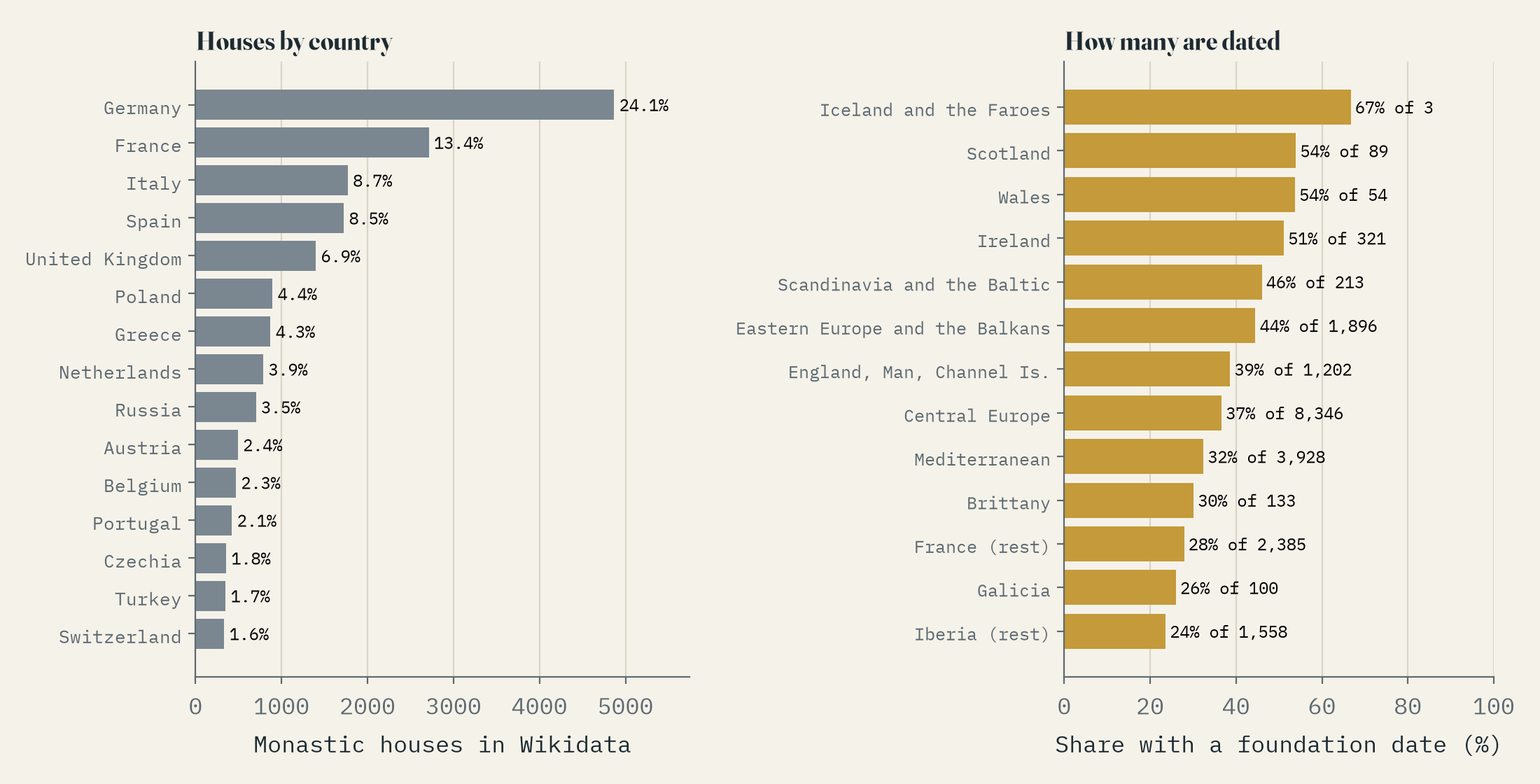
This is a map of Wikidata, and Wikidata’s monasteries are lopsided. Germany has 24% of them. Ireland has 321, a small fraction of its early church sites, many of which are filed as churches or archaeological sites instead. Iceland and the Faroes have 3 houses between them and no papar at all. Only a third of houses have a foundation date, and Skellig Michael is one of those without. So read the shares as a sketch of a pattern, with the honest error bars on the chart.
The interactive map lets you play through the centuries of foundation, keep only the island houses, zoom to the Hebrides, the Aegean or Lake Ladoga, and search for any house or town. Click a dot for its island, its distance from the mainland and its dates.
How I did this
I took every Wikidata item that is a kind of monastery, abbey, priory, hermitage or clochán and has coordinates, through the QLever query service, and kept the 20,228 in Europe (with Iceland, the Faroes, Macaronesia, Cyprus and Turkey). Each point went onto the full-resolution GSHHG shoreline; points just offshore were put on the nearest land within 1.5 km, and houses named after islands were checked by hand. An island is land under 1,000 km². Wikidata stores ‘the 12th century’ as a full date, so round-century dates are read as the middle of the century, and I tested the other reading too. The paper sets out the method and its limits, and the data and code are on GitHub.
If a monastery near you is missing, undated or on the wrong side of the water, Wikidata is open for anyone to fix.
Notes and sources
- Wikidata, monastic houses with coordinates, inception, dissolution, country and sitelinks, via QLever. CC0.
- GSHHG full-resolution shorelines (Wessel and Smith), LGPL-3.0.
- Natural Earth countries, provinces and populated places (public domain).
- Base map tiles on the interactive page © Esri.
- I wrote the text, with drafting and editing assistance from Claude (Anthropic), which also helped prepare the analysis code. I reviewed and checked all text and results.

