
Hundreds of hills and woods in Britain are still named after the gallows. I measured 340 of them for height, roads, towns, views and boundaries, and compared each with fifty ordinary places nearby, to see where Britain really put its execution places.
The gallows have gone, but the names have not. Open the Ordnance Survey’s gazetteer of Great Britain and you find 296 places called Gallows or Gallow something, from plain Gallows Hill to Gallowstree Common and Gallows Knowe, and another 44 called Gibbet. Most of them, 67%, are hills.
There is a familiar picture of where execution places stood: on a rise, beside the main road, just outside the town but in full view of it, perhaps on the boundary, at the edge of the community. In my last post, Bloody Place Names, I asked whether grim names mark real battles. This time I left battles aside and asked something simpler. How much of that familiar picture can the map itself confirm?
Two countries, two words
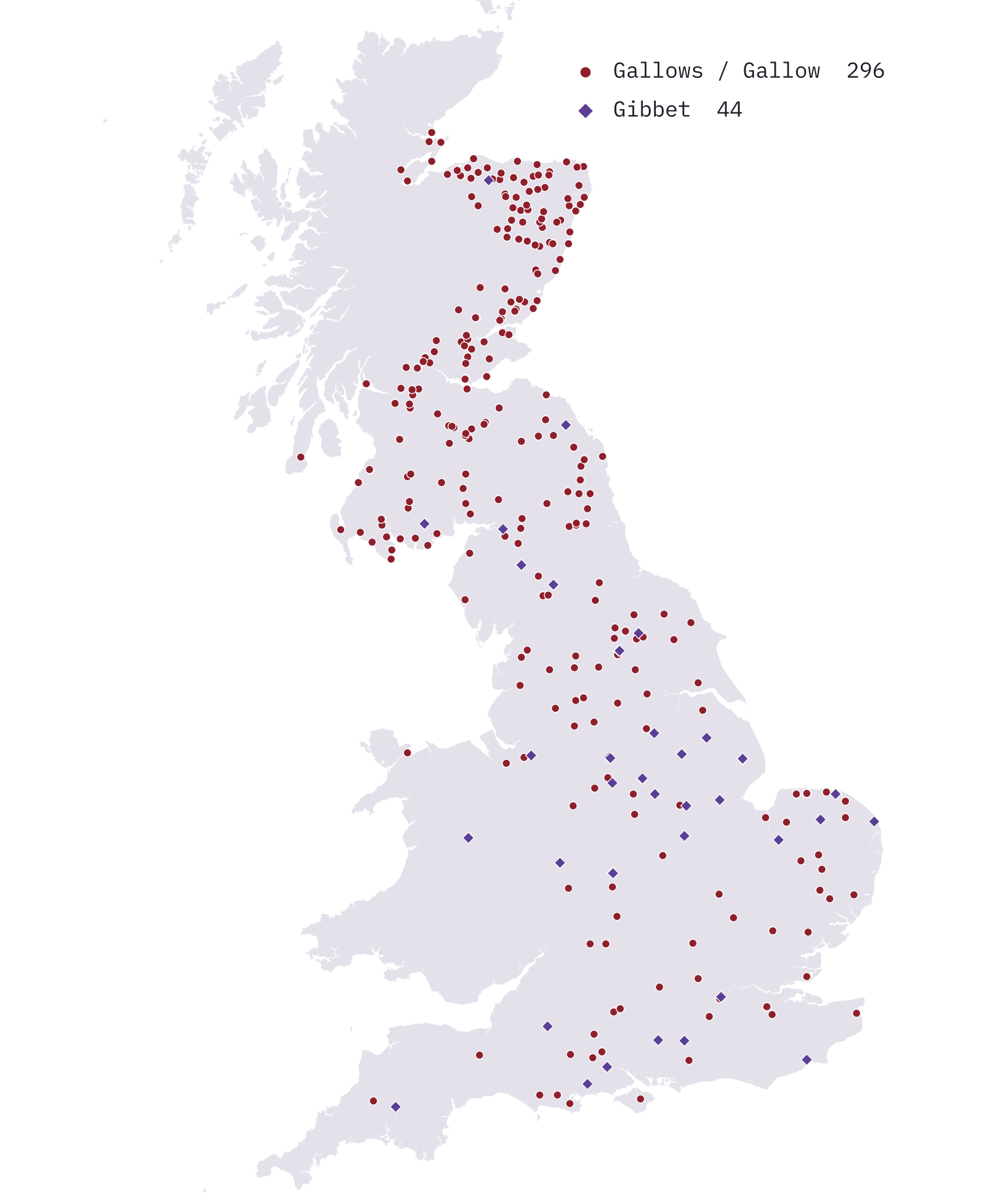
The first surprise is how Scottish the names are. Scotland has 184 of them, England 154 and Wales just two. The Scots form is Gallow Hill: 85 of the 103 on the map are in Scotland, with Aberdeenshire alone holding 47 names. In England it is Gallows Hill and, more often than anywhere else, Gibbet Hill. I cannot tell from the map why Wales has so few.
To make the test fair, I compared each name with fifty ordinary names of the same kind (hills with hills, woods with woods) drawn at random from the same 50 km square, and with fifty random points of land. Then I asked whether the gallows names differ from those stand-ins, using 2,000 replicate draws.
Near the town, but not in it
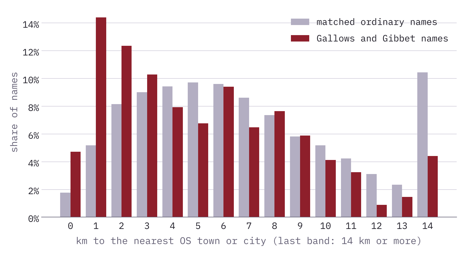
The clearest result is distance to a town. 31% of Gallows and Gibbet names lie within 3 km of a place the OS calls a town or city. Of the matched ordinary names, 15% do. That is roughly twice as many, and not one of the 2,000 replicate draws came close.
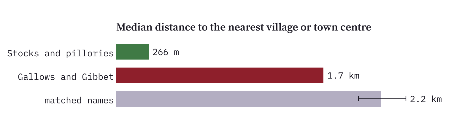
But they are rarely in the settlement itself. Village stocks and pillories, the punishments meant to sit in the middle of things, show the difference. The 89 mapped in OpenStreetMap stand a median 266 m from a village centre. The gallows names sit a median 1.7 km away: out of the village, but not far.
Beside the road out of town
The second strong result is roads. 29% of the names lie within 500 m of a modern A-road, against 17% of matched names. You might think that is just because A-roads run out of towns, so I repeated the test with controls that are just as close to a town. The gap barely closes: those controls reach 19%. Gibbets are the most roadside of all, with 41% within 500 m. In England, 21% of the names lie within 1 km of a Roman road, against 13% of matched names.
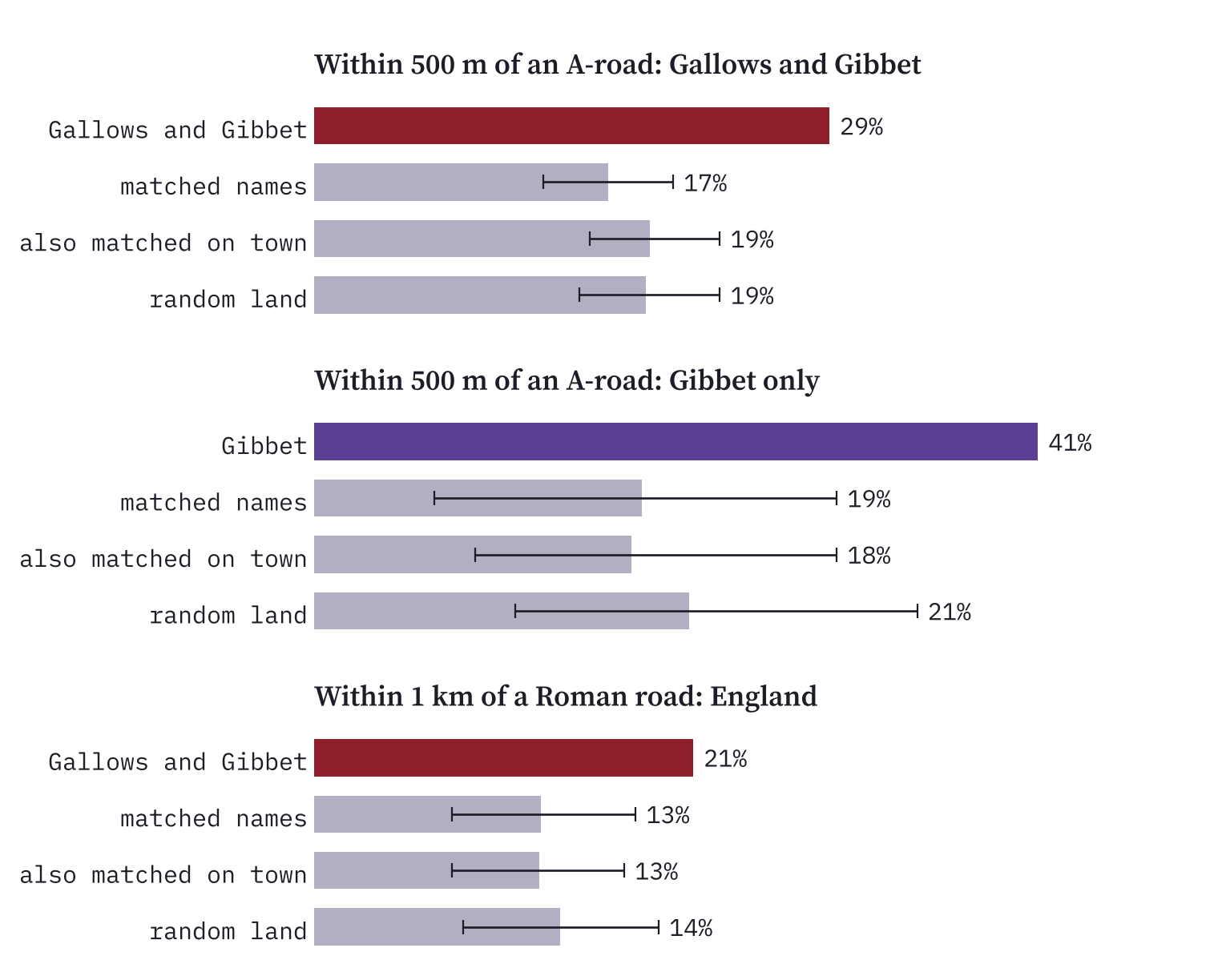
One of the few gibbets with a Wikidata entry makes the point neatly. Caxton Gibbet in Cambridgeshire sits 14 m from an A-road and 9 m from the line of a Roman road in the Itiner-e atlas.
A hill, but a low one
Are they on hilltops? Yes and no. 72% stand higher than the average ground within 1 km, against 47% of random points of land. But any named hill would do that. Compared with other named hills nearby, Gallows hills are actually less prominent: a median rise of 7 m above their surroundings, against 15 m. That gap is mostly Scottish; in England the gallows names are about as prominent as their neighbours.
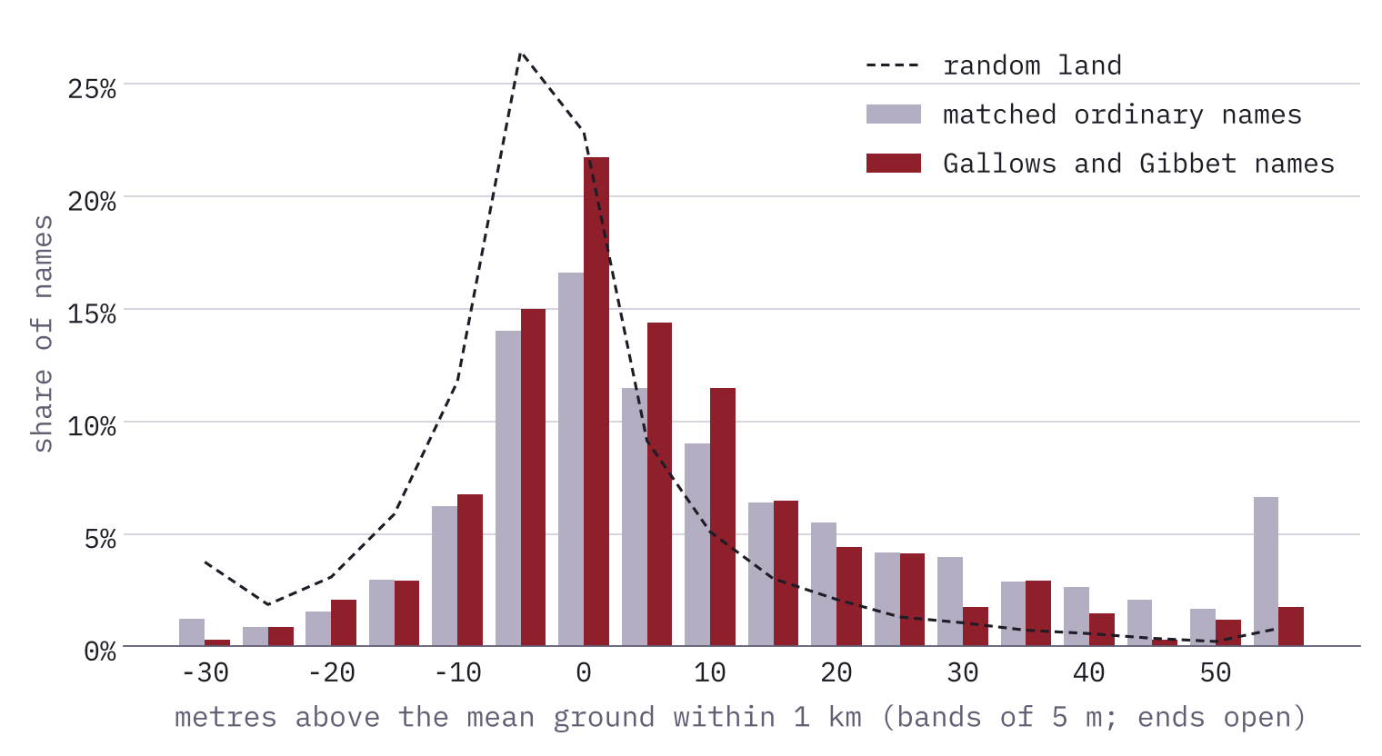
The gallows went on the first rise outside town, not on the highest hill in the district.
In view, mostly because they are close
Could the town see its gallows? For every name within 10 km of a town I traced a line of sight across the terrain from 2 m above the town’s centre point to 3 m above the name. 36% are in sight, against 29% of matched names. But nearer things are easier to see, and against controls at the same distance from a town the figure is 31%. Being in view looks like a by-product of being close, though the map cannot say which came first in anyone’s mind.
On the boundary? Only faintly
The boundary idea is the one I most wanted to confirm, and the one the data supports least. I have no map of medieval parish boundaries, so I drew rough hundred boundaries halfway between Domesday places in different hundreds. In England, 25% of the names lie within 500 m of one of these edges, against 19% of matched names: the right direction, but a gap that luck produces in 10% of draws. Modern district and county boundaries show nothing.
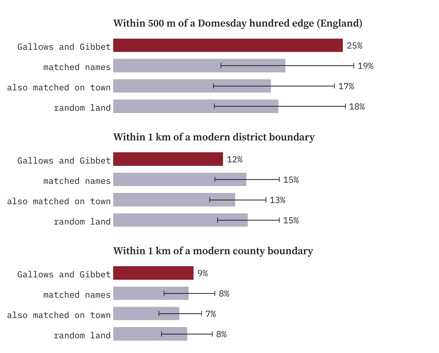
That is not proof that gallows avoided boundaries. A boundary drawn between two village points can be a kilometre out, and that blur would hide a real pattern. It means only that this map, at this resolution, cannot show it.
A word of warning about Hanging
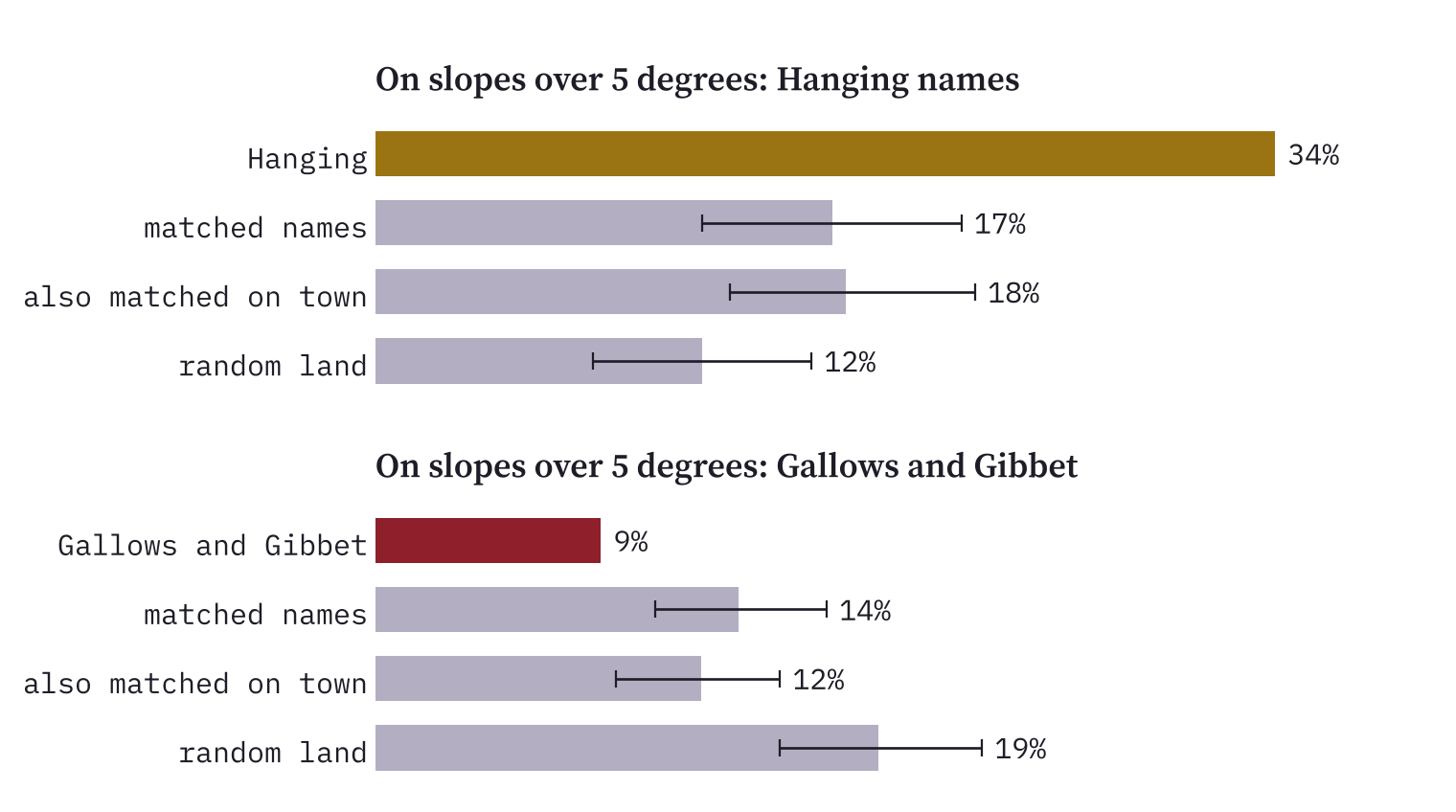
Not every grim-looking name is grim. “Hanging” in a place name often describes a steep slope, as in a hanging wood, and there are 194 Hanging names on the map. They make a good test of the method, and they pass it: 34% sit on slopes over 5 degrees, against 17% of matched names, and they show none of the town or road pattern. Gallows names are the opposite: only 9% are that steep. The 37 Hangman names behave like ordinary names, so I draw no conclusion from them.
How I did this
I searched all 267,744 named natural and settlement features in OS Open Names for “gallow” (leaving out Galloway), “gibbet”, “hangman” and “hanging”. Heights come from AWS Terrain Tiles, with cells of about 100 m; lines of sight use the same code as my Within Sight study of hillforts. Towns and villages are OS Open Names places; roads are OpenStreetMap A-roads and the Itiner-e Roman roads; boundaries are ONS districts and counties and approximate edges between Domesday hundreds. Every comparison uses fifty matched names, fifty random land points and 2,000 replicate draws.
The caveats matter. An OS point is a label for a hill or wood, not the spot where a gallows stood. Today’s towns and A-roads only stand in for medieval ones, and many gallows belonged to manors or baronies rather than towns. OS Open Names leaves out field names, where many execution places will be remembered. And I tested 26 measures, so a single borderline result should be taken lightly. The town and road results are not borderline.
Notes and sources
- Place names: OS Open Names. Contains OS data © Crown copyright and database right 2026, Open Government Licence v3.0.
- Elevation: AWS Terrain Tiles (Mapzen/Tilezen).
- Roman roads: Itiner-e, de Soto, Pažout, Brughmans and others (2025), CC BY 4.0, datum corrected as in How Roman Is Your Road.
- A-roads, stocks and pillories: © OpenStreetMap contributors, ODbL. Gallows items: Wikidata, CC0.
- District and county boundaries: Office for National Statistics, Open Government Licence v3.0. Domesday places and hundreds: Hull Domesday Project (J.J.N. Palmer, George Slater and the University of Hull, CC BY-NC-SA), via realm-domesday.
- Companion posts: Bloody Place Names and Within Sight.
- Paper, data and code: Zenodo and GitHub.
- I wrote the text, with drafting and editing assistance from Claude (Anthropic), which also helped prepare the analysis code. I reviewed and checked all text and results.

