
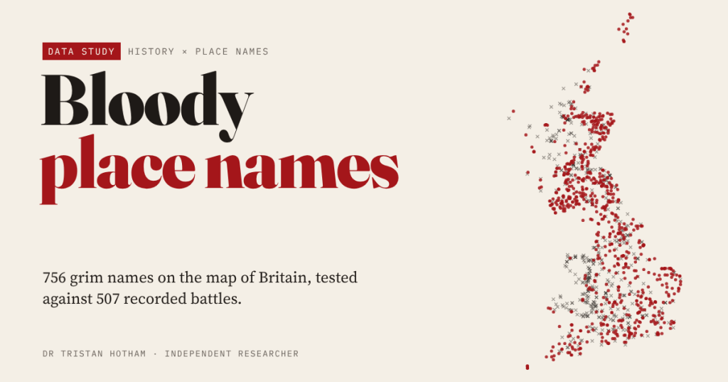
Britain’s map is scattered with Battle, Bloody Meadow, Slaughter, Dead Man’s Hill and Gallows Hill. I measured 756 of these grim names against every recorded battle I could place, to find out which ones remember a fight and which are red herrings.
Drive through Britain with an Ordnance Survey map on your knee and it starts to read like a crime scene. There is a town called Battle. There are Bloody Meadows, a Murder Cleugh, dozens of Dead Man’s this and that, and more than three hundred names built on Gallows or Gallow. In the Cotswolds you can visit Upper and Lower Slaughter. It is hard not to imagine every one of them as a memory of blood spilled on that very spot.
So I tested it. I searched all 267,744 named hills, woods, valleys, waters and settlements in OS Open Names for twelve grim words and found 756 names. Then I measured how far each one lies from the nearest of 507 battles and sieges in Great Britain that have a location in Wikidata. The short answer: only 42 of the 756 lie within 2 km of a recorded battle, and 58% are more than 10 km from any.
A map of grim names
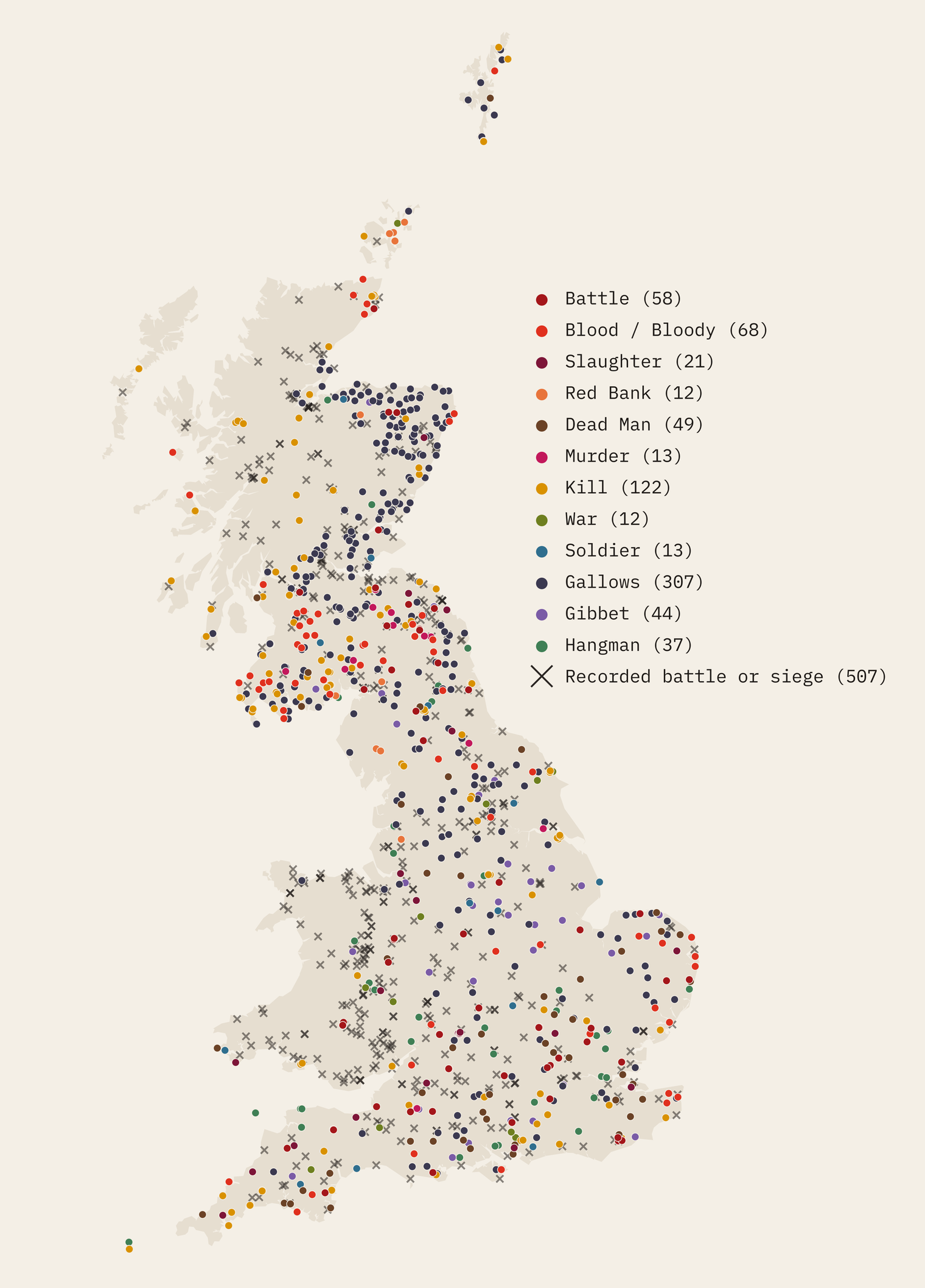
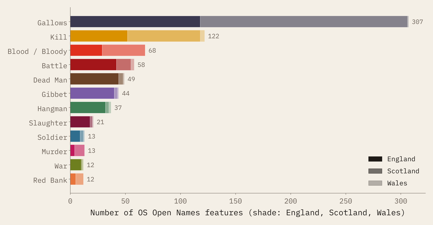
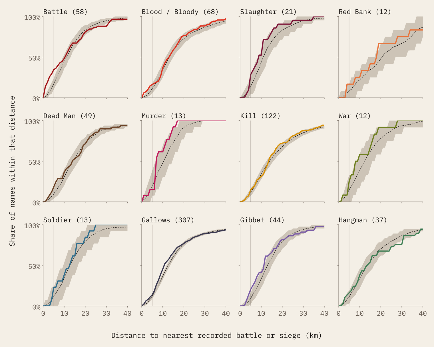
Gallows dominates, with 307 names, 212 of them hills, and 188 of them in Scotland, with a striking cluster in Aberdeenshire. Kill comes next with 122, more than half of them in Scotland. Then Blood (68), Battle (58), Dead Man (49) and a long tail of Gibbets, Hangmen, Slaughters, Soldiers, Murders, Wars and Red Banks. A match only means the name contains the letters. It says nothing about what the name means.
A fair test
Counting names near battles is not enough, because almost everything is near something. Battles were fought along roads, at river crossings and around towns, which is exactly where the map is thickest with names. A Gallows Hill outside a county town will often be a few miles from a siege of that town, whatever the name means.
So every grim name got a set of stand-ins: ordinary OS names of exactly the same type (a hill for a hill, a wood for a wood) from the same 50 km square, drawn at random 2,000 times. These fake sets have the same geography as the real names but nothing grim about them. If the real names sit closer to battles than the stand-ins, the closeness is about the names.
Battle keeps its word
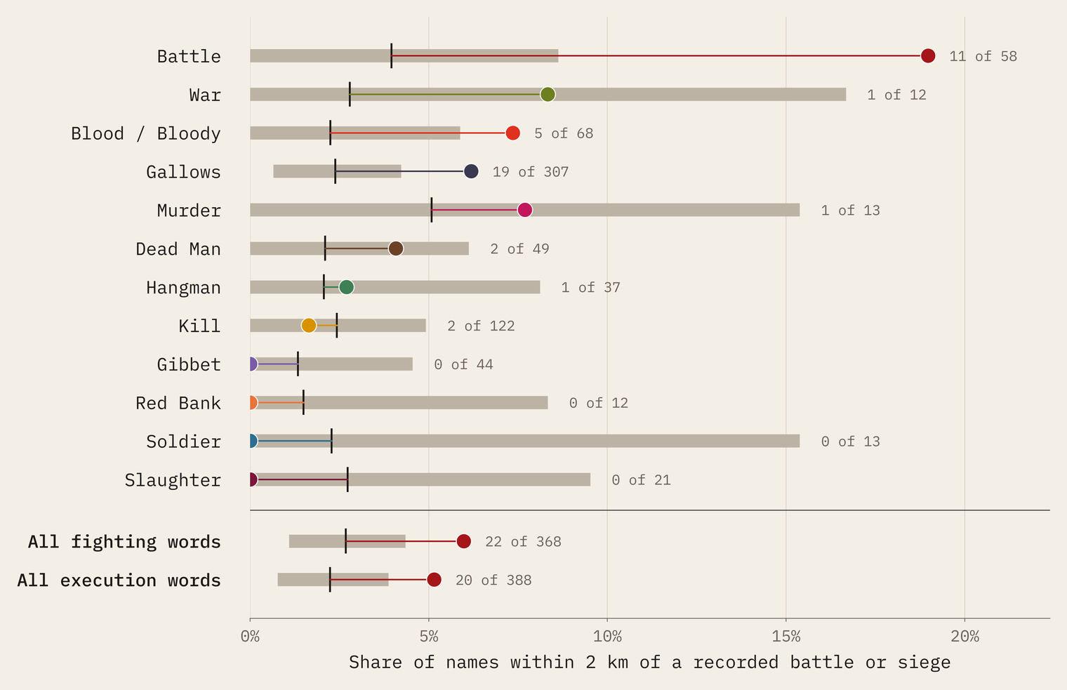
One word passes the test with ease. Of the 58 names containing Battle, 11 lie within 2 km of a recorded battle or siege, where the stand-ins would give about 2.3. That is 4.8 times as many as chance, and not one of the 2,000 matched sets did as well. The closest are the ones you would hope for: Battle Moor in Northumberland, 0.1 km from the point for the Battle of Grindon; the Battlefield suburbs in Glasgow (Langside) and Shrewsbury; Battleton Holt by Edgehill; and the town of Battle, 0.6 km from the point for Hastings.
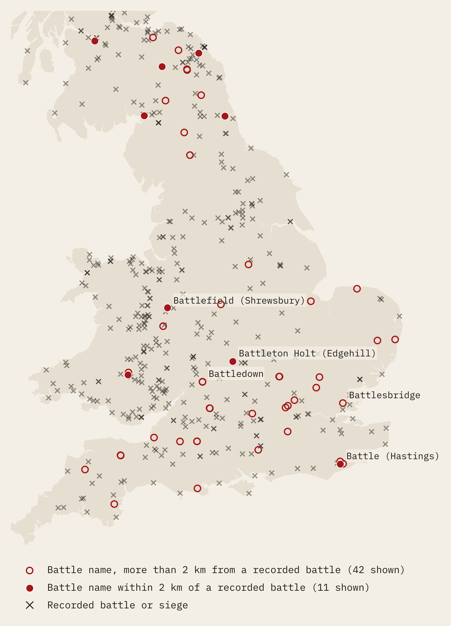
Even so, most Battle names are nowhere near a recorded battle. Battlesbridge in Essex, Battledown in Cheltenham and dozens of Battle Woods and Battle Hills are many kilometres from any fight I can place. Some may remember skirmishes that never made the record. Some will have nothing to do with fighting at all.
For most of the lurid words, the map is no closer to a battlefield than chance would put it.
Bloody, Gallows, and the rest
Bloody names show a weaker pull: 5 of 68 within 2 km against about 1.5 expected, including the Bloody Meadows at Tewkesbury and Towton. But with twelve words tested, one result of that size could be luck, and it does not pass a strict correction for multiple tests.
Gallows names also sit nearer battles than their stand-ins: 19 within 2 km against about 7.3 expected. But when I also matched the stand-ins on distance to the nearest town, much of that went away. Gallows names and battles, many of them sieges, share a neighbourhood: the link runs through the town more than through the name.
For Kill, Dead Man, Murder, Hangman, Gibbet, Soldier, War, Red Bank and Slaughter I found nothing at 2 km that chance does not explain. Kill names are the clearest case: 2 of 122 within 2 km, against about 3.0 expected.
The Slaughter trap
Upper and Lower Slaughter are the best-known red herrings on the map. Their Wikipedia articles derive the name from an Old English word meaning “wet land”: “slohtre” for Upper Slaughter, “slough” for Lower Slaughter. Nothing to do with killing.
And here is the twist. Both villages are only about 4.9 km from the Wikidata point for the Battle of Stow-on-the-Wold, fought in 1646. A naive count of “names near battles” would chalk them up as proof. That is exactly why the test needs a baseline. Warcop in Cumbria is a trap of the other kind: it starts with “War”, but Wikipedia says the name means “hill with a cairn”, and my search for War as a whole word leaves it out.
Does it hold up?
I reran the test with battles only, events before 1700, events dated 1066 to 1746, without 15 battles whose Wikidata point sits far from the place they are named after, and with stand-ins matched on distance to towns. Battle stays 4 to 6 times above chance in every version. Gallows is the one that moves.
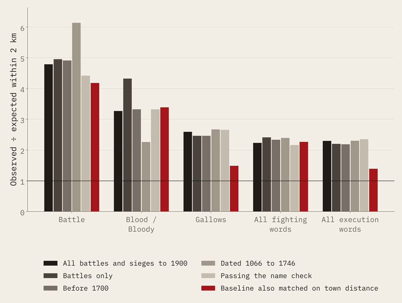
Turn it round and look at the battles: 43 of the 507 have a grim name within 2 km. Swap in the stand-ins and you would expect about 21. So roughly half of those close encounters are a real signal, and half are what you would see anyway.
How I did this
Names come from OS Open Names, the Ordnance Survey’s open gazetteer (OGL v3), searched for battle, blood, slaughter, red bank, dead man, murder, kill, war, soldier, gallow, gibbet and hangman. Battles and sieges come from Wikidata (CC0): those with a coordinate on British land, dated up to 1900. I left out one plainly misplaced point, the First Battle of St Albans, which Wikidata puts in Essex. For each name I drew 2,000 random OS names of the same type from the same 50 km square, and compared distances to the nearest recorded battle.
The limits matter. OS Open Names leaves out field names, where many local “Bloody Field” stories live. Wikidata misses many fights, places some at the nearest town, and covers England, Scotland and Wales unevenly. And distance is not meaning: I have not traced the history of any single name, and make no claim about what any of them means beyond what the cited sources say.
Notes and sources
- Place names: OS Open Names. Contains OS data © Crown copyright and database right 2026, Open Government Licence v3.0.
- Battles and sieges: Wikidata, CC0.
- Name origins quoted from Wikipedia: Upper Slaughter, Lower Slaughter, Warcop, Battle, East Sussex, Battlefield, Shropshire.
- Paper, data and code: Zenodo and GitHub.
- I wrote the text, with drafting and editing assistance from Claude (Anthropic), which also helped prepare the analysis code. I reviewed and checked all text and results.

