
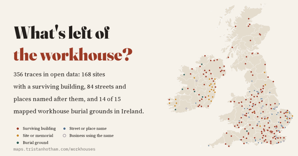
Most market towns once had a workhouse. Most have gone, but they left traces: buildings that became hospitals and flats, lanes named after them, and in Ireland the graves of the famine. I went looking for those traces in open data, and found 356 of them, along with a clear view of how much is missing.
The workhouse is one of those institutions everyone has heard of and few people can place. From the Poor Law Amendment Act of 1834 until the poor law ended in 1948, the workhouse was where the destitute went when there was nowhere else: a big, deliberately grim building where you got food and a bed in return for work and your freedom. Ireland got its own system in 1838, just in time for the Great Famine. Scotland built poorhouses after 1845.
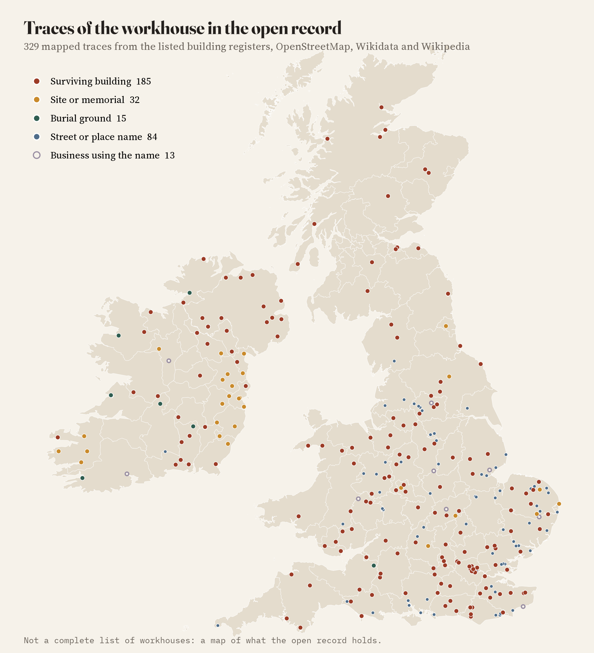
I wanted to map them, and quickly ran into a problem. There is no open, complete list. The great work on the subject is Peter Higginbotham’s workhouses.org.uk, which is a lifetime of research but not open data, and I have not used it. So I asked a different question: what traces of the workhouse can I find in the open record? I searched the listed building registers of England, Scotland, Wales and Northern Ireland, OpenStreetMap, Wikidata and Wikipedia, and sorted what I found into surviving buildings, sites and memorials, burial grounds, street and place names, and businesses that use the name.
What survives
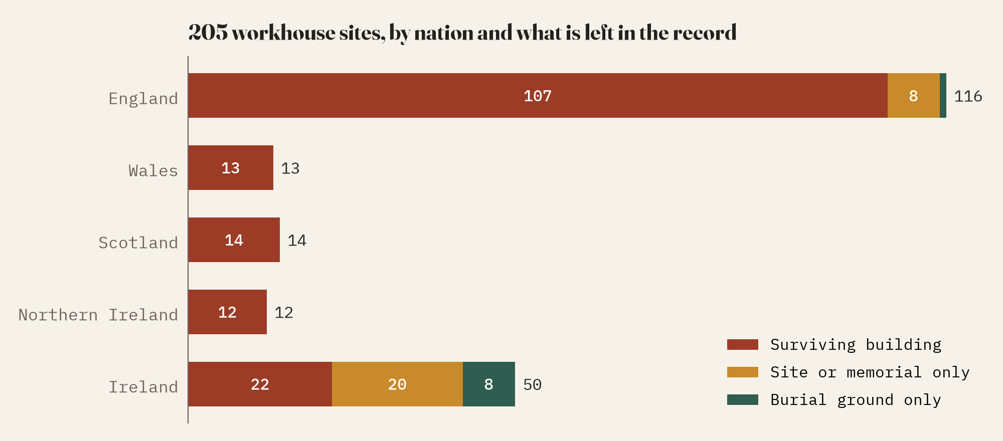
Grouping traces that sit within a few hundred metres of each other gives 205 workhouse sites, 168 of them with a surviving building in the record. Most of the listed ones are modest: 96% of the workhouse list entries in England and Wales are Grade II. The single Grade I is the poor house tucked inside the walls of Framlingham Castle, built in 1729.
The lists also have a bias I did not expect. More entries call themselves a poor house or simply “The Old Workhouse” (14 and 12) than name a union (29). Many listed workhouses are the small parish poorhouses of the 1700s, now cottages, rather than the great Victorian union workhouses, which tend to be listed under the name of the hospital they became.
Hospitals, flats and a few museums
For 80 sites the record says what the surviving building became. Hospitals (30) and homes (29) make up 74% of them. That is the poor law’s afterlife in a sentence: workhouse infirmaries became hospitals, went into the NHS in 1948, and when those hospitals closed the buildings were sold and turned into flats.
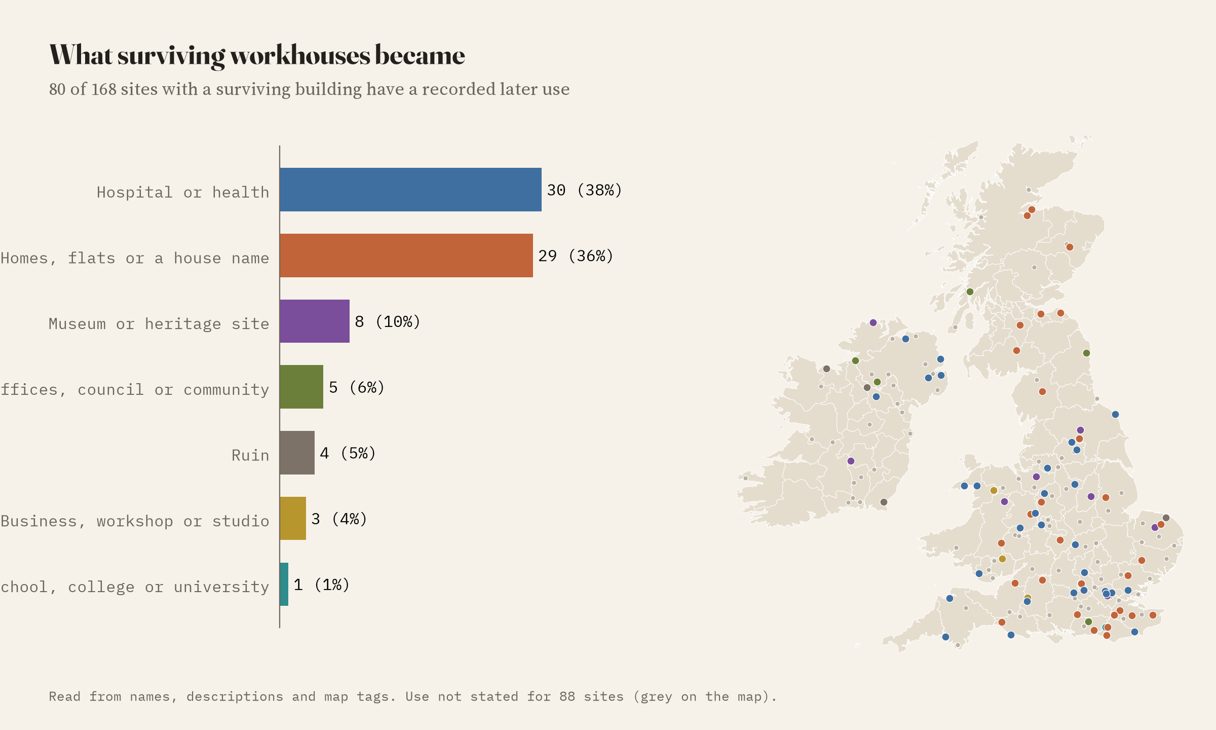
eight are now museums or heritage sites. The National Trust’s workhouse at Southwell in Nottinghamshire is the one to visit if you go to only one. Gressenhall in Norfolk, Llanfyllin in Powys and Ripon in North Yorkshire are also open, and the Cinema Museum in south London occupies part of the old Lambeth workhouse. In Ireland, Donaghmore in Laois and Dunfanaghy in Donegal tell the story of the famine.
Workhouse Lane
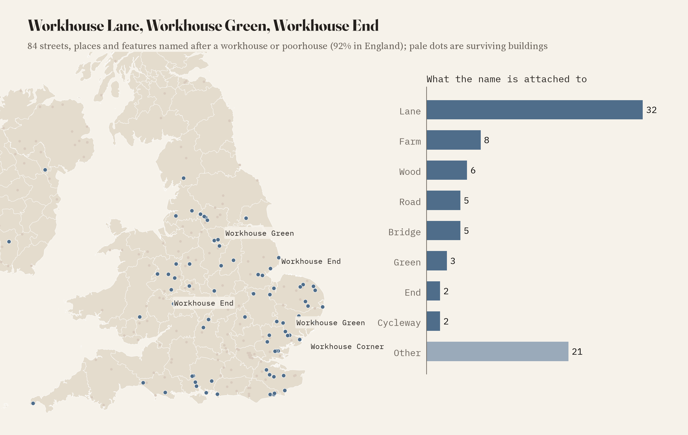
When the building goes, the name often stays. I found 84 streets, places and features named after a workhouse or poorhouse: 32 lanes, plus roads, farms, woods, bridges, a brook and cycleways, and hamlets called Workhouse Green and Workhouse End. 92% are in England, mostly in the east and south; Essex and Norfolk have 8 each. Most are rural lanes, and I suspect many led to an early parish workhouse rather than a Victorian union one.
Ireland: the famine workhouse
Ireland’s traces look different. Only 55% of the island’s 62 sites have a surviving building in the record, against 94% in Britain. Part of that is my sources: the Republic’s register of historic buildings is not among them, and many Irish sites come from OpenStreetMap features carefully marking the “site of” each union workhouse in Leinster and Kerry. But the burial grounds are another matter. Of the 15 workhouse burial grounds mapped in OpenStreetMap, 14 are in Ireland.
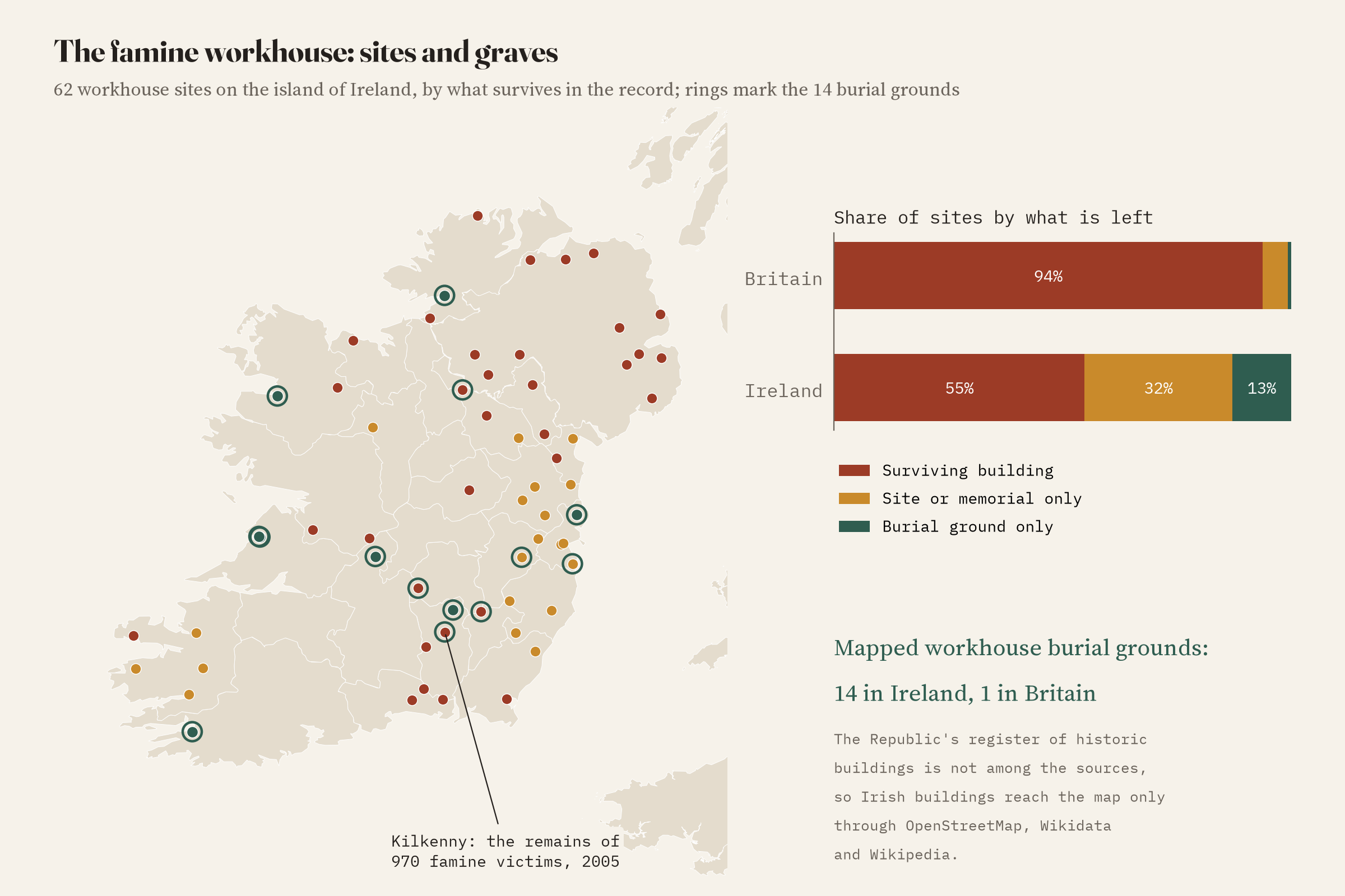
The Irish workhouses opened just as the famine began, and were overwhelmed by it. The dead were often buried in mass graves beside them. One memorial in the data, at the old Kilkenny workhouse, says it better than I can: “Herein lie the remains of 970 famine victims discovered at this Workhouse site in 2005. They were paupers of the Kilkenny Union Workhouse whose deaths occurred between August 1847 and March 1851. Their names were not recorded.”
In Britain the workhouse survives as hospitals and flats. In Ireland it survives as graves.
How complete is this? Not very
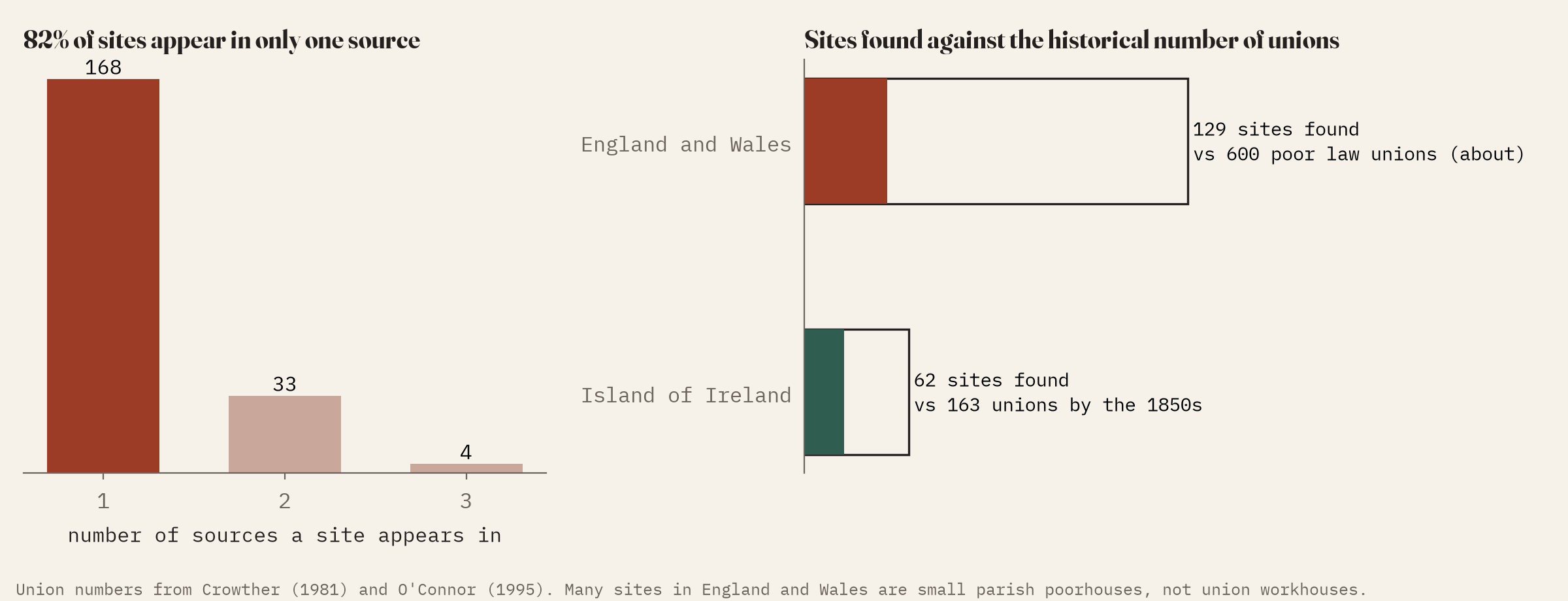
I want to be clear about this. There were around 600 poor law unions in England and Wales and 163 in Ireland by the 1850s, plus Scotland’s poorhouses and thousands of earlier parish workhouses. I found 129 sites in England and Wales and 62 on the island of Ireland. The four sources barely overlap: 82% of sites appear in only one of them. A workhouse listed as “St Mary’s Hospital” is invisible to a name search. So this is a map of what the open record holds, not of the workhouses themselves.
How I did this
I searched the names of all 465,740 entries on the four UK listed building registers for words such as workhouse, poorhouse, union house, house of industry and casual ward, and threw out the false friends: bridewells and houses of correction, pauper lunatic asylums, Norwich Union offices and Grand Union canal buildings. From OpenStreetMap I took 230 features whose names mention a workhouse or poorhouse and classed them by their tags, leaving out electricity transformers and a townland whose name only sounds like a workhouse. From Wikidata and Wikipedia I took items classed as workhouses or poorhouses and pages in the workhouse categories. Duplicates across sources were merged, and buildings, sites and graves within 350 metres were grouped into sites. What a building became is read from words in its name, description and tags, with nine corrections by hand. The history comes from the books listed below, not from the data. The paper sets out every step and caveat.
If you want the full story of a particular workhouse, go to workhouses.org.uk. And if you know of a trace I have missed, the best fix is to add it to OpenStreetMap or Wikidata, where the next person can find it too.
Notes and sources
- Listed buildings: National Heritage List for England (Historic England), Historic Environment Scotland, Cadw and Northern Ireland Department for Communities. Open Government Licence v3.0.
- OpenStreetMap contributors, via the Overpass API. ODbL 1.0.
- Wikidata (CC0) and English Wikipedia (CC BY-SA 4.0).
- County outlines: ONS and OSNI (OGL) and Natural Earth (public domain).
- History: Slack, P. (1990) The English Poor Law, 1531-1782; Crowther, M. A. (1981) The Workhouse System 1834-1929; Morrison, K. (1999) The Workhouse: A Study of Poor-Law Buildings in England; O’Connor, J. (1995) The Workhouses of Ireland; Kinealy, C. (1994) This Great Calamity: The Irish Famine 1845-52; Fowler, S. (2007) Workhouse; Higginbotham, P. (2012) The Workhouse Encyclopedia.
- I wrote the text, with drafting and editing assistance from Claude (Anthropic), which also helped prepare the analysis code. I reviewed and checked all text and results.

