
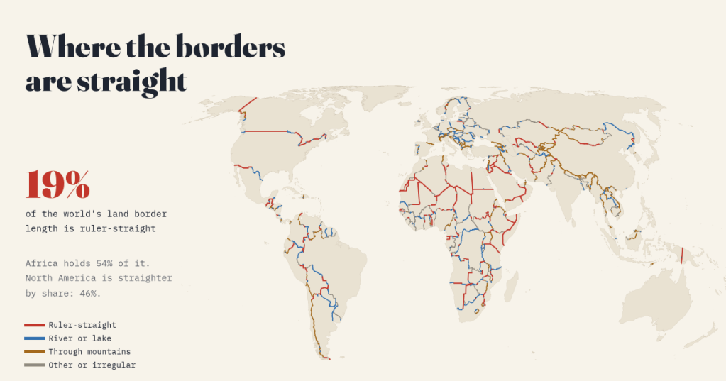
Africa’s borders are often called the straightest in the world, drawn with a ruler in European capitals. I measured every land border on Earth to see whether that is true, and looked up who drew the longest straight lines, and when. The answer is yes and no, and the longest straight border of all is not in Africa.
Some borders announce themselves. Look at a map of the Sahara, or Arabia, or the line between Canada and the United States, and the straight lines jump out: hundreds of kilometres without a bend, along a line of latitude or between two points someone chose far away. They are the most argued-about lines on the political map, a shorthand for empire and for borders drawn without asking the people who lived on them.
I wanted numbers. How much of the world’s border is actually straight? Where is it? And is Africa really the straightest continent? So I took every international land border in Natural Earth’s detailed world map, 233,534 km of line, and sorted every kilometre into one of four kinds: ruler-straight, river or lake, through mountains, or other.
About a fifth of the world’s border is straight
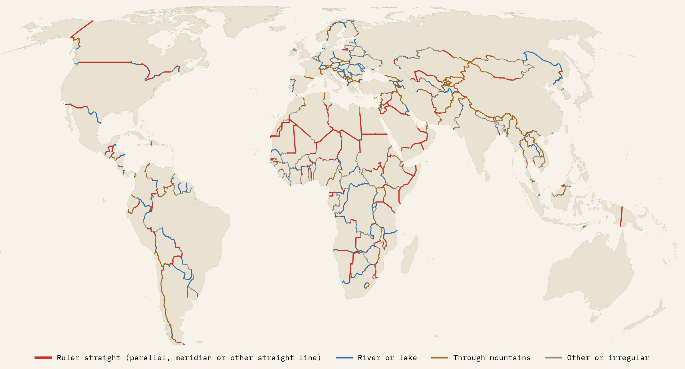
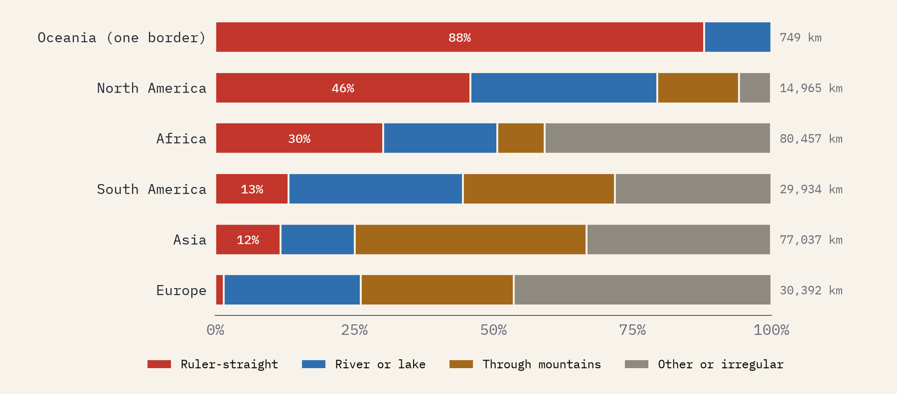
Of 233,534 km of land border, 45,232 km, or 19.4%, runs in straight lines of at least 50 km. Rivers and lakes carry 20.9%, mountains 24.7%, and the remaining 35.0% wanders across lowland, following old estates, villages, survey marks and compromises. Only about a third of the straight length follows a parallel or a meridian; the rest are straight lines between two chosen points.
The continents could hardly be more different. Europe’s borders are almost never straight (1.5%), and France, Germany and the United Kingdom have no straight border at all. Asia’s run through mountains. South America’s follow rivers and the Andes.
So is Africa the straightest?
By quantity, yes. Africa has 24,332 km of straight border, 54% of the world’s total, far more than anywhere else, and the largest share of borders that are mostly straight. 25 of the 40 longest straight lines on Earth are in Africa.
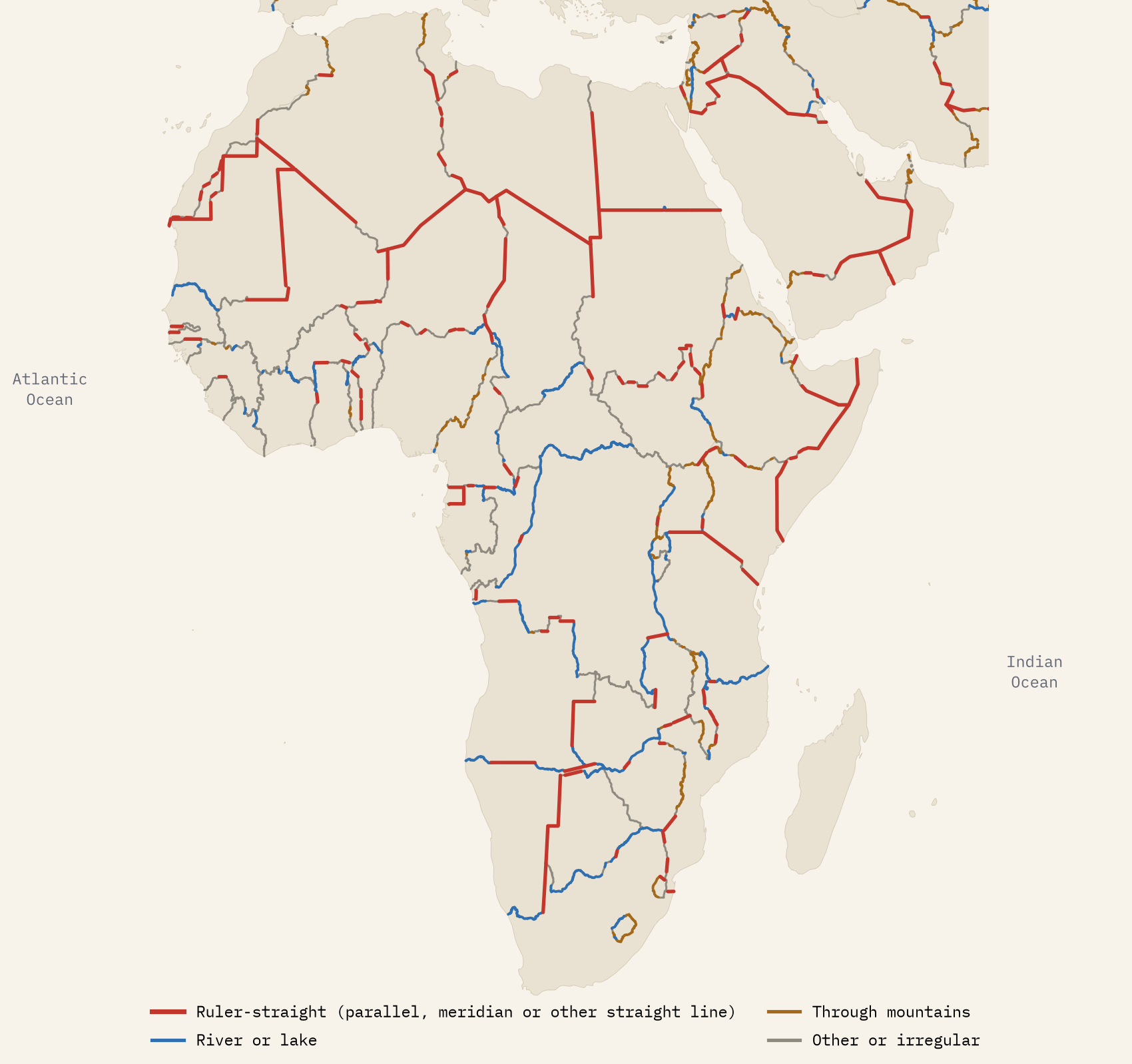
By share, no. Africa’s borders are 30.2% straight. North America’s are 45.9%, because of one enormous, very straight border: Canada and the United States, 59% straight over 8,352 km. Take that out and North America falls to 28.9%, just below Africa. I tried twelve different definitions of straight, stricter and looser, and North America came first and Africa second every time. Most of Africa’s border, 41%, is neither straight nor natural, but irregular. The often quoted figure that 44% of Africa’s borders follow parallels and meridians, which goes back to a 1961 study of tropical Africa, also looks high: on today’s borders I find 12.3%.
Africa has more straight border than anywhere else, 54% of the world’s. But kilometre for kilometre, North America is straighter.
Who drew the longest lines
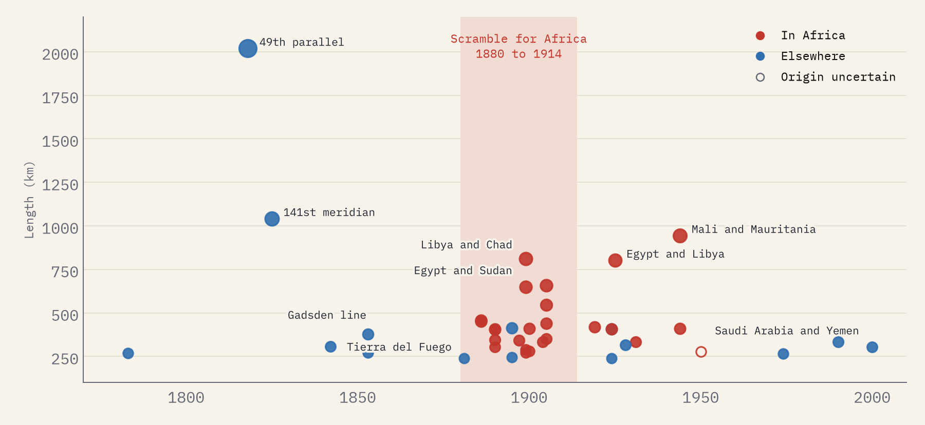
The longest straight border segment in the world is the 49th parallel between Canada and the United States, 2,020 km from Lake of the Woods to the Strait of Georgia, agreed by Britain and the United States in 1818 and carried to the Pacific in 1846. Second is the 141st meridian between Alaska and the Yukon, set by Russia and Britain in 1825. Then come the Sahara’s lines: Mali and Mauritania, Libya and Chad, and the 25th meridian between Egypt and Libya, agreed by Italy and Egypt in 1925. Egypt and Sudan’s 22nd parallel, from the Anglo-Egyptian agreement of 1899, adds up to 1,212 km.
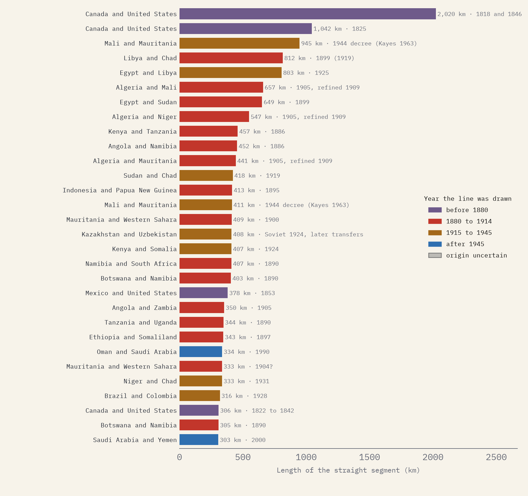
I looked up the treaty behind each of the 40 longest straight lines, using standard reference works on boundaries. 21 of the 40 with a date were set between 1880 and 1914, the years of the Scramble for Africa. The United Kingdom was a party to 21 of them, France to 11 and Germany to 6. But the list is not only European. The oldest lines are North American, the newest were agreed by Saudi Arabia, Oman, Yemen and the Emirates between 1974 and 2000, and several of the longest Saharan lines were never treaties at all: they were limits France drew between its own colonies, which became international borders at independence. Only one line, the provisional line between Ethiopia and Somalia, has a date I could not pin down, and I have marked it as uncertain rather than guess.
Rivers and mountains
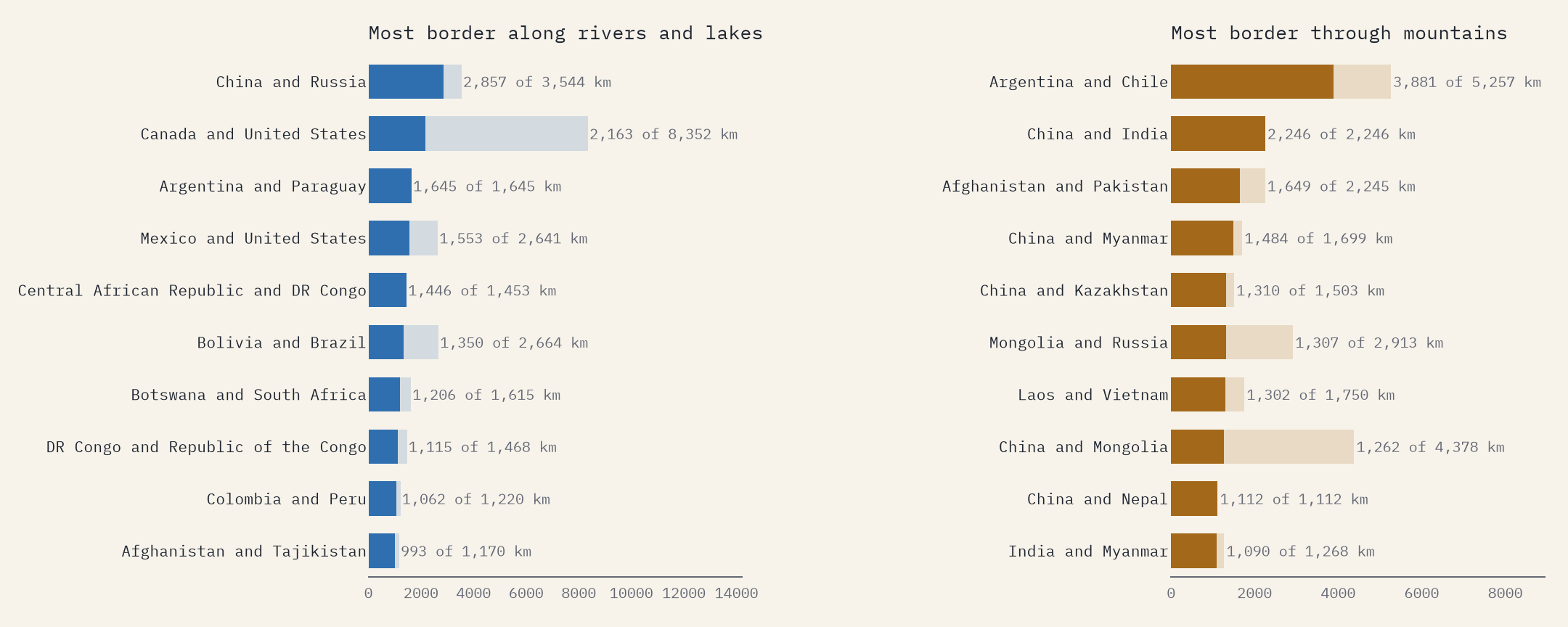
Water is the commonest natural border. China and Russia’s is 81% river, along the Amur and Ussuri, and Argentina and Paraguay’s is all river. Argentina and Chile share 3,881 km through the Andes, and China and India’s whole border runs through the Himalaya and Karakoram. One caution: the world map of rivers I used misses small streams, so some river borders count as other here.
The map has a ruler too
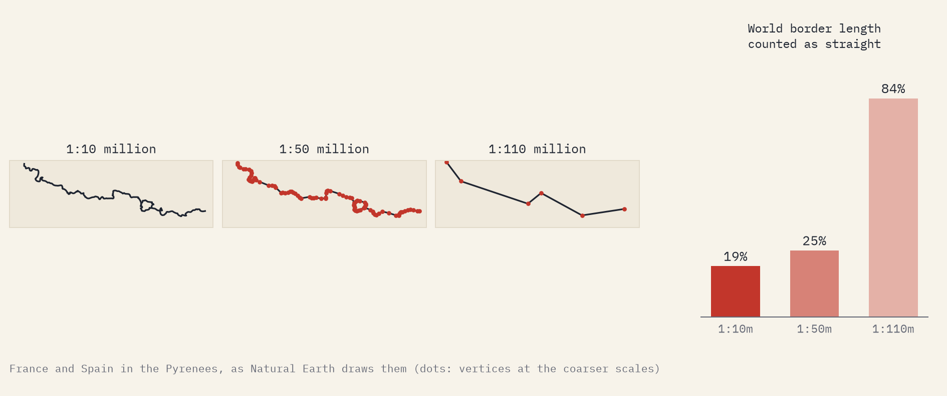
One thing surprised me. How straight a border looks depends on how much the map has been simplified. On Natural Earth’s detailed map, 19.4% of the world’s border counts as straight. On its 1:50 million map, the same method finds 25.4%. On its small-scale 1:110 million map, the kind used for many world maps online, it is 83.6%: simplify the Pyrenees enough and they become a few straight strokes. So any claim about straight borders depends on the map behind it, and mine, at 1:10 million, still smooths some small bends.
How I did this
The borders are Natural Earth’s 1:10 million land boundary lines, including disputed and ceasefire lines as Natural Earth draws them. A stretch counts as straight if every point on it lies within 1 km of a single great circle or line of constant bearing (which includes every parallel) for at least 50 km. Rivers and lakes come from Natural Earth’s river and lake maps: a stretch follows water if it stays within 3 km of one for at least 15 km. Mountains come from the ETOPO5 world elevation grid, using a simplified version of a standard definition of mountain terrain. Each kilometre takes the first kind that fits, in that order. I tested many other settings: with a 50 km minimum the world’s straight share stays between 18.0% and 24.0%. The treaty table is my own compilation from published sources, with a confidence rating for each line, and I would welcome corrections. All the data and code are open.
Notes and sources
- Natural Earth boundary lines, countries, rivers, lakes and physical regions (public domain).
- ETOPO5 5 arc-minute global relief, NOAA National Geophysical Data Center (public domain).
- Treaty table compiled from Brownlie, I. (1979) African Boundaries: A Legal and Diplomatic Encyclopaedia; Biger, G. (1995) The Encyclopedia of International Boundaries; the US State Department’s International Boundary Studies; the International Court of Justice’s 1994 judgment on Libya and Chad; and Wikipedia’s border articles.
- Mountain terrain adapted from Kapos, V. et al. (2000), UNEP-WCMC. The 44% figure is usually traced to Barbour, K. M. (1961) on boundaries in tropical Africa.
- I wrote the text, with drafting and editing assistance from Claude (Anthropic), which also helped prepare the analysis code. I reviewed and checked all text and results.

