
Some beaches give you the whole show, the Sun sliding into an empty sea. Others hide it behind a headland, an island or the far side of a bay. I traced the Sun’s path from 1,717 named beaches in Britain and Ireland, day by day through the year, to find out which is which.
Ask anyone about a beach and the sunset comes up sooner or later. Can you watch it go down into the sea? The answer is less obvious than it looks, because the Sun does not set in the same place all year. At midsummer it goes down far to the north-west; at midwinter, well round in the south-west. A beach that looks due west may get its sea sunsets only in spring and autumn, with a headland at either end of its view taking the rest.
So for every named beach in OpenStreetMap I stood an imaginary person at the water’s edge and cast a fan of lines out to sea, one every quarter of a degree, along every bearing where the Sun sets or rises in the year. Then for each day I asked: does the line of sunset reach an open sea horizon, or does land get in the way?
Sunset coasts and sunrise coasts
47% of the beaches get a sea sunset on at least one day of the year, and 41% a sea sunrise. Only 52 have a sea sunset every single day, 43 of them on the Atlantic coast of Cornwall, where Sennen Cove looks out on nothing but ocean. A fifth of beaches, 21%, get neither: they sit in bays, estuaries and firths where land closes every view of the horizon at both ends of the day.
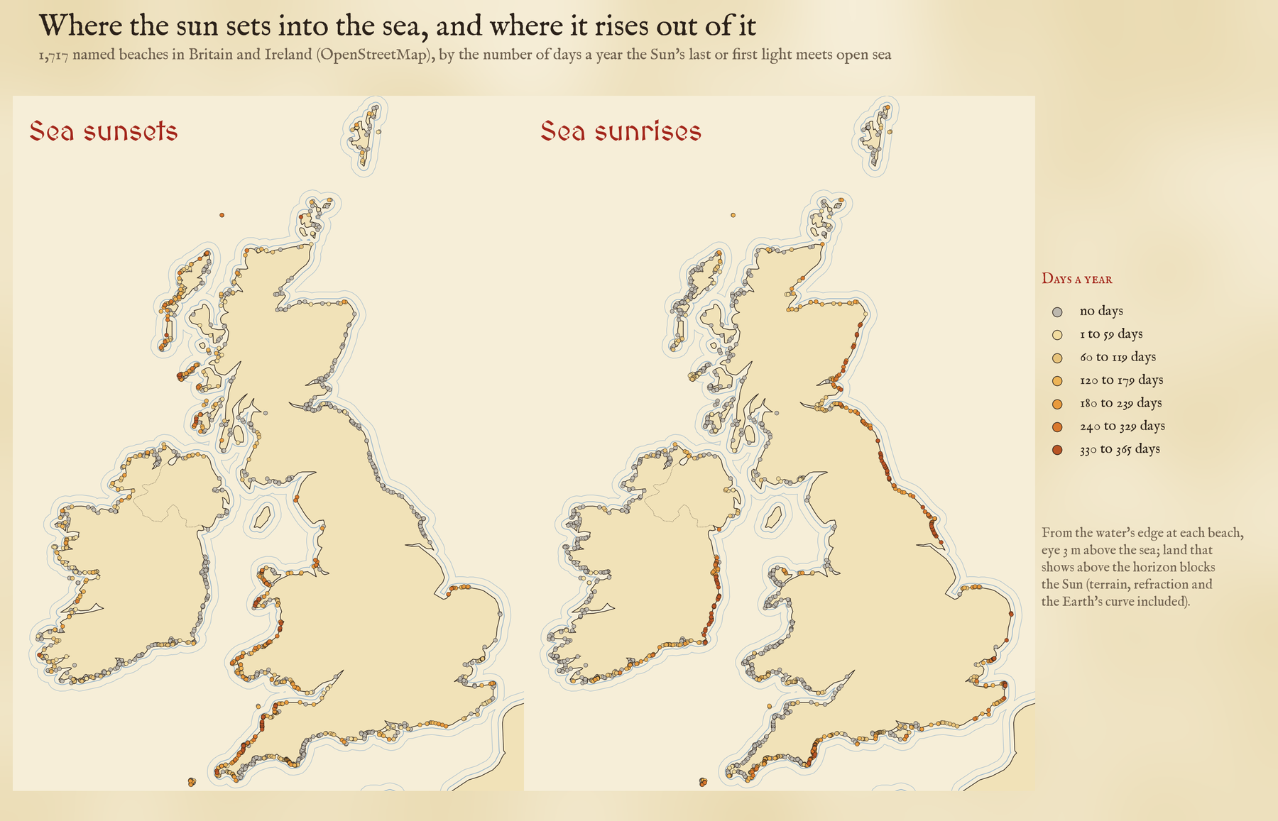
Wales is the sunset nation: 67% of its beaches see the Sun go down into the sea on some day of the year. The east coasts belong to the sunrise. From Longsands at Tynemouth, Killiney in Dublin and 15 beaches in Wexford, 14 in Wicklow and 10 in the East Riding of Yorkshire, the Sun comes up out of the sea every morning of the year. Only 152 beaches get both. Many of them face south or north across open water, so that the Sun can rise and set over the sea in the same season: 30 are along the Essex coast at Clacton, and 11 around the coast of Kent, from Margate to Folkestone and Broomhill Sands.
Winter is better
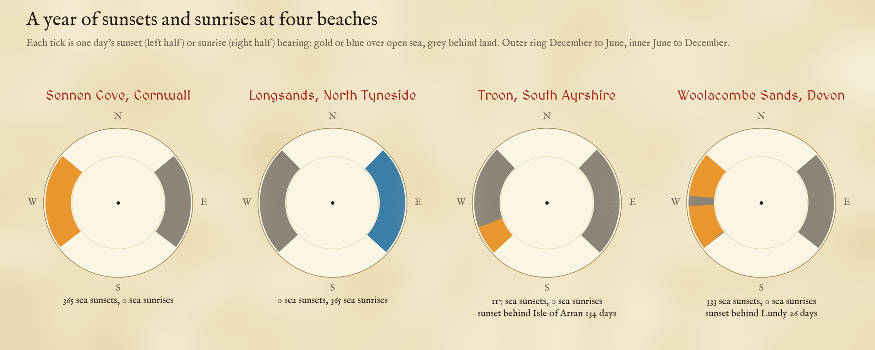
If you want a sea sunrise, go in winter. On 21 December 405 beaches see the Sun rise out of the sea; on 21 June only 231. Sea sunsets hold up better through the year, but winter still wins: 349 beaches on the shortest day against 303 on the longest. In winter the Sun rises and sets further south, and more of our beaches have an open view that way. Fistral at Newquay is the exception that proves it: 304 sea sunsets a year, but in deep winter the Sun goes down behind its own headland.
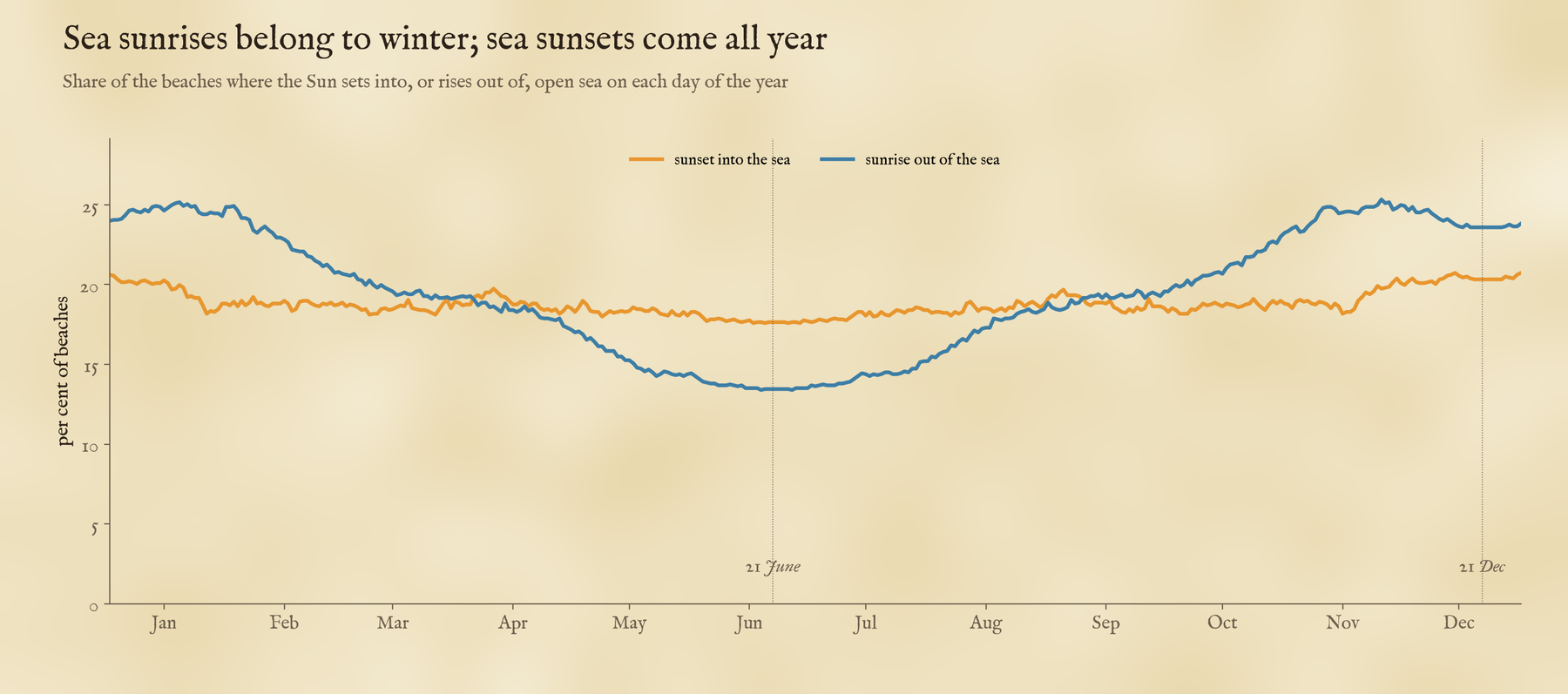
From Troon, Arran takes 134 sunsets a year.
Islands in the way
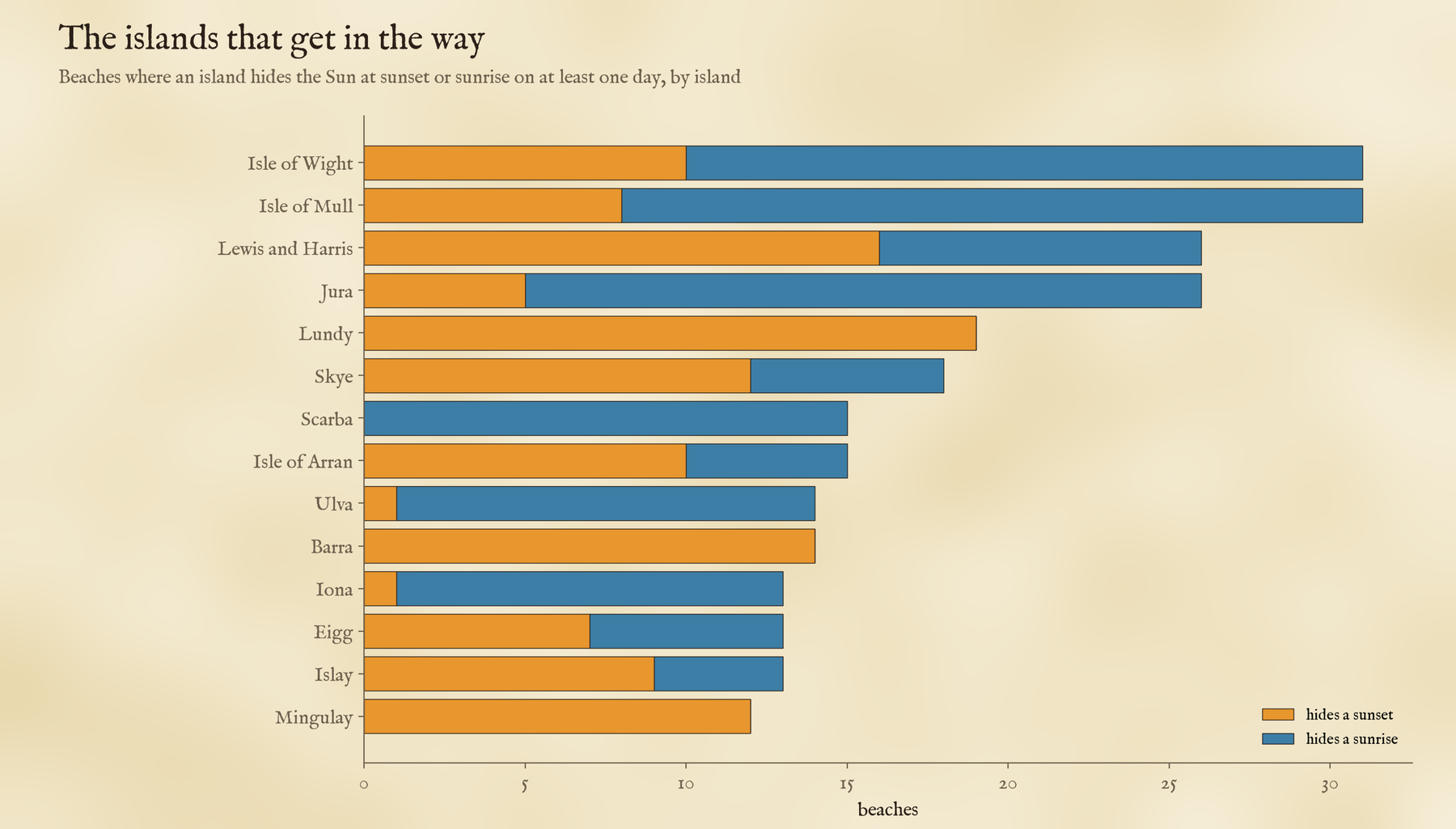
Islands take a bite out of the year. From Troon on the Ayrshire coast, the mountains of Arran stand in front of the setting Sun through spring and autumn. Lundy, a small island about 30 km out in the Bristol Channel, hides the sunset from Woolacombe on 26 days and from Croyde on 28, around the equinoxes, when the Sun goes down due west. The Isle of Man takes 44 sunsets from Fleswick Bay under St Bees Head, and 73 sunrises from the beaches of County Down. The Isle of Wight and Mull share the record, each getting in the way for 31 beaches: the Isle of Wight along the Solent and the Sussex coast, Mull from the beaches of Tiree, Coll and Iona at sunrise and around Oban at sunset.
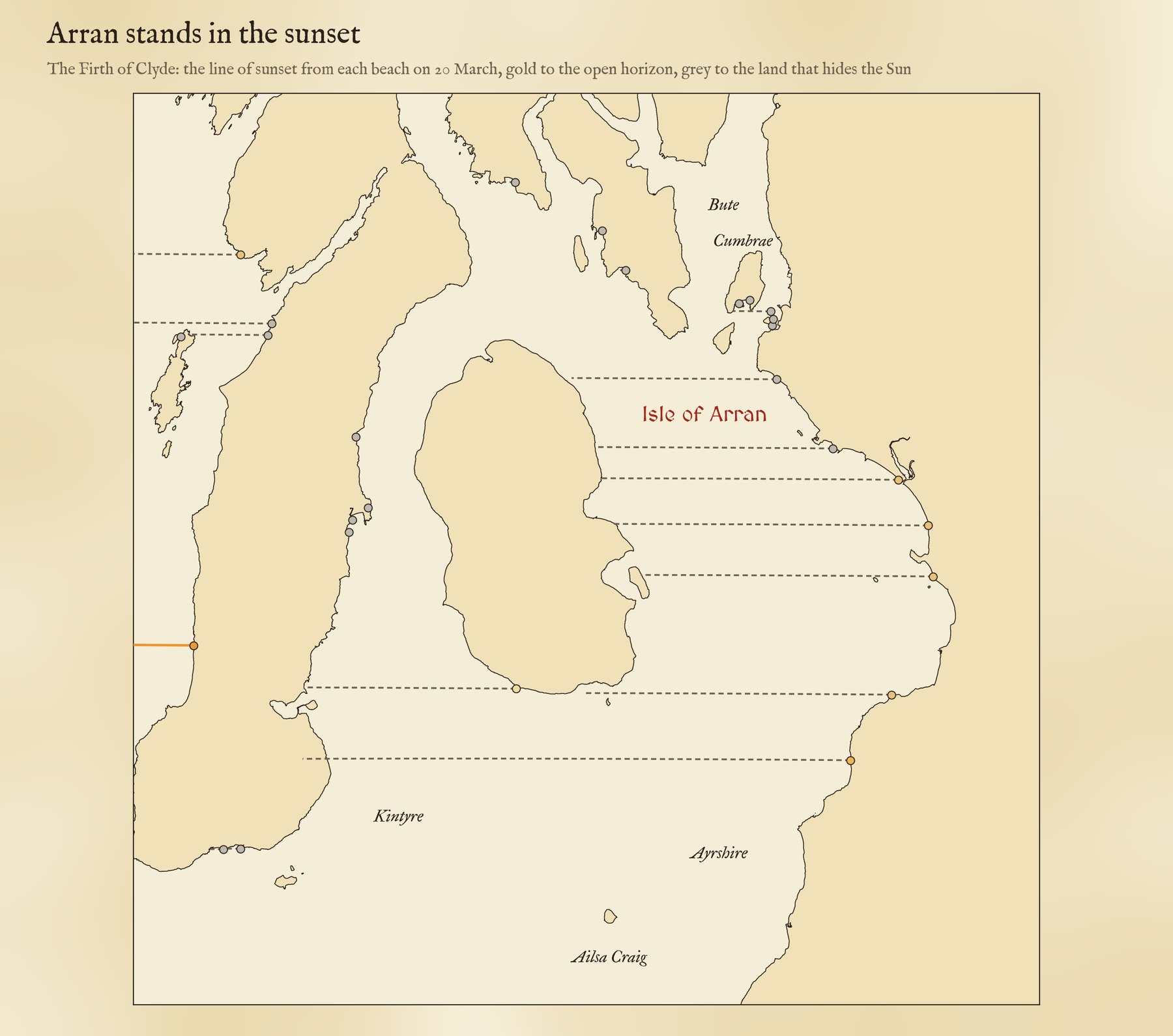
Distance matters as much as the islands themselves, because the sea curves away. Stand on a beach with your eyes 3 m above the water and the sea horizon is only about 7 km off; beyond that, land has to be tall to show. At 50 km the bottom 128 m of anything is hidden behind the curve of the sea. So the Isle of Man, over 100 km from Liverpool Bay, does not spoil the sunsets at Crosby, but Arran’s peaks, about 35 km from Troon, very much do.
How I did this
The beaches are every named beach in OpenStreetMap in the UK and Ireland, with pieces of the same beach joined up and lake and river beaches left out. The sea is OpenStreetMap’s coastline, from the OpenFreeMap map tiles, turned into a grid of squares about 20 to 25 m across, out to 12 km from each beach. Beyond that I used the AWS terrain tiles, which tell you where land rises above sea level. On each beach I put the observer at the water’s edge, at whichever spot along the beach has the widest view of the year’s sunsets and sunrises, since you can walk along a beach. A piece of land counts as in the way only if it shows above the sea horizon, allowing for the Earth’s curve and the way air bends light near the ground. The Sun’s position comes from standard solar formulas for every day of 2026.
The caveats: this is about the line of sight, not the weather, so a sea sunset here is a promise of an open horizon, not of a clear evening. The coastline is the high water line, so on wide sands at low tide the sea in front of you is beach. The bending of light near the horizon changes from evening to evening, which can tip a borderline day either way. And only named beaches are in: Blackpool’s main beach has no name in the data. If your favourite beach is missing or wrong, it may be a question of what has been mapped. Tap any beach on the map to see its own year of sunsets.
Notes and sources
- Beaches and coastline: OpenStreetMap contributors (ODbL), queried with QLever and served as vector tiles by OpenFreeMap. Terrain: AWS Terrain Tiles. Islands and counties: Natural Earth.
- Sun: solar declination after J. W. Spencer, Fourier series representation of the position of the sun, Search (1971).
- I wrote the text, with drafting and editing assistance from Claude (Anthropic), which also helped prepare the analysis code. I reviewed and checked all text and results.

