
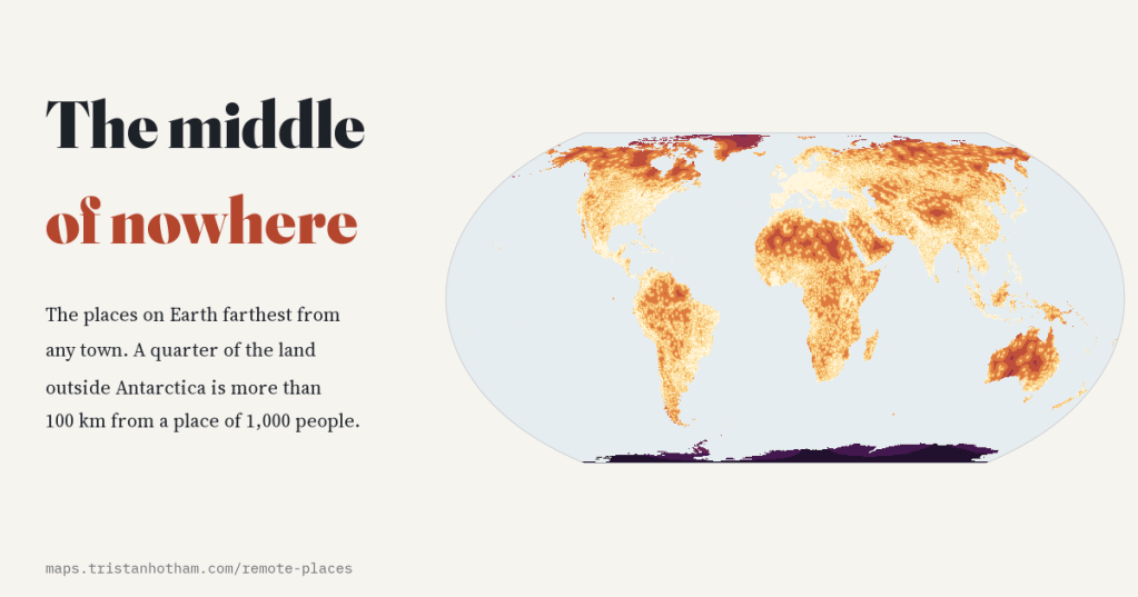
Where on Earth is farthest from everyone? I measured the distance from every patch of land to the nearest town, the nearest big city and the nearest sea, and went looking for the middle of nowhere on every continent, in every country and in Britain.
Geographers have long hunted for the poles of inaccessibility, the points on each continent farthest from the sea. The most famous lies in the Dzungarian basin of north-west China, about as far from any ocean as you can get. But it is not remote at all: by my count it is 65 km from a town. Being far from the sea is not the same as being far from people.
So I asked a different question: which places are farthest from any town? I covered all of the world’s land with a grid of cells a tenth of a degree across, 2,147,063 of them, and for each one measured the straight-line distance over the globe to the nearest of 171,737 places of 1,000 or more people in the GeoNames gazetteer. I did the same for cities of 100,000 and of a million, and for the coast.
A quarter of the land is far from a town
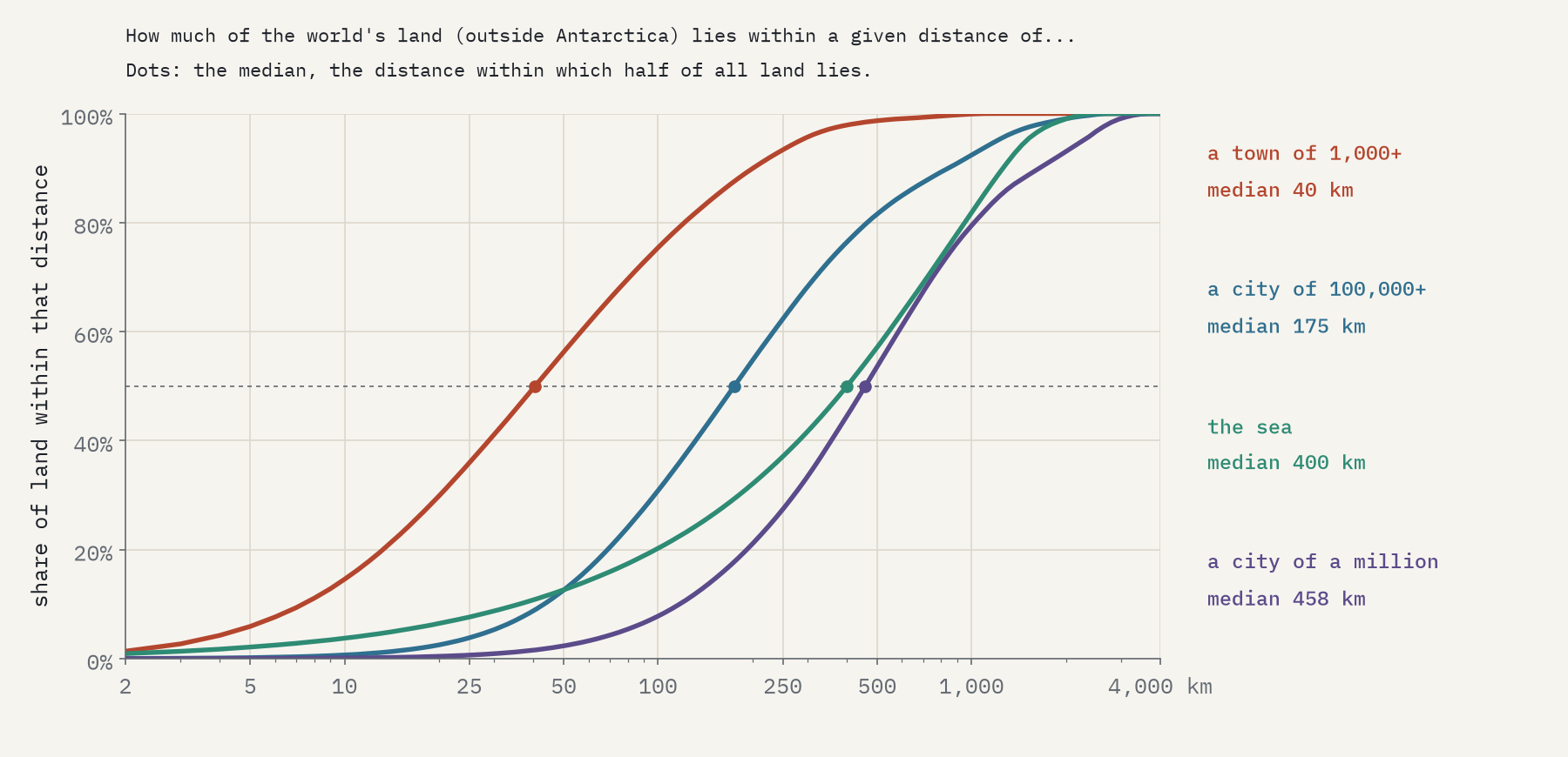
Most land is not far from someone. Half of the land outside Antarctica lies within 40 km of a town. But 24.6% of it, 33.1 million square kilometres, is more than 100 km from the nearest one, and 1.3% more than 500 km. Big cities are far sparser: half of all land is more than 458 km from a city of a million.
The emptiness is concentrated in the far north and in the deserts. Land north of 60°N is 13% of the total, but it holds 35% of the land more than 100 km from a town and 93% of the land more than 500 km away.
The middle of nowhere, continent by continent
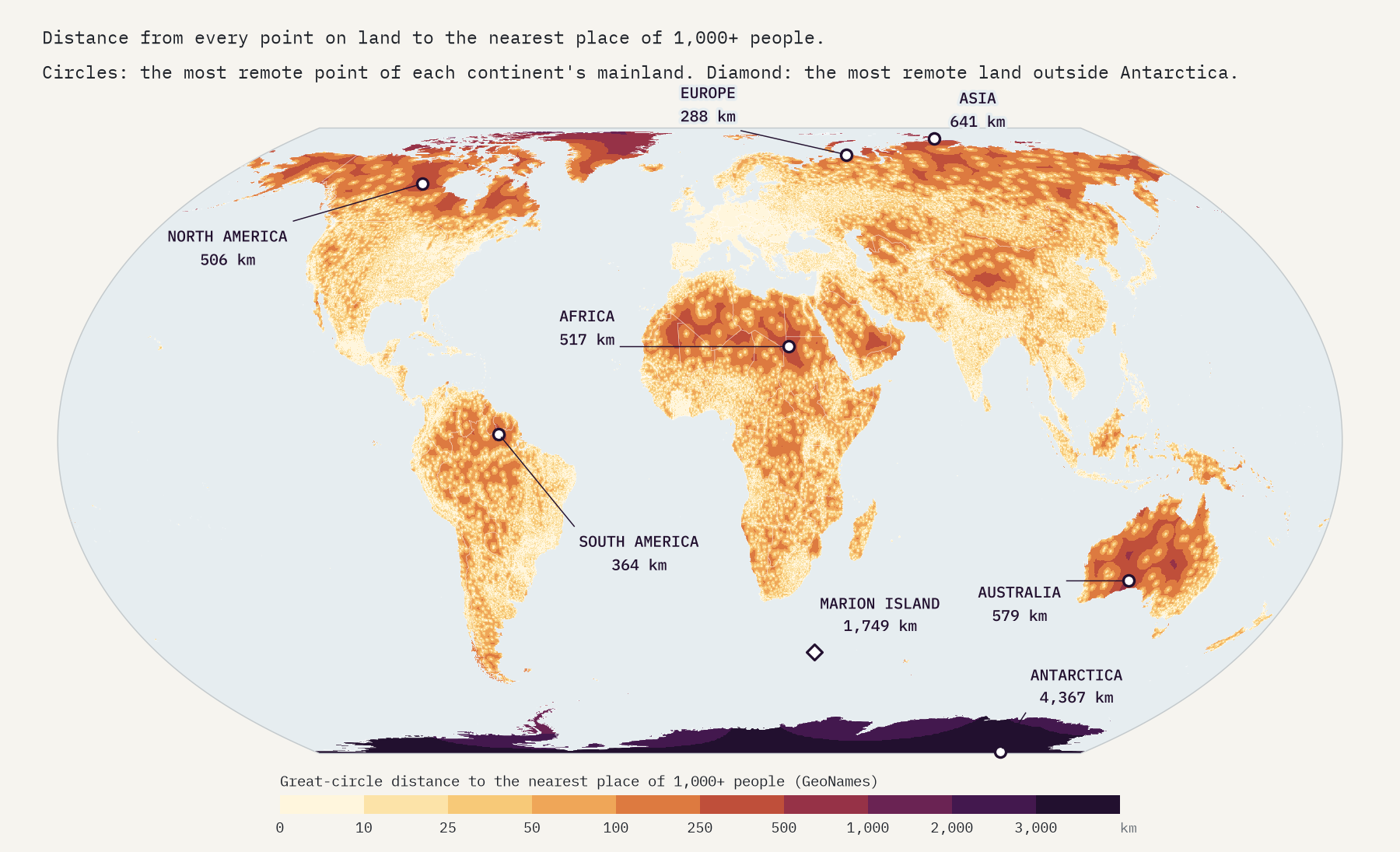
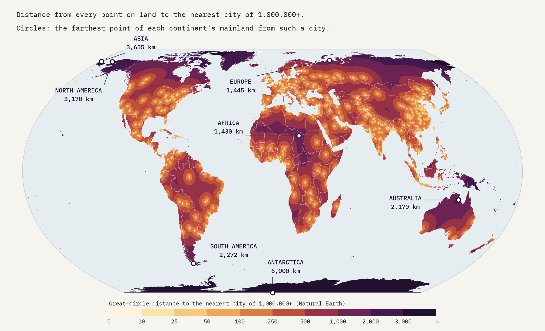
On Asia’s mainland the most remote spot is Cape Chelyuskin, the northernmost tip of Eurasia, 641 km from Khatanga. Australia’s is in the Great Victoria Desert, 579 km from Ceduna. Africa’s is in the Libyan Desert of north-western Sudan, 517 km from a town. North America’s is in the far north of Saskatchewan (506 km), South America’s in the rainforest of northern Brazil near Suriname (364 km), and Europe’s on the Kara Sea coast of north-eastern European Russia (288 km).
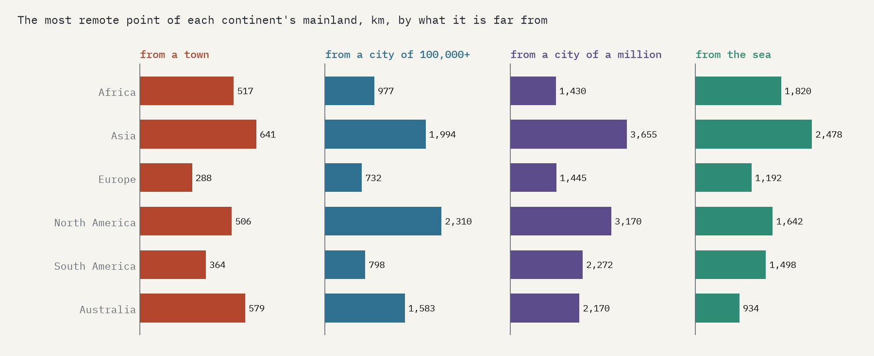
The far-from-the-sea poles land where published calculations put them: near Obo in the Central African Republic, in South Dakota, in Mato Grosso in Brazil, west of Alice Springs, and in Dzungaria, where my coastline puts the point 2,478 km from the sea and 169 km from the usual position. Not one of them is far from a town.
Count islands and the record goes to a rock in the Southern Ocean. Marion Island, one of South Africa’s Prince Edward Islands, is 1,749 km from the nearest town, Port Alfred in the Eastern Cape. In the Arctic, Cape Columbia at the top of Canada’s Ellesmere Island is 1,170 km from a town. And Antarctica, which has research stations but no towns, is in a class of its own: every point of it is at least 879 km from one, and the most remote 4,367 km.
The most landlocked place on Earth is 65 km from a town. Being far from the sea is not the same as being far from people.
Every country’s empty quarter
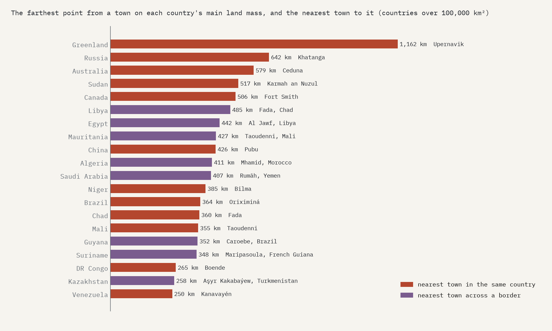
For every country I found the point inside its borders farthest from any town, at home or abroad. On each country’s main land mass Greenland comes first, 1,162 km from Upernavik, followed by Russia, Australia, Sudan and Canada. Often the nearest town is in another country: the deep Sahara of Libya is closest to Fada in Chad, and Saudi Arabia’s Empty Quarter to Rumāh in Yemen. That is true for 34 countries.
Cities of a million are another story. From the far north of Chukotka the nearest is 3,655 km away, and from the Marquesas Islands in French Polynesia, the most remote land of all on this measure, 5,231 km.
And in Britain?
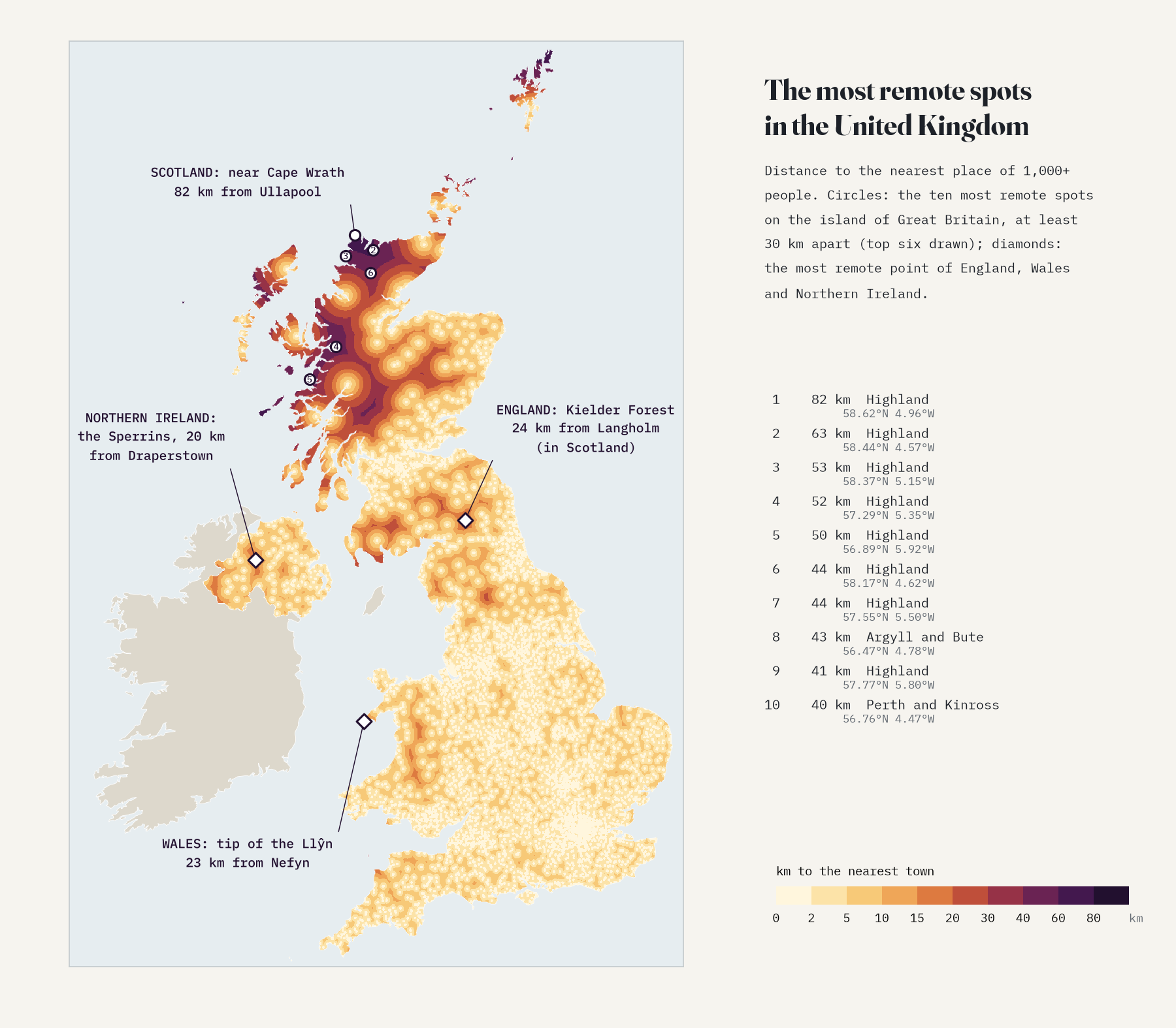
In a crowded island remoteness shrinks to tens of kilometres: half of Great Britain is within 4.2 km of a town. The most remote spot on the mainland is near Cape Wrath, the north-west tip of Scotland, 82 km from Ullapool, and nearly all of the ten most remote spots are in the Highland council area. England’s is in Kielder Forest in Northumberland, 24 km from a town, and the nearest town is Langholm, over the border in Scotland. Wales’s is the very tip of the Llŷn Peninsula, 23 km from Nefyn, and Northern Ireland’s is in the Sperrin Mountains, 20 km from Draperstown.
What this is, and is not
“Far from a town” does not mean empty. The gazetteer counts places of 1,000 or more people, so it misses villages, hamlets, Inuit settlements, oases and research stations, and it keeps a handful of smaller administrative seats, such as the French base on Kerguelen. Distances are straight lines over the globe, not journeys: 50 km of Highland bog can take longer to cross than 500 km of desert road. For travel time, the Malaria Atlas Project’s global map of accessibility to cities for 2015 (Weiss and others, Nature, 2018) is the place to look. The grid is a tenth of a degree, refined to about a kilometre at each maximum. The paper sets out every step and caveat.
Notes and sources
- GeoNames, cities1000 gazetteer (all populated places of 1,000 or more people), CC BY 4.0, as packaged by lutangar/cities.json.
- Natural Earth populated places, land and country outlines (public domain).
- I wrote the text, with drafting and editing assistance from Claude (Anthropic), which also helped prepare the analysis code. I reviewed and checked all text and results.

