
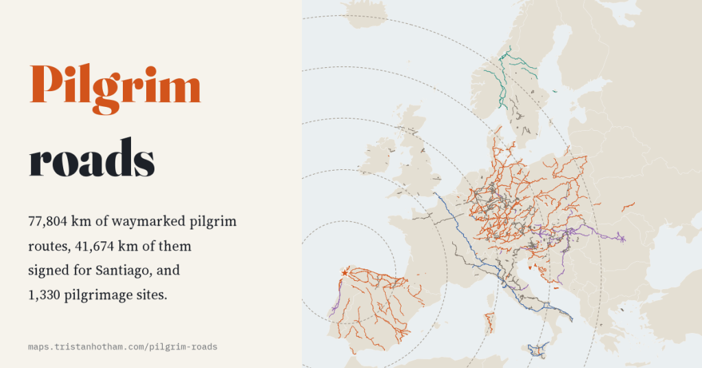
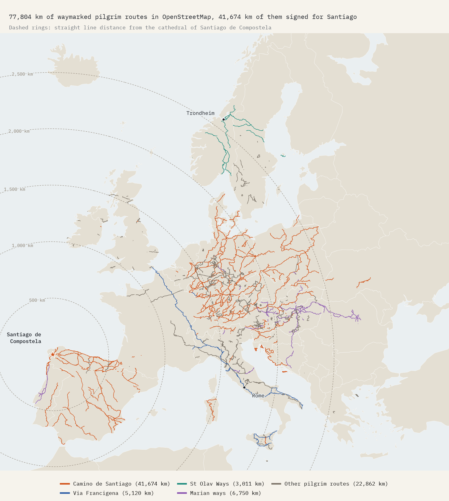
I measured every waymarked pilgrim route I could find in OpenStreetMap, without counting any stretch twice: 77,804 km of them. More than half lead to Santiago de Compostela, and there is more of the Way of St James in Germany than in Spain.
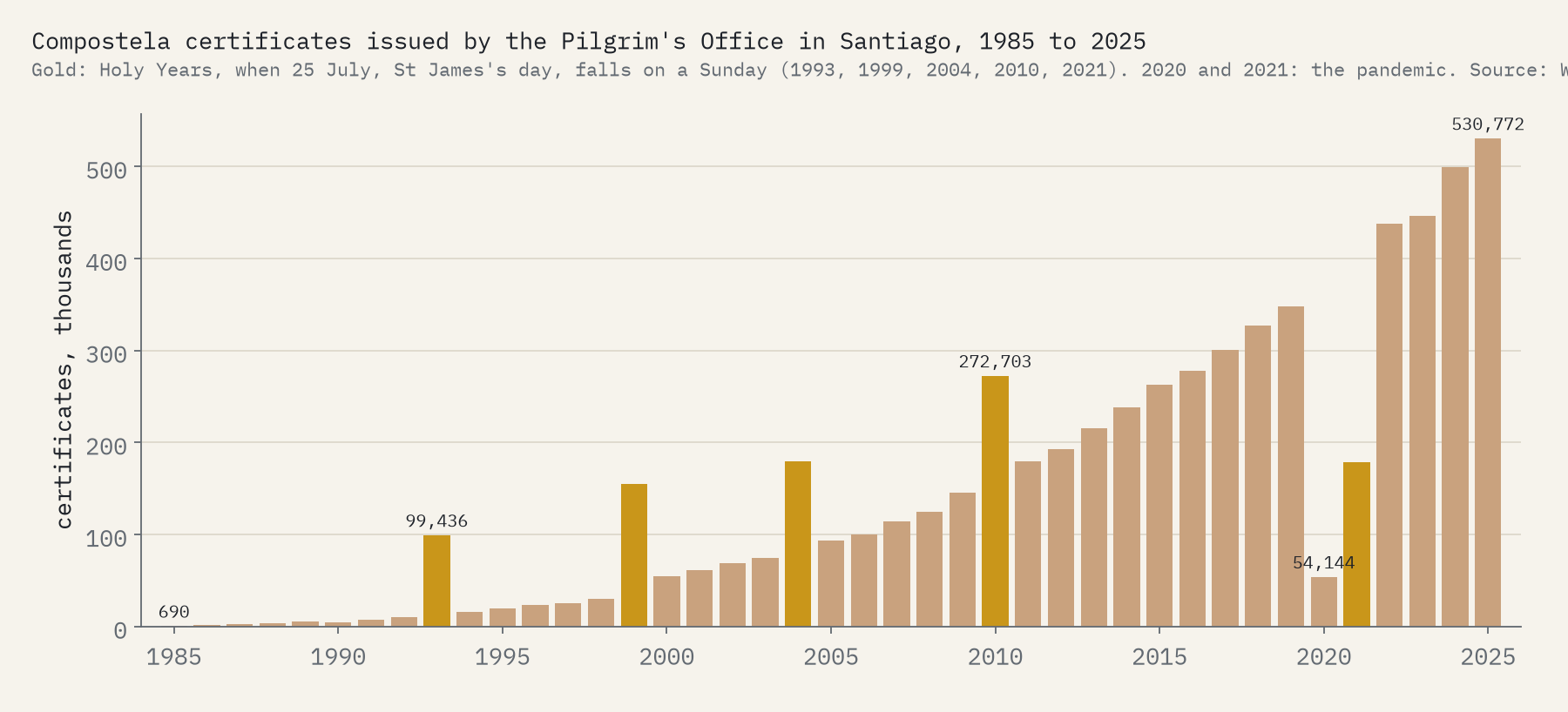
In 1985 the Pilgrim’s Office in Santiago de Compostela gave its certificate of completion, the Compostela, to 690 people. In 2025 it gave 530,772. The revival of the Camino is one of the great travel stories of the last forty years, and it has not stayed in Spain. All over Europe, St James societies, hiking clubs and parishes have waymarked routes with the scallop shell, and volunteers have drawn many of them into OpenStreetMap, the free map of the world, tagged as pilgrimage routes. Alongside them sit the Via Francigena to Rome, the St Olav Ways to Trondheim and hundreds of smaller pilgrim paths.
I took 1,906 of those route relations, split them into tiny segments and counted each segment once, because the same path often belongs to a stage, a longer route and a cycling version at the same time. The naive total is 83,037 km; without the double counting it is 77,804 km.
More Jakobsweg than Camino
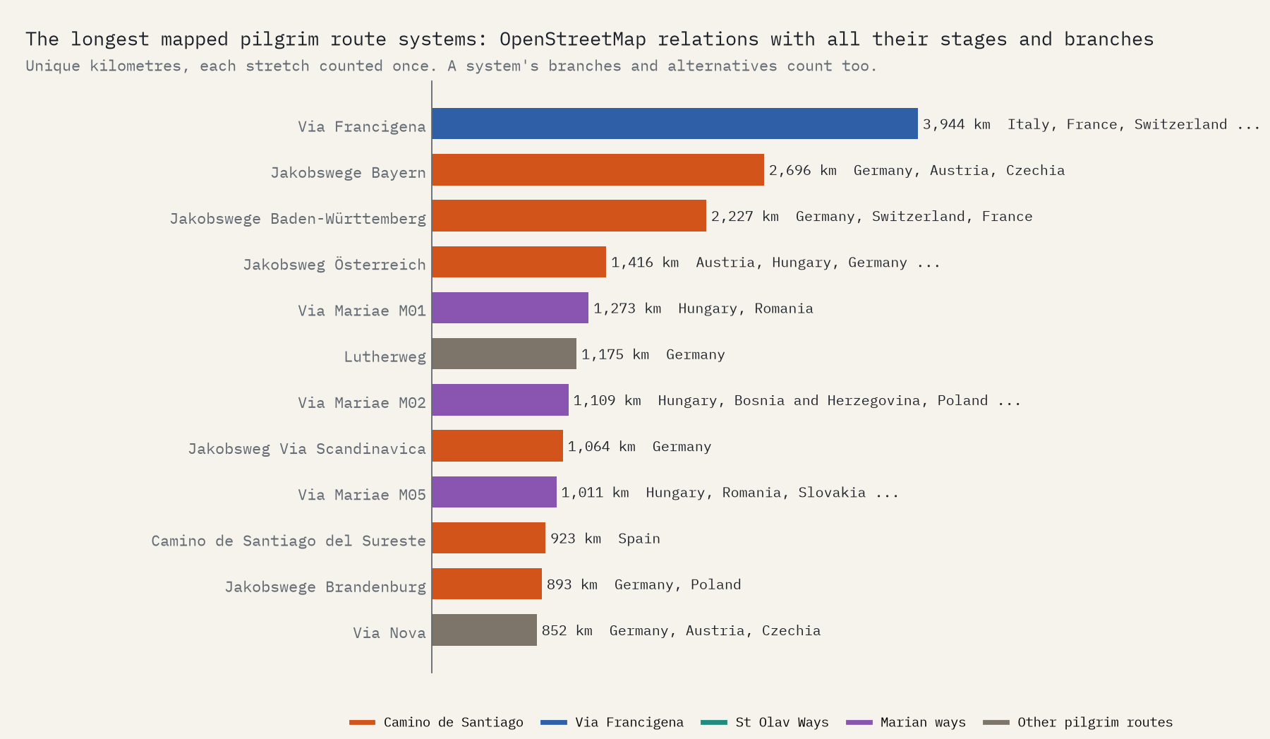
41,674 km of the routes are signed for Santiago, in 22 countries. Spain has 9,922 km of them. Germany has 14,814 km of Jakobswege, 1.5 times as much, and Poland 5,289 km of Drogi św. Jakuba. Bavaria’s network alone runs to 2,696 km.
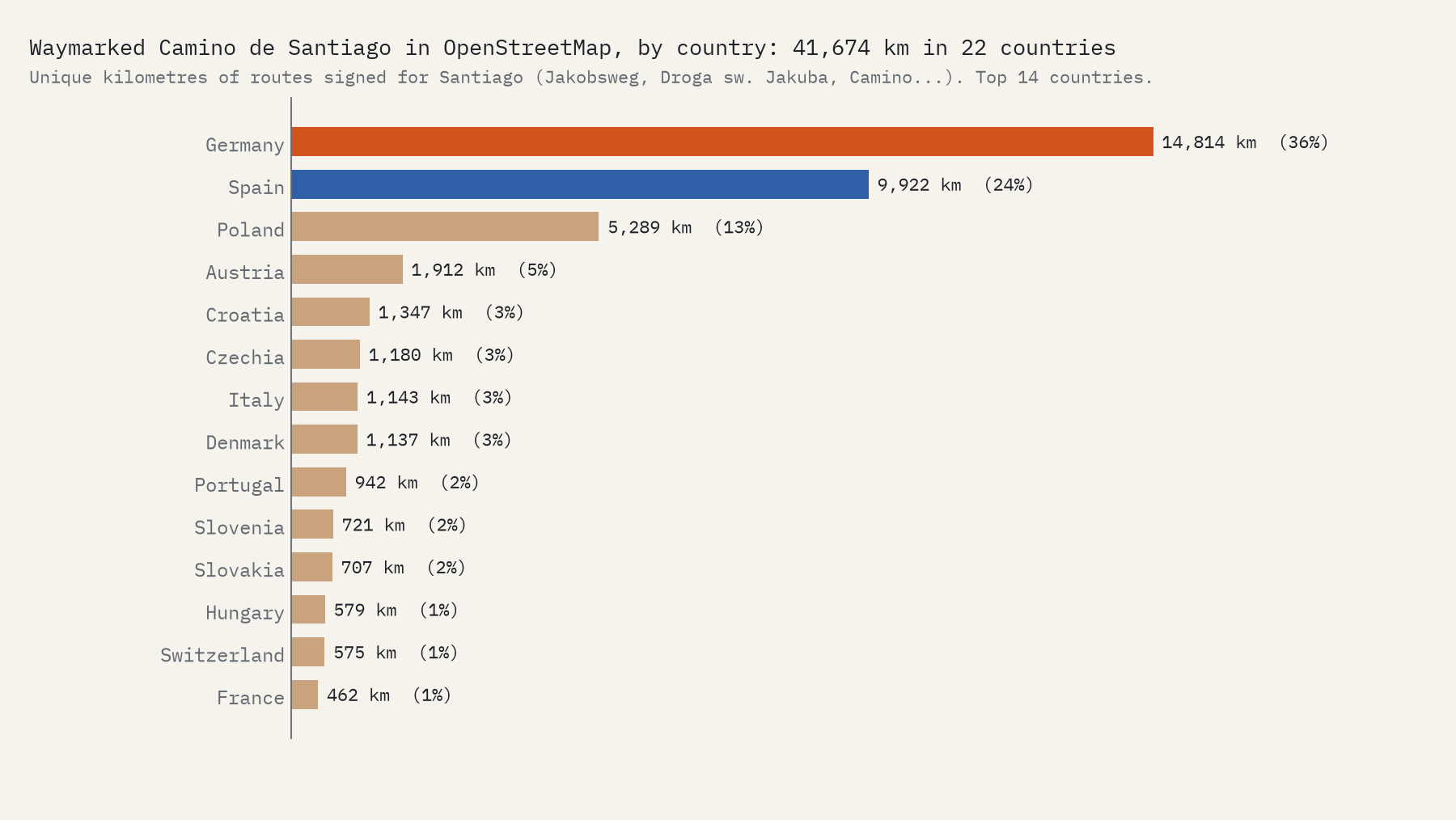
Two cautions. This measures what is waymarked and mapped, not where people walk: in 2024, 32% of certificate holders started at Sarria, on the last stretch of the Camino Francés. And France, with only 462 km, is badly undercounted. Several of its great routes, the Via Turonensis and the Via Tolosana among them, are missing from my download, and others are probably mapped as hiking trails without a pilgrimage tag.
All roads lead to Santiago, eventually
Measure each kilometre of Camino by its straight line distance from the cathedral and the shape of the network appears. Only 13% lies within 500 km of Santiago. Half of it is more than 1,659 km away, and the busiest band, 1,500 to 2,000 km, holds 41%, mostly in Germany, Austria and Croatia. The farthest waymarked stretch is the Camino Podolico in Ukraine, 2,911 km from the tomb of St James as the crow flies.
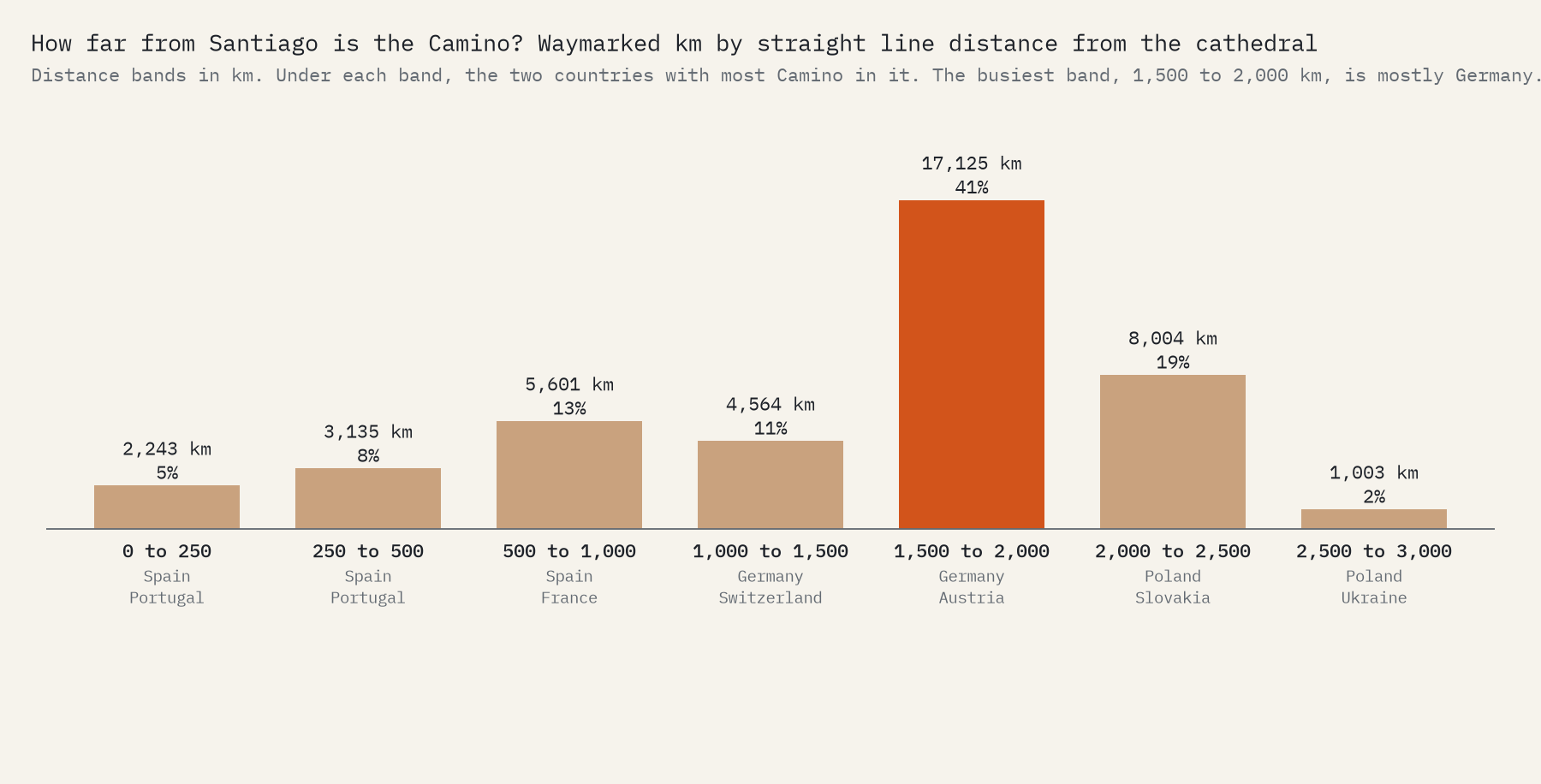
74% of the waymarked Way of St James is more than 1,000 km from Santiago.
To Rome, to Trondheim, to Mary
The rest of the map falls into a few families. The Via Francigena, the medieval road from Canterbury to Rome that Archbishop Sigeric described around 990, has 5,120 km, 74% of it in Italy, and with its variants and its extension south of Rome it is the longest single system in the data, 3,944 km. The St Olav Ways to Nidaros Cathedral in Trondheim have 3,011 km in Norway and Sweden. The Marian ways, mostly the Via Mariae network centred on Hungary, have 6,750 km. Everything else, from Germany’s Lutherweg to the roads to Assisi, adds 22,862 km.
Where pilgrims go
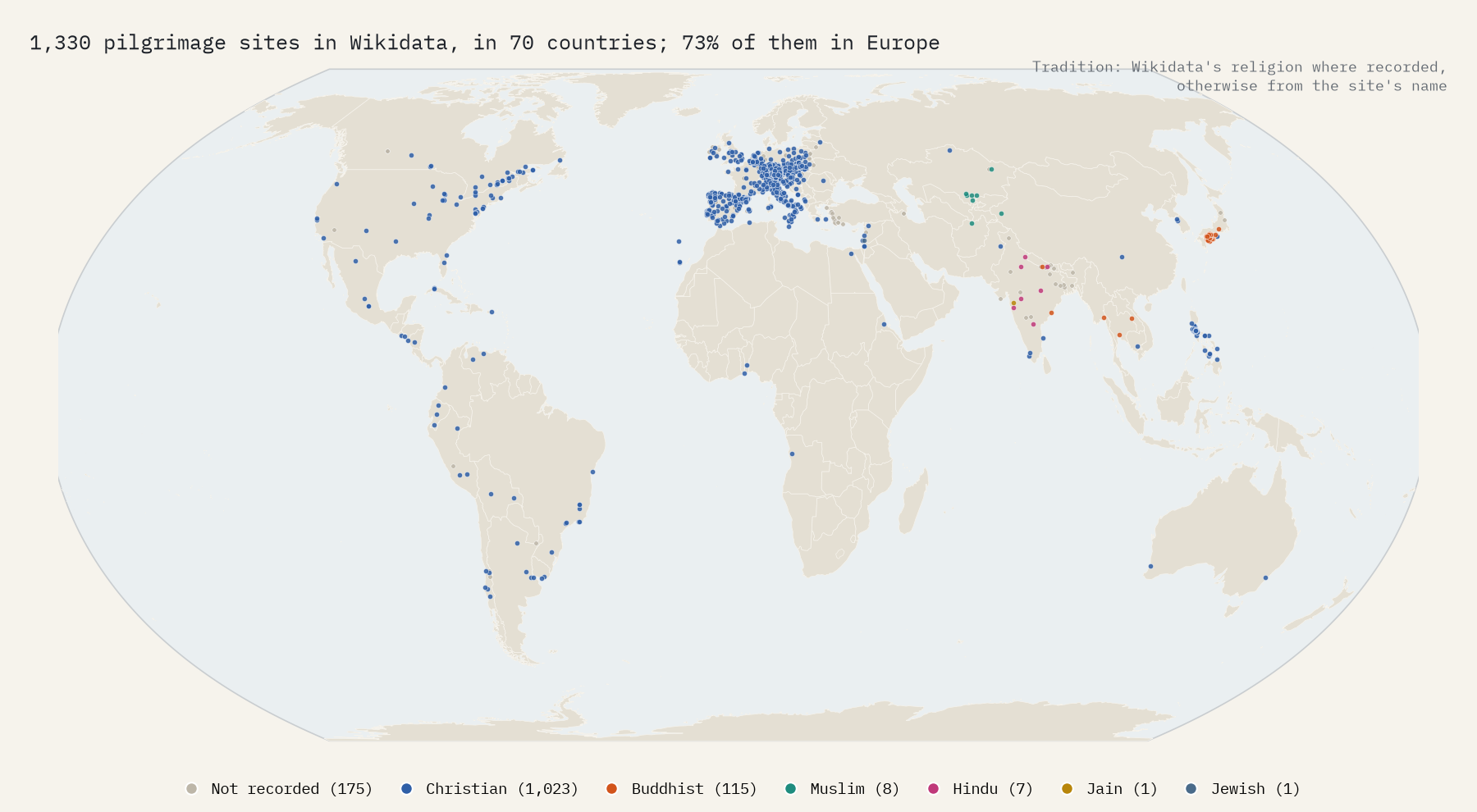
Wikidata lists 1,330 pilgrimage sites in 70 countries. Germany has the most (239, mostly pilgrimage churches), then Italy (225), Spain (163) and Japan (114), where 108 sit on Shikoku, the island of the 88 temple pilgrimage. Per head, Austria leads with 5.4 per million people. Where Wikidata records a religion, 94% of sites are Christian, but it records one for only 51% of them.
How many walk
The certificate counts tell the story of the revival: 99,436 in the Holy Year of 1993, 272,703 in 2010, a pandemic collapse to 54,144 in 2020 and a record 530,772 in 2025. The next Holy Year, when St James’s day falls on a Sunday, is 2,027.
What the map leaves out
This is a map of what volunteers have drawn, and they have mostly drawn Europe: 99.2% of the route kilometres. The biggest pilgrimages on Earth are missing entirely. The Hajj drew 1,707,301 pilgrims to Mecca in 2026, the Arba’een walk to Karbala draws ten to twenty million people a year, and about 660 million attended the Kumbh Mela in 2025, yet none appears as a mapped route. Even in Europe the download is incomplete: 100 of 2,028 relation ids failed, and the Camino Francés into Santiago itself is among the missing pieces. Every total here is a lower bound.
How I did this
The routes are OpenStreetMap relations tagged as pilgrimage routes, downloaded through the Overpass API. I left out a road, a bus route, a ski piste and a handful of trails tagged by mistake, split every way into point to point segments with coordinates to about 10 m, and counted each segment once. Families come from simple rules on route names in many languages, Wikidata links and the scallop shell symbol; stages inherit the family of their route. Countries come from Natural Earth outlines, distances from Santiago are straight lines, and the sites come from Wikidata. The certificate counts and historical facts come from Wikipedia. The paper sets out every step and caveat.
Notes and sources
- Route data © OpenStreetMap contributors, Open Database License (ODbL). Derived route data is released under the ODbL.
- Pilgrimage sites and pilgrim route items: Wikidata (CC0).
- Wikipedia, Way of St. James, Via Francigena, Shikoku Pilgrimage, St. Olav’s Way, Hajj, Arba’een Pilgrimage and Kumbh Mela, CC BY-SA 4.0, for facts and the certificate counts.
- Natural Earth country outlines (public domain).
- I wrote the text, with drafting and editing assistance from Claude (Anthropic), which also helped prepare the analysis code. I reviewed and checked all text and results.

