
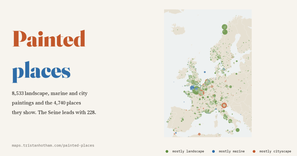
Where do landscape paintings look? I mapped 8,533 landscape, marine and city paintings catalogued in Wikidata, and the 4,740 real places they show: the rivers and towns painters returned to, and how far from home they went.
Wikidata, the free knowledge base behind Wikipedia, has records for an enormous number of paintings, many added by museums from their own catalogues. Some of those records say what a painting shows, and when that is a real river, town or mountain, it comes with a position on the map. I took every painting Wikidata calls a landscape, a marine (sea) painting or a cityscape that depicts such a place. After weeding out the things that have coordinates but are not places (more on that below), that leaves 8,533 paintings by 2,393 named painters, showing 4,740 places in 102 countries.
The most painted place is a river
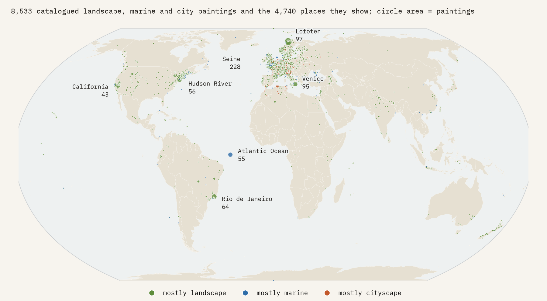
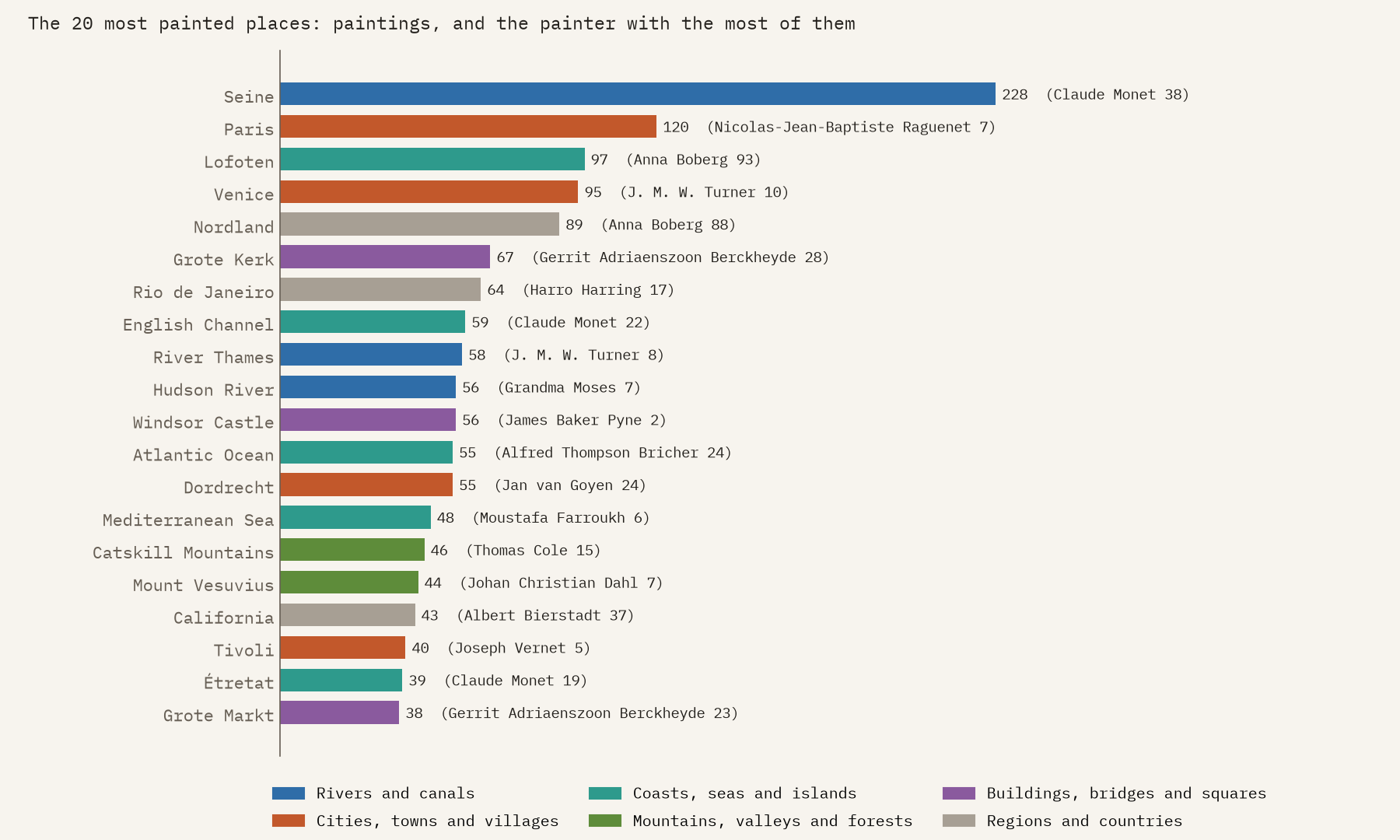
Top of the list is the Seine, with 228 paintings by 81 painters. Three Impressionists account for over a third of them: Claude Monet (38), Alfred Sisley (27) and Camille Pissarro (15). Then come Paris (120), Lofoten in arctic Norway (97), Venice (95) and Nordland, the Norwegian county around Lofoten (89). Water runs through the whole list: 8 of the 25 most painted places are rivers, coasts or seas, from the Thames and the Hudson to the cliffs of Étretat.
Home ground
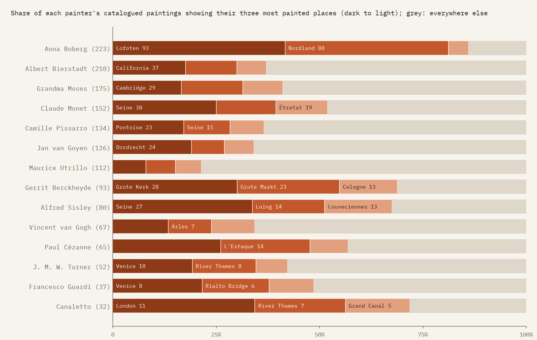
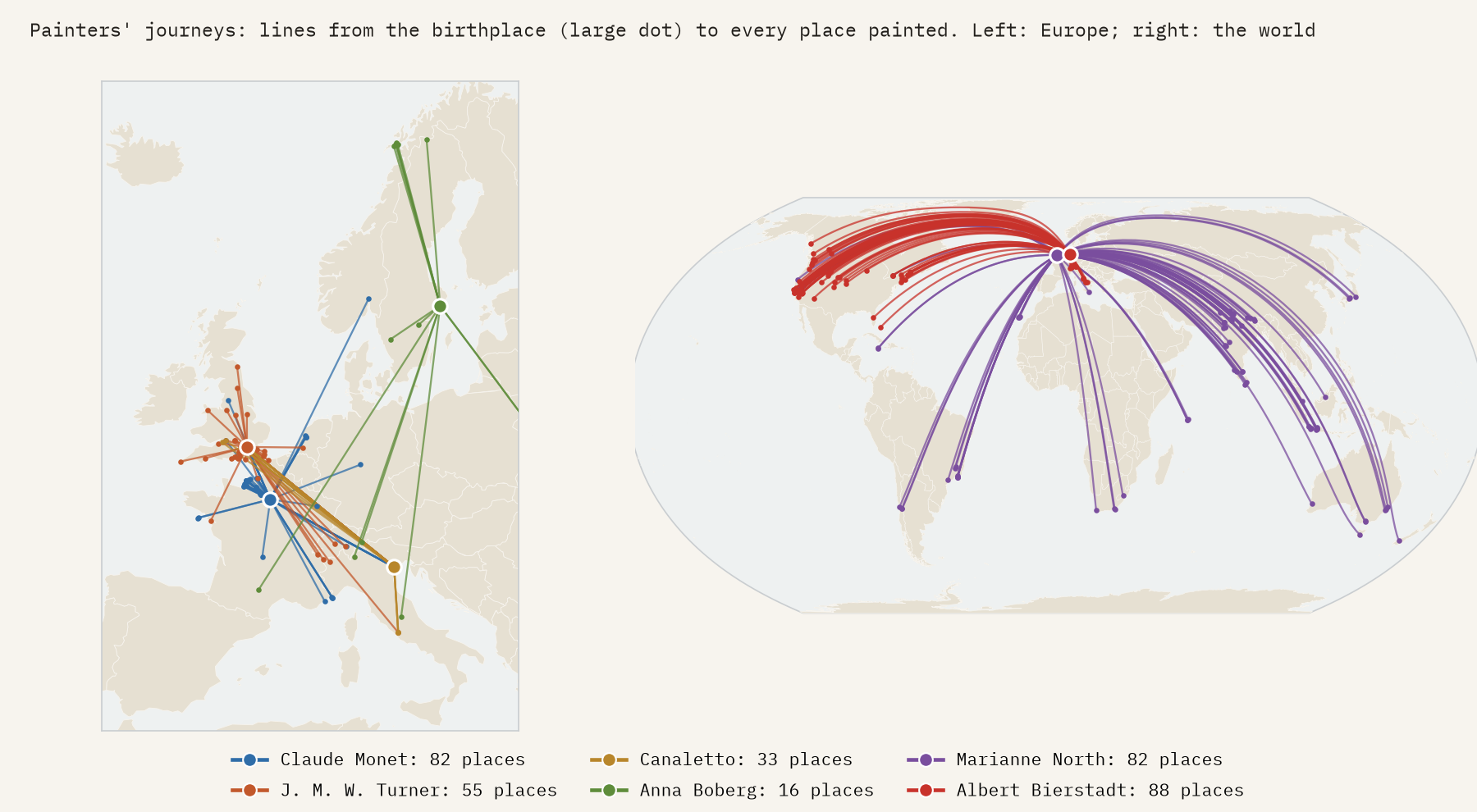
Many painters had one place they kept coming back to. The Seine is in 38 of Monet’s 152 catalogued paintings, the Montagne Sainte-Victoire in 17 of Cézanne’s 65, and Dordrecht in 24 of Jan van Goyen’s 126. Turner is the opposite: 56 different places in 52 paintings, with Venice ahead of the Thames. And Canaletto, the great painter of Venice, is in the catalogue almost as much for London: 13 of his 32 paintings here show London and the Thames, 15 show Venice.
How far from home?
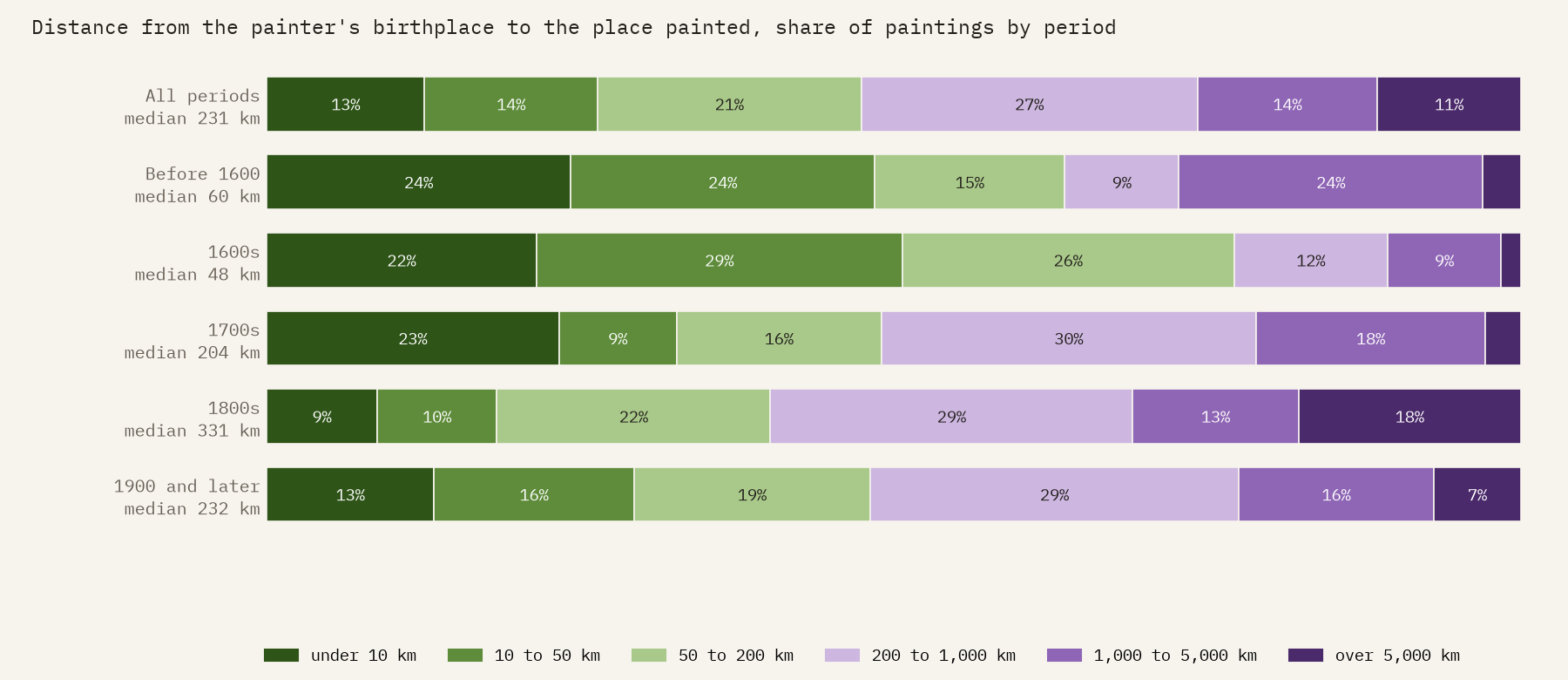
Wikidata also records where most painters were born, so I measured the distance from each painter’s birthplace to the places they painted. For 7,183 paintings the median is 231 km. A quarter (26%) show somewhere within 50 km of the painter’s birthplace, and another quarter (26%) somewhere more than 1,000 km away.
The 1600s were the century of the painted home town: half of the paintings show a place within 50 km of where the painter was born, and the median distance is just 48 km. That is the Dutch golden age, painters painting their own towns, churches and rivers. By the 1800s the median is 331 km and 31% of paintings show places more than 1,000 km from the painter’s birthplace. Marianne North, the English botanical painter, has a median of 8,467 km across 20 countries. Not every long distance is a journey, though: Albert Bierstadt was born in Germany and made his career painting the American West, and Pissarro was born in the Caribbean.
From Dutch towns to French rivers
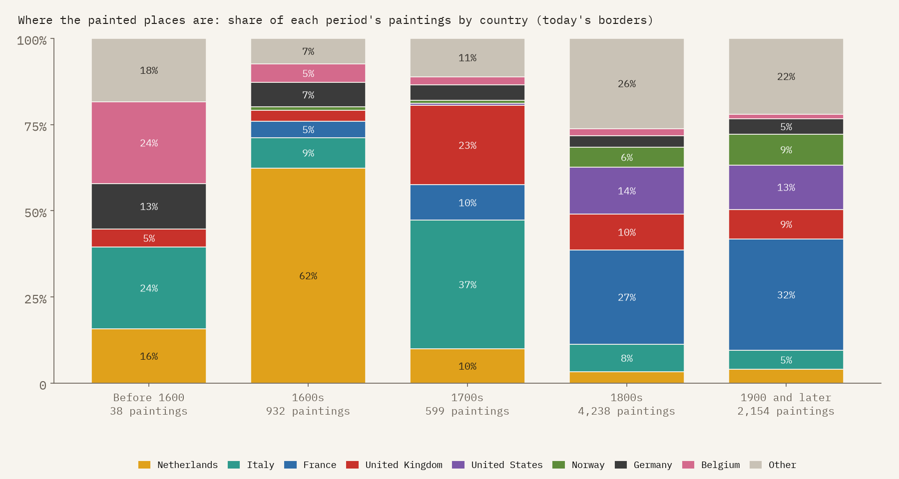
The places change with the centuries. In the 1600s, 62% of the paintings show what is now the Netherlands. In the 1700s Italy leads with 37%, the Venice of Canaletto and Guardi and the Rome and Tivoli of the Grand Tour, with Britain second. In the 1800s France takes over (27%) and the United States appears (14%). Norway grows from about 1% before 1800 to 9% after 1900.
A map of catalogues
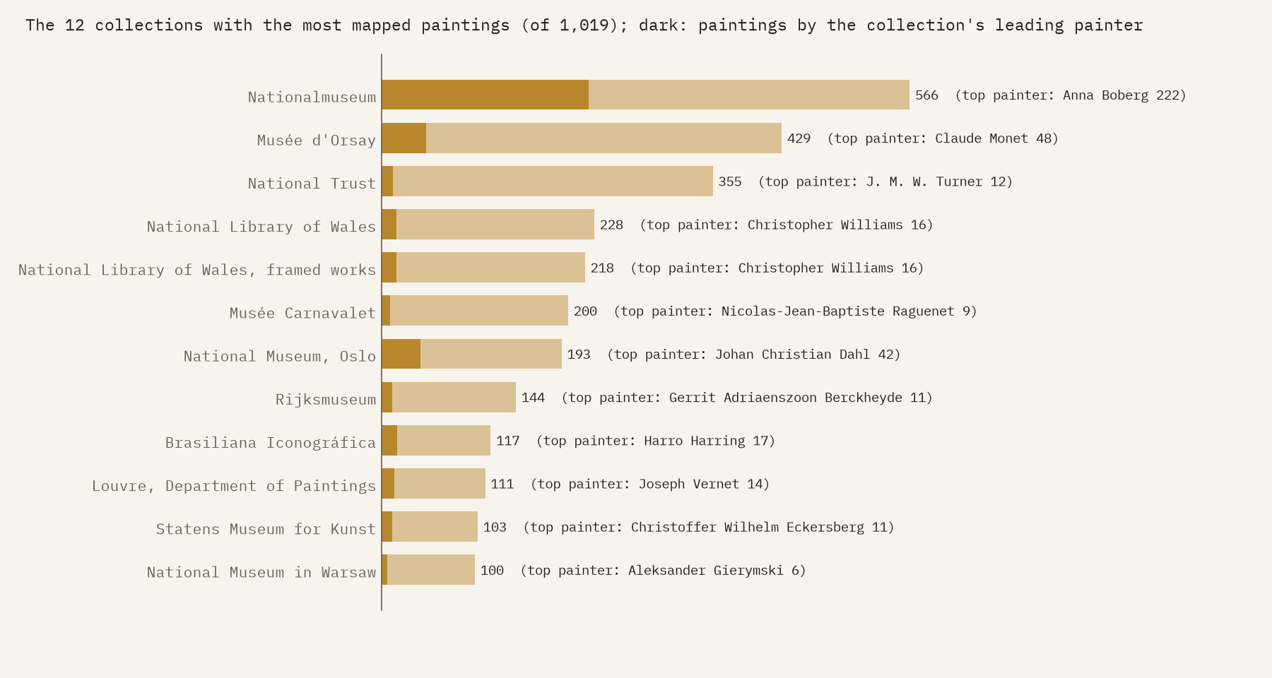
Why are Lofoten and Nordland in the top five? Because Sweden’s Nationalmuseum has catalogued 222 paintings by one painter, Anna Boberg, who went north to paint them again and again. That one collection holds 6.6% of every mapped painting. The same thing happens elsewhere: Windsor Castle’s paintings are mostly in the National Trust, every painting of the state of Rio de Janeiro comes from one Brazilian image library, and Grandma Moses’s 175 paintings put the small town of Cambridge, New York, in the top 30. The ten biggest collections hold 30% of the paintings, and 80% of all paintings show places in Europe. So this is a map of what museums and volunteers have described in detail, as much as of where painters went.
How I did this
I queried Wikidata on 1 November 2026 for paintings with a landscape, marine or cityscape genre that depict something with coordinates. “Depicts” catches more than places, so I removed 94 depicted items that are not places on the Earth: the Moon (which has its coordinates on the lunar globe and appears in 138 moonlit scenes), 70 events such as sea battles and fires, and 19 ships. Distances run from the painter’s birthplace to each place, leaving out paintings that name only a country, region or sea. Countries are today’s. The full method, the list of exclusions and the caveats are in the paper and the code.
Notes and sources
- Wikidata, queried through QLever on 1 November 2026. CC0.
- The interactive map shows thumbnails from Wikimedia Commons, each under its own licence. The images in this post are my own charts and maps.
- Natural Earth country outlines (public domain).
- I wrote the text, with drafting and editing assistance from Claude (Anthropic), which also helped prepare the analysis code. I reviewed and checked all text and results.

