
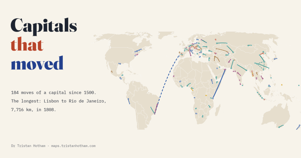
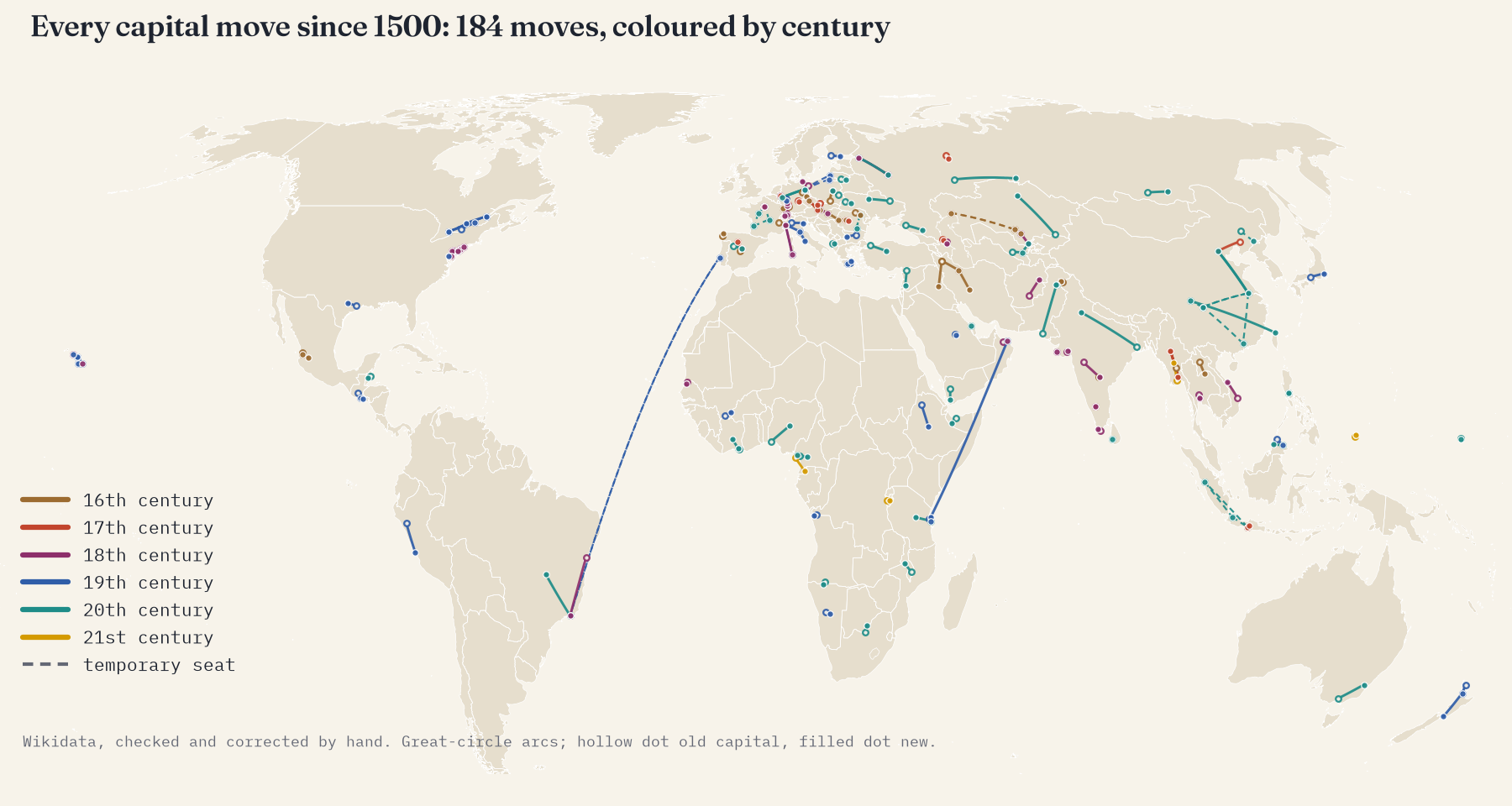
Capitals feel permanent, but they move more often than you might think. I mapped every move of a capital since 1500 that the open record knows about, checked the famous ones by hand, and found 184 moves: from Moscow to a new city on the Neva, from Lisbon across the Atlantic, and from coastal ports to brand-new cities in the interior.
Ask most people to name a capital that moved and they will say Brasília, or perhaps Canberra. Both are good answers. Brazil built Brasília on an empty plateau in about four years and moved there from Rio de Janeiro in 1960; Australia’s parliament first sat in Canberra in 1927, after a quarter of a century in Melbourne. But the list goes on much further than that: Abuja, Islamabad, Naypyidaw, Astana, Dodoma, Yamoussoukro, Gitega. And in January 2026 Equatorial Guinea moved its capital from Malabo, on an island, to Ciudad de la Paz, a planned city in the mainland forest.
I wanted to see them all at once, as arcs on a map from the old capital to the new. Wikidata, the open database behind Wikipedia, records the capitals of thousands of states with the years each held the role, so in principle the arcs can be read straight out of it. In practice it took a lot of checking, which turned out to be half the story.
A restless 20th century
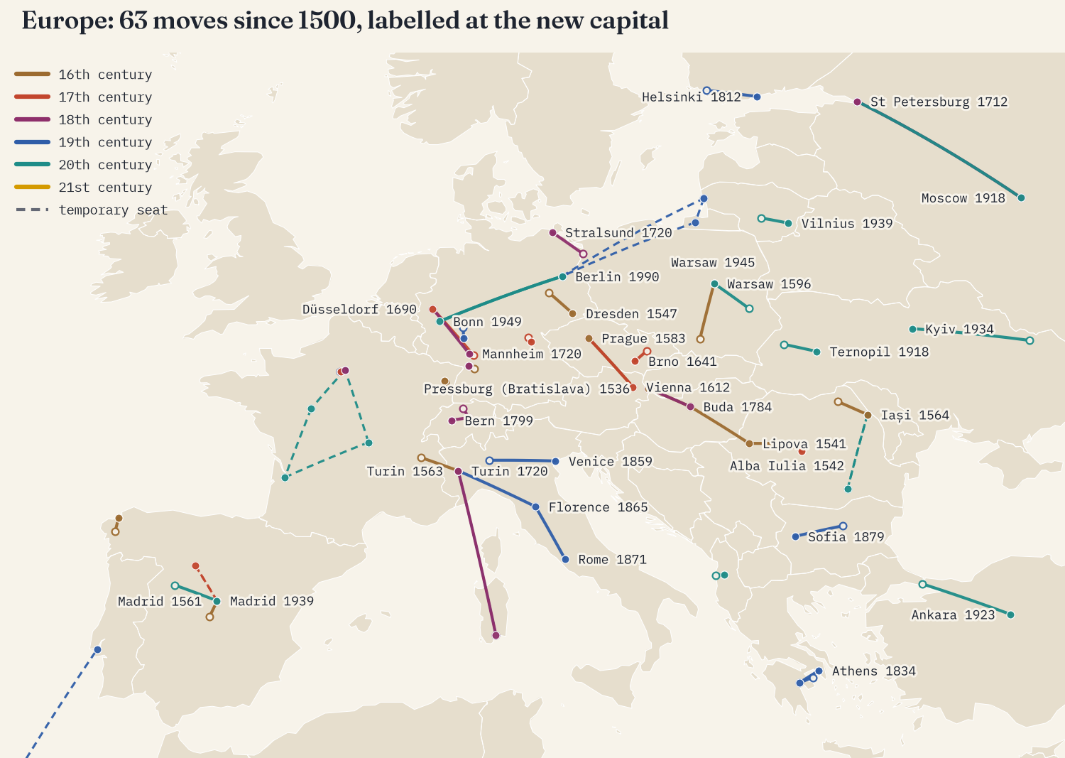
Since 1500 I count 184 moves by 114 states: 136 that lasted and 48 temporary ones, seats taken up in wartime or a crisis, or moves that went back within ten years. The 20th century is the busiest, with 59. Some were born of revolution and war: the Bolsheviks left Petrograd for Moscow in 1918, Atatürk’s new republic made Ankara its capital in 1923, and in 1949 the Republic of China fled from Nanjing to Guangzhou, Chongqing, Chengdu and finally Taipei in a single year. Others were careful plans, decades in the making.
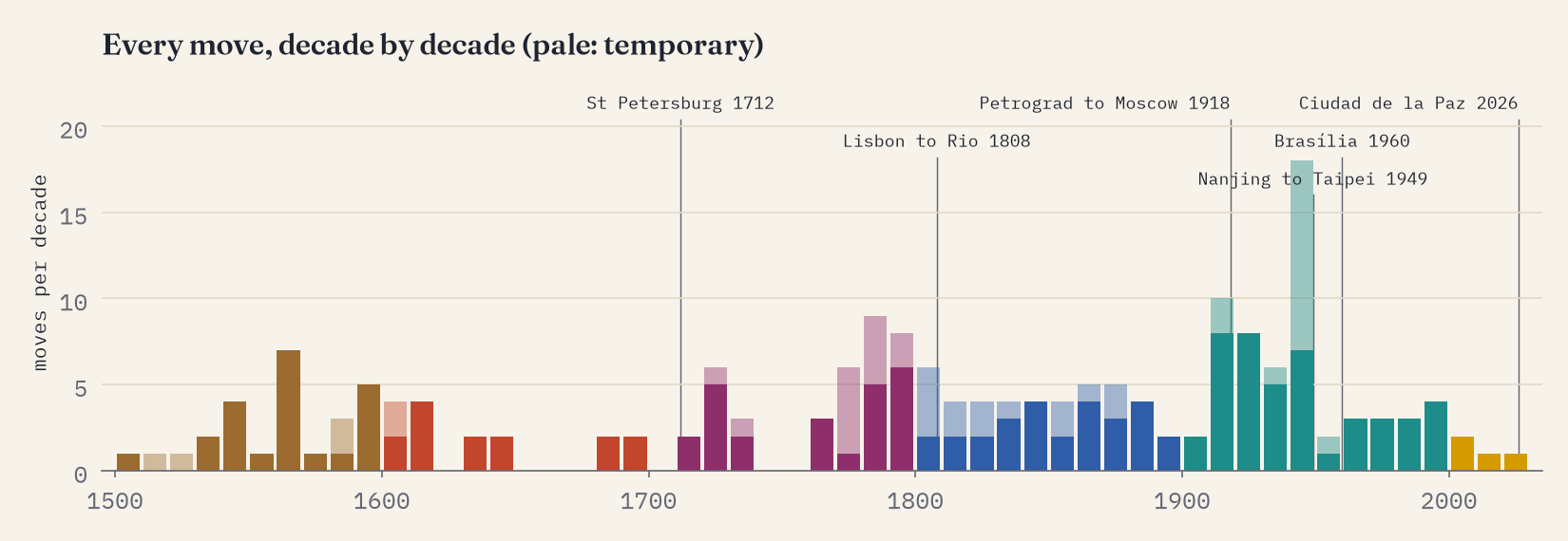
The quieter early centuries are partly real and partly an artefact. Wikidata knows an astonishing amount about the small German principalities of the 17th and 18th centuries, which moved their courts a few kilometres to a new palace, and far less about Africa, Asia and the Americas before colonial rule.
Across the street, and across an ocean
Most moves are short. The median lasting move is 177 km, and 36% of them covered less than 100 km. My favourite is the shortest: in 1782 King Rama I moved his capital from Thonburi across the Chao Phraya river to the village of Bangkok, 4 km away.
At the other end is a flight. In November 1807, with Napoleon’s army marching on Lisbon, the Portuguese royal family, the government and thousands of courtiers boarded ships for Brazil. From 1808 the Portuguese empire was ruled from Rio de Janeiro, 7,716 km away: the only time a European power was governed from one of its colonies. King João VI went home in 1821. The longest move that lasted is the Sultan of Oman’s: in 1840 Said bin Sultan moved his capital 3,924 km from Muscat to Stone Town on Zanzibar, the hub of his trade in cloves, ivory and enslaved people.
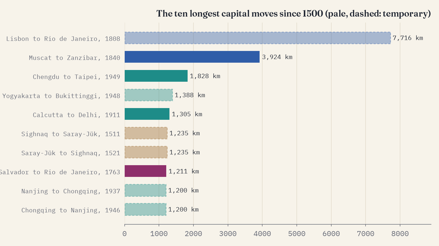
For thirteen years a European empire was ruled from Rio de Janeiro, 7,716 km from Lisbon: the longest capital move since 1500.
Built from nothing, and away from the sea
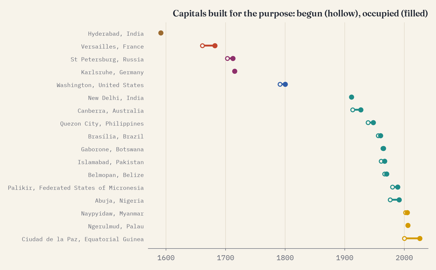
17 of the moves went to a capital that was built, or laid out as a new town, for the purpose. The idea is old: Peter the Great founded St Petersburg in 1703 and moved his court there in 1712, and the margraves of Baden laid out Karlsruhe in 1715 as a fan of streets around their palace. But 12 of the 17 came after 1900, when building a capital became a way of building a nation: New Delhi, Canberra, Brasília, Islamabad, Belmopan, Gaborone, Abuja, Naypyidaw, Ciudad de la Paz.
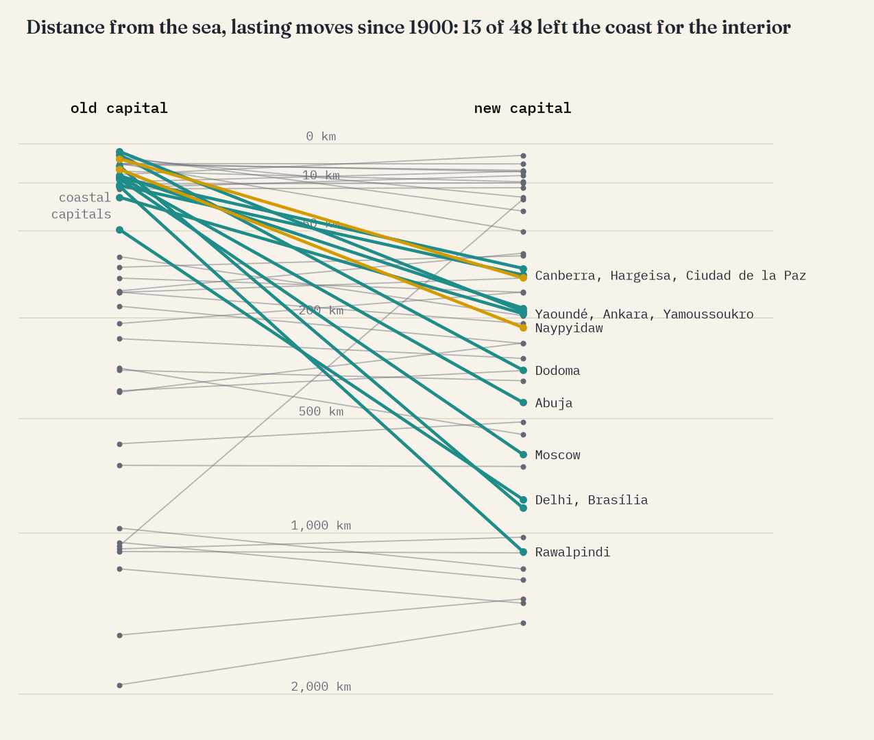
Many of the modern moves have something else in common: they left the coast. Of the 48 lasting moves since 1900, 13 (27%) left a capital within 50 km of the sea for one at least 50 km inland, against 8% before 1900. Rio to Brasília, Lagos to Abuja, Dar es Salaam to Dodoma, Yangon to Naypyidaw, Abidjan to Yamoussoukro, Karachi to Islamabad, Malabo to Ciudad de la Paz: a port built for trade, often under colonial rule, gives way to a capital in the middle of the country. Brasília is 916 km closer to Brazil’s centre than Rio. Only one move went the other way, the Republic of China’s retreat to Taipei.
The restless and the missing
Counted by present-day country, the United States has the most moves, 17, though only 5 lasted. Eleven belong to the young republic: the Continental Congress fled the British to Baltimore, Lancaster and York, was chased out of Philadelphia in 1783 by soldiers demanding their pay, and met in Princeton, Annapolis, Trenton and New York before Philadelphia and, in 1800, Washington. Germany comes next with 12, almost all of them small German courts, then India and China.
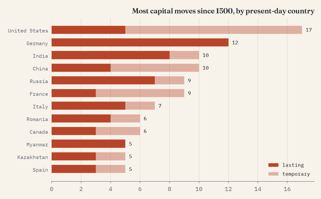
Those counts say as much about the record as about restlessness. 81% of today’s sovereign states have just one capital in Wikidata, and some famous moves are simply not there. Turkey’s entry starts with Ankara in 1923, with no Istanbul before it. Japan’s has no move from Kyoto to Tokyo. Canada’s has no Kingston, Montreal, Toronto or Quebec City, though its parliament moved between them for 25 years before settling in Ottawa. Other moves are there but wrong: the order misread, the seat of a court taken for the capital, the same move recorded twice with different years.
So I checked the moves people know best and anything that looked odd, against cited sources, and wrote every decision down: 45 automatic moves removed, 5 corrected, 22 confirmed and 42 added. The edits file is part of the data, and I hope someone uses it to fix Wikidata.
Still moving: Nusantara
The move everyone asks about is Indonesia’s, from Jakarta to Nusantara in East Kalimantan, 1,240 km away. As of 2026 it has not happened. A 2022 law names Nusantara as the capital, but the transfer takes effect only when the president signs a decree, and none has been signed. In May 2026 Indonesia’s Constitutional Court confirmed that Jakarta remains the capital until then; the government’s stated aim is to make Nusantara a “political capital” by 2028. On the map it is a dotted grey arc, drawn but not counted.
How I did this
I took every capital statement in Wikidata for countries, sovereign states, historical countries, kingdoms, empires and republics, with its start and end years: 2,978 statements for 2,295 states, of which only 21.3% have a date. A move is read where one capital’s time ends and another’s begins within two years, or where only one side is dated and the other city runs on; joint capitals, renamings (Edo to Tokyo, Constantinople to Istanbul) and states with no dates at all are left out, and the same move on several items is counted once. That gave 202 candidate moves, which I then checked and corrected by hand as above. Distances are along the great circle between the two cities; distance from the sea is to the nearest ocean coast in Natural Earth. Every move has a confidence flag, and every hand edit its source. It is a map of what the record knows, richest for Europe, and not a complete history.
Notes and sources
- Wikidata capital (P36) statements with start and end times, CC0, via QLever.
- Hand checks, corrections and additions, each with its source (mostly English Wikipedia articles), in the edits file.
- Equatorial Guinea: africanews. Nusantara: The Star and The Jakarta Post.
- Natural Earth countries, land and places (public domain).
- I wrote the text, with drafting and editing assistance from Claude (Anthropic), which also helped prepare the analysis code. I reviewed and checked all text and results.

