
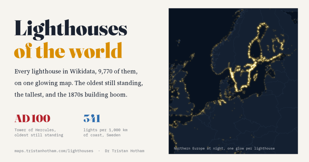
Wikidata knows of 9,770 lighthouses. I put every one of them on a map and switched them on. The coasts of the world draw themselves in light, the Victorians turn out to have built most of them, and the brightest coast of all belongs to Sweden, partly because Sweden wrote its lights down.
I have always had a soft spot for lighthouses. They are buildings with one job, done for strangers: a tower on the worst rock on the coast, so that nobody else has to be wrecked there. So I wanted to see all of them at once.
Wikidata, the free database that sits behind Wikipedia, has 9,770 lighthouses with a position, once I had taken out a few dozen keepers’ cottages and replicas that had crept in. 6,546 of them have a year when they were built or first lit. Give each one a soft glow on a dark map and this is what you get.
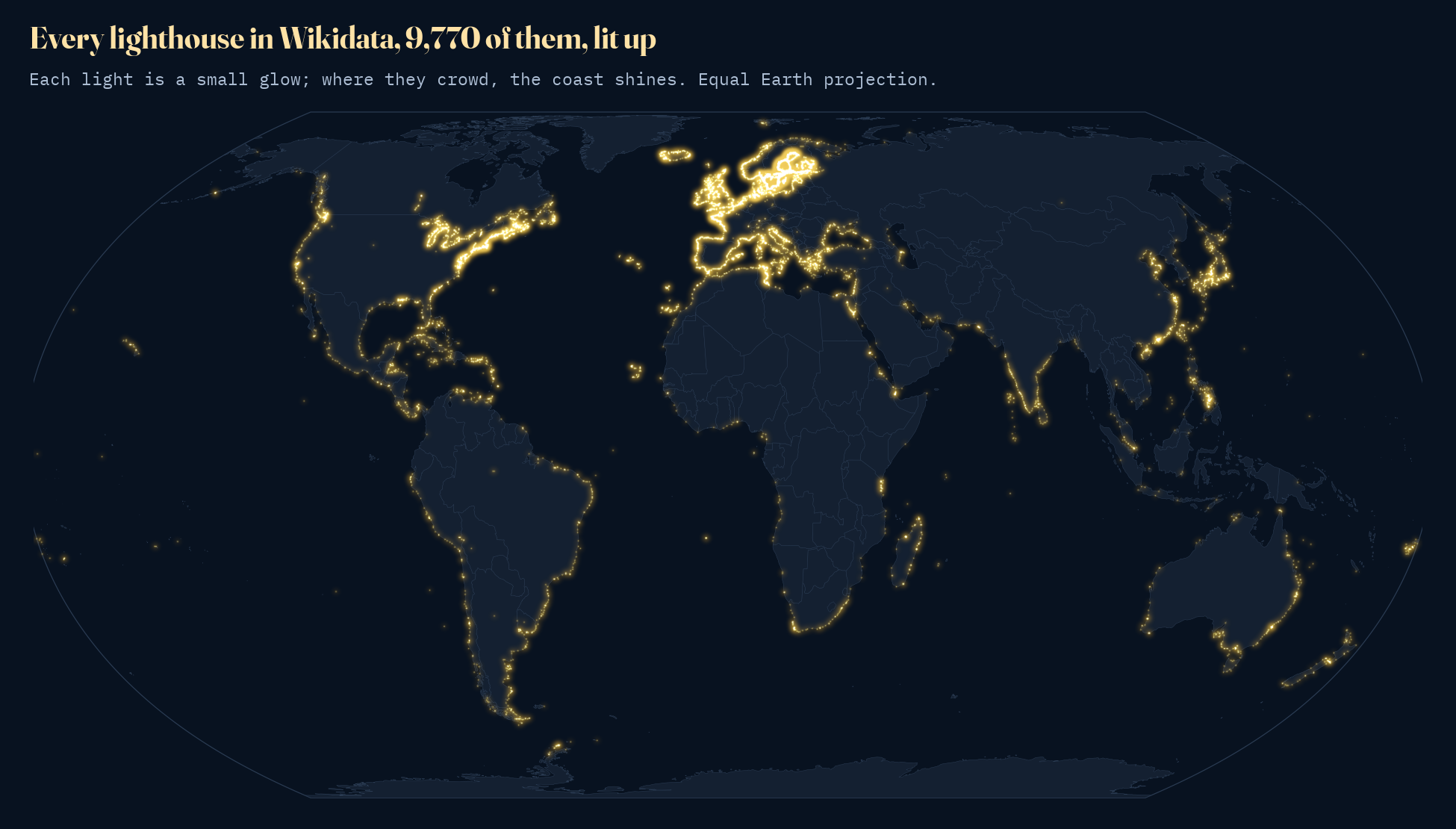
It looks like the Earth at night, and in a way it is: these are the lights a sailor would see. The North Atlantic is ringed with them. Japan and the Chinese coast are bright. Africa, much of South America and South and Southeast Asia are lit only here and there. Some of that pattern is real, the busy and dangerous seas of the industrial world, and some of it, as we will see, is about who has written their lights down.
The lighthouse century
Lighthouses are ancient, but most of the ones on the map are not. Only 144 of the dated lights were built before 1800. Then the industrial century arrived, with iron, steam, cheap glass, the Fresnel lens and a world trade that needed every headland lit. Outside Sweden, the number of new lights went from 103 in the 1820s to 376 in the 1870s, and it stayed above three hundred a decade until the First World War. The United States built most in the 1870s.
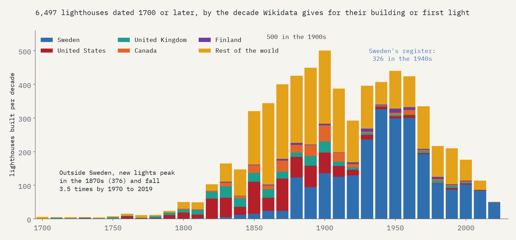
After the First World War the curve outside Sweden falls away: about 337 new lights a decade from 1850 to 1909, about 97 a decade from 1970 to 2019. The best sites were taken, and the work of a lighthouse was changing. Lights were automated through the twentieth century; in Britain the last keepers came ashore in 1998. Satellite navigation, fully working from the mid 1990s, now does much of what a light used to do. New lights tend to be small automatic beacons, and Wikidata rarely bothers with those.
Except in Sweden. Sweden has 2,555 lighthouses in Wikidata, 26% of the world’s total, and nearly all are dated. They peak in the 1940s, and from 1930 to 1969 Sweden alone supplies 70% of all the dated new lights in the database. Their recorded heights are small and 89% have no Wikipedia article. These look like the little automatic lights of the Swedish archipelagos, there because somebody loaded a whole national list. Other countries surely built similar lights; they just are not in the data.
Counting coast
A country with more coast needs more lights, so raw counts are only half the picture. I measured the coast of every country on Natural Earth’s 1:10m map, taking each country’s outline and removing the borders it shares with neighbours, and divided its sea lights by that length. The world has about 921,367 km of coast at that scale, and 9.4 lighthouses in Wikidata per 1,000 km of it.
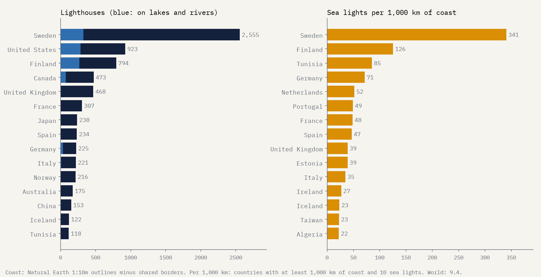
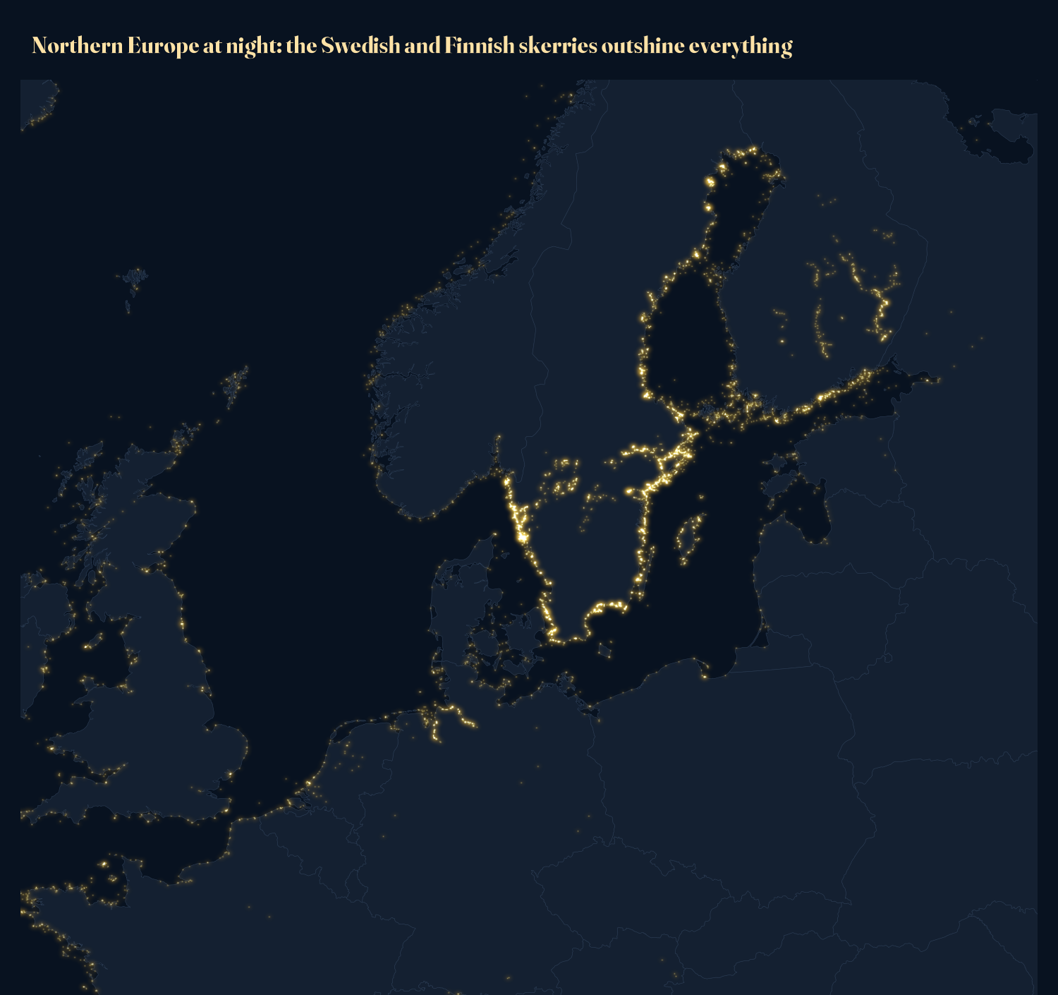
Sweden comes out top again, with 341 lights per 1,000 km, then Finland (126), Tunisia and Germany. France, Spain and the United Kingdom sit together between about 39 and 48. At the bottom are the giants with vast, broken coasts: Canada has 2.9 per 1,000 km and Indonesia 0.2. Indonesia has more than 12 lighthouses, of course. Wikidata does not.
Measuring coast is a famous trap: the closer you look, the longer it gets. At this scale the Swedish skerries and the Norwegian fjords are smoothed away, so the numbers compare countries fairly but are not the “true” length of anything.
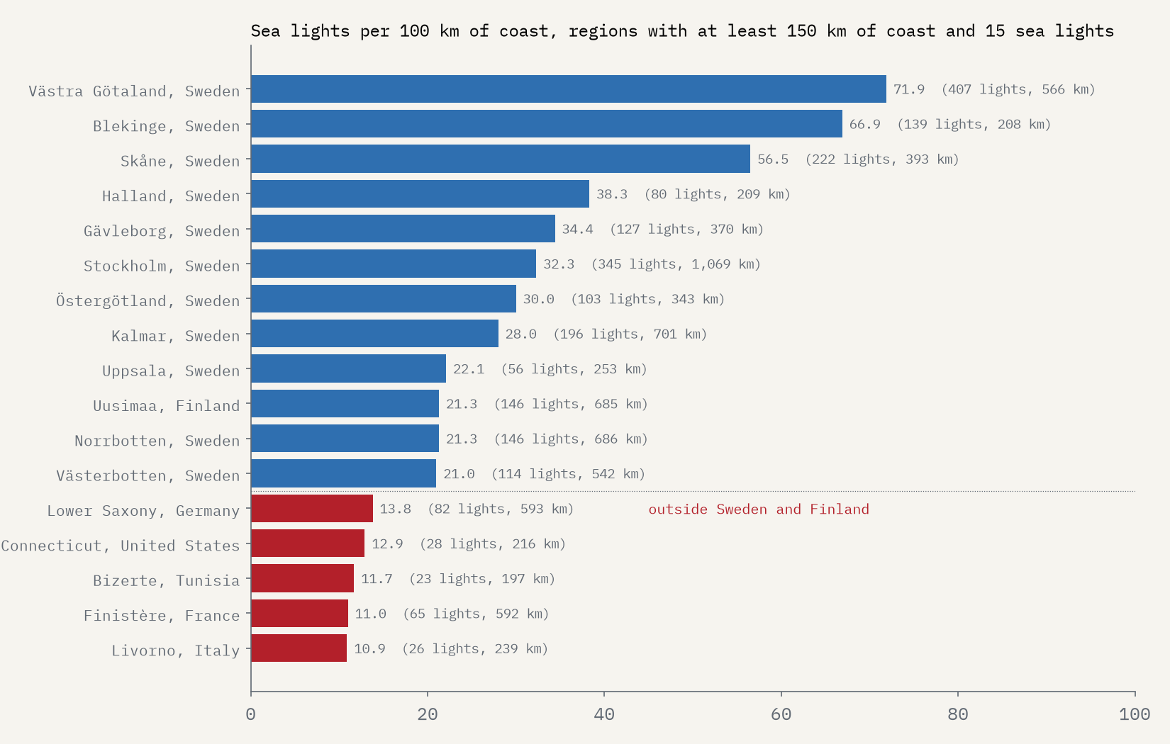
Doing the same for states, provinces and counties finds the most crowded coasts. All of the top ten are Swedish or Finnish, led by Västra Götaland on the Skagerrak with 71.9 lights per 100 km. Outside those two countries, the densest are Lower Saxony, on the shifting sandbanks of the Wadden Sea (13.8), and Connecticut, where Long Island Sound is lit like a street (12.9).
The oldest, and the tallest
The oldest date in Wikidata belongs to a lighthouse that is long gone: the Pharos of Alexandria, one of the Seven Wonders, dated 278 BC. The oldest still standing is the Tower of Hercules at A Coruña in Galicia, a Roman tower that Wikidata dates to AD 100 and which still shines over the Atlantic. The Romans also left the Dubris Pharos inside Dover Castle (AD 200), a ruin now. Then come the medieval towers: Hook Head in Ireland (1300 in Wikidata, a date that looks rounded to a century), Kõpu in Estonia (1531), Genoa’s Lanterna (1543) and Cordouan in the Gironde (1615).
Old dates need care. Wikidata usually gives the year a light was first shown on the site, and towers were rebuilt: the Planier light off Marseille carries a date of 1326, but its present tower went up in 1959. Whether a tower still stands is not in the data I used, so I checked the best known of the oldest by hand, and the interactive page says where I could not be sure.
A lighthouse map is a map of danger, of trade and of whoever wrote the lights down.
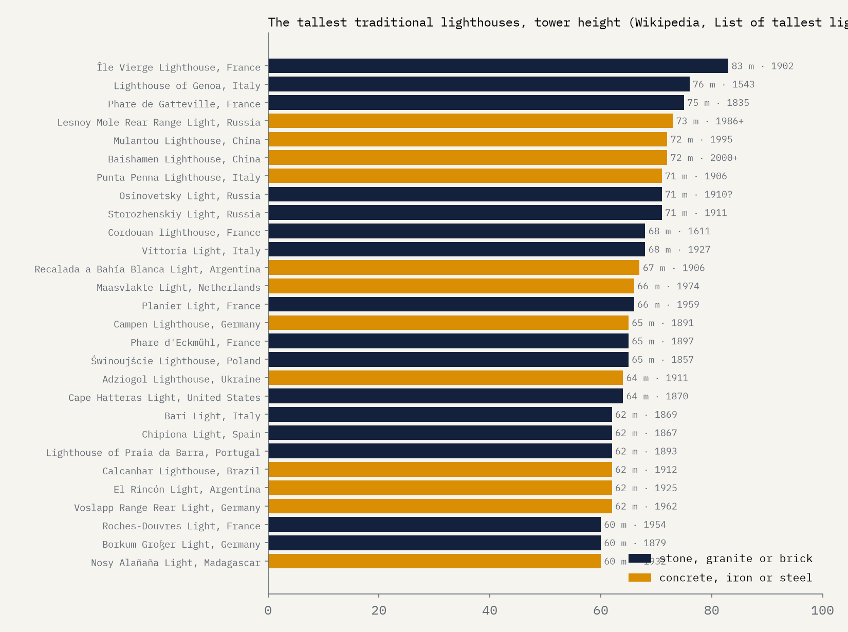
For height I used Wikipedia’s list of tallest lighthouses, because the heights in my Wikidata extract had lost their units: Cape Hatteras appears as 210, which is its height in feet. The tallest traditional lighthouse is the granite tower on the Île Vierge in Finistère, 83 m, finished in 1902. 16 of the 28 towers of 60 m or more are stone, granite or brick.
What the map cannot see
Wikidata’s coverage varies enormously from country to country. Some national lists have been loaded almost light by light, often without an English name or a Wikipedia article: 96% of Sweden’s lights have at most one article, as do 91% of Finland’s. Other countries are covered by volunteers writing one article at a time; in the United States only 16% of lights lack a second article. And some coastal countries have no lighthouse in Wikidata at all, Greenland, Nigeria, Kenya and Ecuador among them.
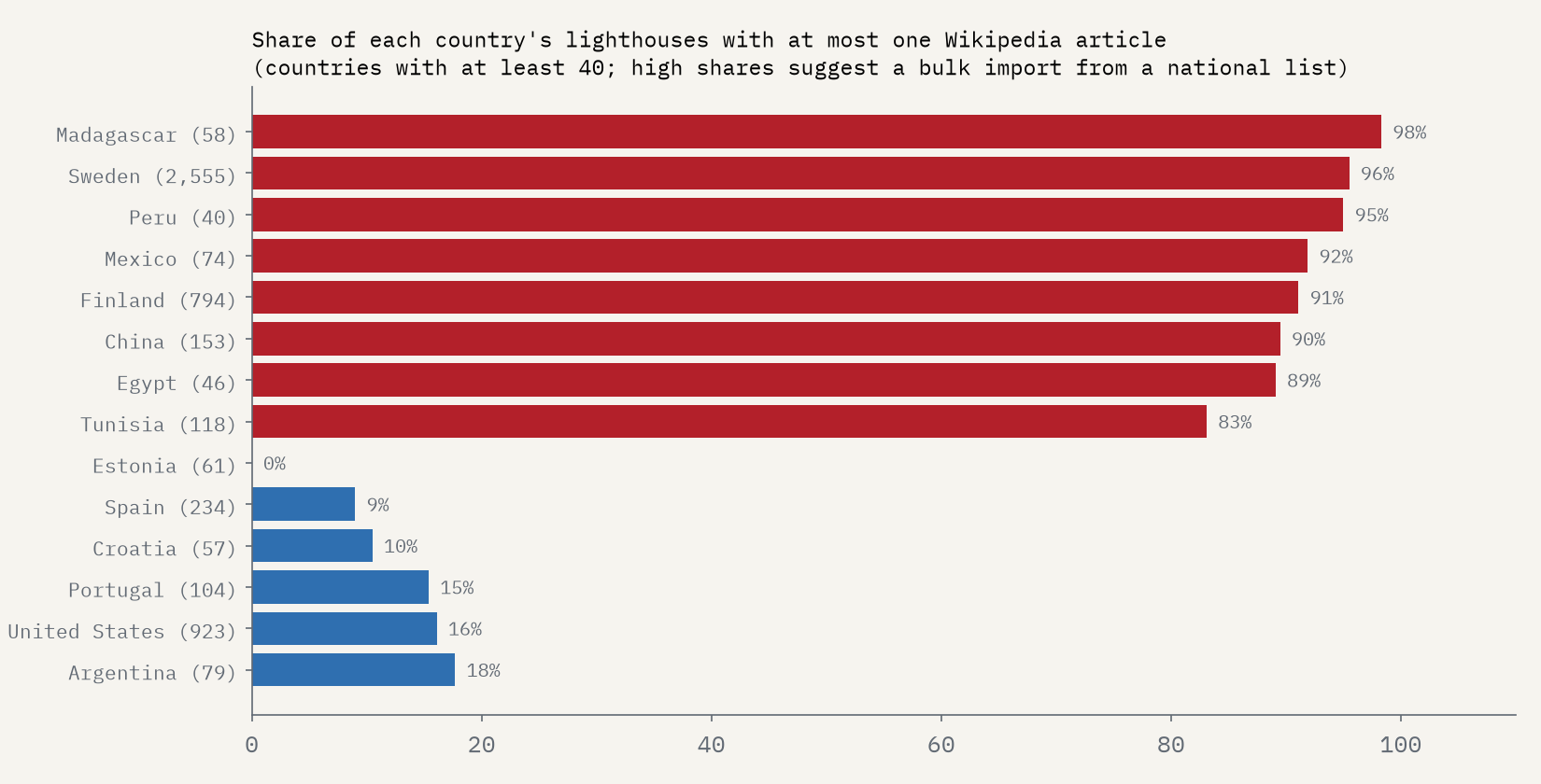
So the bright coasts on the map are bright for two reasons at once: busy, dangerous water, and a record that someone has taken the trouble to put into open data. The dark coasts are not empty of lights. They are empty of records, and that is something anyone can fix.
How I did this
I took every Wikidata item that is a lighthouse, or a kind of lighthouse, and has coordinates (9,810 items), and removed 39 keepers’ houses, barrack blocks and replicas and one item with no known position. Each light went to the Natural Earth country it stands in, or the nearest within 30 km for lights on offshore rocks. Lights more than 5 km inland from the sea coast (1,075, mostly on the Great Lakes and the Swedish and Finnish lakes) are left out of the per-coast figures. Dates are Wikidata’s earliest inception year. The interactive page lets you search every light, colour them by date, and switch between a day map and the night glow. The paper sets out the method and its limits in full.
Notes and sources
- Wikidata (CC0), lighthouses and their subclasses with coordinates, queried with QLever.
- Wikipedia contributors, List of tallest lighthouses (CC BY-SA 4.0), which follows the Lighthouse Directory’s definition of a traditional lighthouse.
- Natural Earth countries, states and provinces and populated places (public domain), used for countries, regions and coast lengths. Base map tiles on the interactive page © Esri.
- I wrote the text, with drafting and editing assistance from Claude (Anthropic), which also helped prepare the analysis code. I reviewed and checked all text and results.

