
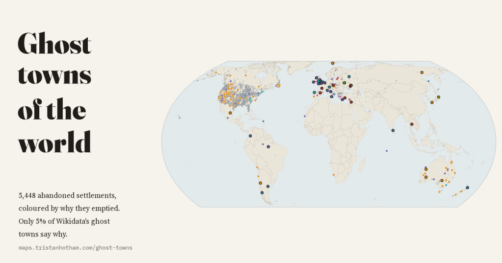
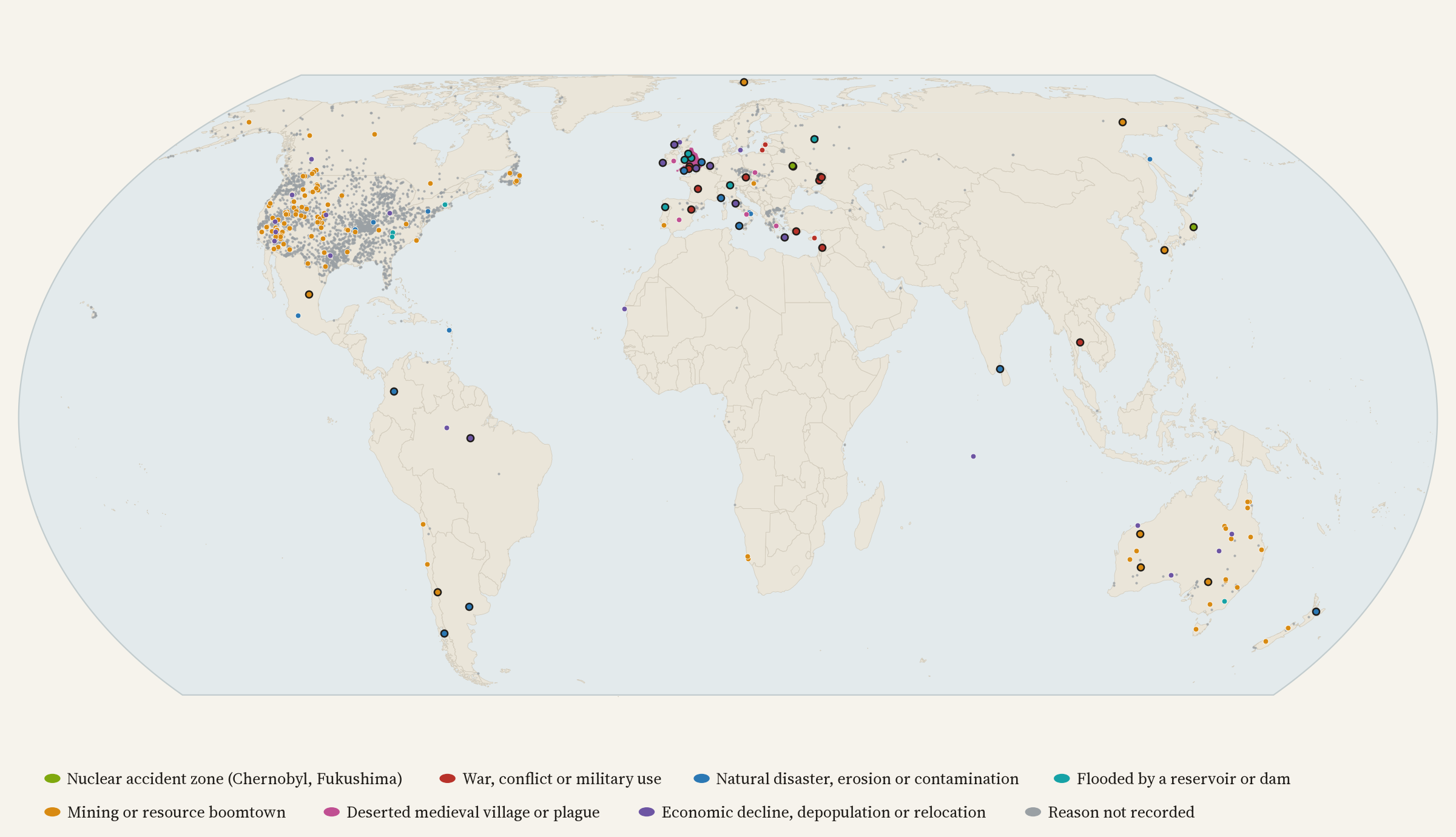
Mining camps that ran out of ore, valleys drowned by reservoirs, towns emptied by war, volcanoes and Chernobyl, and thousands of English villages that faded away centuries ago. I mapped every abandoned place I could find in open data and coloured each by why it emptied. The biggest surprise was how rarely the record says.
There is a lovely definition of a ghost town, from the Texas historian T. Lindsey Baker: “a town for which the reason for being no longer exists”. It invites the obvious question. What were those reasons, and where did they run out? A silver seam that played out, a railway that went somewhere else, a dam, an army, an earthquake, a reactor, or simply the young leaving one by one. I wanted a map of all of it, every abandoned place coloured by why.
Wikidata, the open database behind Wikipedia, has classes for exactly this: ghost town, abandoned village and deserted medieval village. With a position, there are 3,374 of them, once you strip out 2,456 Mexican municipalities that are very much alive but sneak in through a faulty link in Wikidata’s family tree of classes, and set aside 4,249 ancient cities. To these I added England’s 2,074 deserted medieval villages and hamlets from Maurice Beresford’s gazetteer, which I mapped earlier this year in The Villages That Vanished. For the reasons, I read Wikipedia’s ‘List of ghost towns by country’ (492 places) and its article on ghost towns.
A map of who wrote it down
The first thing the map shows is not where places were abandoned but where people have catalogued them. 80% of Wikidata’s ghost towns are in the United States, 2,700 of them, and 91% of those carry the same one-line description, “ghost town in such-and-such county”, the fingerprint of entries added in bulk. Canada has 265, Greece 101, Australia 58. All of Africa has 8.
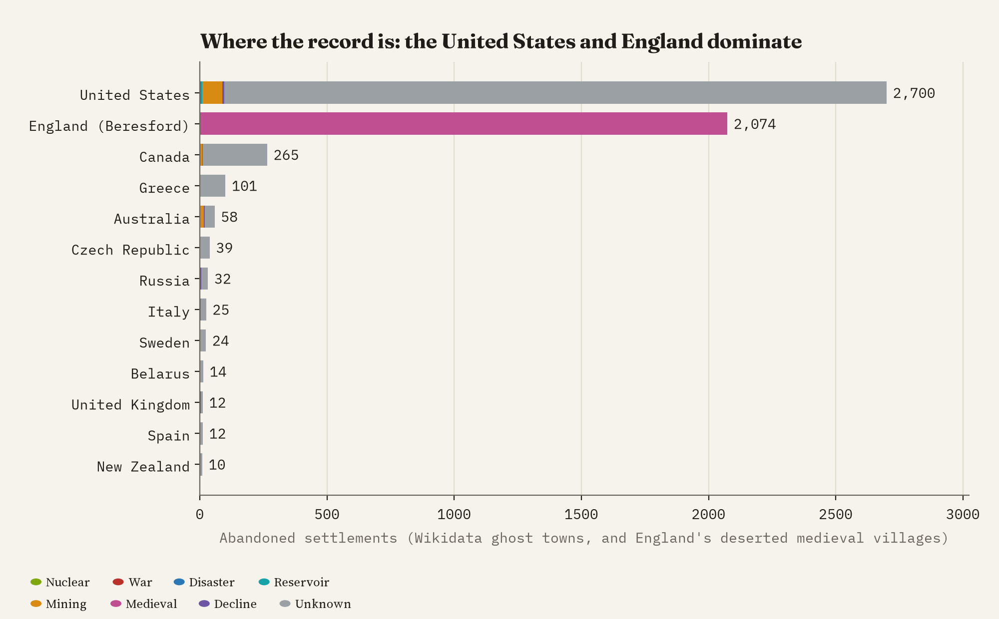
England is the other giant. Historians have been walking its fields looking for lost villages for seventy years, and their gazetteer makes England 38% of everything on the map. Together, the United States and England account for 88%. That is not a fact about history. It is a fact about bulk imports, enthusiasm and scholarship.
Why, where anyone says
I gave each place a reason using simple word rules, the same for every place and all published: “Chernobyl” means nuclear, “reservoir” or “dam” means flooded, “gold” or “colliery” means mining, and so on, with a confidence for each. Run on Wikidata, the rules find a reason for just 165 of 3,374 ghost towns, 5%, and 61 of those rest only on a name like Galena or Silver City. Wikipedia’s list is far chattier: 300 of its 492 places come with a reason.
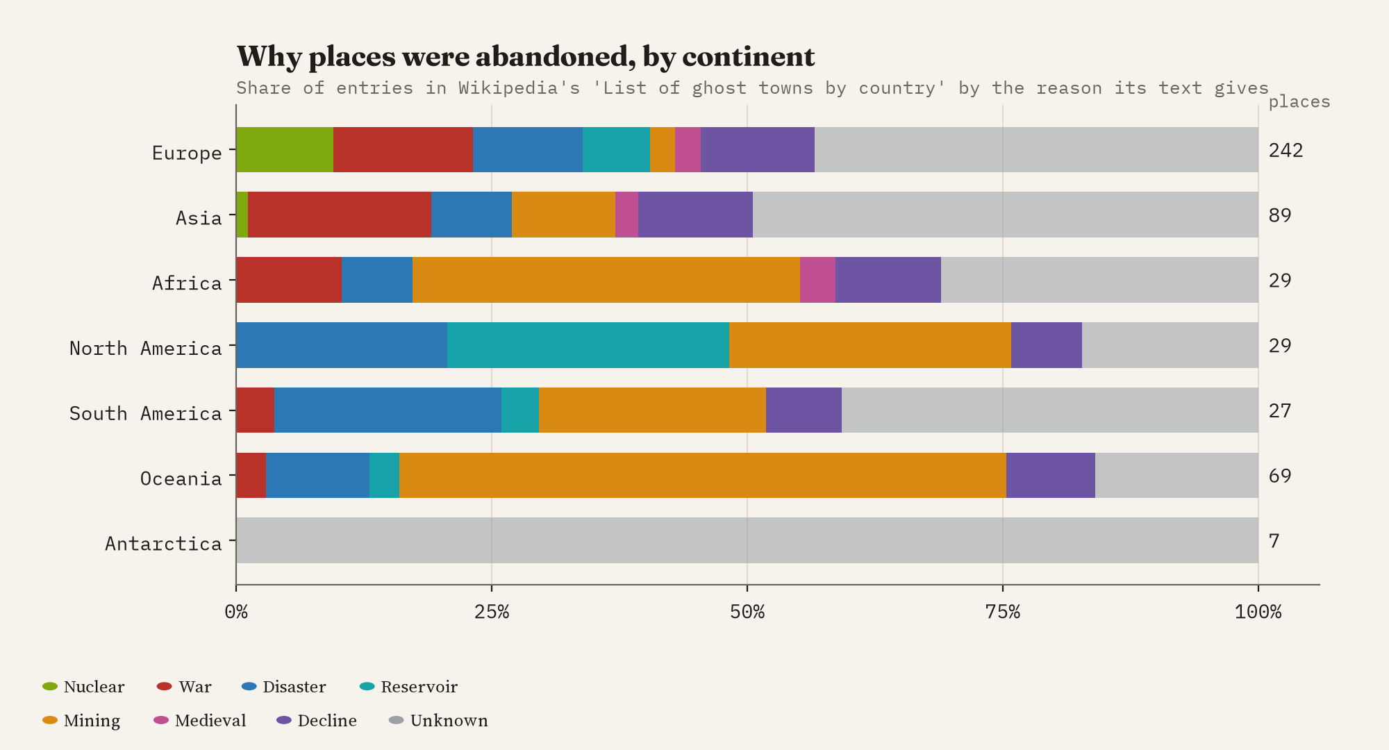
Mining and resource booms come first (81 places), then war (55) and disasters (54), economic decline (50), reservoirs (27) and nuclear accidents (24). Each continent has its own story. Australia is a land of dead gold and copper towns: 33 of its 51 entries. Europe’s list is led by war, from Oradour-sur-Glane, destroyed with its people by the Waffen-SS, to the English villages taken for army training in the Second World War, like Tyneham and Imber. Mexico’s is split between old mining towns, like the silver town of Real de Catorce, and villages drowned by reservoirs.
80% of Wikidata’s ghost towns are American, and only 5% of them say why they died.
The Wild West, by name only
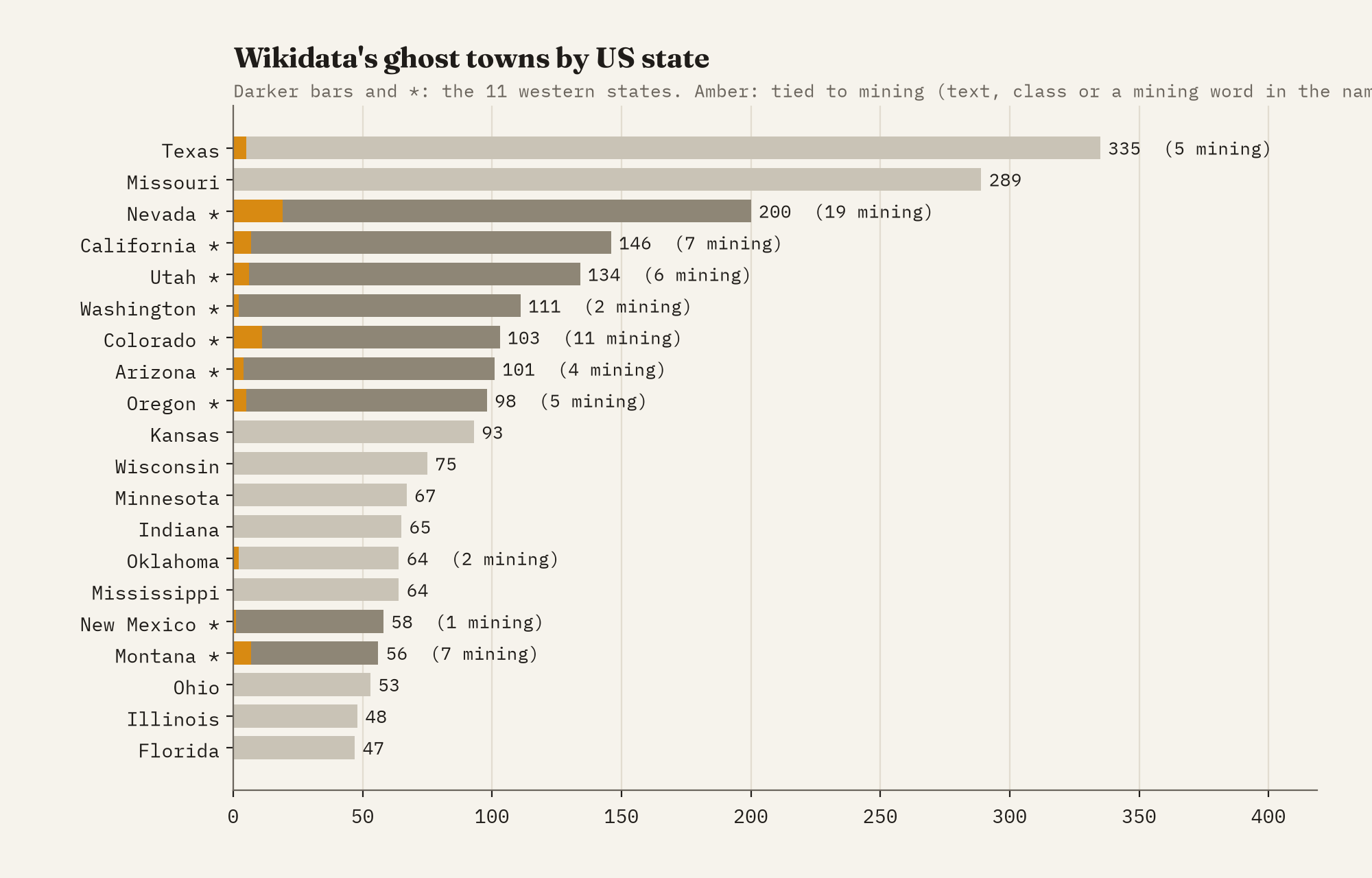
The ghost town of the imagination is a wooden street in Nevada, built for a mine. The data half agree. 1,053 of America’s ghost towns are in the 11 western states, and 65 of them are tied to mining, against 14 in all the rest of the country. But only 18 of those say so in words; 47 are just towns called Galena, Borax or Silver Reef. Bodie and Rhyolite, two of the most famous mining ghost towns there are, have no reason recorded at all. And the two states with the most ghost towns are Texas (335) and Missouri (289).
England’s thousands, and the Soviet north
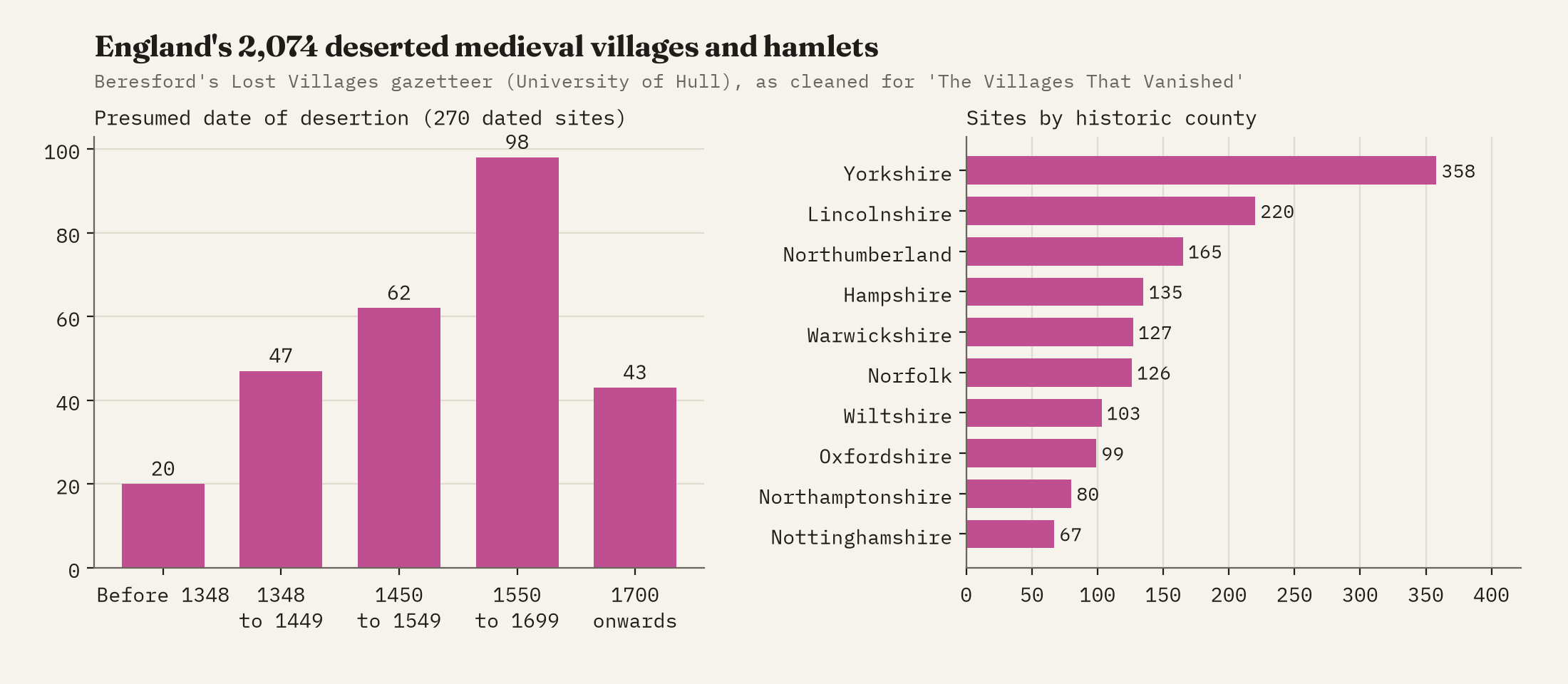
England’s lost villages are ghost towns of a quieter kind: bumps in a field and a hollow way where the street ran. The Black Death gets the blame, but of the 270 sites with a date, only 17% were deserted in the century after 1348, and 59% between 1450 and 1699, when landlords enclosed the fields and turned them to sheep. In the gazetteer’s accounts, enclosure and pasture come up 63 times and plague 32.
The former Soviet Union tells three stories. The biggest is Chernobyl: 23 of the places in Wikipedia’s list for Ukraine and Belarus were evacuated after 1986, Pripyat among them. Then there are the mining towns of the far north: Kadykchan in Magadan Oblast, Khalmer-Yu, where the mines were shut and the settlement wound up by 1995, and Pyramiden, the Soviet coal town on Svalbard. And there is the war: 7 Ukrainian towns in the list, such as Soledar and Popasna, emptied by fighting since 2022. Wikidata, meanwhile, has 62 ghost towns in all 15 republics, and 30 of them have no English name.
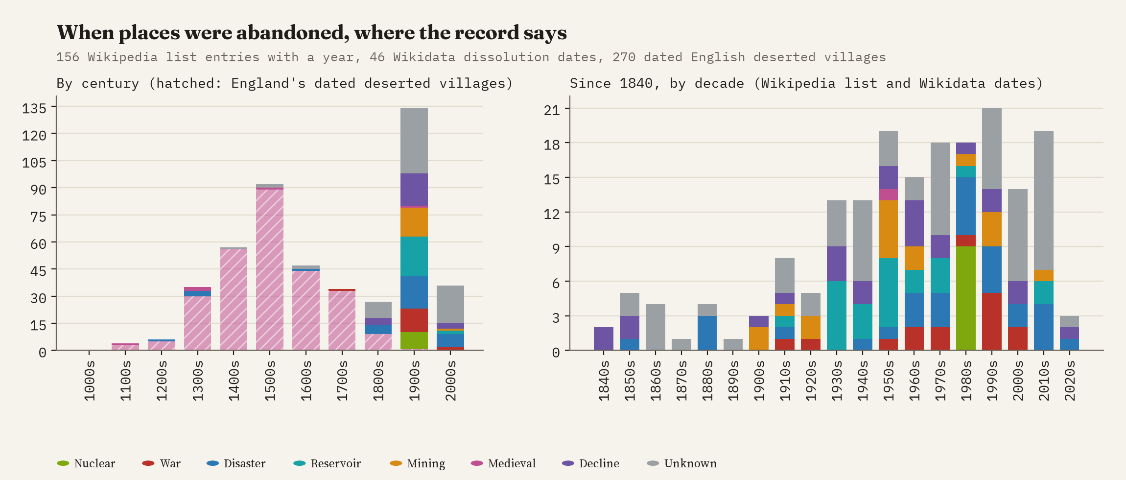
When the record gives a date, it is mostly recent: 85% of dated places in Wikipedia’s list were abandoned after 1900. The 1950s were the age of the reservoir and the mine closure, the 1980s of Chernobyl, and the 2010s have the most of any decade. Abandonment is not a thing of the past.
How I did this
I took every Wikidata item with a position classed as a ghost town, abandoned village or deserted medieval village, kept the real ghost towns and moved ancient cities to their own layer. England’s deserted villages come from Beresford’s gazetteer (University of Hull). Reasons come from keyword rules on Wikidata descriptions and on Wikipedia’s ‘List of ghost towns by country’ and ‘Ghost town’ article, in a fixed order when several match, each with a confidence: high if a text says it, medium if a Wikidata class implies it, low if only the name does. Because most of the list’s famous places, from Pripyat to Hashima, are not in the Wikidata extract and the list has no coordinates, I placed 44 of them by hand at approximate positions; they are on the map but in no count. Word rules make mistakes, the map shows the record rather than history, and most of Africa, Asia and South America is nearly blank. The paper has the full method and every caveat.
Notes and sources
- Wikidata (https://www.wikidata.org/), items classed as ghost town, abandoned village or deserted medieval village, queried through QLever in 2026. CC0.
- Beresford’s Lost Villages, University of Hull (https://dmv.wordpress.hull.ac.uk/), from M. Beresford and J. Hurst’s gazetteer. CC BY-NC-SA 4.0.
- English Wikipedia, ‘List of ghost towns by country’ and ‘Ghost town’, 2026. CC BY-SA 4.0.
- Natural Earth countries and states (public domain).
- I wrote the text, with drafting and editing assistance from Claude (Anthropic), which also helped prepare the analysis code. I reviewed and checked all text and results.

