
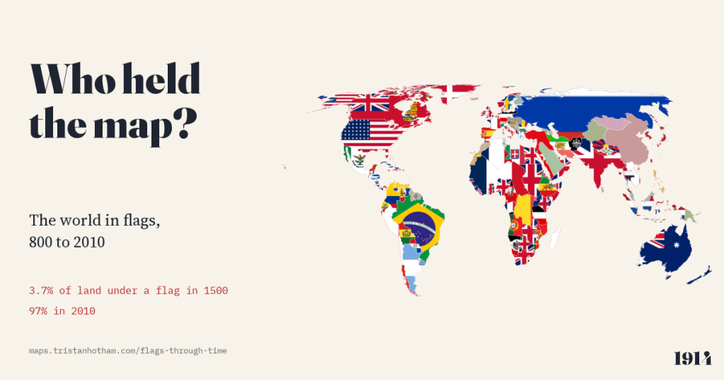
What would one of those world-maps-made-of-flags look like in 1500, or 1000? I built it: twelve centuries of the world map, area by area, each piece of land filled with the flag of whoever held it at the time. The most interesting part turned out to be the land where no flag can honestly be drawn.
You have probably seen the image: a world map where every country is filled with its own flag, the Stars and Stripes stretched across the United States, the Maple Leaf across Canada, the tricolour across Russia. I like it a lot, and it made me want to run it backwards. Whose flag would cover the land where Boston stands in 1700? What flew over Beijing in 1880, or Venice in 1500?
Two open datasets make it possible. Aleš Ourednik’s historical-basemaps project draws the world at many dates, naming each area and the power that controlled it. Wikidata records the flags of many states, often with the years each was in use, and Wikimedia Commons holds the pictures. I joined them for 30 dates from 800 to 2010, and put the result on a map with a play button.
A map with almost no flags
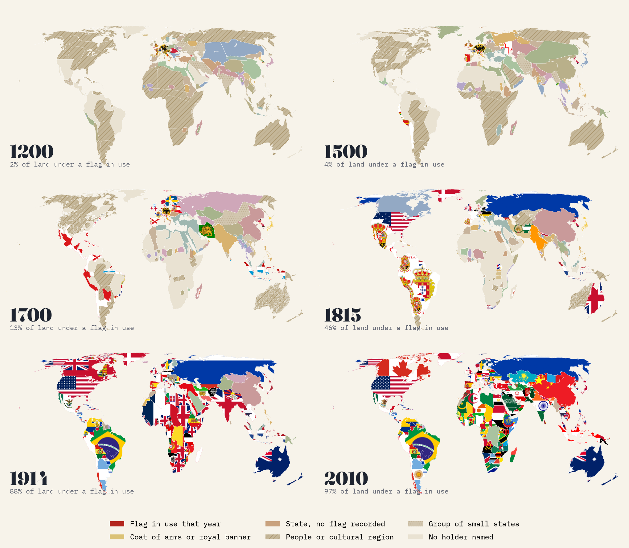
Press play from the year 800 and the first surprise is how long the map stays empty of flags. In the year 1000 not one piece of land can honestly be filled with a flag in use at the time. Heraldry had not yet emerged, and 48% of the world’s land belonged to peoples and cultural regions rather than states. Even in 1500 the share of land under a flag in use is just 3.7%.
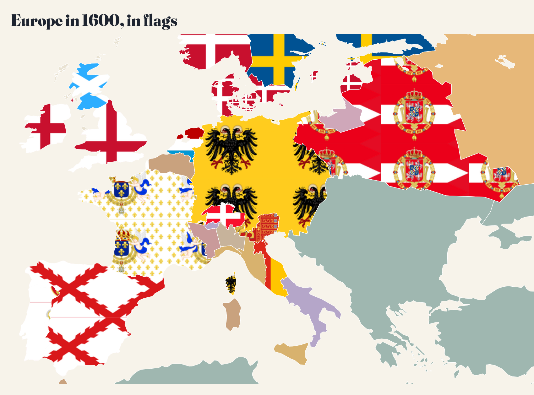
That is a choice, and an important one. Wikidata does hold flags for the Ottomans of 1400, but marks them as fictitious, and for Muscovy in 1530 it offers today’s Russian tricolour. Many medieval flags online are modern reconstructions. So I set rules. A flag is shown only if its recorded dates cover the year, or if it is an undated flag of a state that no longer exists, within that state’s lifetime and after 1150. Otherwise the area gets a coat of arms or royal banner where one fits, or a plain colour with its name. Flags Wikidata marks as fictitious or conjectural are never used. The Ottomans, for example, stay plain until their red flag with crescent and star is recorded from 1844.
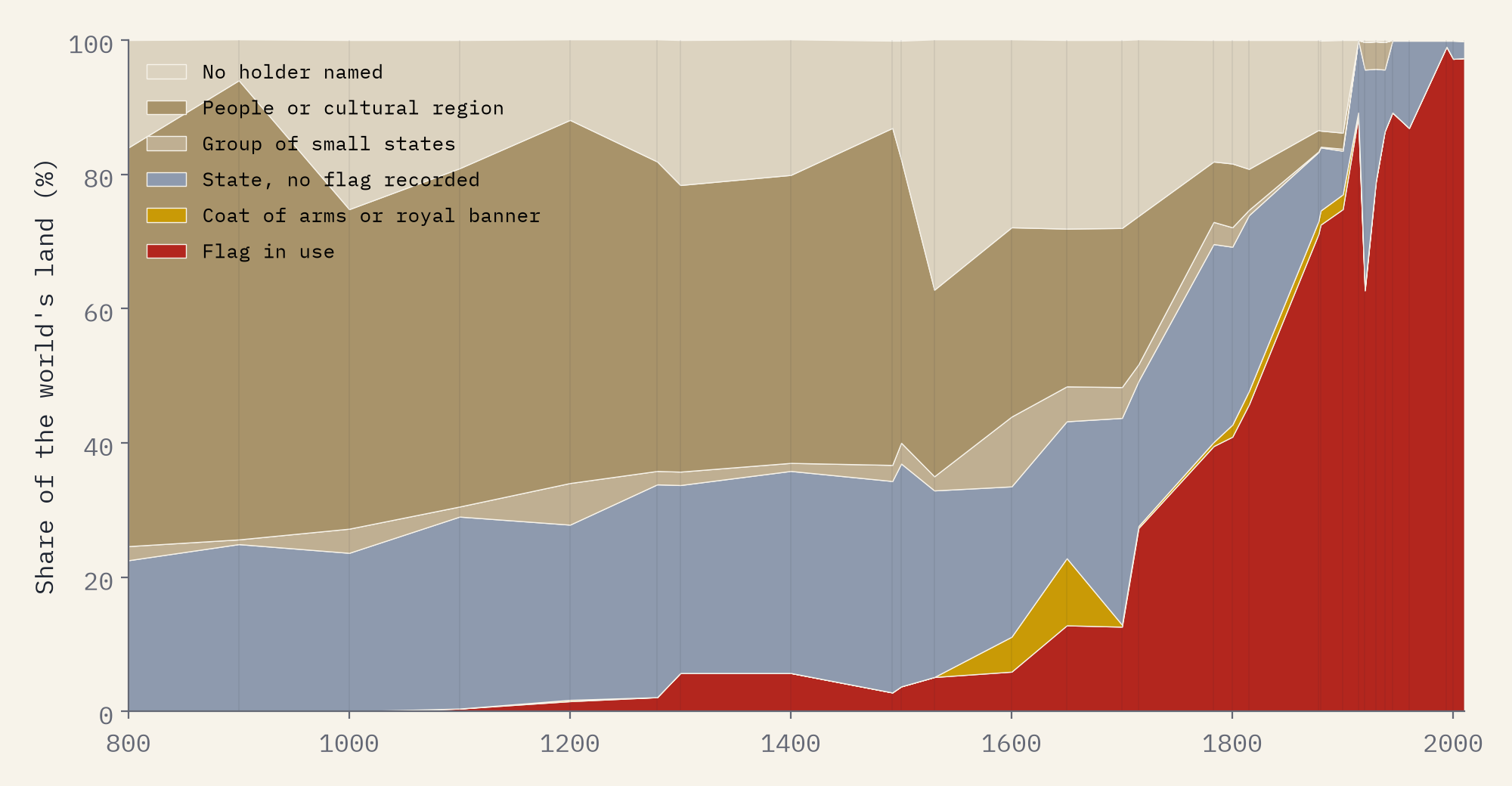
The map fills in the 18th and 19th centuries, as national flags spread from ships to states and the European empires carried theirs across the world. The share passes half in the 1878 snapshot and reaches 97% in 2010.
The biggest flags on the map
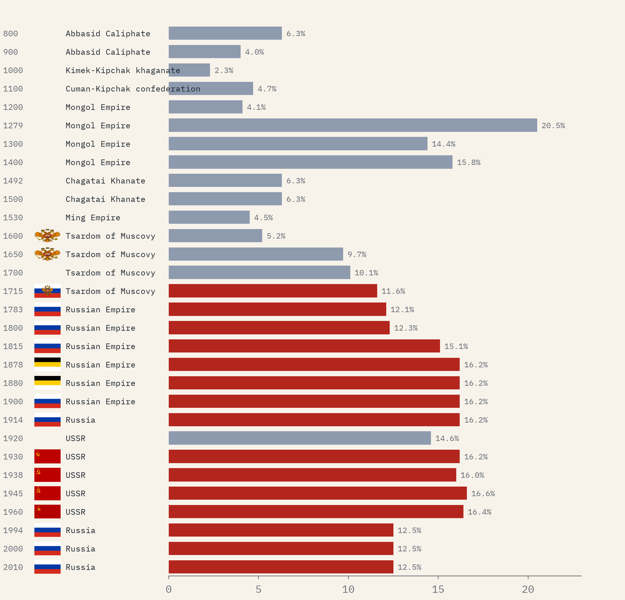
The largest single entry in the basemap at any date is the Mongol Empire in 1279, with 20.5% of the world’s land in one connected land empire, and it has no flag on the map: none is recorded for it. It was not the largest empire overall, though: counting only the United Kingdom and its self-governing dominions, the British Empire in 1914 held 24.1%. From 1600 the largest single entry in every snapshot is Russia, as Muscovy, the Russian Empire and the Soviet Union. The British Empire is trickier: the basemap gives the dominions their own names, so the United Kingdom’s own land peaks at 11.0% in 1914, or 24.1% with Canada, Australia, New Zealand and South Africa added.
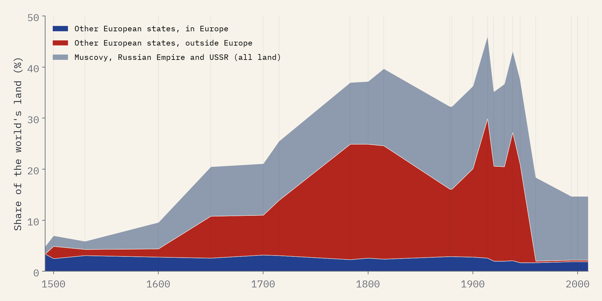
European states held 4.9% of the world’s land in 1492 and 46.1% in 1914, counting Russia; without Russia the peak is 29.9%. Some of the ups and downs are the basemap’s labelling rather than history, which I explain in the paper.
One place, many flags
My favourite view is the simplest: pick a city and read its flags across time. The land where Boston stands is shown until 1400 as the country of eastern North American hunter-gatherers, then as the land of the Massachusett and the Iroquois, then under England, Great Britain and, from 1783, the United States. Beijing passes from the Tang to the Liao, the Mongols, the Ming, the Qing, the warlords, the Republic of China and the People’s Republic. Moscow has the most holders of the sixteen cities I followed: 9.
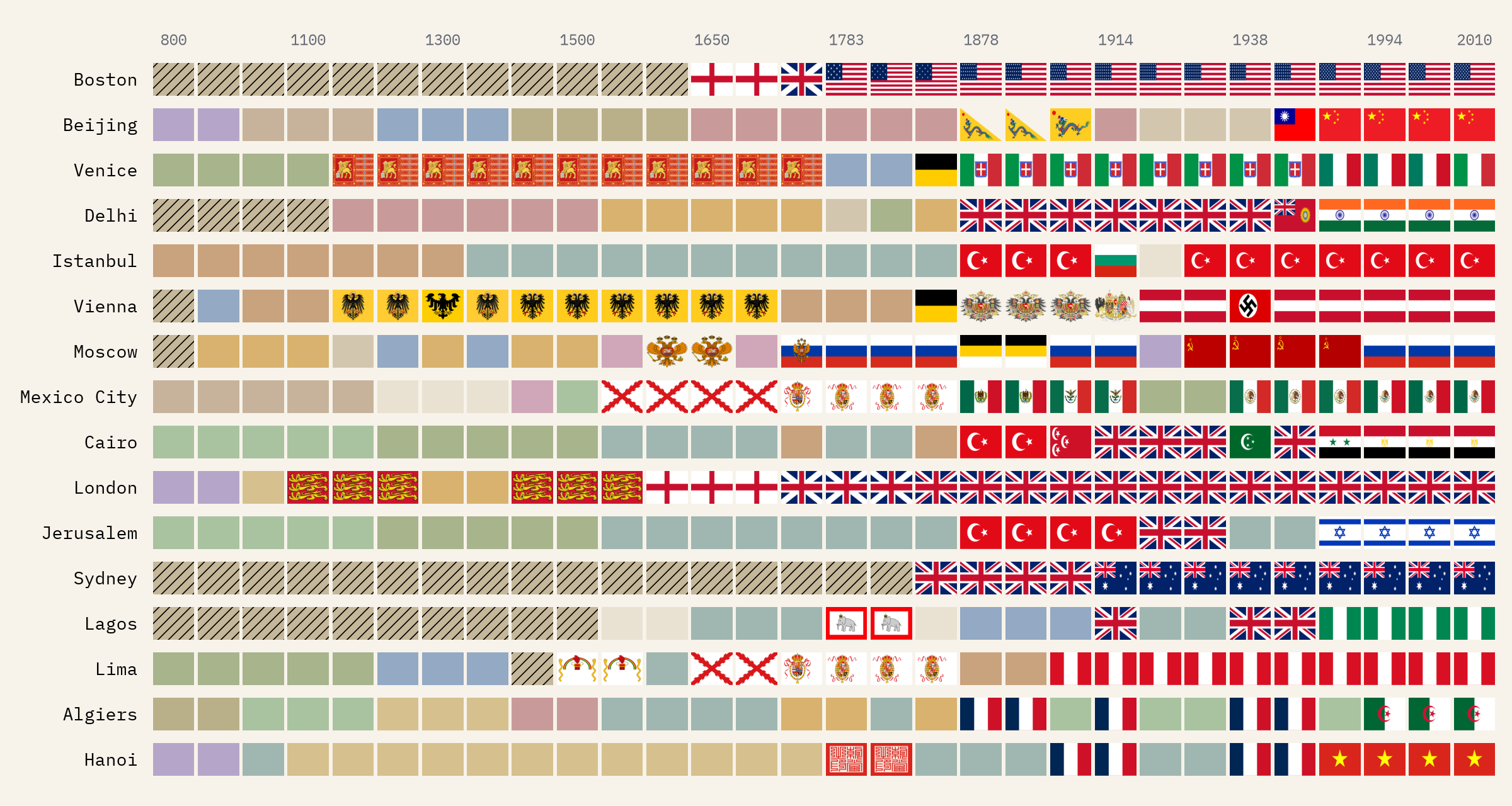
In the year 1000, not one piece of land can honestly be filled with a flag. By 2010, 97% can.
How old are today’s flags, honestly?
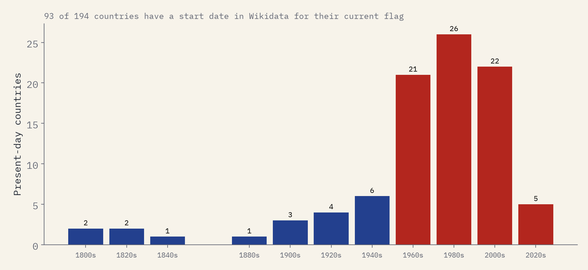
Charts of when every country adopted its flag do the rounds too, usually without sources. Wikidata gives a start date for the current flag of 93 of 194 present-day countries, so that is what I plotted, and I left the rest out rather than guess. The median is 1986, much younger than flags feel, partly because Wikidata often dates the current version: Japan’s flag from the 1999 law, Italy’s from a change of shade in 2006, France’s from a darker blue in 2020. Denmark’s Dannebrog, often called the oldest of all, has no date and is missing.
What the map cannot say
Many areas on the older maps are peoples or ways of life rather than states: Australian aboriginal hunter-gatherers, Bantu peoples, the Sámi, the nations of the Americas. They are shown hatched with their own names. Many of these societies governed themselves without states, and none used a national flag of the European kind; the flags some use today are modern and would be wrong on a map of 1500. The basemaps are simplified and in places disputed, borders before 1500 were often zones rather than lines, and the flags are those Wikidata knows, so well-documented states are rich in them. Treat a flag on a medieval map as a state’s recorded emblem, not proof that it flew there that year.
How I did this
I took the 30 historical-basemaps snapshots from 800 to 2010, measured each area’s land on an equal-area grid, and joined spelling variants of each holder. I corrected 2 clear labelling errors in the 1930 map. Each holder was matched to Wikidata items by name, choosing for each year an item whose founding and end dates cover it, and I set the items by hand for 76 important holders such as France’s kingdom and republics, the Qing, and both Chinas: 78.7% of states matched, covering 94.2% of the land they held. Flags then follow the rules above. Borders are not interpolated between snapshots. Every one of the 413 images is credited with its licence, and the data and code are free to reuse.
Notes and sources
- Ourednik A and contributors, historical-basemaps, GPL-3.0. The simplified boundaries I publish derive from it and are GPL-3.0 too.
- Wikidata (flags, coats of arms and dates), CC0, via QLever.
- Flag and coat of arms images from Wikimedia Commons, each credited with its licence in the credits file; two present-day flags from flag-icons (MIT).
- Natural Earth present-day countries (public domain).
- I wrote the text, with drafting and editing assistance from Claude (Anthropic), which also helped prepare the analysis code. I reviewed and checked all text and results.

