
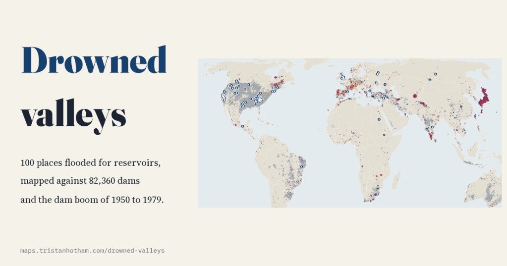
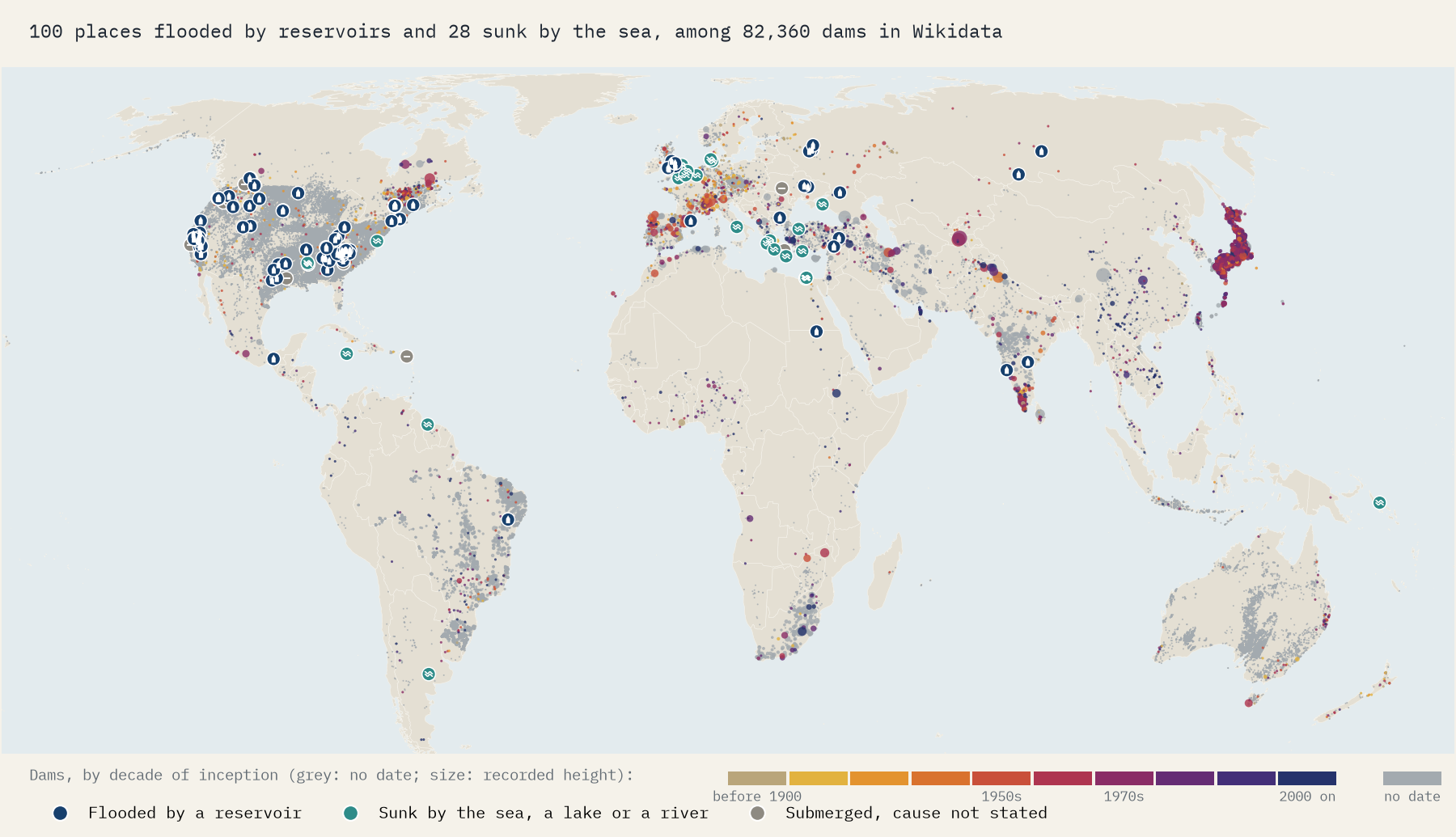
In 1965 a Welsh valley was flooded to give Liverpool water, and a village went under with it. Capel Celyn was one of hundreds. I mapped the 100 drowned places that Wikipedia records as flooded by a reservoir, and set them against the great dam boom of the twentieth century.
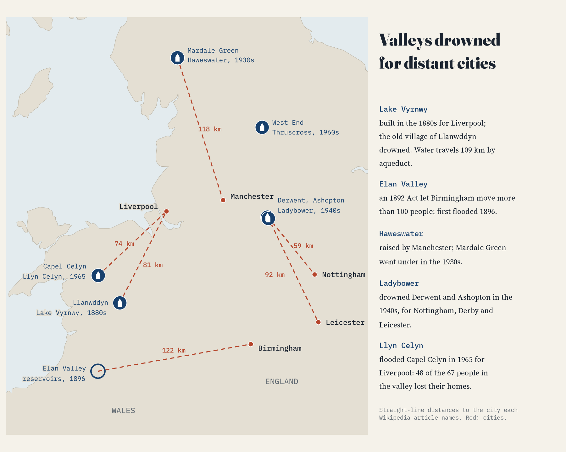
Capel Celyn sat in the Tryweryn valley, north west of Bala, and was one of the last Welsh-only speaking communities in the area. In 1965 Liverpool flooded the valley to make Llyn Celyn, and 48 of the 67 people who lived there lost their homes. The scheme was opposed by 125 local authorities and won no support from Wales’ 36 members of Parliament, but it went through. Liverpool City Council apologised in 2005. Graffiti near Llanrhystud reading Cofiwch Dryweryn, “remember Tryweryn”, became an icon of Welsh feeling.
I wanted to see how many places shared Capel Celyn’s fate, and when. English Wikipedia has categories for submerged places, communities depopulated for reservoir creation, places inundated by the Tennessee Valley Authority and the Lost Villages of the St Lawrence. Together with underwater ruins and flooded valleys they hold 186 pages. Setting aside 40 that are not drowned places at all, I read the opening of each of the other 146 and recorded the sentence that says how it went under. 100 were flooded by a reservoir, 28 were taken by the sea, a lake or a river, and for 18 the text does not say.
Three decades of dams
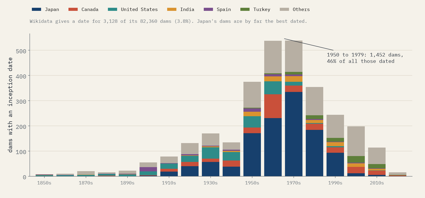
Wikidata lists 82,360 dams, but gives a building date for only 3,128 of them, and those are heavily Japanese. So this is not a census. But the shape is unmistakable: fewer than 25 dated dams a decade before 1900, 170 in the 1930s, then 375, 538 and 539 in the three decades from 1950. 46% of all the dated dams were built between 1950 and 1979.
The drowned places follow the dams. Where the article dates the flood, 60 of 68 places went under between 1930 and 1979, and the busiest decade was the 1950s. The earliest is Llanwddyn, drowned by Lake Vyrnwy in the 1880s; the latest Zeugma on the Euphrates, whose mosaics were rescued before the Birecik Dam flooded it in 2000.
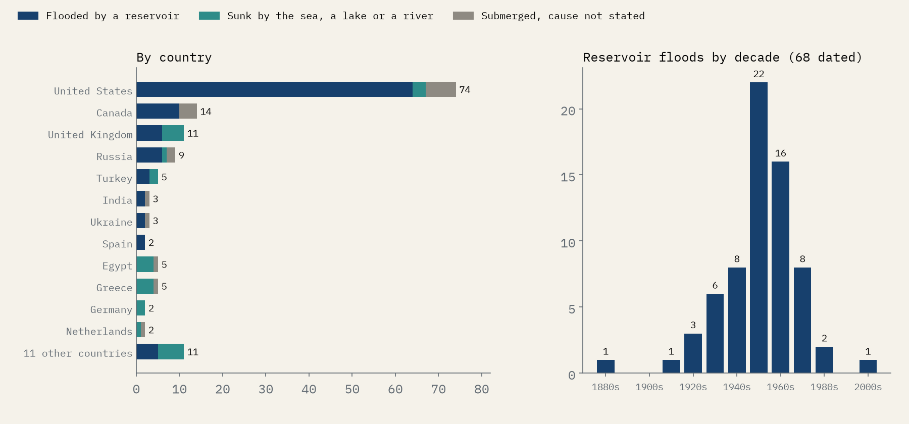
64% of the reservoir places are American. That partly reflects Wikipedia, which has an article for many small western towns, but the losses were real: the St Lawrence Seaway took ten Canadian communities on the shore near Cornwall, Ontario in 1958, and the Tennessee Valley Authority’s lakes covered towns from Loyston in 1936, documented before the flood by the photographer Lewis Hine, to the Overhill Cherokee town sites of Chota, Tanasi and Tuskegee in 1979. Tanasi gave the state of Tennessee its name.
Welsh water, English cities
Britain’s drowned villages tell a sharper story, because most were flooded for cities somewhere else. Lake Vyrnwy was built for Liverpool in the 1880s and drowned the old village of Llanwddyn. An Act of 1892 let Birmingham move more than 100 people out of the Elan Valley. Manchester raised Haweswater and drowned Mardale Green in the 1930s. Ladybower took Derwent and Ashopton in the 1940s, for Nottingham, Derby and Leicester; Derwent’s church tower stood in the water until it was blown up in 1947. In a straight line, Capel Celyn is 74 km from Liverpool, and the Elan Valley 122 km from Birmingham.
60 of the 68 dated drowned places went under between 1930 and 1979.
The giants
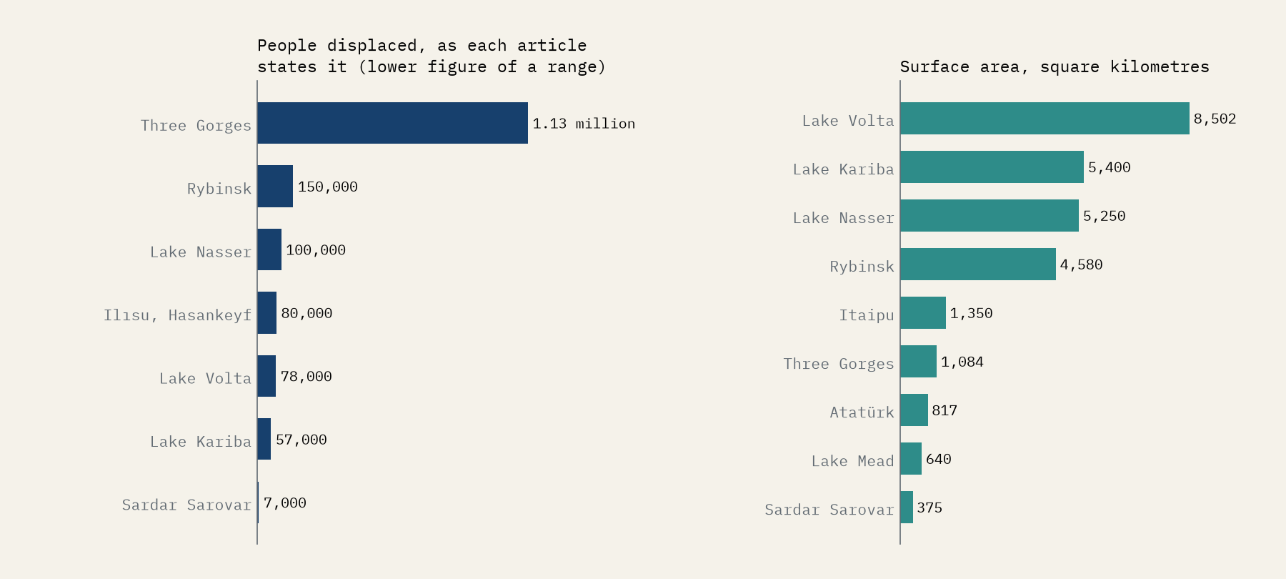
A map of places with their own article hides the biggest losses, because the largest schemes drowned hundreds of villages that have none. Their own articles give the scale. The Rybinsk Reservoir on the Volga, filled from 1941, meant resettling some 150,000 people; the town of Mologa and 663 villages disappeared under the water. Lake Nasser, behind the Aswan High Dam, displaced 100,000 to 120,000 Nubians, and the temples of Abu Simbel were moved to save them. Lake Volta in Ghana, the largest artificial reservoir in the world by surface area, flooded 740 villages and 78,000 people had to move. Lake Kariba displaced about 57,000 Tonga people. For the Three Gorges Dam, estimates run from 1.13 million to around 1.4 million.
Some drowned places still come back. Curon’s church tower stands in Lake Resia in the Alps, the old church of Sant Romà de Sau shows above its Catalan reservoir, and in dry years the old church of Quechula in Mexico and parts of Curdi in Goa rise out of the water again.
Dying before the water came
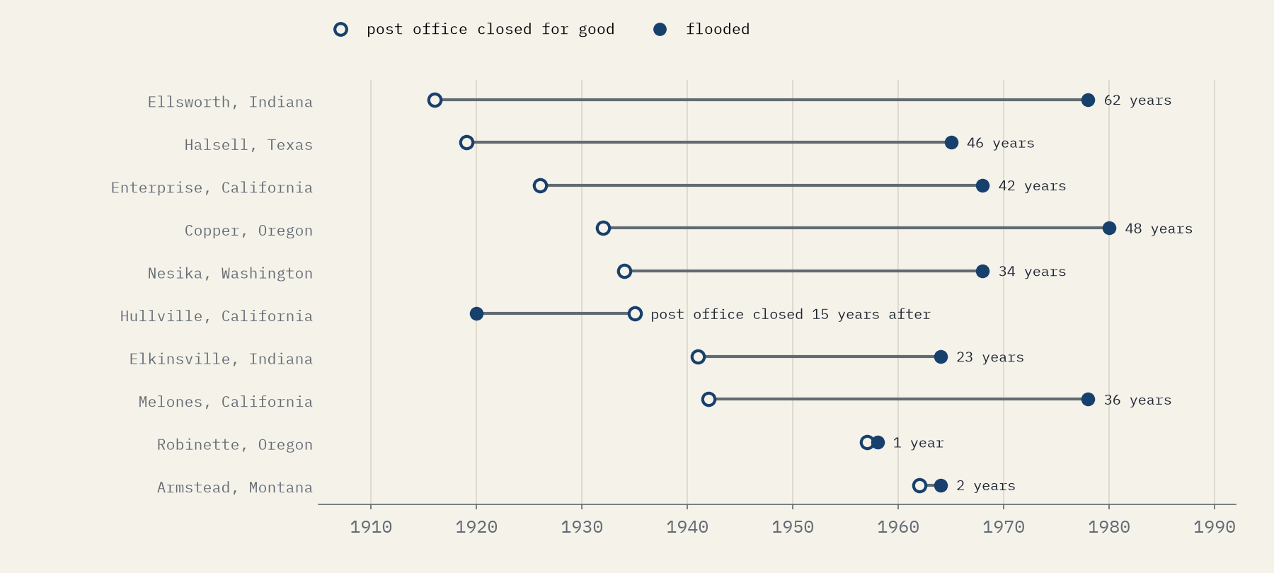
Many of the small American towns were fading long before the dam. For ten of them the article gives the year the post office closed for good as well as the year of the flood. The median gap is 35 years. Ellsworth, Indiana lost its post office in 1916 and went under the Patoka Reservoir in 1978; Armstead, Montana kept its post office until 1962 and was flooded two years later.
How I did this
I took every page in the six Wikipedia categories, set aside people, languages, temples, lists and the like, and for each remaining page recorded the sentence in its opening text that says how it went under; the build checks each quotation against the article word for word. A place counts as flooded by a reservoir if that sentence names a reservoir, dam or man-made lake, or, for four pages that say nothing more, if it sits in a reservoir category. The year is the one the article gives for the flood, the filling or the dam’s completion. Dams and reservoirs come from Wikidata; its heights, areas and volumes carry no units in this extract, so reservoir areas come from the Wikipedia articles instead. The paper sets out every rule and caveat.
Notes and sources
- English Wikipedia contributors, the pages in the categories Submerged places, Communities depopulated for reservoir creation, Populated places inundated by the Tennessee Valley Authority, The Lost Villages, Underwater ruins and Flooded valleys, and articles on the reservoirs named, CC BY-SA 4.0.
- Wikidata dams and reservoirs, CC0.
- Natural Earth country outlines and populated places (public domain).
- I wrote the text, with drafting and editing assistance from Claude (Anthropic), which also helped prepare the analysis code. I reviewed and checked all text and results.

