
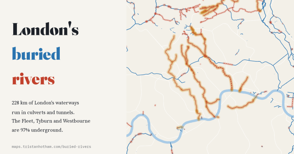
Under London’s streets run dozens of rivers that were bricked over, piped and turned into sewers. I measured how much of the capital’s mapped waterway still flows in the open, how much runs in the dark, and what the open map can and cannot tell us about the Fleet, the Tyburn, the Westbourne and the rest.
Stand on the platform at Sloane Square and a river passes over your head. The Westbourne, which rises in Hampstead, gave Bayswater its name and was dammed to make the Serpentine, crosses the station in an iron pipe. A few streets east, the Tyburn runs beneath Buckingham Palace, and beyond it the Fleet, which gave its name to Fleet Street, flows under Farringdon Road in a sewer. London was built on top of its streams, and most of them are still there, out of sight.
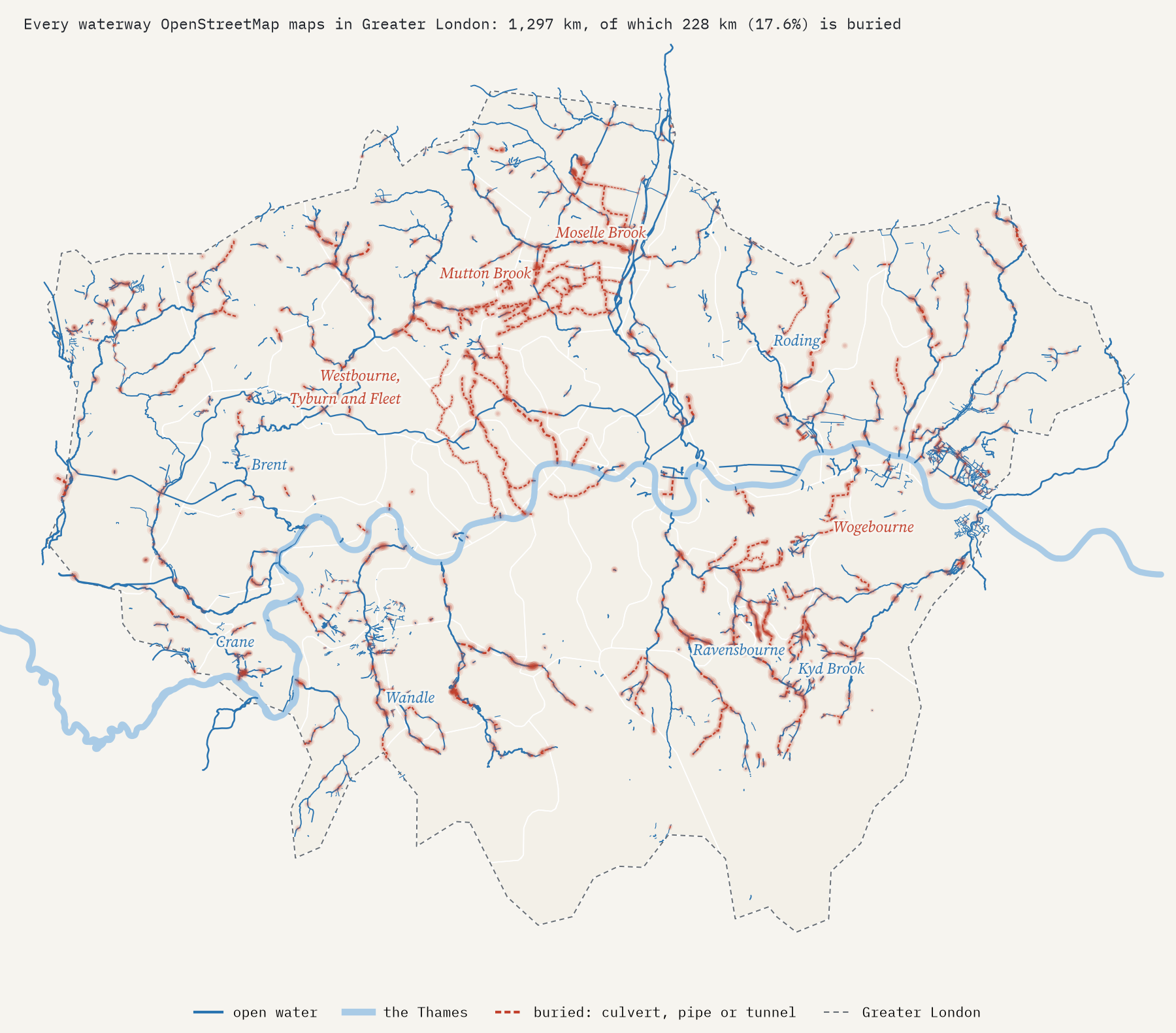
OpenStreetMap, the open map that volunteers keep up to date, records many of these hidden waterways, tagged as running in culverts or tunnels. I took every river, stream, canal, drain and ditch it maps inside Greater London, 1,297 km of them, and measured which parts are underground. The answer: 228 km, or 17.6%. About one kilometre in 6 runs in the dark.
Small streams went first
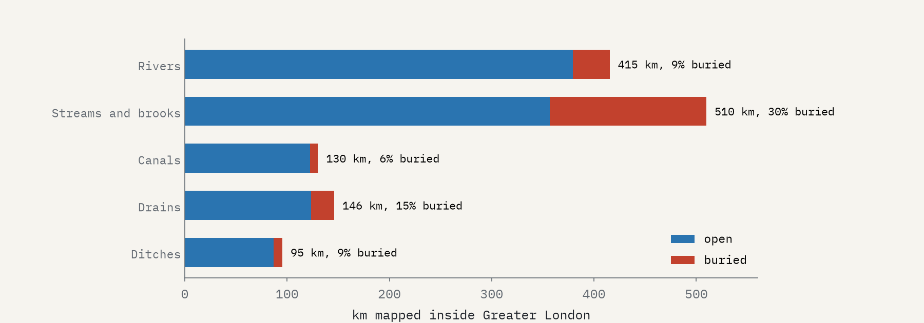
The big rivers mostly survived, because they were too large to cover: only 8.6% of the length tagged as river is underground, and almost none of the Thames. It was the small streams that disappeared. Of 510 km of streams and brooks, 30% are buried, and they make up 67% of all the buried waterway in London.
The Tyburn never sees daylight
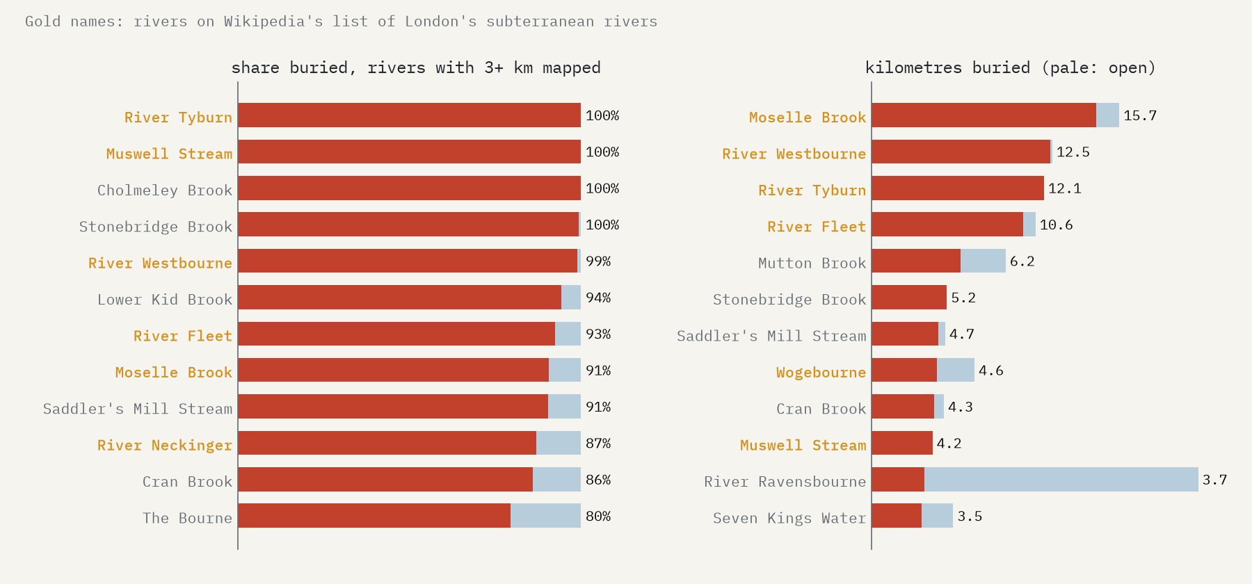
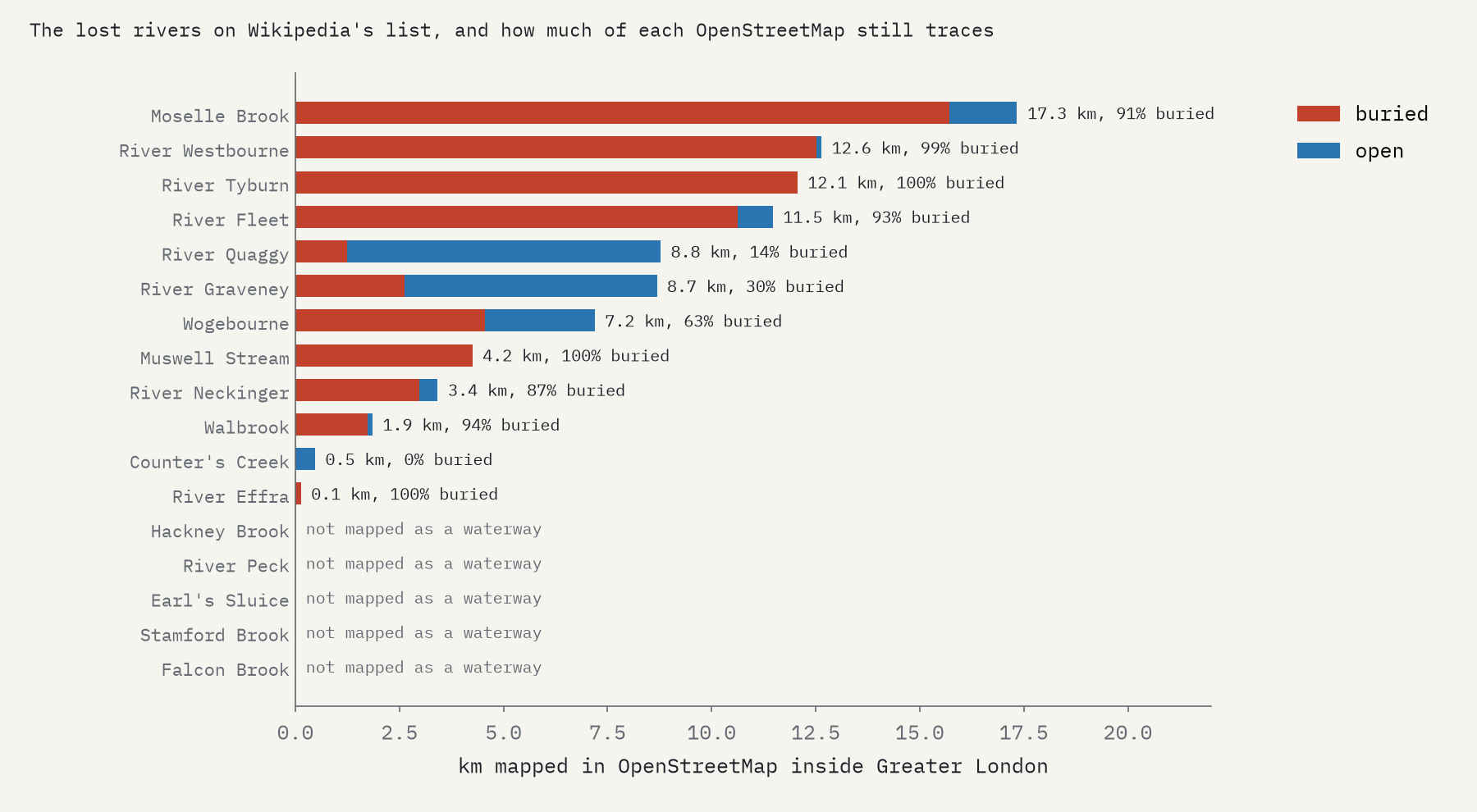
Among the 79 named waterways with at least 3 km mapped, 21 are more than half buried. The Tyburn is buried for every metre of its 12.1 km. The Westbourne is 99% underground and the Fleet 93%, its only open water being the ponds on Hampstead Heath where it rises. By sheer length of tunnel, though, the leader is the Moselle Brook in Tottenham, with 15.7 km of culvert. Many of the others are suburban brooks piped in the twentieth century as estates were built over them.
From open sewers to Bazalgette
The lost rivers’ Wikipedia articles tell how it happened. After the Great Fire the Fleet was turned into the New Canal, finished in 1680 under Robert Hooke; it was covered over in stages from 1737 until the 1870s. The Westbourne fed the Serpentine from 1730 until 1834, when it had become too foul. The Effra was classed as an open sewer below North Brixton by 1821 and arched over in 1847. In 1838 Charles Dickens called Jacob’s Island, on the tidal ditches of the Neckinger, the filthiest of the many places hidden in London. Then Joseph Bazalgette’s sewers gathered them up: his northern high level sewer swallowed the Hackney Brook in 1860.
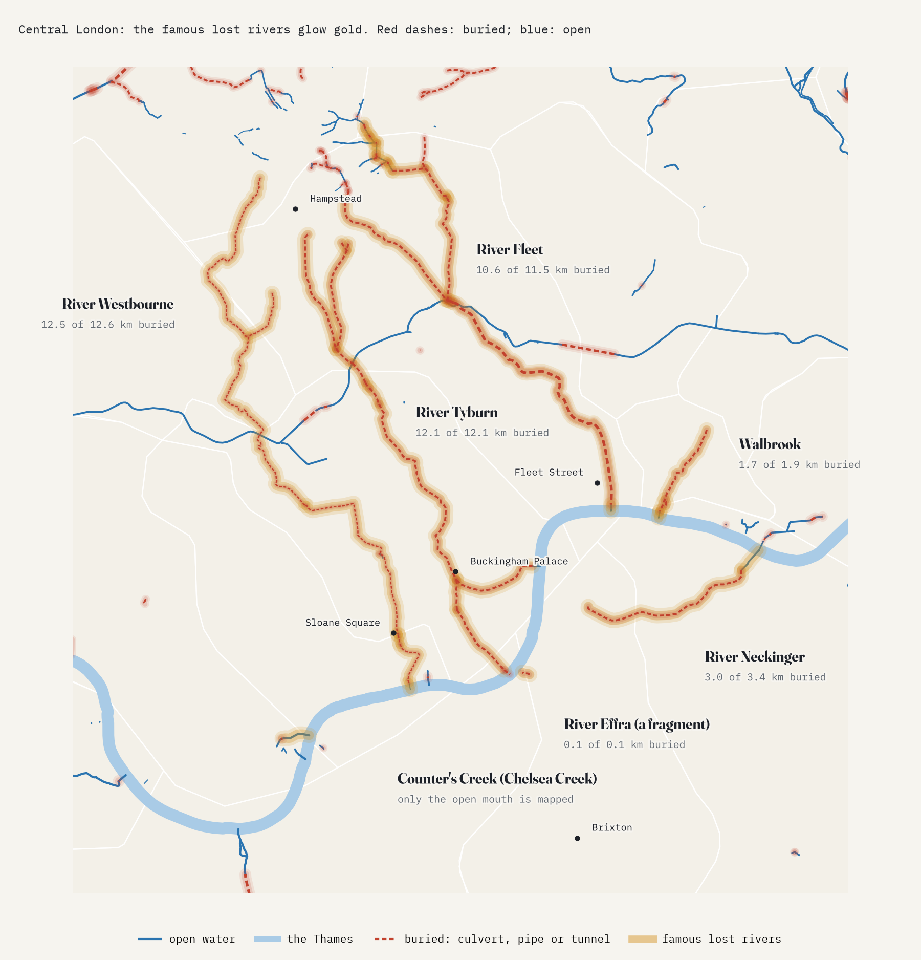
The Fleet, the Tyburn and the Westbourne are 97% underground: 35.2 of 36.2 mapped kilometres.
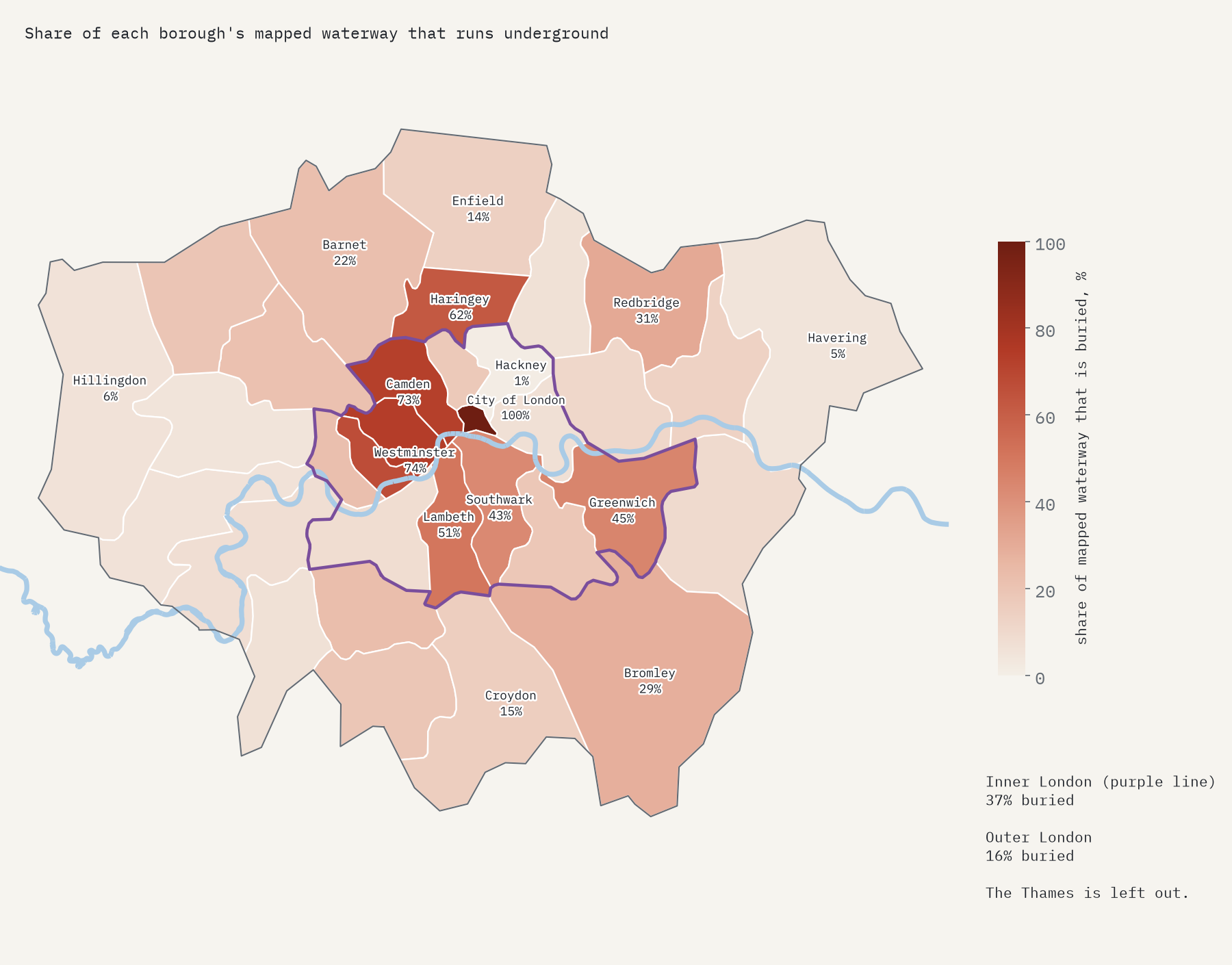
Inner London buried its rivers twice as often
Leaving out the Thames, 37% of the waterway mapped in inner London is buried, against 16% in outer London. Every mapped metre in the City of London is underground, and Westminster (74%) and Camden (73%) come next. Haringey has the most buried waterway of any borough, 34.1 km, thanks to the Moselle and its neighbours. And Hackney comes bottom, with 1.2%, not because it kept its rivers but because the Hackney Brook, which once ran right across it, is not on the map at all.
What the map cannot show
An open map records what volunteers can see or trace, and a river that has become a sewer is hard to trace. Of 17 lost rivers I looked for, 5 are not mapped as waterways at all: the Hackney Brook, the Peck, Earl’s Sluice, Stamford Brook and Falcon Brook. The Effra, which once drained some 20 square kilometres of south London, appears as 0.13 km of culvert, and Counter’s Creek only as its open tidal mouth, Chelsea Creek. So the totals here are a floor. There is a good deal more buried river under London than any map shows.
Some of the buried rivers are coming back. In the 1960s the Quaggy was forced into straight concrete channels; at Chinbrook Meadows the concrete was torn out and the river given back its bends, a project finished in 2002. In 2009 the London Rivers Action Plan set out to bring more rivers back to the surface. The Fleet and the Tyburn are unlikely to see the sky again, but you can still read their valleys in the slope of the streets, and hear the Fleet through a grating in Ray Street, Clerkenwell.
How I did this
I downloaded every OpenStreetMap way tagged as a river, stream, canal, drain or ditch in and around London and counted a way as buried if it is tagged as a culvert or tunnel, as covered or underground, or is drawn below ground level. I clipped each way to the Greater London boundary and the borough outlines from Natural Earth and measured its length, and grouped ways by name into rivers. A few extra channel lines drawn beside the Thames were left out so that the river is not counted twice. The histories come from English Wikipedia’s articles on each river; I give no date that they do not. The paper sets out every step and caveat.
Notes and sources
- Waterways: © OpenStreetMap contributors, Open Database Licence. The derived waterway data are also ODbL.
- Histories: English Wikipedia, Subterranean rivers of London and the articles on each river, CC BY-SA 4.0.
- Natural Earth outlines of Greater London and the boroughs (public domain).
- I wrote the text, with drafting and editing assistance from Claude (Anthropic), which also helped prepare the analysis code. I reviewed and checked all text and results.

