
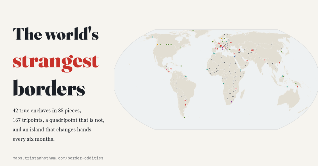
There is a front door in the Netherlands with a Belgian house number. There was, until 2015, a field in India inside Bangladesh inside India inside Bangladesh. I went looking for every strange border in the world, and then checked what a map can actually see.
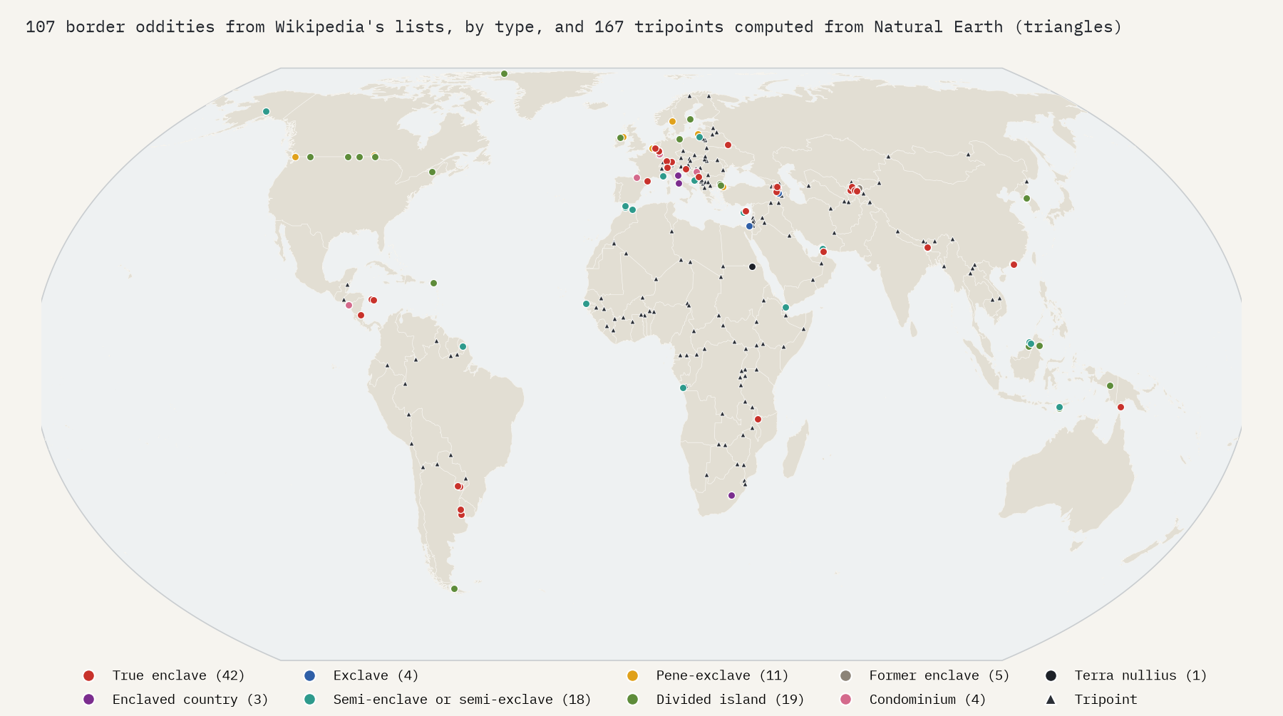
An enclave is a piece of one country with another country on every side. Wikipedia keeps a long list of them, along with exclaves, semi-enclaves, pieces of countries you can only drive to through a neighbour, and islands split down the middle. I turned the national-level part of that list into a map: 107 places, with every tripoint I could compute from Natural Earth, the free map of the world’s countries that most data maps are drawn on.
Forty-two true enclaves
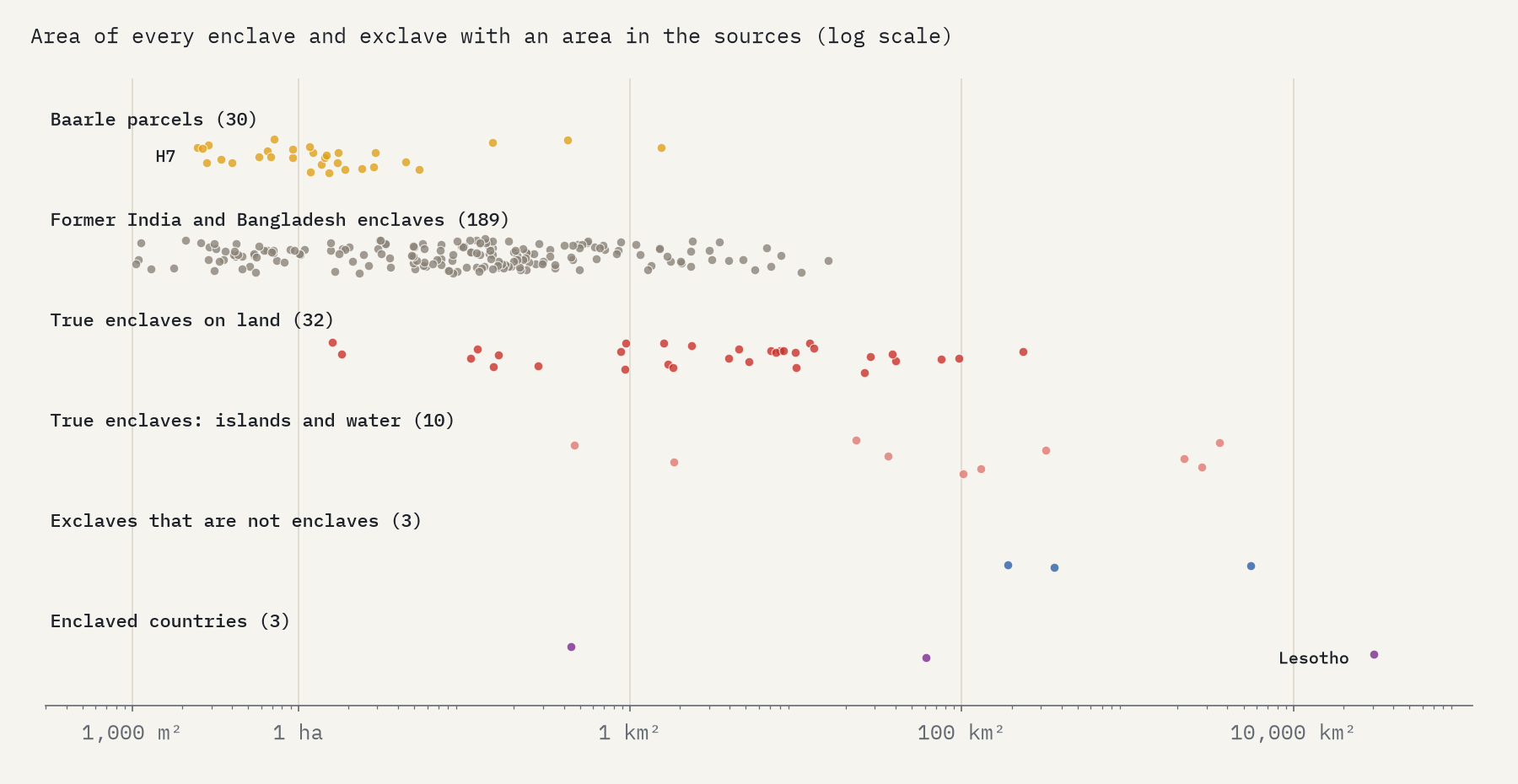
Strictly, a true enclave is both: entirely surrounded by one other country, and part of a country somewhere else. Wikipedia lists 42 of them, in 85 separate pieces, belonging to 24 countries. Germany owns the most, 6: Büsingen on the Rhine, inside Switzerland, and 5 scraps of land cut off when the Treaty of Versailles handed Belgium a railway line that ran through Germany. Belgium owns the most pieces, 22, all in one Dutch town.
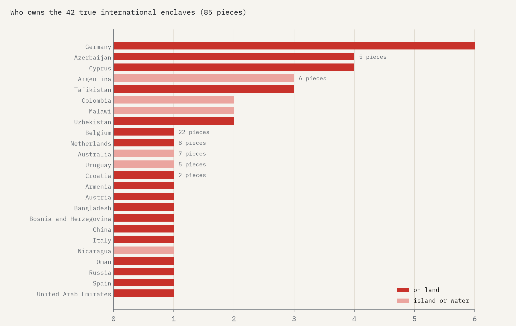
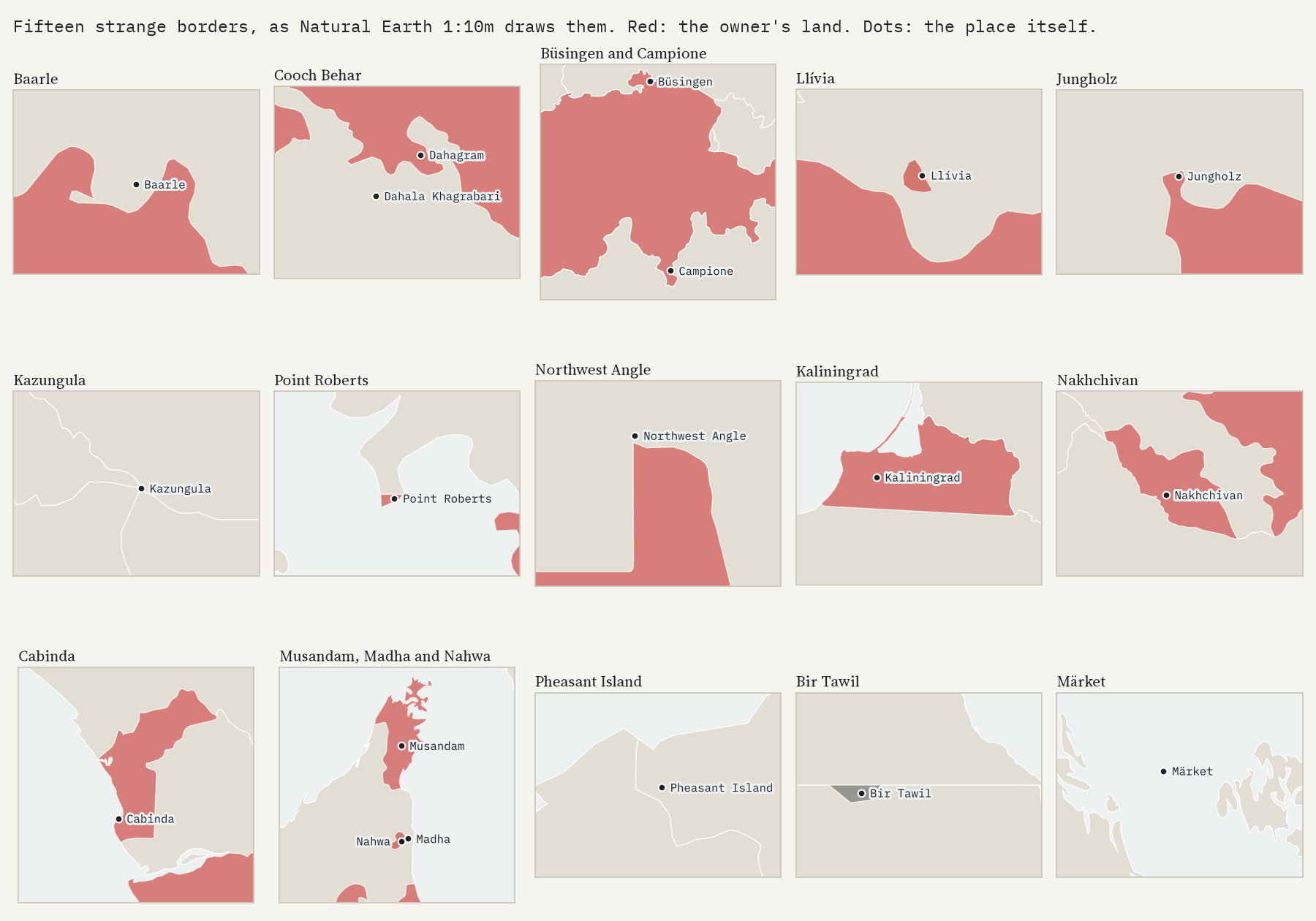
That town is Baarle. Medieval land deals between the Lords of Breda and the Dukes of Brabant, written down in 1843, left 22 pieces of Belgium scattered through the Netherlands, and 8 pieces of the Netherlands inside those or inside Belgium. The smallest Belgian parcel is 2,469 square metres. Wikipedia’s parcel tables have the border running through about 54 homes, and in one place through the middle of a front door, which has a Belgian house number and a Dutch one.
Until 2015 a farmer in Dahala Khagrabari lived in India, inside Bangladesh, inside India, inside Bangladesh.
Baarle is nothing next to what there was in Bengal. Wikipedia counts 102 Indian enclaves in Bangladesh and 71 Bangladeshi enclaves in India, with 21 and 3 counter-enclaves inside them, and one counter-counter-enclave: Dahala Khagrabari, 6,880 square metres of India in the middle of all that. 51,549 people lived in the enclaves in 2010. At midnight on 31 July 2015 the two countries swapped them; only Dahagram-Angarpota survives. Today the deepest nesting left is in the mountains of Arabia, where Nahwa, a village of the emirate of Sharjah, sits inside Madha, a piece of Oman, which sits inside the United Arab Emirates.
From a front garden to a kingdom
The smallest entry in Wikipedia’s list is Rückschlag, 16,000 square metres of Germany: a house and its garden. The largest true enclave on land is Uzbekistan’s Sokh inside Kyrgyzstan, 234 km². Then there are the three countries that are themselves enclaves: the Vatican and San Marino inside Italy, and Lesotho inside South Africa, 30,355 km², more than ten million times the size of Baarle’s smallest parcel.
Where three countries meet
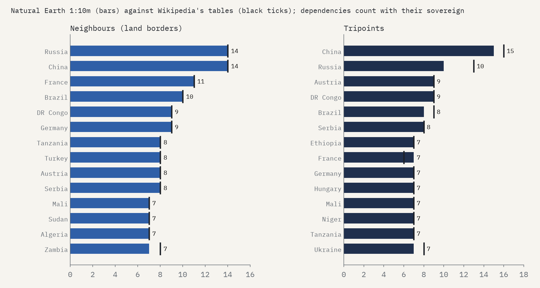
Natural Earth’s countries share their border points exactly, which means a computer can find every place where three of them meet. I count 167. China has the most, 15, and China and Russia also have the most neighbours, 14 each. On the number of neighbours, the map and Wikipedia agree for 150 of 160 countries, and the exceptions are oddities in their own right, like Canada and Denmark, which have shared a border only since they split Hans Island in 2022.
The map also finds one point where four countries meet, at Kazungula on the Zambezi: Botswana, Namibia, Zambia and Zimbabwe. On the ground it is not a quadripoint. According to Wikipedia, the four agreed in the late 2000s that Botswana and Zambia share a border about 150 m long, now crossed by a bridge. At the scale of the map, 150 m vanishes.
Landlocked, twice
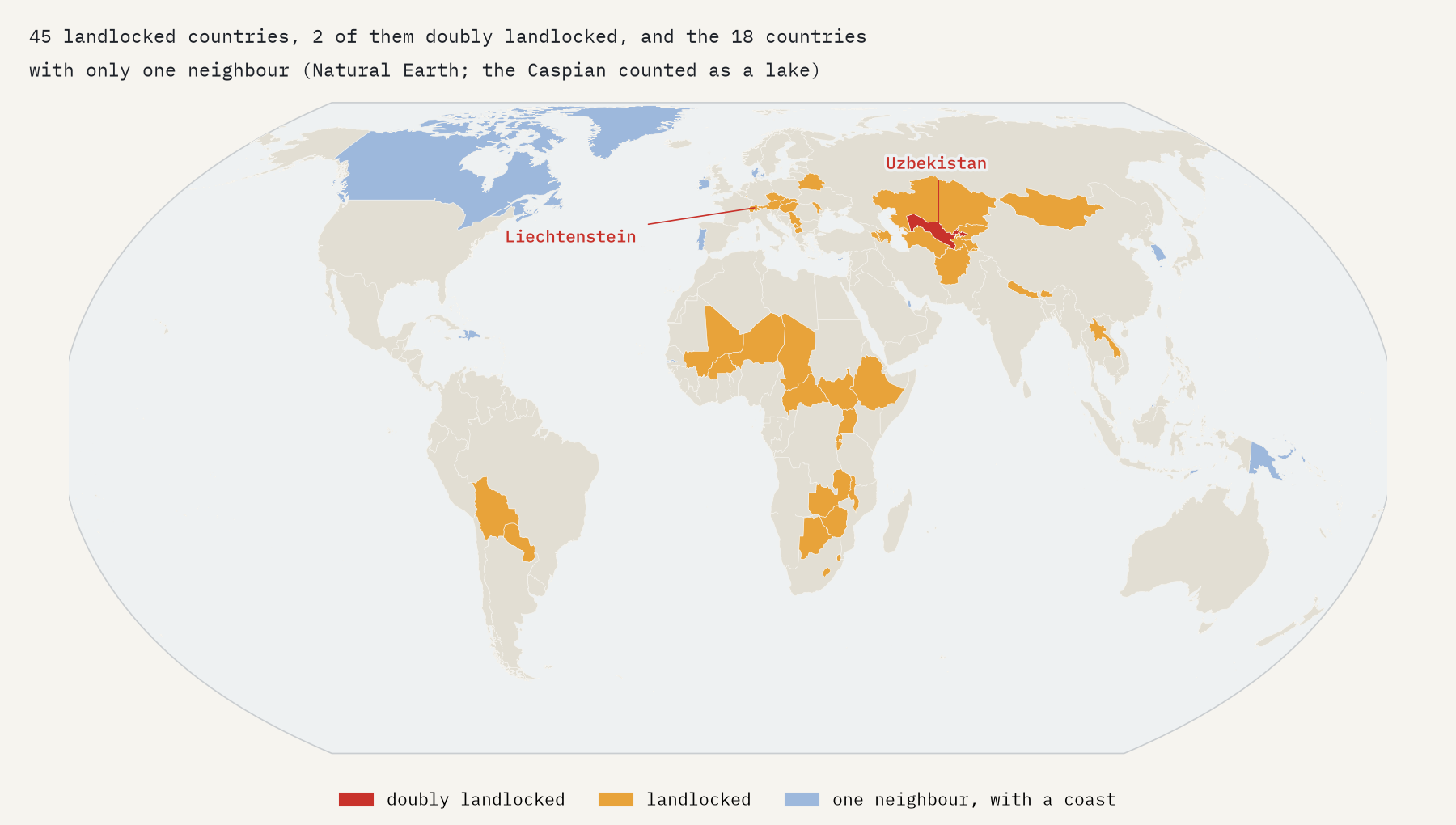
Counting the Caspian as a lake, 45 countries on the map have no coast. Two are doubly landlocked, with only landlocked neighbours: Liechtenstein, between Austria and Switzerland, and Uzbekistan, between Afghanistan, Kazakhstan, Kyrgyzstan, Tajikistan and Turkmenistan. To reach the sea from either you must cross at least two borders.
Shared, unclaimed, and too small to see
Pheasant Island, 6,820 square metres in a river between France and Spain, is French from August to January and Spanish from February to July, and has been shared since 1659. It has no pheasants. Bir Tawil, 2,060 km² of desert between Egypt and Sudan, belongs to nobody, because each country prefers the line that gives it the larger Halaib Triangle on the Red Sea. And Märket, a rock in the Baltic, has a border shaped like a backwards S, redrawn in 1985 so that its lighthouse would be in Finland.
Most of these places are too small for a world map. Of the 42 true enclaves, Natural Earth draws only 17 as separate pieces; Baarle, Büsingen and Campione are simply not there. What the map does contain, 50 detached pieces of countries that touch a neighbour, includes a couple that come from the drawing rather than the world. All the borders here are Natural Earth’s de facto lines and Wikipedia’s descriptions, and neither is an endorsement of any claim.
How I did this
I read Wikipedia’s List of enclaves and exclaves and 34 other articles, saved with their revision ids, and kept the national-level tables and lists. Places are put on the map from the list’s own coordinates, the infobox of each place’s article, or the Natural Earth piece that is the place. From Natural Earth’s 1:10m countries, grouped by sovereignty, I computed neighbours, border lengths, tripoints, detached pieces and landlocked status from the edges that countries share. The code checks every number in the text, and 98 quoted facts word for word against the articles. The paper sets out every step and caveat.
Notes and sources
- Wikipedia contributors, List of enclaves and exclaves and related articles (revision ids in the data), CC BY-SA 4.0.
- Natural Earth 1:10m countries and populated places (public domain). Wikidata (CC0).
- I wrote the text, with drafting and editing assistance from Claude (Anthropic), which also helped prepare the analysis code. I reviewed and checked all text and results.

