
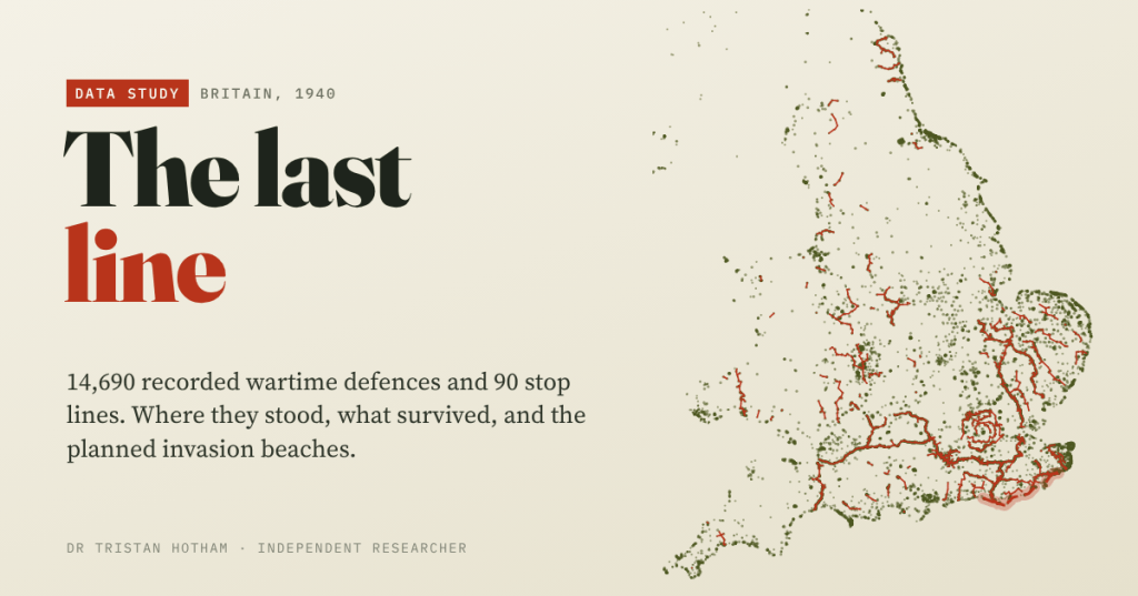
In the summer of 1940 Britain covered itself in concrete. Fifty years later, volunteers went out to find what was left. I mapped their 14,690 records to see where the defences were, how much survived, and whether they sat where the Germans planned to land.
If you walk the countryside of southern and eastern England for long enough, you will meet a pillbox. A squat hexagon of concrete in a field corner, a brick box by a river bridge, a row of anti-tank blocks half sunk in a hedge. They are so common that most people stop seeing them.
They are what is left of a frantic few months. After Dunkirk, with most of the army’s equipment left in France, Britain expected invasion and fortified everything it could. Beaches were wired and blocked. Bridges were mined. And inland, lines of pillboxes and anti-tank obstacles were strung across the country along rivers, canals and railway embankments. These were the stop lines, meant not to stop an invasion outright but to slow it until mobile forces could hit back. About 28,000 pillboxes and other hardened defences were built in all.
Between 1995 and 2002 the Council for British Archaeology ran the Defence of Britain Project, in which volunteers set out to record every wartime defence site they could find. Their database is open. I wanted to ask it three questions. Where were the defences? How much was still standing? And did they sit where the Germans actually planned to land?
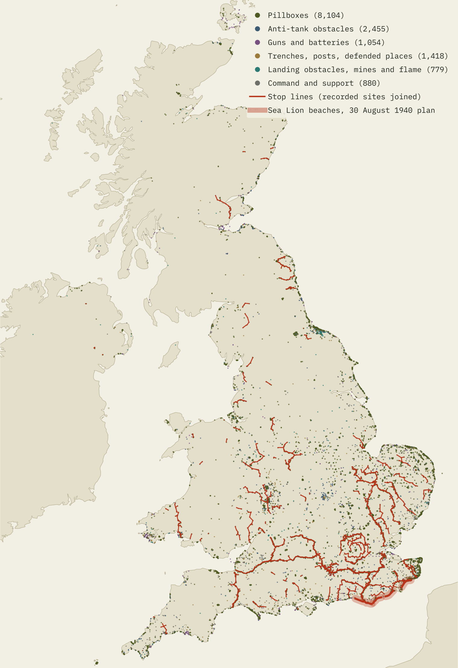
A country of pillboxes
The database has 14,690 sites with a location. Pillboxes dominate: 8,104 of them, 55% of the total. Next come 2,455 anti-tank obstacles: roadblocks, concrete cubes and cylinders, and the little pyramids called pimples that still line some field edges. Of the records with a construction date, 95% are dated 1940.
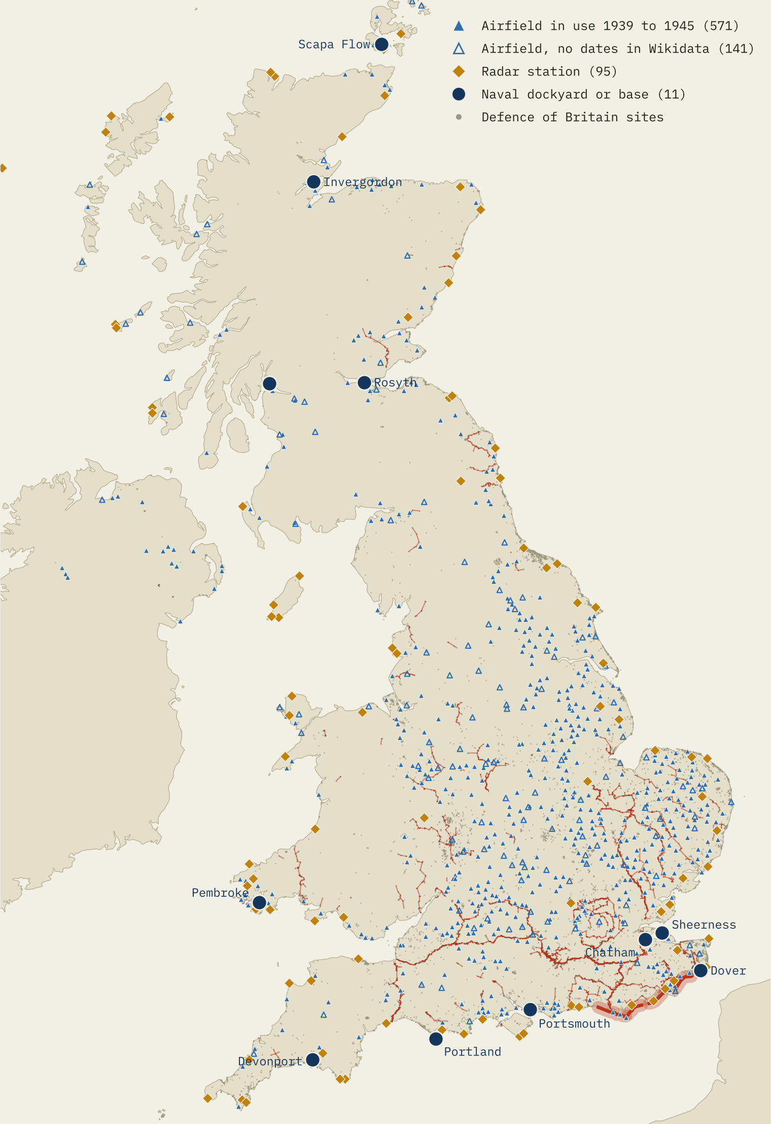
On the map the pattern is striking. There is a hard crust along the south and east coasts, a web of red stop lines across the south and east of England, and a set of rings around London. The biggest single line, the GHQ Line, was meant to shield London and the industrial heartland of England; its recorded sections hold 2,675 sites.
90 stop lines
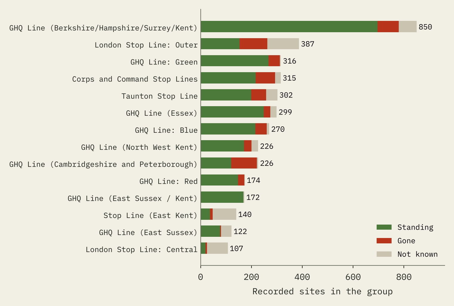
The volunteers grouped their records into named defences, including 90 stop lines with at least two located sites. Between them they hold 5,412 sites, 37% of everything recorded. The database does not say what order the sites ran in, so I drew each line by joining every site to its nearest neighbours, leaving out any gap of more than 10 km. That gives 3,929 km of line, which is a floor: some lines were walked end to end by recorders and others barely at all.
The largest is the GHQ Line through Berkshire, Hampshire, Surrey and Kent, with 850 recorded sites. The Taunton Stop Line, built to seal off the south-west peninsula, has 302.
What survived
Each site was given a condition when it was visited. 8,575 sites (58%) were still standing in some state, 3,528 had been removed or filled in, and 2,587 were of unknown condition. Leaving out the unknowns, 71% survived.
What survived depends on what it was. Pillboxes are hard to shift and usually out of the way, and 81% of those with a known condition were standing. Anti-tank obstacles in roads and towns fared worse, at 56%. Beach scaffolding, anti-landing obstacles, minefields and flame traps were cleared after the war on purpose, and only 12% remained. Stop lines held up better than the rest: 81% of their sites with a known condition were standing, against 65% elsewhere.
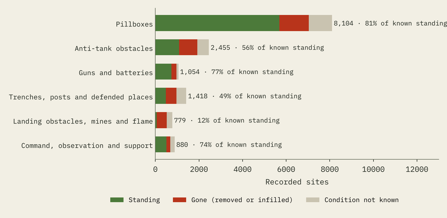
The volunteers recorded 5,693 standing pillboxes. That is close to the often quoted figure of about 6,500 survivors, which is no surprise, as that figure comes largely from this survey.
Did they defend the right beaches?
The German invasion plan, Operation Sea Lion, went through many drafts. In the version adopted on 30 August 1940, as summarised on Wikipedia, the first wave would land on four stretches of beach: Folkestone to New Romney, Rye to Hastings, Bexhill to Eastbourne, and Beachy Head to Brighton. I traced those 81 km of coast and compared them with the rest of the south and east coast from Land’s End to Berwick-upon-Tweed.
Within 10 km of the landing beaches the volunteers recorded 5.6 sites per km of coast. Along the rest of the south and east coast the figure is 2.5. So the planned landing coast carried 2.3 times the density of recorded defences, and 3.1 times for pillboxes. It holds whether I look within 5 km or 20 km.
The beaches the Germans chose were more heavily defended than the average coast. They were not the most heavily defended coast.
Look more closely and the picture changes. Almost all of the lead comes from the eastern end, Folkestone to New Romney, with 11.3 sites per km. Rye to Hastings has 2.2, no more than an ordinary stretch of coast. The densest defence on the south coast is the stretch from Folkestone to Dover, opposite France. That looks less like the British guessing the German plan than like a defence of the obvious: the narrowest crossing first, every usable beach after.
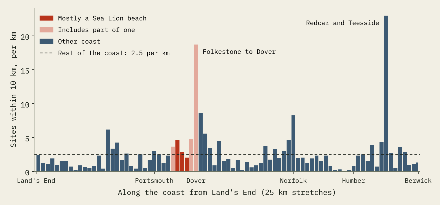
The tallest bar of all is a warning. It is Teesside, around Redcar. The heavy industry of the Tees was defended, but Redcar and Cleveland also had busy recorders: it has 628 records, more than Devon’s 288. This is a map of what volunteers found, and some places had far more volunteers than others.
The wider war
Pillboxes were one layer of a much bigger system, so I added airfields, radar and the navy. Wikidata lists 745 airfields and RAF stations in the UK; 571 have dates that place them in use during the war. Airfields were an obvious target for paratroops, and 14% of recorded pillboxes stand within 2 km of one. The Sea Lion plan named one directly: the airborne division was to seize the aerodrome at Lympne. I also mapped 95 radar stations, most from the Wikipedia list of Chain Home sites, and the 10 naval dockyards working in the war, from Portsmouth and Devonport to Rosyth and Scapa Flow.
Still there?
The survey is now a quarter of a century old, so I checked it against OpenStreetMap. Only 13% of recorded pillboxes have a pillbox mapped within 50 m today. That says more about the map than about the pillboxes: most surviving ones simply have not been added yet. If there is one near you, it may be worth putting on the map.
How I did this
I used the Defence of Britain database from the Archaeology Data Service: site types, condition, named groups and counties, with coordinates from the service’s Google Earth file of the dataset, checked against the database’s own grid references. I grouped the 162 site types into six families. Stop lines are drawn as a minimum spanning tree through each group’s recorded sites. For the coast test I placed the towns named in the Sea Lion plan from the Ordnance Survey gazetteer, traced the coast between them on a Natural Earth coastline, and counted sites within 10 km of it per km of coast, against the rest of the south and east coast. Airfields, radar stations and naval bases come from Wikidata and Wikipedia, and pillboxes mapped today from OpenStreetMap.
The limits matter. This is a map of what was recorded, mostly between 1994 and 2002, not of everything that was built, and recording effort varied hugely between counties. Conditions were judged on a single visit and have changed since. Wikidata and OpenStreetMap are uneven too. And the Sea Lion beaches were a German plan the defenders never saw.
Notes and sources
- Defence sites: Defence of Britain Archive, Council for British Archaeology (2002, updated 2006), Archaeology Data Service, https://doi.org/10.5284/1000327. Data copyright Council for British Archaeology unless otherwise stated; reused for non-commercial research with acknowledgement. Derived data under CC BY-NC 4.0. No personal data are used.
- Airfields, radar stations, batteries and naval bases: Wikidata (CC0). Pillboxes mapped today: © OpenStreetMap contributors (ODbL).
- Wikipedia (CC BY-SA 4.0): Operation Sea Lion, British anti-invasion preparations of the Second World War, GHQ Line, Chain Home and Royal Navy Dockyard.
- Places: Ordnance Survey, OS Open Names. Contains OS data © Crown copyright and database right 2026 (Open Government Licence v3.0). Coastline: Natural Earth.
- Paper, data and code: Zenodo and GitHub. Related: Fire on the Hills, on an earlier warning system along the same coasts.
- I wrote the text, with drafting and editing assistance from Claude (Anthropic), which also helped prepare the analysis code. I reviewed and checked all text and results.

