
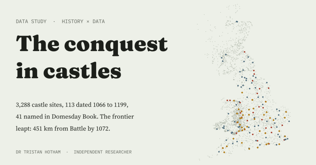
After Hastings the Normans held England with earth, timber and then stone. I mapped every Norman-type castle site Wikidata knows in Britain to see how fast the castle frontier moved. The answer: it did not creep. It leapt.
Castles are the shorthand for the Norman Conquest: a mound, a timber tower, a ditch, and a garrison looking down on an English town. Thousands survive, from the Tower of London to grassy humps in Herefordshire fields. I wanted to see the Conquest as a map that grows, decade by decade from 1066.
Wikidata, the open database behind Wikipedia, holds 3,288 castle sites of the Norman kinds in England, Wales and Scotland: 958 mottes and motte-and-bailey castles, 162 ringworks, 10 keeps and 2,158 sites classed simply as castles. The problem is time. Only 317 of them have any date at all, and just 113 are dated between 1066 and 1199. So this became a story told twice: once with the few castles that carry a date, and once with the many that do not.
Most castles have no date
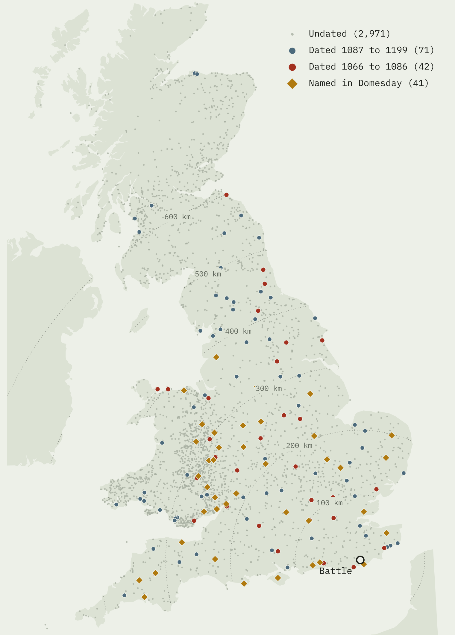
The grey dots are the real castle landscape of the Conquest: 2,971 sites with no date. The coloured ones are the minority that Wikidata can date. And they are not a fair sample. In England and Wales, 60% of the dated sites are Grade I listed buildings, against 6% of the undated ones. Only 15% of dated sites are earthworks, against 43% of the rest. Wikidata dates the big stone and royal castles and leaves 972 mottes and ringworks without a year.
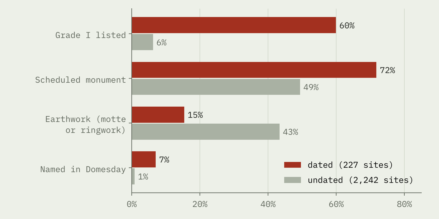
Even Hastings Castle has no date in Wikidata. Nor do Cambridge, Gloucester, Richard’s Castle or Penwortham, all of which Domesday Book shows standing in 1086. The one piece of good news is that the bias is about kind, not place: the median dated site is 282 km from the battlefield, the median undated one 293 km. So the dated castles can tell us how far and how fast, if not how many.
A frontier that leapt
If the Normans had advanced like a slow tide, castle dates would get later the further you go from Battle. They do not. Of the 32 castles dated 1066 to 1072, 8 were already more than 300 km away. York Castle is dated 1068, 354 km north; Durham 1072, 451 km. In England and Wales the link between year and distance is weak (Spearman 0.12) and not statistically clear.
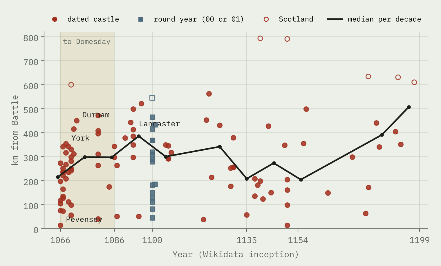
The median dated castle was 235 km from Battle in 1066 to 1071, 327 km in 1072 to 1086 and 297 km in 1087 to 1135. After that it falls back to 202 km, as building filled in nearer home.
The castles did not follow the conquest outwards. They were the conquest, planted at once in the county towns of the whole kingdom.
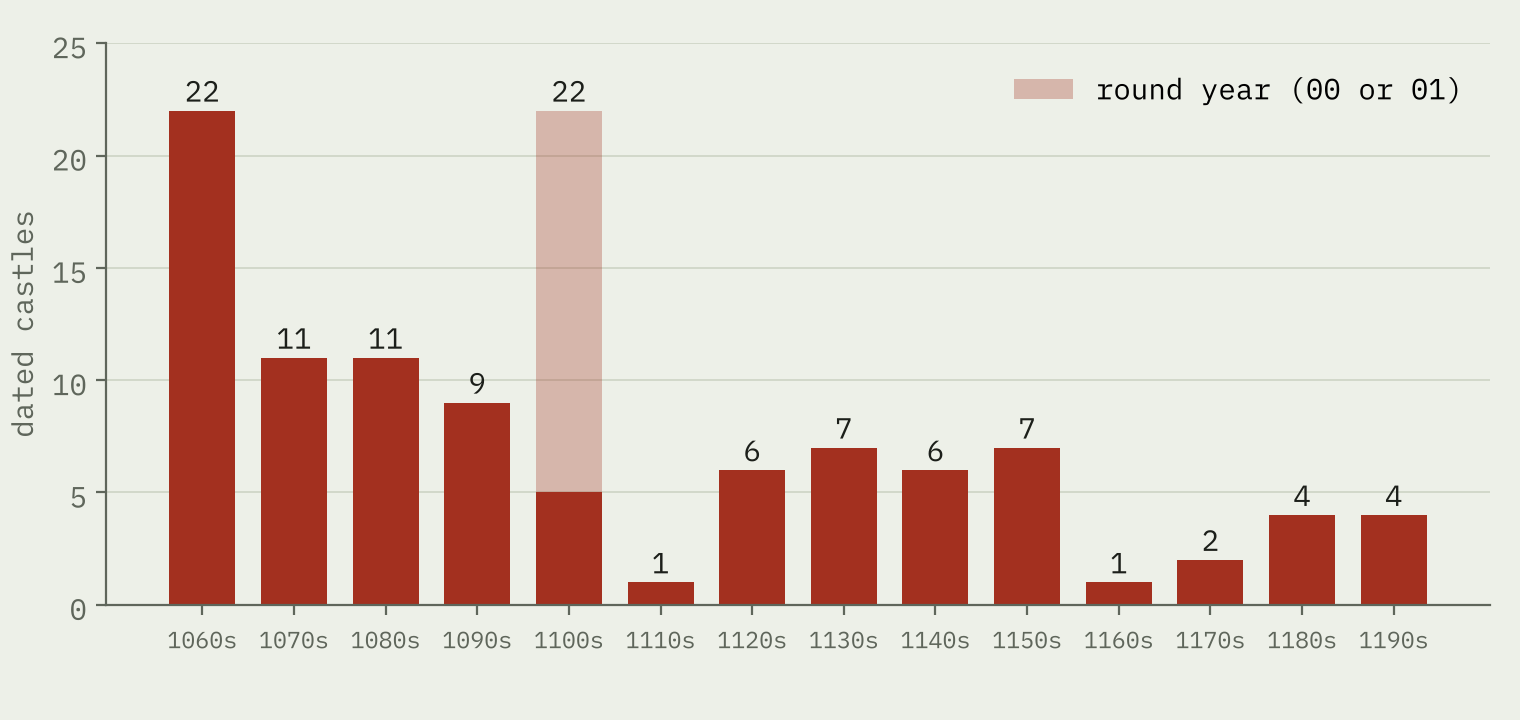
The 1060s are the busiest decade in the record, with 22 castles in four years. The 1100s look as busy, but 17 of their 22 dates are 1100 or 1101, which in Wikidata can simply mean “twelfth century”.
What Domesday says it cost
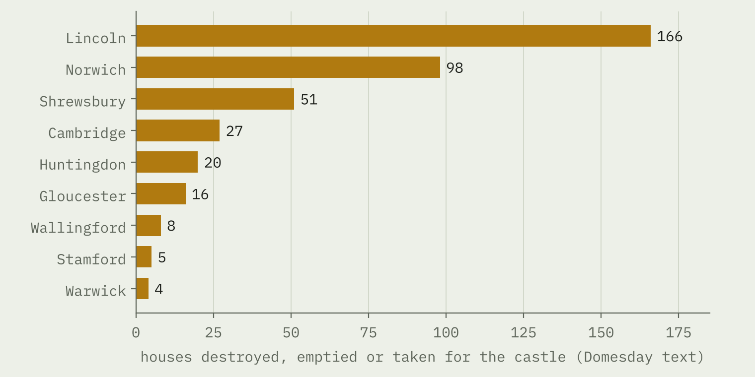
Domesday Book, compiled in 1086, is the one witness from the time. I read every entry the Hull Domesday Project flags as mentioning a castle and kept those where the text really speaks of a castle at that place, not just a modern name like Castle Hedingham. That leaves 41 castles. In the towns, Domesday counts the houses they replaced: 395 across 9 towns. At Lincoln, “166 were destroyed because of the castle”. At Shrewsbury “the Earl’s castle has taken over 51 messuages”.
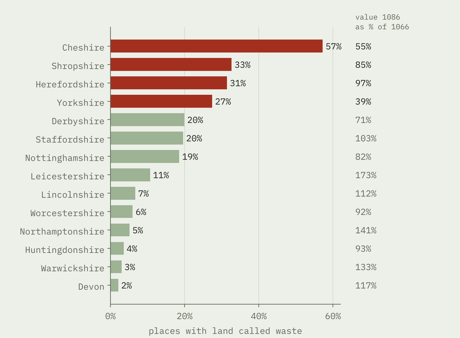
In the countryside the damage is regional. Cheshire tops Domesday’s list of waste, with 57% of places touched, then Shropshire, Herefordshire and Yorkshire. Yorkshire, harried by William in 1069 and 1070, was worth 39% of its 1066 value in 1086. Wigmore and Clifford castles were, in Domesday’s words, built “on waste land”.
But I found no clear ring of damage around each castle. Within the same county, places within 5 km of a castle standing by 1086 carry only 1.5 percentage points more waste than the rest, and their median value barely moved. The cost of castles shows up in town streets and in whole regions, not field by field.
The Welsh March: castle country
Put the dated and undated sites together and one region stands out. A band 40 km either side of the border between England and Wales covers 15% of the land of the two countries but holds 35% of their castle sites: 3.2 times the density of the rest. Herefordshire has 72.9 castle sites per 1,000 km², the highest of any county.
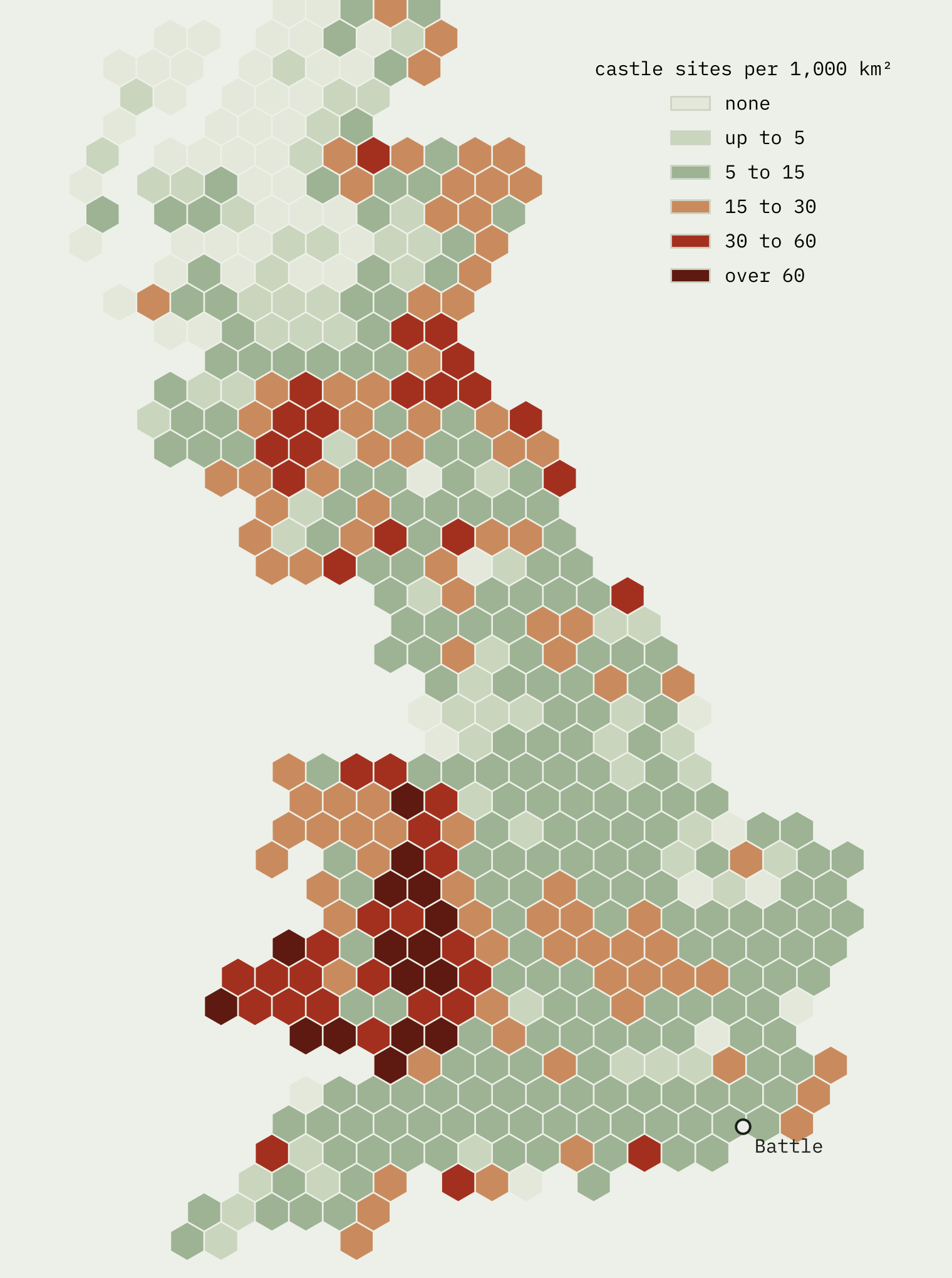
Two cautions. Wikidata’s Welsh records may simply be fuller, and its Welsh “castles” include castles of the Welsh princes. But counting only mottes and ringworks, the border band is still 3.3 times as dense.
Lancashire: late, but not that late
The north-west is thin castle country, with 6.2 sites per 1,000 km² in Lancashire. The first dated castles are of the 1090s: Brough, Carlisle and Lancaster (1093). Clitheroe’s Wikidata date is 1200, a round year. But Domesday’s entry for Penwortham, on the Ribble, ends: “Now there is a castle.” So the Normans had a castle in Lancashire by 1086, before any date in the dated record.
How I did this
Castles come from a Wikidata extract retrieved on 27 October 2026, deduplicated by item and limited to castle, motte, motte-and-bailey, ringwork, keep and related classes in England, Wales and Scotland. Every date is the earliest Wikidata inception; I added none. Years ending in 00 or 01 are flagged, because Wikidata stores century dates as years. Domesday comes from the Hull Domesday Project’s coding via the realm-domesday repository. Distances are straight lines from Battle, East Sussex. OpenStreetMap’s castles served as a coverage check: 64% of them sit within 1 km of a Wikidata site, but only 27% of Wikidata sites have an OpenStreetMap castle nearby, because the earthworks come from heritage lists.
Scotland is in the map but treated as context: it was not conquered, and most of its Wikidata castles are later tower castles.
Notes and sources
- Wikidata (CC0), castle items retrieved 27 October 2026
- Hull Domesday Project data, Professor J.J.N. Palmer, George Slater and the University of Hull (CC BY-NC-SA)
- realm-domesday repository by embabel-worlds
- Open Domesday by Anna Powell-Smith
- OpenStreetMap contributors (ODbL)
- ONS boundaries and OS Open Names, Open Government Licence v3.0; contains OS data © Crown copyright and database right 2026
- The paper, with full methods and limitations
I wrote the text, with drafting and editing assistance from Claude (Anthropic), which also helped prepare the analysis code. I reviewed and checked all text and results.

