
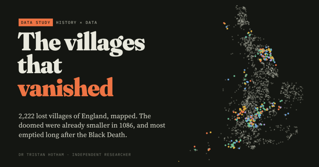
England is scattered with the ghosts of villages: house platforms under sheep pasture, a church alone in a field, a name that lingers on old tax rolls. I mapped all 2,222 in the national gazetteer and set them against Domesday Book. The doomed were already smaller in 1086, and most of them emptied long after the Black Death.
Walk across a pasture on the Yorkshire Wolds or in Northamptonshire on a low winter afternoon and the ground starts to talk. A sunken lane runs between grassy banks. Low rectangles of turf mark where houses stood. Ridge and furrow, the ploughland of a vanished open field, runs right up to the edge of it all. These are deserted medieval villages, and England has thousands of them.
Everyone thinks they know what happened: the Black Death came in 1348, the villagers died, the village was gone. I wanted to test that against the record itself. The University of Hull has turned Maurice Beresford and John Hurst’s 1968 gazetteer of lost villages into an open database, with a location for every site and, for some counties, its full paper trail from Domesday Book to the 1841 census. My question was simple. Where are they, what were they like before they emptied, and when does the record say they went?
A belt of loss
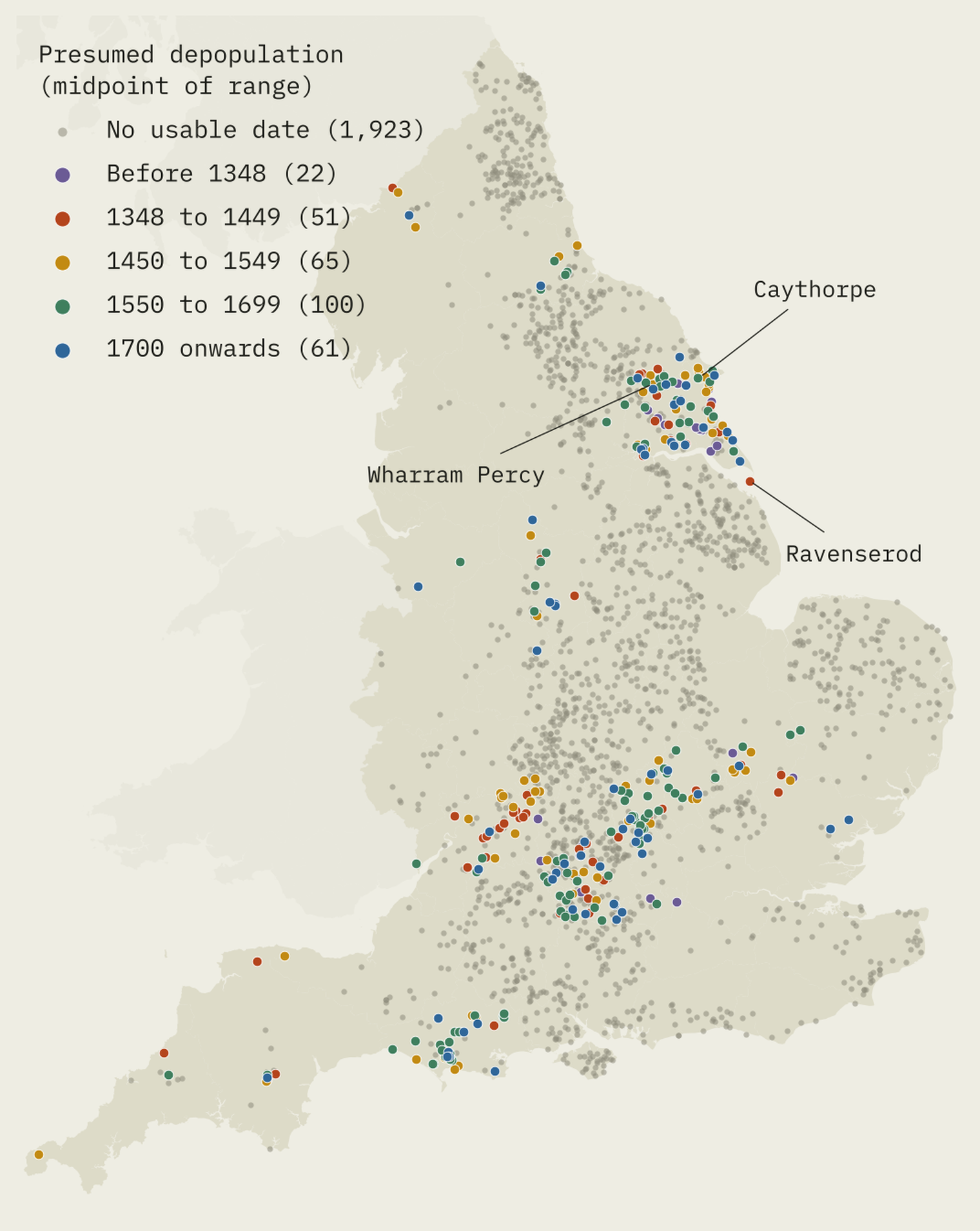
The gazetteer lists 2,222 sites, 2,074 of them deserted villages or hamlets. The most are in Yorkshire (374), Lincolnshire (220) and Northumberland (165). But raw counts mix how many villages a county had with how hard people looked. So I matched the lost sites to the places named in Domesday Book and asked a fairer question: what share of each county’s Domesday places later vanished?
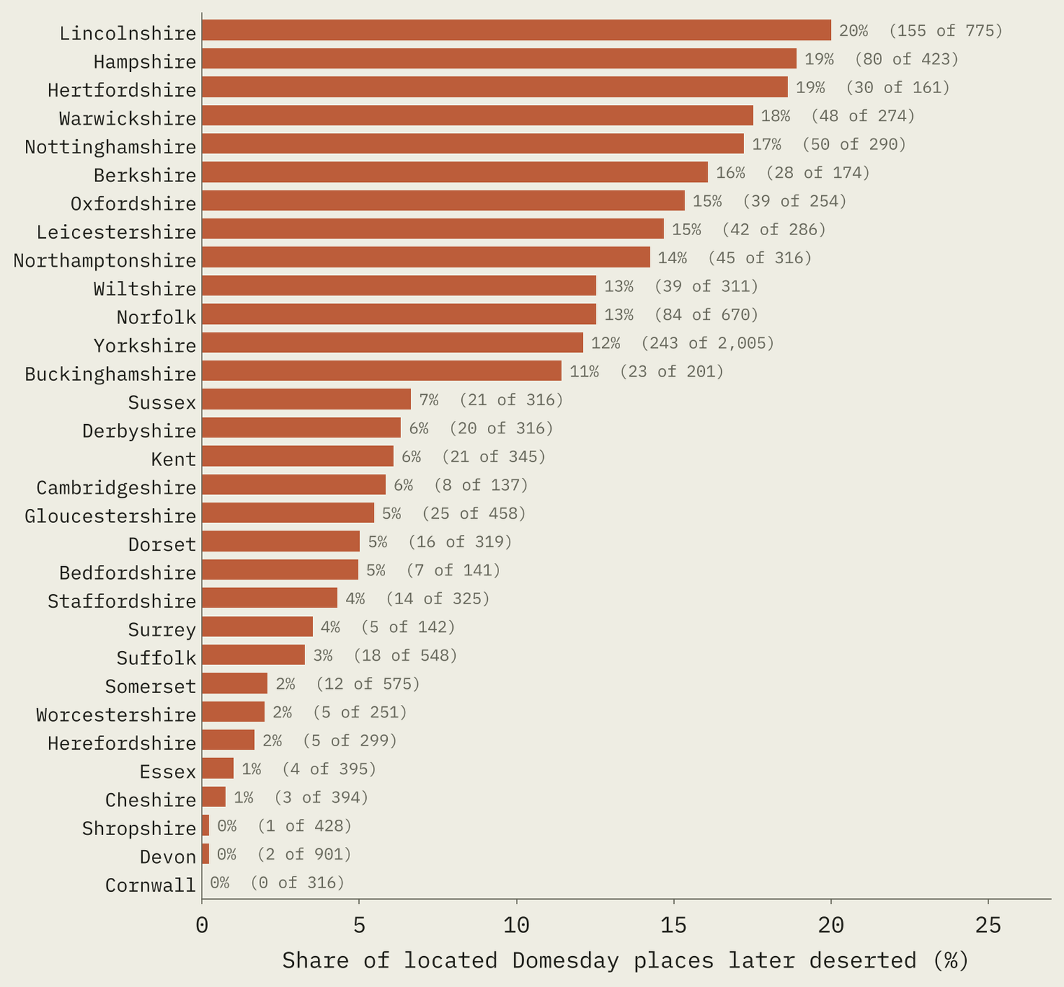
In Lincolnshire, one Domesday place in five is now a lost village. In Hampshire, Hertfordshire, Warwickshire and Nottinghamshire it is nearly as many. In Cornwall, Devon and Shropshire it is almost none. That is the old map of English farming: the losses run through the champion country of big nucleated villages and open fields, not the west, where people lived in scattered hamlets and farms.
Doomed in 1086?
This is the part I most wanted to see. Domesday Book lets us look at these villages three centuries before most of them emptied. Of the Domesday places I could match, 1,110 later became deserted villages or hamlets and 11,819 did not.
The doomed were smaller. The median deserted place had 13 households in 1086, against 17 for the places that survived. That holds within counties too: 72% of the doomed places were smaller than the middle place in their own county. But they were not the tiniest.
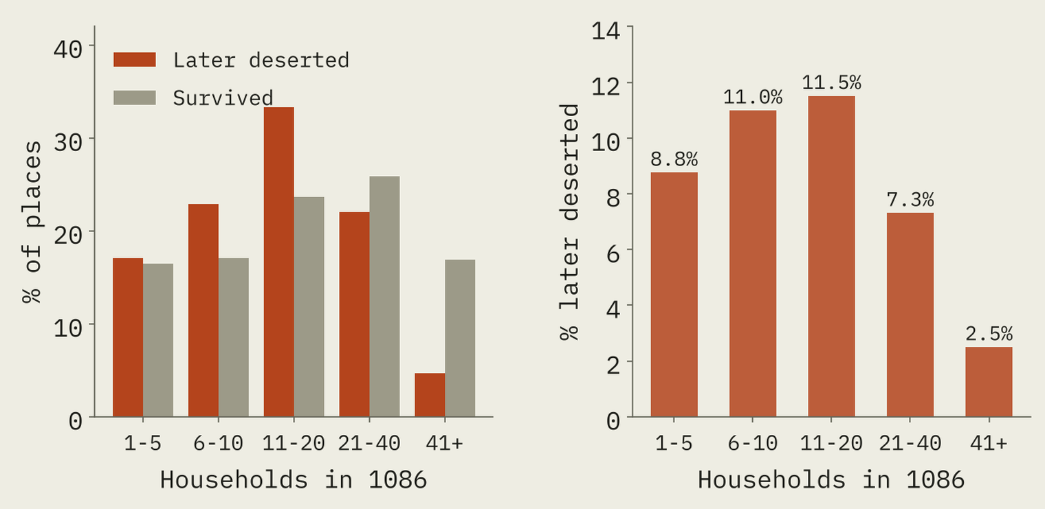
The risk peaked in the middle. About 11% of places with 6 to 20 households later vanished, against 2.5% of places with more than 40. Big villages almost never went. Per household, the doomed places had the same plough teams as everyone else. They were not bad farms. They were ordinary, smallish communities, with less to hold on with when hard times came.
Nor were they stuck on poor land. I measured the height, the steepness of the ground, the distance to the nearest stream and to the nearest Roman road for every Domesday place. Within each county, the doomed places were almost exactly typical on all of them.
The villages that vanished were not marginal places. They were ordinary, smallish villages in good farming country.
After the plague, not because of it
For 308 sites the record gives a presumed date of depopulation. Most are broad ranges (“1350-1450”, “15th-16th century”), so I spread each one evenly across its range and added them up, decade by decade.
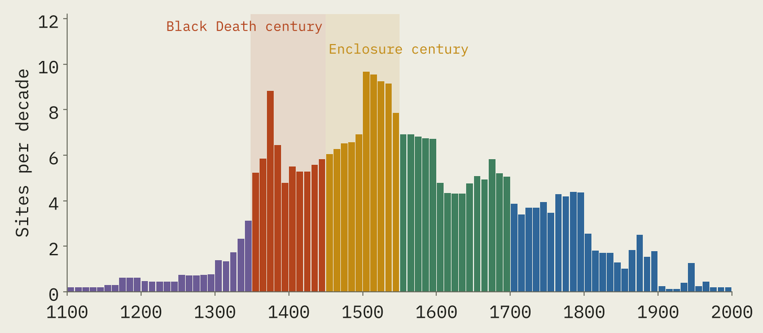
The Black Death leaves a mark: a jump in the decades after 1348. But only 20% of the dated weight falls in the century from 1348 to 1449. In all, 74% falls after 1450. The busiest decade is the 1500s, the age of the great enclosure complaints, and a good share comes later still, as villages were cleared for landscape parks or enclosed by Act of Parliament.
Wharram Percy, the most famous lost village of all, tells the story in miniature. Its record notes 30 farmhouses and cottages in 1368, after the plague had struck, and only 16 by 1435. The end came as the land went over to pasture. The final stage of that conversion is dated to 1527.
Watching villages fade from the tax rolls
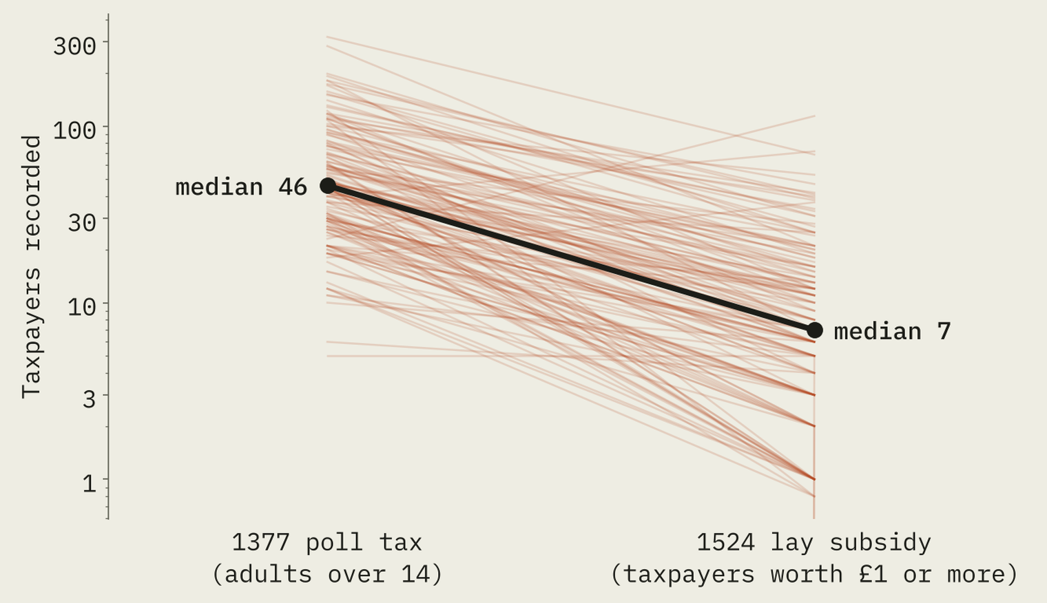
The tax records let us watch the thinning. Of the villages taxed in 1377, 30% are not recorded at all in the subsidy of 1524. For those with a count in both, the median fell from 46 taxpayers to 7. The two taxes are not like for like (the 1524 subsidy missed the poorest), so I would not read a rate of decline into that. But the direction is plain.
The names outlived the houses. For 93% of the sites with a last document in the National Archives’ tax database, that document is after 1600. A township went on paying tax as a unit long after its village was grass.
What the record says
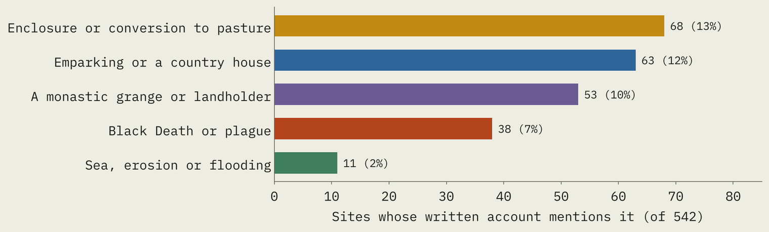
For 542 sites the gazetteer has a written account. Enclosure and pasture come up most (68 sites), then emparking (63) and monastic landholders (53). The plague comes up for 38. At Caythorpe in the East Riding, depopulation “was reported in 1517 with 20 residents and five houses removed as a result of the enclosure of 300 acres for sheep pasture”. A few were lost to water: Ravenserod, a medieval port on the shifting sands of the Humber, was two-thirds destroyed by 1346, and Derwent in Derbyshire was drowned by a reservoir in the 1940s.
So the plague weakened many villages. But the record suggests that what finished most of them was the later economy of the countryside: sheep, parks and landlords.
How I did this
All 2,222 sites come from Beresford’s Lost Villages (University of Hull, CC BY-NC-SA 4.0), read from its public map service. Its tax and census fields are free text, so I parsed each into a number and a status, keeping “not recorded” apart from “no surviving record”. I matched sites to Domesday places by name within 5 km, using the Hull Domesday Project data as prepared for my earlier Is Domesday Destiny? study, and left out ambiguous matches such as a “Little” village meeting a plain Domesday name. Height comes from AWS Terrain Tiles, streams from OS Open Rivers and Roman roads from Itiner-e.
The limits matter. The gazetteer is the 1968 list, and the Hull team expects later finds to at least double it. Dates, descriptions and scheduled status exist only for 14 counties (540 sites), which do not include Lincolnshire or the east Midlands, where losses were heaviest. Dates are the record’s judgement and often a century wide. Domesday counts heads of household on manors, not people in villages.
Notes and sources
- Lost villages: Beresford’s Lost Villages, University of Hull (CC BY-NC-SA 4.0), based on the 1968 gazetteer in M. Beresford and J. G. Hurst (eds), Deserted Medieval Villages (1971). Quotations are from its site descriptions.
- Domesday: Hull Domesday Project data, Professor J.J.N. Palmer, George Slater and the University of Hull (CC BY-NC-SA), via the realm-domesday repository; place links from Open Domesday by Anna Powell-Smith.
- Setting: AWS Terrain Tiles (Mapzen/Tilezen); OS Open Rivers, contains OS data © Crown copyright and database right (OGL v3); Roman roads from Itiner-e (de Soto, Pažout, Brughmans and others 2025, CC BY 4.0).
- Paper, data and code: Zenodo and GitHub. Data and text CC BY-NC-SA 4.0; code MIT.
- I wrote the text, with drafting and editing assistance from Claude (Anthropic), which also helped prepare the analysis code. I reviewed and checked all text and results.

