
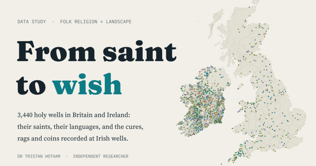
Throw a coin in a well and make a wish. Where did that come from? I mapped 3,440 holy wells in Britain and Ireland, read the saints and languages in their names, and counted the cures, rags and coins recorded at Irish wells.
Most of us have dropped a coin into a well at some point: at a garden centre, in a shopping arcade, at the edge of a pond in a park. It is a small, half-serious ritual. But for a thousand years and more, people in Britain and Ireland came to springs named for saints. They walked rounds on the saint’s day, prayed, drank the water or bathed sore eyes in it, and left something behind: a rag tied to a thorn tree, a pin, a medal, a coin.
In my earlier map of saints and holy wells across Western Europe I looked at whose churches are whose. This time I wanted to follow the wells themselves, from the saint’s well to the wishing well, using the best open records I could find for Britain and Ireland.
Every holy well I could find
The Republic of Ireland has something no other country here has in open form: an official inventory of holy wells. The National Monuments Service records 3,025 of them, each with a location, the name on the old Ordnance Survey maps, and the opening of an archaeological description. For Northern Ireland, Britain and the Isle of Man I had to rely on volunteers. I filtered 66,517 OpenStreetMap features with well-like names (Wellington Road, Bridewell and a great many pubs among them) down to 415 holy wells, with Wikidata filling a few gaps.
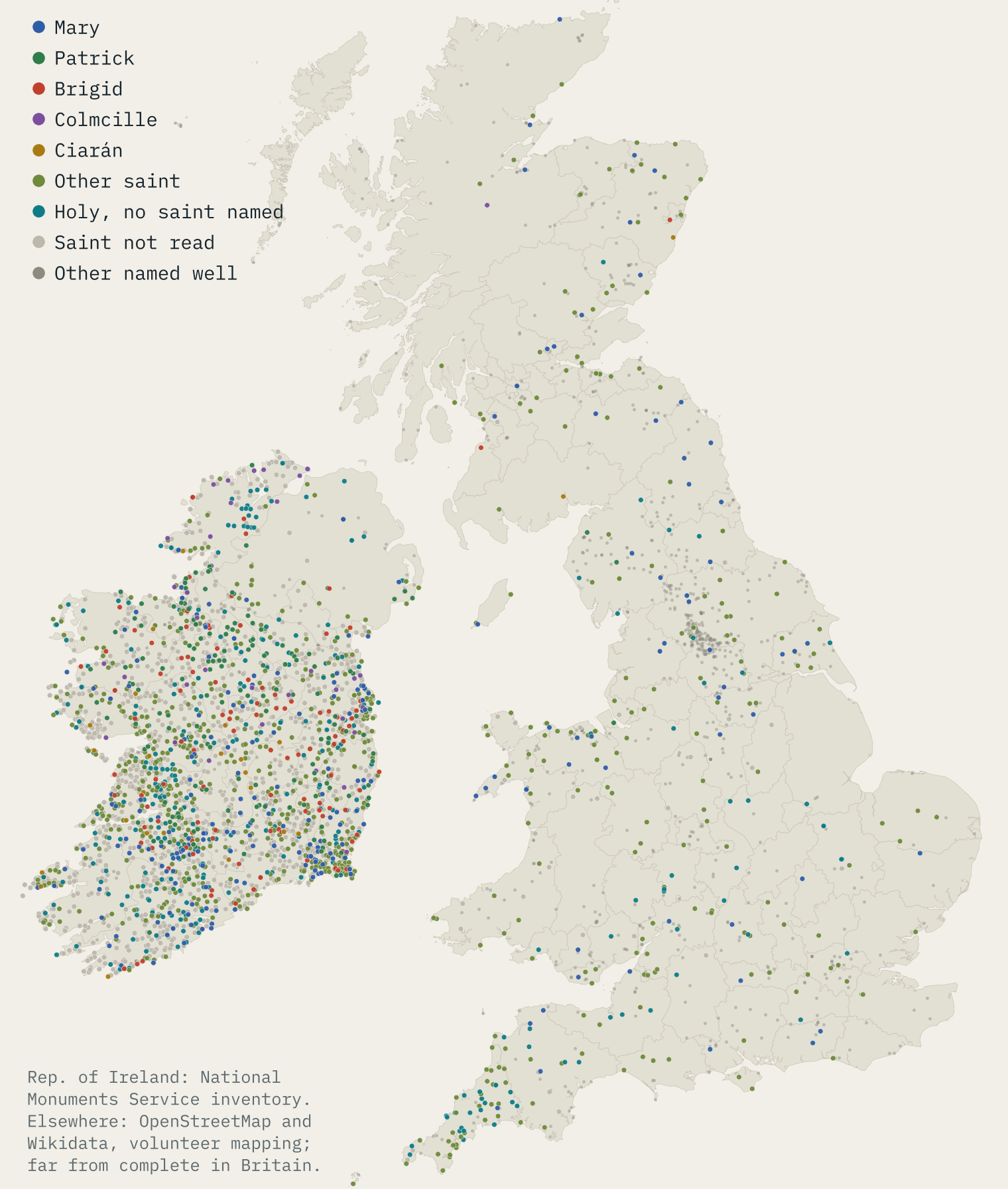
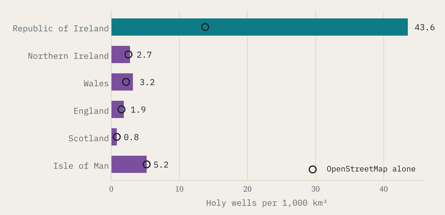
The map looks as if Ireland is full of holy wells and Britain nearly empty. Be careful. The Republic has 43.6 recorded holy wells per 1,000 km². Northern Ireland, which shares the same tradition, shows only 2.7, about one sixteenth as many. The wells did not stop at the border; the record did. So Britain’s 373 mapped holy wells are a floor, not a count. Even so, the open data pick out Cornwall, with 57 mapped holy wells, far more for its size than any other British county.
Mary, Patrick and Brigid
A well’s name often tells you whose it is: St Patrick’s Well, Toberbride, Ffynnon Fair. I only counted a saint where the name says so plainly, in English, Irish or Welsh. Of the 2,142 named Irish wells, 1,007 name a saint. Mary (162) and Patrick (161) are in a dead heat, and Brigid is third (113). Behind them come John, Colmcille, Brendan and Ciarán, and then a long tail of local founders, 189 names in all, from Mac Duagh to Gobnait.
That is different from my earlier map, where Brigid led with 23% of named Irish wells. That figure came from the 1,021 Irish holy wells in Wikidata. With the full inventory Brigid’s count hardly moves, but Mary and Patrick have far more wells, so her share falls to 11%.
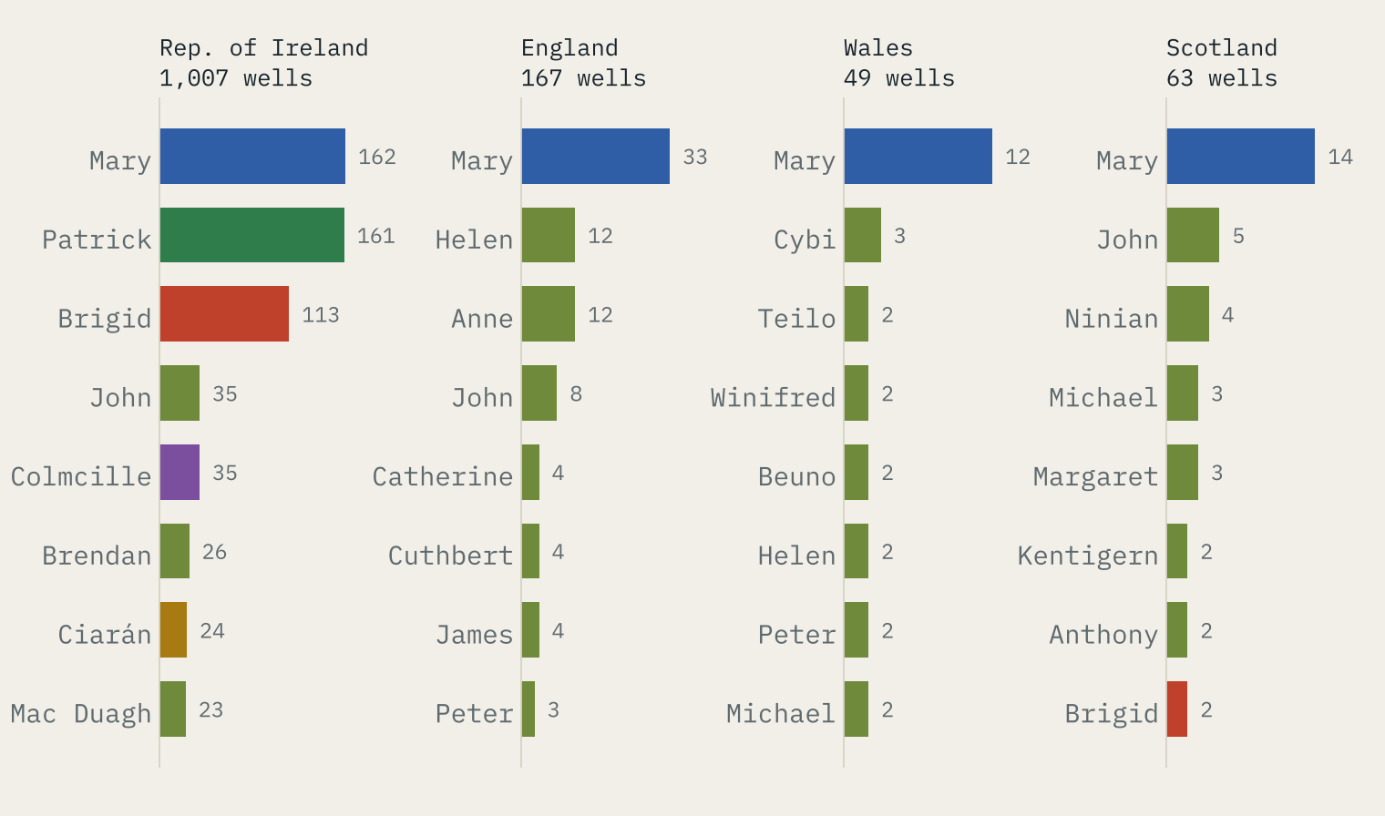
In Britain, Mary leads in England, Wales and Scotland. Below her the saints are local: Helen and Anne in England, Cybi, Teilo, Winifred and Beuno in Wales, Ninian and Kentigern in Scotland.
Well, tobar, ffynnon
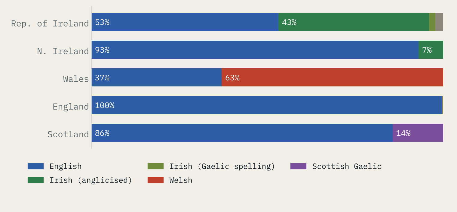
The word for well carries its own map. In the Republic, 45% of named holy wells have Irish names, nearly all in the anglicised spellings of the nineteenth-century surveyors: Toberbride, Tubbrid, Tobermore. In Wales 63% of named wells are a Ffynnon, and in Scotland 14% are a Gaelic Tobar or Fuaran. Oddly, the saints mostly travel in English: only 23% of Irish wells with a saint have an Irish form of the name.
From saint to wish
This is the part I most wanted to see. The Irish descriptions record what happened at the wells. I searched them for the words that mark each practice, ignoring mentions like “no votive offerings” or “no devotions now”. There is a catch: the open data only hold the first 254 characters of each description, and most are cut off there. So everything below is a floor.
Even in those opening lines, 19% of the 2,628 described wells mention a cure, rags, offerings or a pattern day. Patterns, pilgrimages and rounds are the most common (12%). Cures come next (5.3%), and the commonest ailment is the eyes: 52 wells, many called Tobar na Súl, the well of the eyes. Rags appear at 32 wells, offerings at 74, and coins at 14.
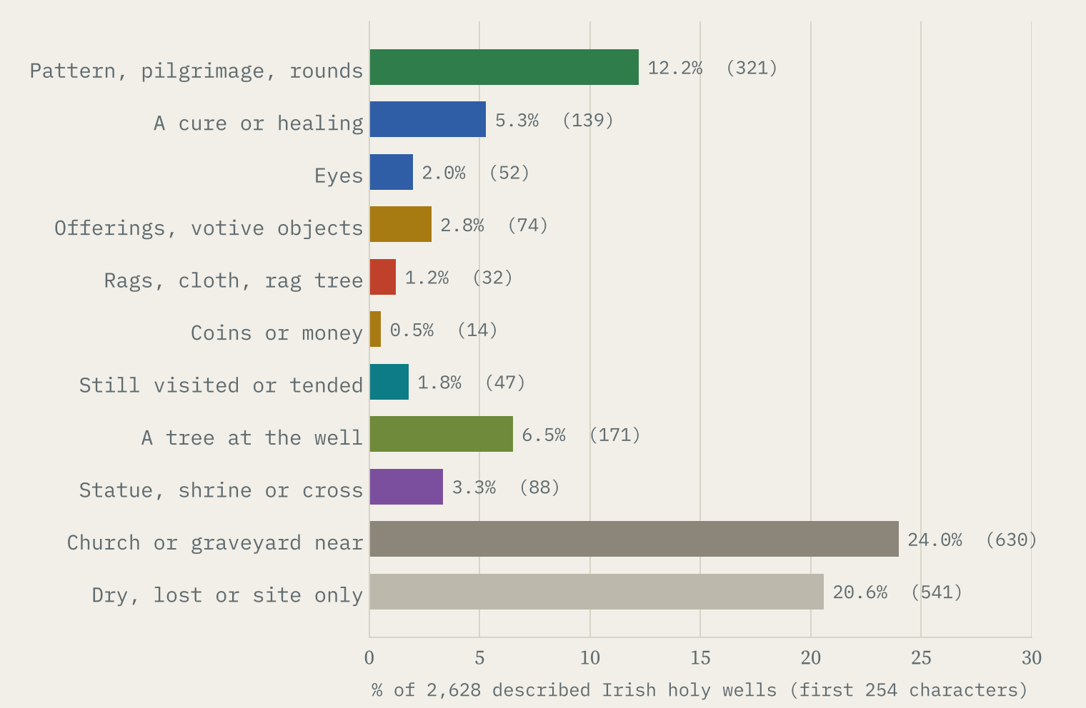
The records are vivid. One Kilkenny well was known as Tobar na nGiobog, “the Well of the Rags, from the quantity of rags left there formerly and still by its votaries”. At a Cork well a tree beside the water “has coins inserted”. At St Patrick’s Well in Limerick there were “coins dropped into the water”.
The wishing well’s coin was already there at the saint’s well.
And the wishing well itself? As a name on the map it has mostly left the holy well behind. Of 81 OpenStreetMap features called “Wishing Well”, only 38 are actual wells or springs. The rest include 13 pubs, cafes and restaurants and 6 nurseries or care services.
Next door to the church
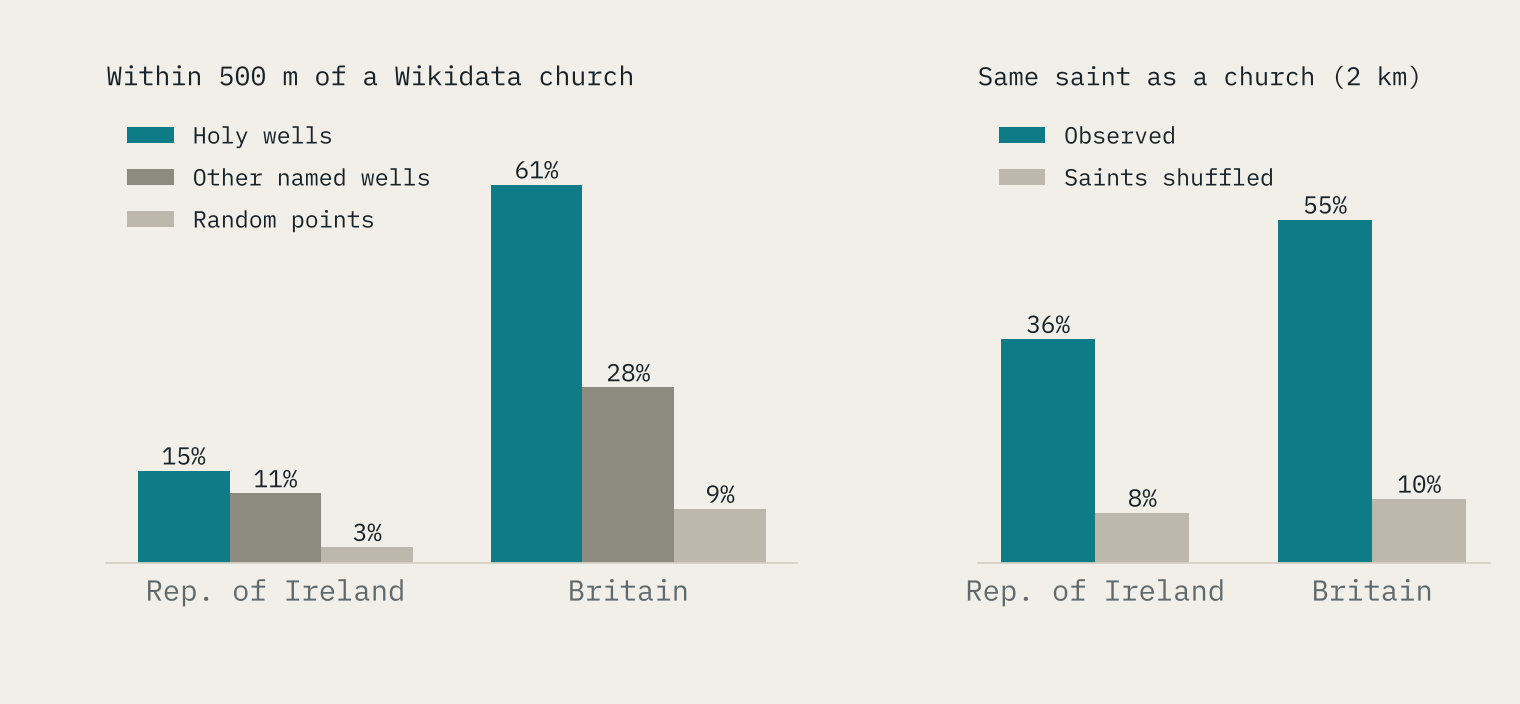
Holy wells sit close to churches, and often share their saint. In the Republic, 15% of holy wells are within 500 m of a church in Wikidata, against 3% of random points. Where a well and a church within 2 km both name a saint, they share it 36% of the time in the Republic and 55% in Britain, against about 8% to 10% by chance.
How I did this
The Irish wells are every record classed “ritual site, holy well” in the National Monuments Service’s Sites and Monuments Record. The rest are OpenStreetMap features that passed a step-by-step filter (well word as a word, no roads, buildings or businesses, tagged as a spring, well or religious feature), plus Wikidata holy wells, with anything within 150 m of an Irish inventory well treated as the same well. Saints are read only from plain forms in the names, and a few anglicised Irish forms only where the inventory’s own descriptions name the saint. Practices are word searches in the descriptions.
The big caveat is the one on the map: an official Irish survey against volunteer mapping in Britain. Scotland’s Canmore and Wales’s Coflein records would make the British picture much fuller, and I could not use them here. It is tempting to read the gap as the mark of the Reformation, but the same gap runs across the Irish border, so I do not.
Notes and sources
- Irish holy wells: National Monuments Service, Department of Housing, Local Government and Heritage, Sites and Monuments Record (Archaeological Survey of Ireland), CC BY 4.0. Quotations are from its descriptions.
- Wells in Britain, Northern Ireland and the Isle of Man: © OpenStreetMap contributors, ODbL.
- Holy wells and churches: Wikidata, CC0.
- Boundaries: Office for National Statistics (Open Government Licence v3) and Natural Earth (public domain).
- Companion: Whose Church Is It?, my earlier map of saints and holy wells across Western Europe.
- Paper, data and code: Zenodo and GitHub.
- I wrote the text, with drafting and editing assistance from Claude (Anthropic), which also helped prepare the analysis code. I reviewed and checked all text and results.

