
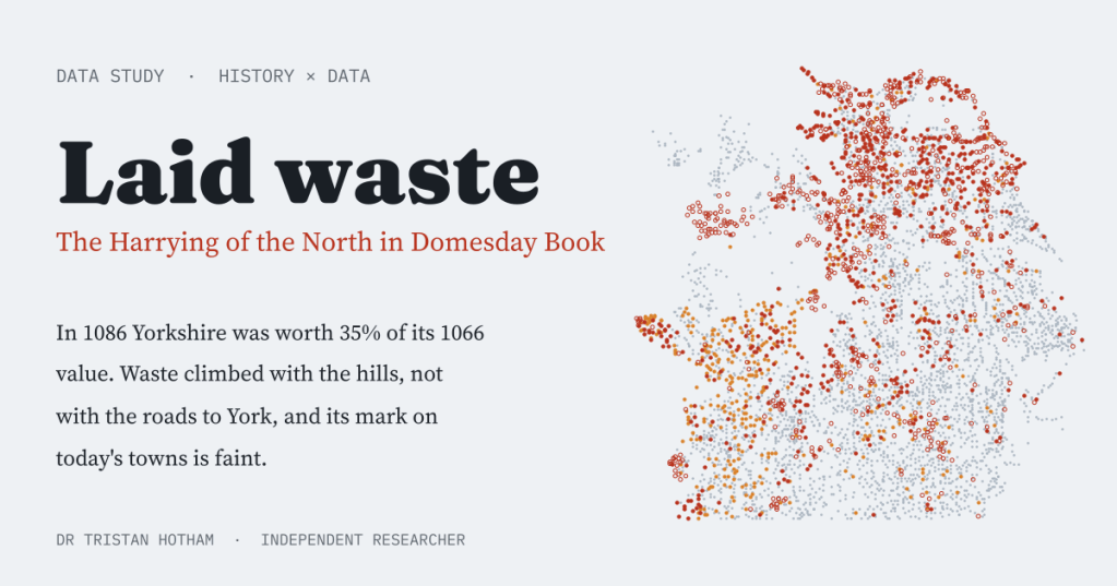
In the winter of 1069 to 1070 William the Conqueror laid waste the north of England. Sixteen years later Domesday Book wrote one word against hundreds of northern places: waste. I mapped every one, and went looking for the scar.
The Harrying of the North is the most notorious episode of the Norman Conquest. After a northern rising in 1069, William spent Christmas at York and his army destroyed crops, herds and stores across the region. Orderic Vitalis, writing about fifty years later, claimed that more than 100,000 people died in the famine that followed.
The best near-contemporary witness is Domesday Book. For most holdings it gives a value before 1066 and a value in 1086, and against many in the north it writes vastum, waste. I took the Hull Domesday Project’s coding of the whole survey, 20,195 entries, and followed that word: where it falls, what it means, whether it looks like the track of an army, and whether the places it touched are any different today.
A northern word
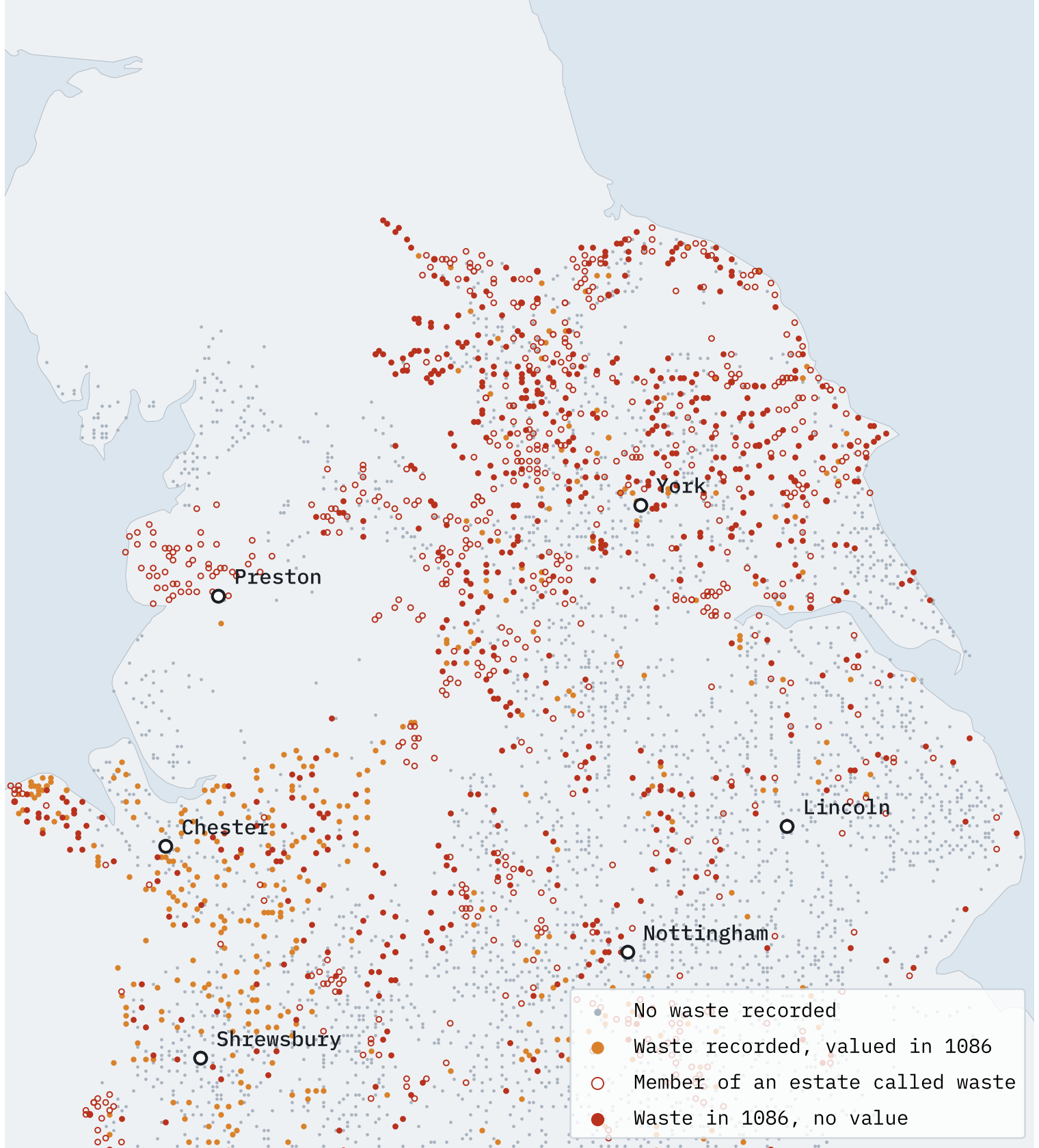
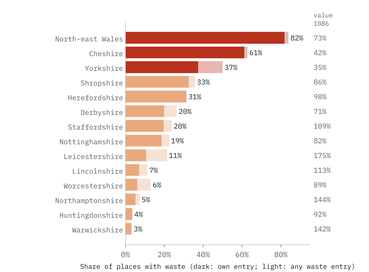
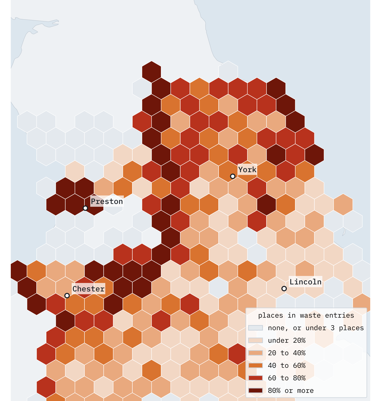
Waste is almost entirely a northern and border phenomenon. Of the 1,345 entries the Hull coders flag as waste, 79% are in six counties: Yorkshire, Cheshire, Derbyshire, Nottinghamshire, Staffordshire and Shropshire. Outside those and Herefordshire, only 2.1% of places have a waste entry, and the recorded value of those counties actually rose, to 110% of 1066.
In Yorkshire, 37% of the 1,302 places with an entry of their own are called waste, and half of all Yorkshire places are named in a waste entry once you count the member vills of great estates. Yorkshire’s recorded value in 1086 was 35% of what it had been in 1066.
One word, three meanings
Cheshire, harried in the same winter, has an even higher share of places touched by waste than Yorkshire: 61%. Yet its value fell less, and only 14% of its places were still waste with no value in 1086. The reason is in the wording.
For every county except Yorkshire, the data includes the English translation of each entry, so I sorted the waste entries by what they actually say. In Derbyshire, Nottinghamshire and Staffordshire, 95% say the land is waste, in 1086. In Cheshire and Shropshire, 70% say it was waste, usually when its new Norman lord received it around 1070, and most of those had a value again by 1086.
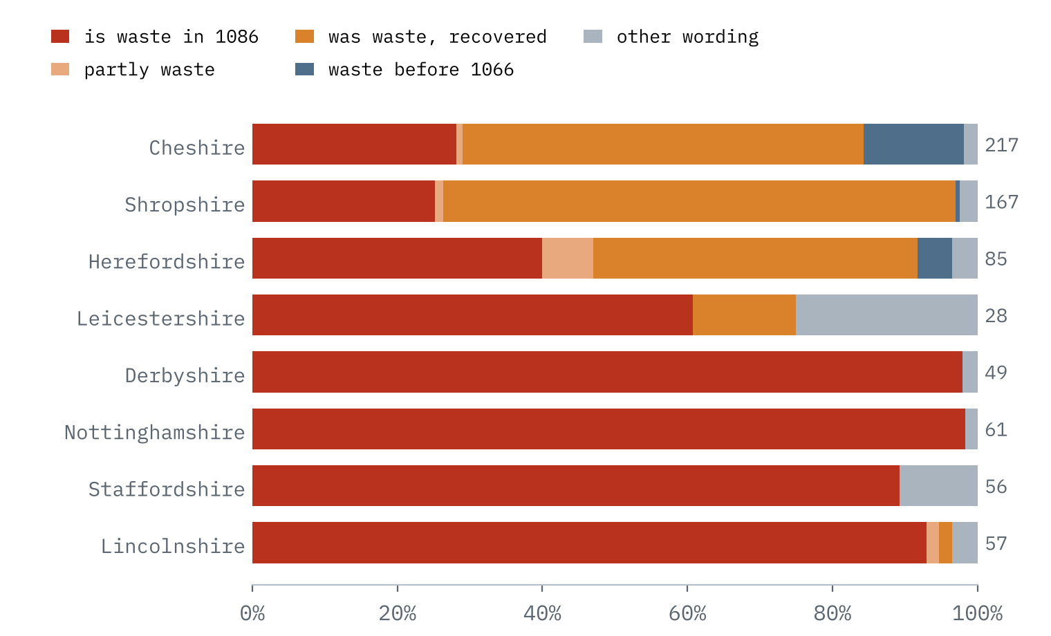
Yorkshire’s entries carry no text in the source, but its numbers speak: 83% of its 518 waste entries give no 1086 value at all. Elsewhere, waste entries with no 1086 value say the land is waste now in 80% of cases. So Yorkshire’s waste is mostly waste in 1086 itself.
Historians have long argued about what the clerks meant. The plain reading is destruction in 1069 to 1070. Others point to later Scottish raids, to new lords merging estates so that some holdings lost a value of their own, or to commissioners who simply could not put a value on a holding. I cannot settle that. What I can do is look at where the word falls.
Up the hills, not along the roads
If waste were the footprint of an army, you might expect it thickest around York, along the Roman roads and in the rich valleys. I measured each Yorkshire place’s distance from York, its height, and its distance to the nearest Roman road and named river.
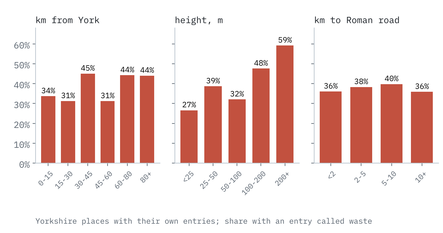
Distance from York makes no difference: the median waste place and the median place without waste are both 44 km from the city. Roman roads make none either. Height does. Below 25 m, 27% of places are waste; above 200 m, 59%. Taking everything together, each 100 m of height multiplies the odds of waste by 2.1.
The waste of 1086 is not a trail of burnt villages along the roads to York. It is a map of the hills and the margins.
That fits more than one story. An army living off the land would strip the valleys, but valleys also recover first, as survivors and new lords put the best land back to work. Marginal upland holdings might stay empty, or be folded into the manors that owned them. The money points the same way: rural places within 15 km of York were worth 65% of their 1066 value in 1086, against about a third further out. Sixteen years on, Domesday may be recording where recovery had not yet reached as much as where an army had been.
Can you still see the scar?
I matched every place to today’s built-up areas, parish populations and neighbourhood incomes, and compared the 323 places that were waste with no value in 1086 against 1,122 places with no waste, in the same county and of similar value in 1066.
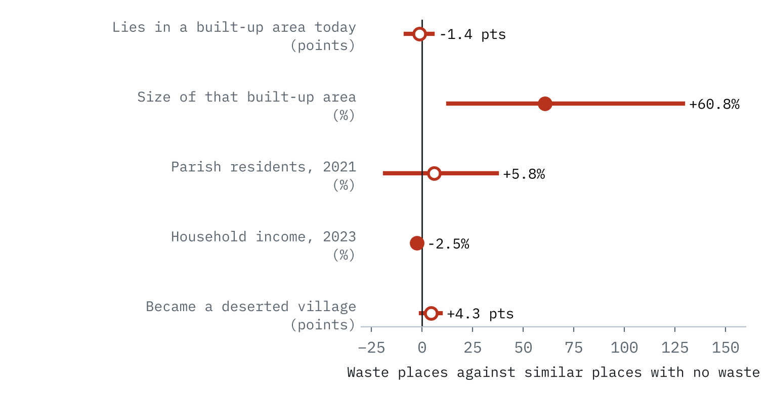
The scar is faint. Waste places are no less likely to be built up today, and their parishes are about as populous. Neighbourhood income is 2.5% lower, a gap small enough to have many other causes. And where waste places did become towns, they became big ones: Leeds and Bradford grew over land Domesday called waste, because the southern West Riding, heavily wasted in 1086, became the heart of the woollen industry. In Yorkshire, 15% of places named in waste entries later became deserted villages, against 14% of the rest: hardly different. Nine centuries of later history have largely written over 1069.
The Ribble valley
Lancashire did not exist in 1086. North of the Ribble, Amounderness is tacked onto Yorkshire; between the Ribble and the Mersey, south Lancashire is an appendix to Cheshire. Amounderness holds the most famous waste in the north-west. One entry names Preston and 61 vills belonging to it, and in John Porter’s 1876 translation says: “In sixteen of these vills there are but few inhabitants, but how many there are is not known. The rest are waste.”
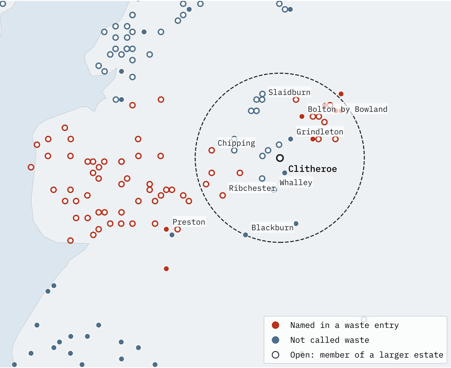
Clitheroe itself is not in Domesday Book. Within 15 km of it the survey names 38 places, 18 of them in waste entries, all in Craven (then Yorkshire) and Amounderness. Across the river, none of the places of Blackburn hundred, Whalley and Pendleton among them, is called waste. Instead the entry tells a quieter story: its new lords had settled men with eleven and a half ploughs and “granted exemption from dues for 3 years. It is therefore not now valued.” That is a landscape being restocked, not one being burned.
How I did this
Domesday entries and places come from the Hull Domesday Project’s coding via the realm-domesday repository. I used the manor and urban entries, leaving out Yorkshire’s summary sections, and treated a waste entry with no 1086 value as worth nothing in 1086. I sorted the wording of waste entries with simple word patterns. Height, relief and distances to rivers and Roman roads come from my earlier study of lost villages. Today’s measures are ONS Built-up Areas 2022, Census 2021 parish populations and ONS small-area income estimates for 2023, compared within county and 1066 value bands. These are associations, not proof of cause, and the Hull flag cannot tell “was waste” from “is waste” in Yorkshire. The interactive page and the paper set out every caveat.
This builds on three earlier studies: The Conquest in Castles, Is Domesday Destiny? and The Villages That Vanished.
Notes and sources
- Domesday data: Hull Domesday Project, Professor J.J.N. Palmer, George Slater and the University of Hull (CC BY-NC-SA), via realm-domesday.
- Lost villages: Beresford’s Lost Villages, University of Hull (CC BY-NC-SA 4.0).
- Office for National Statistics: Built-up Areas 2022, Census 2021 and income estimates for small areas, FYE 2023 (Open Government Licence v3.0). Contains OS data © Crown copyright and database right 2026.
- Roman roads: Itiner-e (CC BY 4.0). Rivers: OS Open Rivers (OGL v3). Elevation: AWS Terrain Tiles.
- Amounderness quotation: J. Porter (1876), History of the Fylde of Lancashire.
- On the debate: P. Dalton (2002) Conquest, Anarchy and Lordship; J. Palmer (1998) “War and Domesday waste”; H. M. Thomas (2008) The Norman Conquest; W. E. Wightman (1975) “The significance of waste in the Yorkshire Domesday”; and the Wikipedia article Harrying of the North for Orderic Vitalis.
- Paper, data and code: Zenodo and GitHub.
- I wrote the text, with drafting and editing assistance from Claude (Anthropic), which also helped prepare the analysis code. I reviewed and checked all text and results.

