
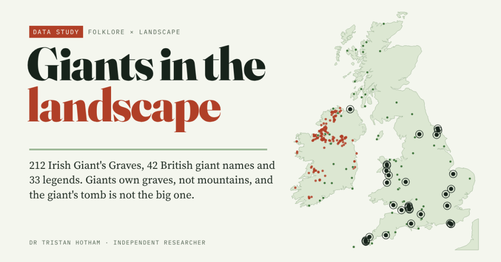
Giant’s Grave, Giant’s Chair, Giant’s Causeway, Giant Hill. Britain and Ireland are littered with giants’ belongings. I gathered 331 giant places, 212 Irish Giant’s Graves and 33 giant legends to ask an old question: did people explain big things with big people?
Giants have left their furniture everywhere. There is a Giant’s Chair on the Isles of Scilly and another in Argyll, a Giant’s Leg in Shetland and a Giant’s Thumb on the Conwy coast. On the chalk above Cerne Abbas a giant with a club has stood since, on recent dating, the tenth century. The stories are bigger still: Wade and his wife Bell hurling a hammer across the North York Moors, Cormoran building St Michael’s Mount, two giant brothers digging the Avon Gorge, Fionn mac Cumhaill laying a causeway to Scotland.
The usual explanation is simple. When people met something too big to account for, a great stone, a strange hill, a gorge, they said a giant made it. The Old English poem The Seafarer calls high stone walls the work of giants. If that is right, the places named for giants should be bigger, higher or more striking than ordinary places of the same kind. That is something the map can test.
Where the giants are
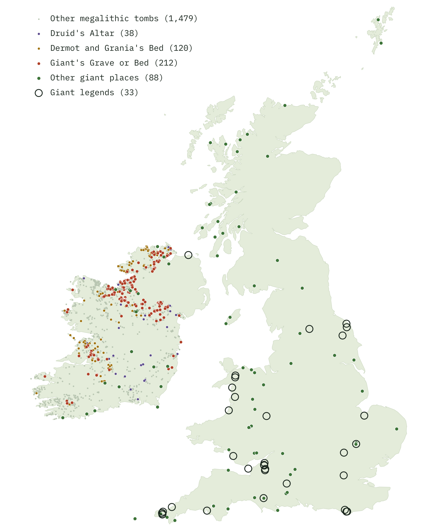
I used three kinds of evidence. Names: every place on the Ordnance Survey’s open gazetteer of Britain with Giant, the Gaelic famhair or the Welsh cawr in its name (42 of them), and giant features in OpenStreetMap for Ireland. Monuments: barrows, megaliths and hillforts whose recorded name has a giant in it, and every one of the 1,849 megalithic tombs in Ireland’s national Sites and Monuments Record, with the label the old Ordnance Survey maps gave it. Legends: 33 named giants whose stories a written source ties to a place.
The two islands look nothing alike. Of the 331 giant places, 264 are in the Republic of Ireland and 64 in Great Britain. Partly that is the sources: the Irish record kept the names the surveyors wrote on the maps, while Britain’s open gazetteer keeps few names of antiquities.
Giants own graves, not mountains
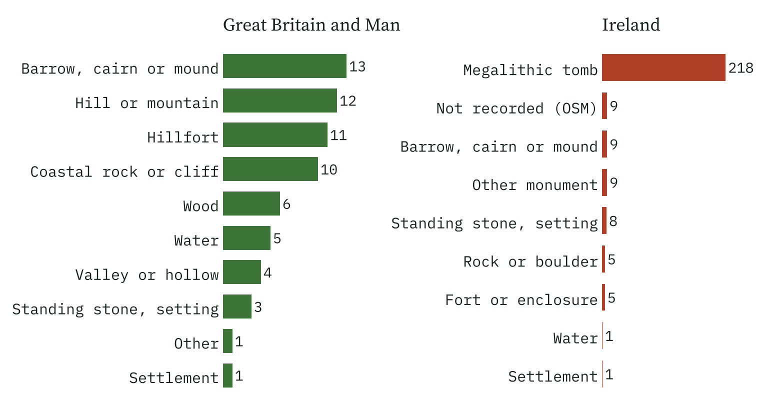
Sort the giant places by what they really are and a pattern jumps out. In Ireland 82% are megalithic tombs. In Britain the mix is wider, with hills, sea stacks, woods and lochs alongside barrows and hillforts. But the words people chose tell the same story everywhere: of 304 giant names in English, 261 call the place a grave or a bed. Then come stones and quoits, a few hills, a handful of chairs and seats, and odd body parts: a leg, a thumb, a rib. In the names, giants are mostly dead and buried.
Who gets the tomb?
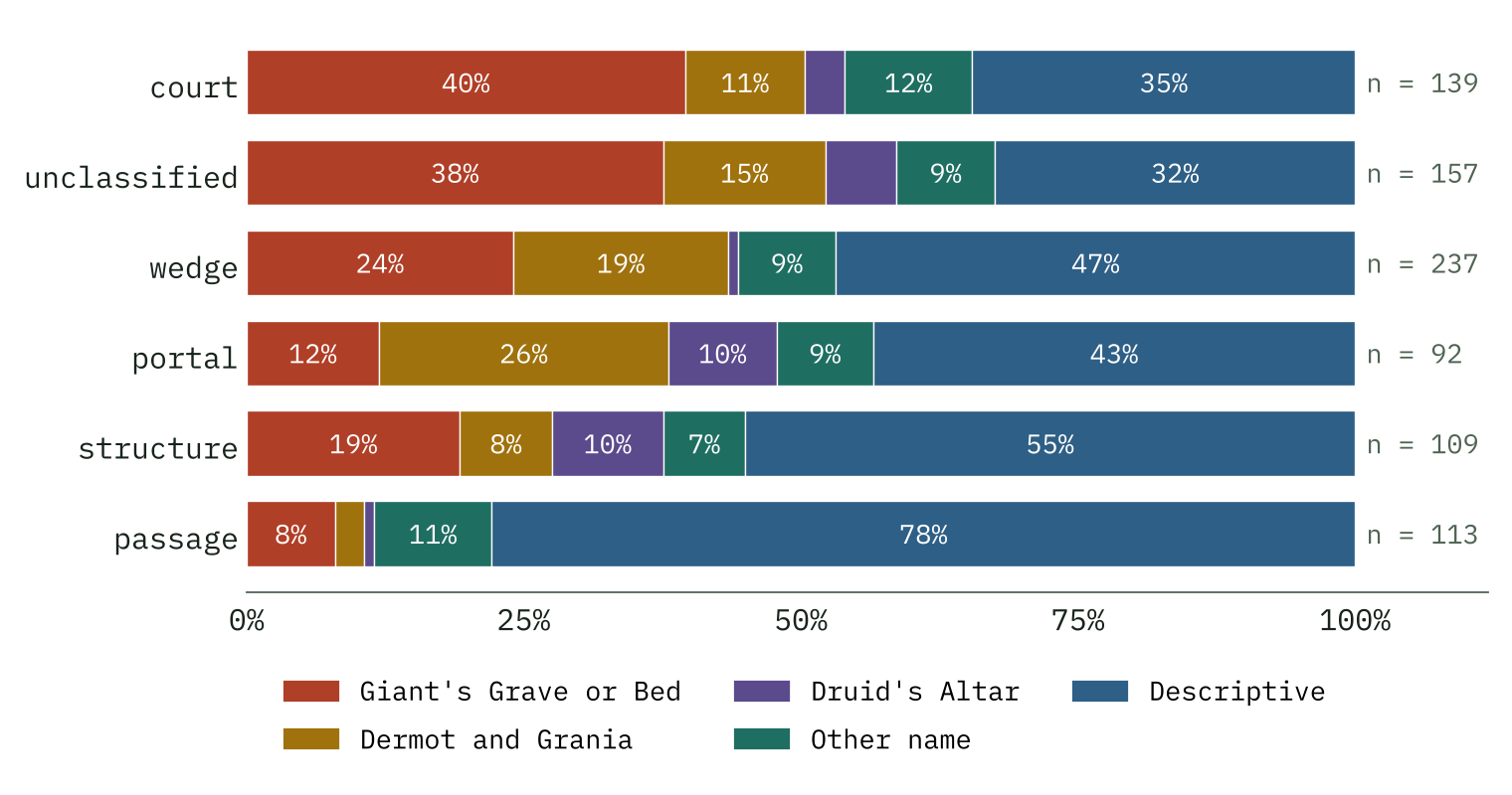
Ireland is the best test, because the tombs are all recorded and so are their map names. 212 tombs are Giant’s Graves or Beds, a quarter of all the tombs with a name. Another 120 are Dermot and Grania’s Beds, where folklore has the lovers of The Pursuit of Diarmuid and Gráinne camping as they fled, and 38 are Druid’s Altars.
Here is the first surprise. Giants take 18% of court tombs but only 4% of passage tombs, and passage tombs include the most famous prehistoric monuments in the country. On the maps the great hilltop cairns of Carrowkeel and Loughcrew are plain Carn, Knowth is a Moat and Newgrange a Tumulus. If giants were the go-to explanation for anything enormous, those would have been theirs.
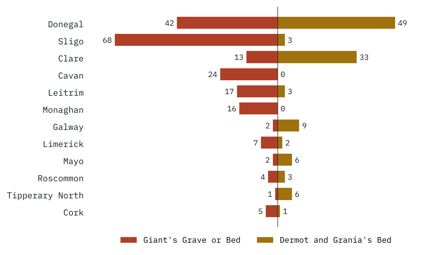
The second surprise is how regional the names are. 84% of Giant’s Graves lie in the northern part of Ireland, against 59% of all tombs. Sligo has 68, Cavan 24, Monaghan 16. Clare, with 233 tombs, has only 13 giants but 33 Dermot and Grania beds. The name a tomb got seems to depend on where it stood more than on what it was.
Is the giant’s tomb the big one?
No open record gives the size of an Irish tomb, so I measured what makes a monument look big as you walk past it: how high it sits above the ground around it. I compared every Giant’s Grave with fifty tombs of the same kind from the same 50 km square.
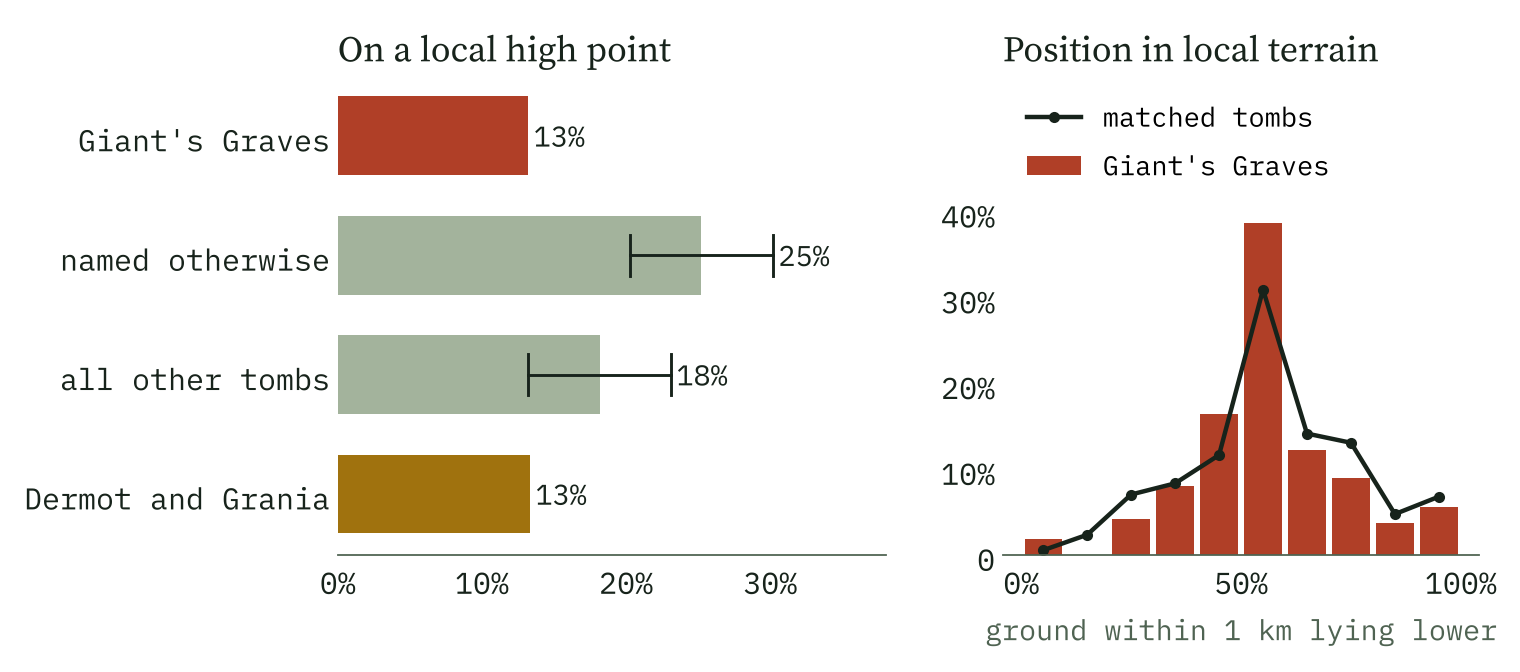
The Giant’s Graves are, if anything, the less striking tombs. 13% sit on a local high point, against 25% of other named tombs of the same kind nearby (chance below 0.001). The median Giant’s Grave stands 0.1 m above the ground around it; other named tombs, 3.9 m. The British giant monuments are too few to say much, but they point the same way: the giant hillforts enclose a median 1.16 hectares against 0.95 for comparable hillforts, a difference well within chance.
The name went to the tombs people lived beside, not to the ones that loomed over them.
What giant names really mark
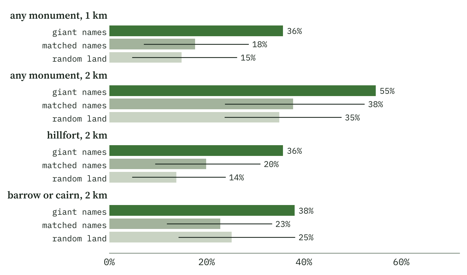
So if giant names are not about size, what are they about? In Britain, they are about age. I compared each giant name with fifty ordinary names of the same kind from the same area. 36% of giant names lie within 1 km of a recorded barrow, cairn, megalith, stone circle or hillfort, against 18% of the ordinary names (chance 0.001). Hillforts make the biggest difference. Sometimes the name is the monument: Giants Grave in Wiltshire is the hill that carries a hillfort of the same name.
And the giant hills are not giant. The thirteen hills named for giants stand a median 5.3 m above the ground 1 km around, against 22.7 m for ordinary hills nearby. The Cerne Abbas Giant is cut into a hill known as Giant Hill: the giant is on it, not in its size.
Where the stories do the heavy lifting
The legends are where the big-things idea comes alive. Of 33 placed stories, seven explain a natural landform: the Avon Gorge, Steep Holm and Flat Holm (the drowned Goram’s head and shoulder), St Michael’s Mount, Chapel Rock, Yr Wyddfa, the Giant’s Causeway. Five explain a prehistoric monument, from Stonehenge to the hillfort on Clifton Down, seven a Roman or medieval work such as Wade’s Causeway or Pickering Castle, and six are the chalk and turf giants themselves, of which only the Cerne Abbas Giant and the Long Man of Wilmington survive.
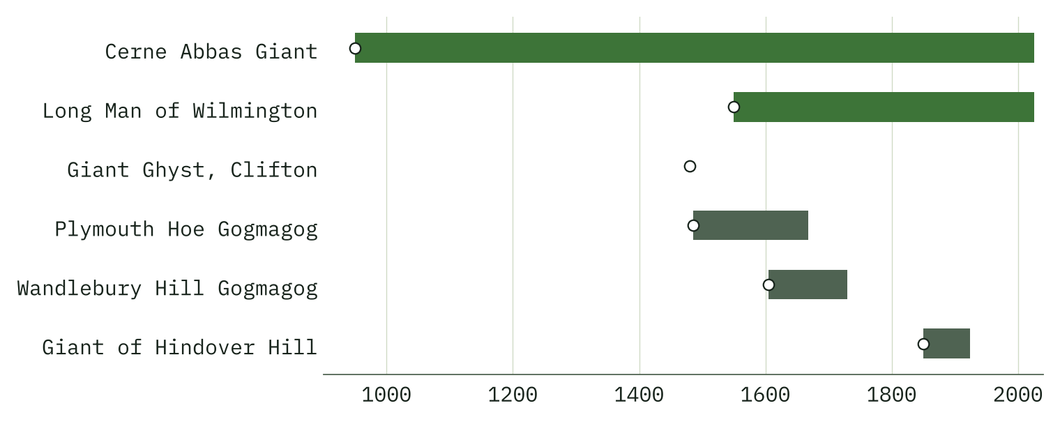
So the answer is split. The storytellers did reach for giants to explain gorges, islands and great works. But the names that stuck to the ground went mostly to graves: ordinary tombs, mostly in the north of Ireland, and the barrows, cairns and hillforts of the British past. Giants, it seems, were less the makers of big things than the people who came before.
How I did this
Names come from OS Open Names, matched on Giant, the Gaelic famhair and the Welsh cawr (Wade and Bran were left out because they are common words and surnames). Irish tombs and their map labels come from the National Monuments Service’s Sites and Monuments Record; 10,879 records with a placeholder position were dropped. British monuments come from OpenStreetMap, Wikidata and the Atlas of Hillforts. Prominence is measured from open terrain tiles with cells of about 95 m. Each giant place was compared with fifty places or monuments of the same kind from the same 50 km square, using 2,000 random draws.
The caveats matter. The Irish names are the surveyors’ record and may reflect local or surveyor habit. Britain’s open gazetteer has only 42 giant names. Terrain shows prominence, not the size of a monument. The legends come from a few written sources, and the legend places sit high partly because the stories put giants on hills. I ran many tests, so a single borderline result should be taken lightly.
Notes and sources
- Irish monuments: National Monuments Service, Department of Housing, Local Government and Heritage, Sites and Monuments Record, Archaeological Survey of Ireland, CC BY 4.0.
- Place names: OS Open Names. Contains OS data © Crown copyright and database right 2026, Open Government Licence v3.0.
- Monuments and Irish names: © OpenStreetMap contributors, ODbL, and Wikidata, CC0, via Is the Barrow a European Thing? and The Megalith Highway.
- Hillforts: Lock, G. and Ralston, I. (2017) Atlas of Hillforts of Britain and Ireland, CC BY-SA 4.0, as used in Within Sight.
- Legends and hill figures: English Wikipedia (CC BY-SA 4.0), including Hill figure, Goram and Vincent, Wade, Cormoran and The Pursuit of Diarmuid and Gráinne; English Heritage, A short history of giants and where to find them.
- Terrain: AWS Terrain Tiles (Mapzen/Tilezen). Coastlines: Natural Earth.
- The same matched-control method: Here Be Dragons.
- Paper, data and code: Zenodo and GitHub.
- I wrote the text, with drafting and editing assistance from Claude (Anthropic), which also helped prepare the analysis code. I reviewed and checked all text and results.

