
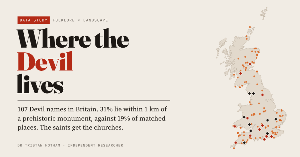
Devil’s Dyke, Devil’s Punch Bowl, Devil’s Arrows, Devil’s Bridge, Devil’s Kitchen. I put 107 Devil place names on the map of Britain to ask where the Devil lives, what he owns, and whether he really gets the old stones while the saints get the holy wells.
The Devil is the busiest landowner in British folklore. Above Brighton he dug Devil’s Dyke, a trench through the South Downs to let the sea drown the Christians of the Weald, until St Cuthman of Steyning fooled him with a candle and a crowing cock. At Boroughbridge he threw the Devil’s Arrows at the next town. On the Surrey heaths he leapt across the Devil’s Jumps until Thor threw a boulder at him. And all over the country he seems to have owned furniture: a chair, a kitchen, a frying pan, a pair of bellows.
It is often said that the Devil gets the strange old things in the landscape, the prehistoric stones and earthworks that nobody could explain, while the saints get the springs and the churches. That is a claim about geography, so I tested it.
Finding the Devil
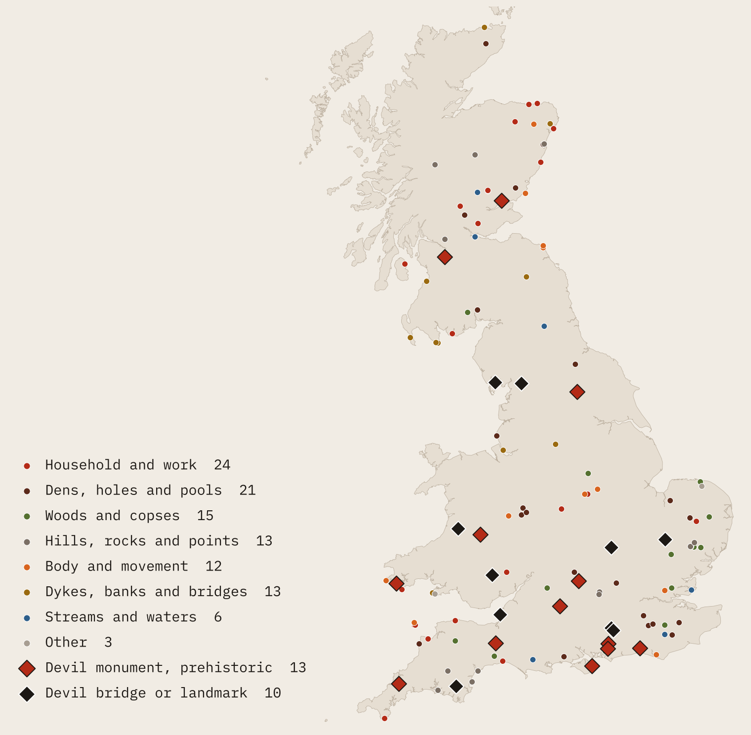
I searched every name on the Ordnance Survey’s open gazetteer and its open river network for the word Devil, the Scots Deil and the Gaelic words for the devil. That gives 107 places: 63 in England, 37 in Scotland and seven in Wales, from the Devil’s Point in the Cairngorms (in Gaelic, Bod an Deamhain) to the Devil’s Frying Pan in Cornwall. I set aside the Mandevilles and Devilla Forest, which only look devilish.
Oddly, the most famous Devils are missing from the gazetteer, which leaves out antiquities. So I also gathered 23 named Devil monuments and landmarks from other open records: barrows, standing stones, chambered tombs, a stone circle, a hillfort and seven Devil’s Bridges.
As a Christian counterpart I took 393 natural features named after a saint, such as St Peter’s Stone or St Catherine’s Hill, and focused on the 310 that do not simply borrow the name of a nearby St Something village. Then I compared every Devil and every saint name with fifty ordinary features of the same kind (woods with woods, coves with coves) from the same 50 km square, and with random land, using 2,000 replicate draws.
The Devil keeps house
Read the second half of each name and a household appears. The single commonest word is a den (10 of them), but the biggest group, 24 names or 22%, gives the Devil domestic property: a kitchen, a chair, a dining room, a dressing room, a study, a frying pan, a kettle, a caldron, an oven, a pair of bellows, a mill, a barn, a peat stack, a threshing floor, a bowling green and a punch bowl.
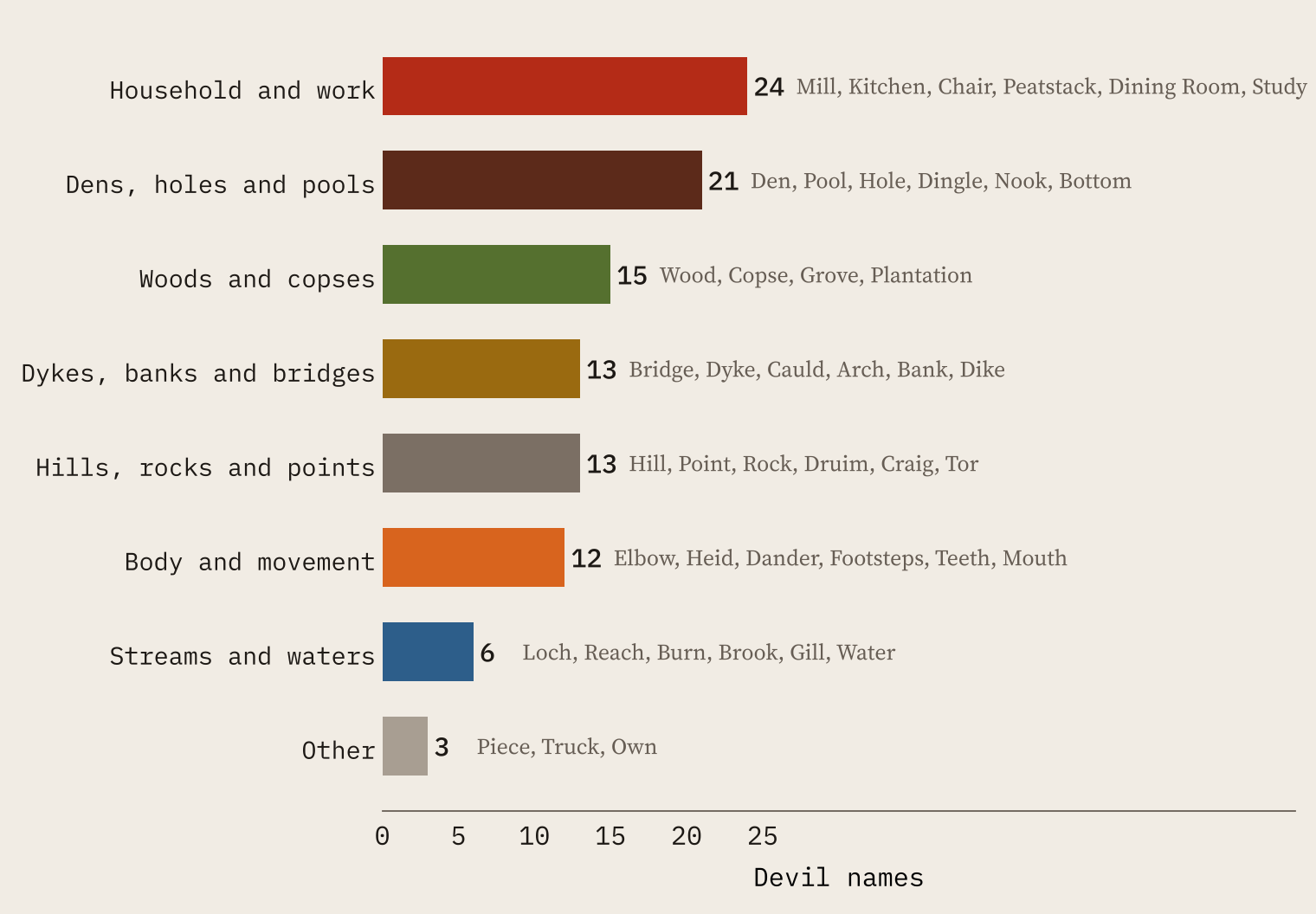
None of these are buildings. Twelve of the household names are coastal rocks, coves and beaches, from the Devil’s Kitchen in Devon to the Devil’s Dining Room in Aberdeenshire; most of the rest are waterfalls and pools, like the Deil’s Caldron in Perthshire. They read like explanations of shape: this hollow looks like a punch bowl, so whose punch bowl is it?
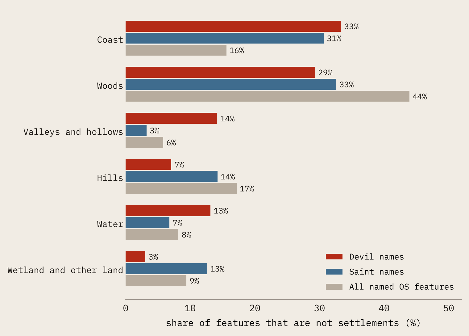
Compared with the gazetteer as a whole, the Devil is drawn to holes and the coast: valleys and hollows make up 2.4 times as large a share of his names as of all names, coastal features 2.1 times. Saints like the coast too, where islands and bays carry their names, but they keep out of the hollows.
The Devil gets the old stones
Now the main test. 31% of Devil names lie within 1 km of a recorded prehistoric monument (a barrow, a standing stone, a stone circle or a hillfort). Of the matched ordinary places, 19% do, and of random land 13%. In 2,000 replicate draws of matched places, a gap that large did not turn up once.
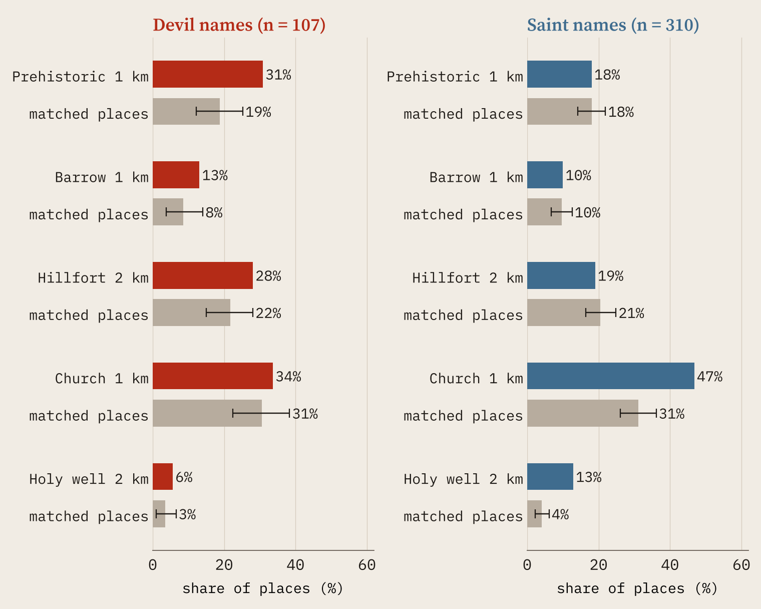
The saints show nothing of the kind: 18% of their names lie that close to a prehistoric monument, exactly like their matched places. Instead they sit by the church (47% within 1 km, against 31%) and the holy well (13% within 2 km, against 4%). The Devil’s names are no nearer churches than anywhere else.
The Devil sits next to the barrows and the hillforts; the saints sit next to the church and the well.
Some cases are almost too neat. In Deils Wood in East Renfrewshire there is a recorded cairn 4 m from the map point. Devil’s Tor on Dartmoor stands 36 m from the Beardown Man standing stone. On the Aberdeenshire coast the Devil’s Dining Room, the Deil’s Kettle and the Devil’s Peatstack each sit beside a coastal fort. And Devil’s Dyke above Brighton lies right below its hillfort.
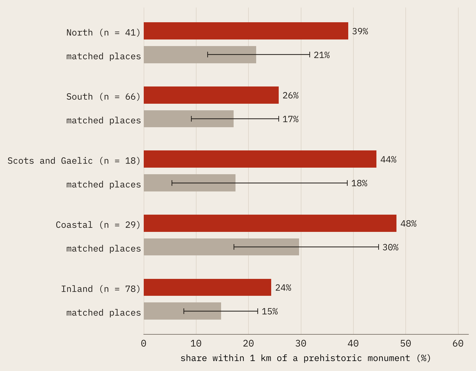
The pattern is strongest in the north (39% against 21%) and among the Scots Deils (44% against 18%). Coastal Devils lean on coastal forts. But it holds inland too (24% against 15%), and in the south the barrows carry it.
Steep ground, but no edges
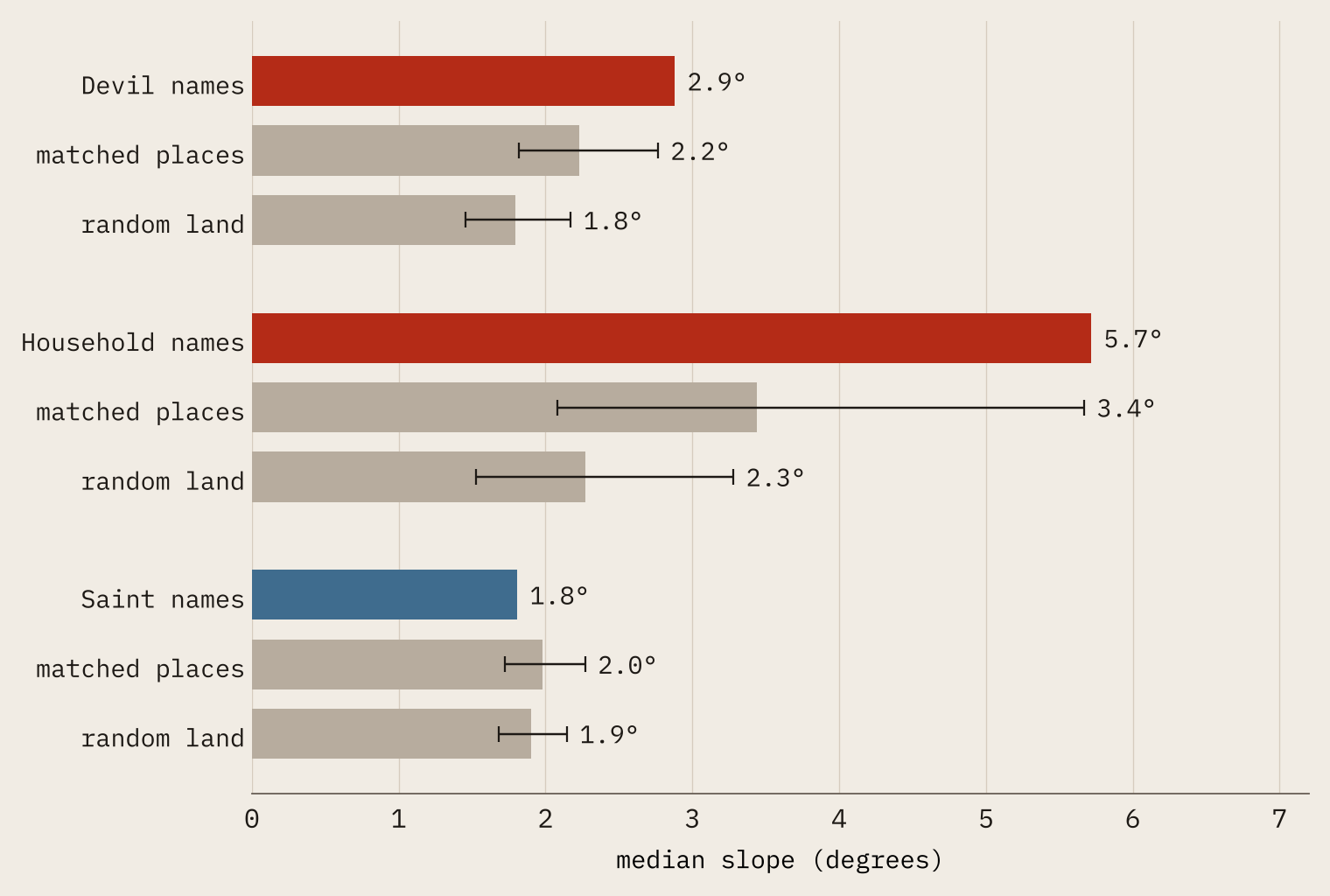
Is the Devil’s ground odd ground? A little. The median slope at a Devil name is 2.9 degrees, against 2.2 for matched places and 1.8 for random land, and the household names are steepest of all. But the overall relief around them is no greater than around matched places: the drama comes with the kind of feature, coves and gorges, rather than from the Devil picking the wildest examples. Saint names sit on slightly gentler, lower ground.
Devils are sometimes said to haunt boundaries. I could only test county boundaries, not parishes, and there is nothing there: 11% of Devil names lie within 2 km of one, against 13% of matched places.
Old stones, new names
Here is the catch. A Devil name records a story, not a date. Of the 23 famous Devil monuments, 13 are prehistoric. But where Wikipedia dates the name, it is late: John Aubrey mentions the Devil’s Arrows in 1687, though the stones are Stone Age; the English name Devil’s Bridge is first recorded in 1734; the Devil’s Jumps first appear on a map of 1765. The great Devil’s Dyke near Newmarket was simply “the ditch” in medieval documents. So the map does not show the Devil moving in when the barrows were built. It shows where people, much later, looked at something ancient and strange and decided only the Devil could have made it.
How I did this
Names come from OS Open Names and OS Open Rivers: Devil as a word (with ‘s, s or s’), Devils- joined to a following word, the Scots Deil and the Gaelic Deamhain or Diabhail. Saint names are features that are not settlements with St or Saint in their name. Prehistoric monuments are 12,387 barrows and cairns, 1,194 megaliths and stone circles from OpenStreetMap and Wikidata, and 3,610 hillforts from the Atlas of Hillforts; churches are 36,435 Wikidata church buildings and holy wells 367 records from my holy wells study. Slope and relief come from an open elevation model with cells of about 100 m.
The caveats matter. There are only 107 Devil names, so the word groups are small. The gazetteer leaves out antiquities, so the famous monument Devils are described, not tested. Monument records are patchy, and holy wells in Britain are thinly recorded. Coastal forts drive much of the coastal result. Many names may be recent. And I ran 15 measures on several groups, so a single borderline result should be taken lightly. The two I would stand behind are the Devil’s closeness to prehistoric monuments and the saints’ closeness to churches and holy wells.
Notes and sources
- Place names and rivers: OS Open Names and OS Open Rivers. Contains OS data © Crown copyright and database right 2026, Open Government Licence v3.0.
- Barrows, megaliths, stone circles and holy wells: © OpenStreetMap contributors, ODbL, and Wikidata, CC0, via Is the Barrow a European Thing?, The Megalith Highway, Same Shape, Different Millennia and From Saint to Wish.
- Hillforts: Lock, G. and Ralston, I. (2017) Atlas of Hillforts of Britain and Ireland, CC BY-SA 4.0.
- Churches and bridges: Wikidata, CC0, with churches as compiled in Whose Church Is It?
- Legends and dates: English Wikipedia articles Devil’s Dyke, Sussex, Devil’s Arrows, Devil’s Bridge, Ceredigion, Devil’s Jumps, Churt and Devil’s Dyke, Cambridgeshire (CC BY-SA 4.0).
- Terrain: AWS Terrain Tiles. County boundaries: Office for National Statistics, OGL v3.0.
- The same matched-name method: Here Be Dragons.
- Paper, data and code: Zenodo and GitHub.
- I wrote the text, with drafting and editing assistance from Claude (Anthropic), which also helped prepare the analysis code. I reviewed and checked all text and results.

