
When the Armada was sighted off the Lizard in 1588, fire carried the warning from hill to hill. Hundreds of years later, 193 hills still carry the word “beacon” in their name. I lit a fire at the Lizard and traced where it could go.
On 19 July 1588, by the English calendar of the day, the Spanish Armada was sighted off the Lizard in Cornwall, and a chain of beacons was lit to spread the warning. In 1832 Macaulay made it a poem, “The Armada”, with fire running across England through the night until “twelve fair counties saw the blaze on Malvern’s lonely height”.
I wanted to know whether that picture holds up on the ground. How fast could fire really carry the news? The beacons have left a clue: all over England there are hills called Beacon Hill, or Something Beacon. If each of them held a fire, and each fire could only be answered by someone who could see it, how far would the warning get, and how quickly?
193 hills called beacon
I took every hill and summit in the Ordnance Survey’s open gazetteer with “beacon” in its name, added two named historic beacons from OpenStreetMap, and threw out woods, farms, reservoirs and sea marks. That left 193 sites: 180 in England, 7 in Wales and 6 in Scotland. 118 of them are plain Beacon Hill. Welsh and Scottish hills mostly have names in their own languages, so this is really a map of England.
Then I traced a line of sight between every pair, using the same code as my study of hillforts, Within Sight: from a watcher’s eye 2 m above one hill to the top of a fire 5 m above another, over a model of the ground, allowing for the curve of the earth. I allowed sight lines of up to 50 km, because a fire at night carries a long way.
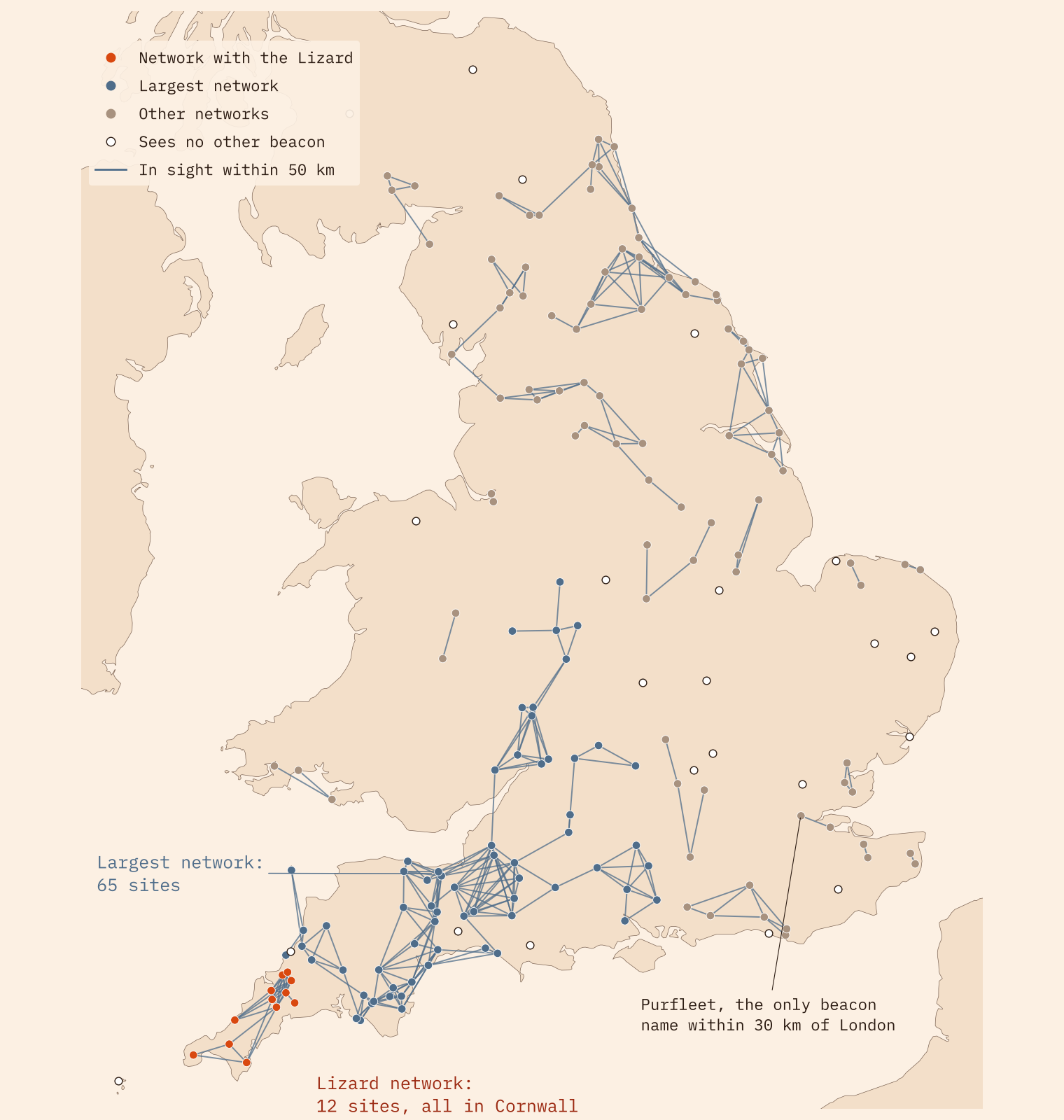
Most beacon hills can see another. Within 50 km, 165 of them (85%) have at least one other beacon’s fire in view. But they do not join up into one network. They form 44 separate ones.
A fire that never leaves Cornwall
The largest network has 65 hills, from east Cornwall and Dartmoor through Somerset, Dorset and Wiltshire and up to the Malverns. But the Lizard is not in it. The beacons near the Lizard form their own little network of 12 hills. Light Roskruge Beacon, the beacon hill nearest the Lizard, and the fire reaches all 12 within 3 hops, and stops.
The nearest way out of Cornwall would need a 53.2 km sight line, from a hill called The Beacon in mid Cornwall to Penn Beacon on Dartmoor. London is worse. The only beacon-named hill within 30 km of London is Beacon Hill at Purfleet, 13 m above sea level, and from it no other beacon fire is in sight at any distance I tried, up to 150 km. York and Berwick have no beacon-named hill within 30 km at all.
The names alone do not make a chain. They are what is left of one.
That is not evidence that there was no chain. Plenty of real beacons stood on hills whose names never mention them, and some Beacon Hills may be named for later fires. A beacon name is evidence that someone lit, or planned to light, a fire there at some time. It is not proof of 1588.
Filling the gaps
So I asked how close the names come. I added a possible relay fire on the highest ground of every 10 km square of the National Grid, 2,665 of them, standing in for the beacons, watch points and towers that left no “beacon” in the gazetteer. Then I lit the Lizard again.
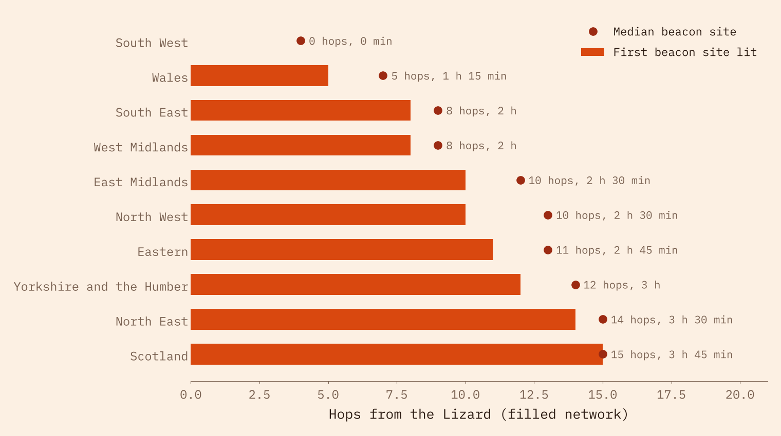
This time the fire reaches 191 of the 193 beacon hills. It gets to the edge of London in 9 hops, to Malvern in 8, to Beacon Fell above Preston in 11, to York in 12 and to the border near Berwick in 16.
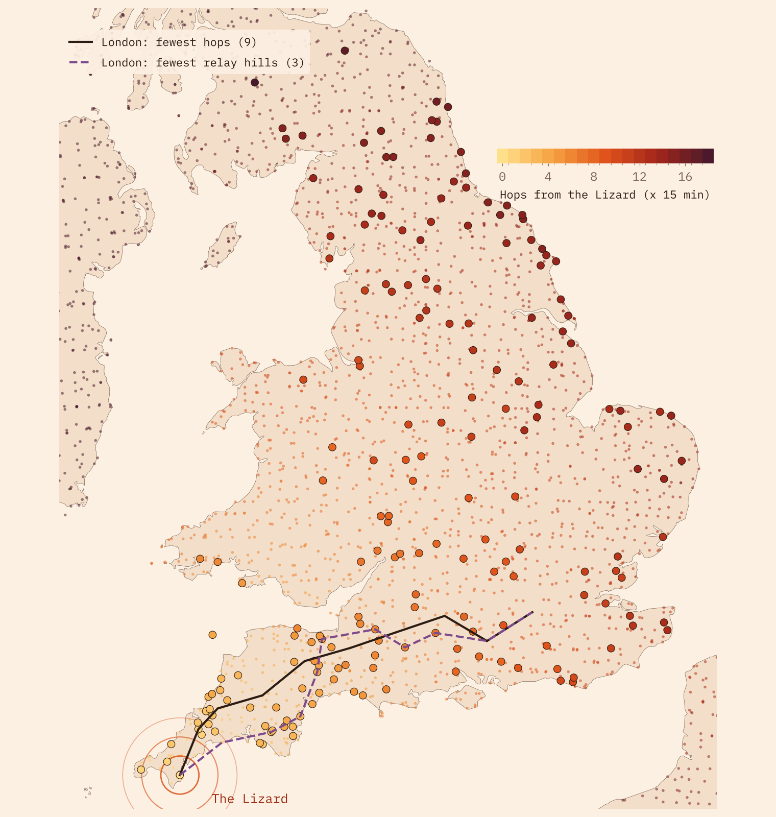
Better still, the gaps are few. The quickest route to London runs mostly over relay hills, because they are everywhere. But if I ask for the route that needs the fewest of them, the answer is just three: one to get the fire out of Cornwall near Polperro, and two in Hampshire and Surrey. Everything in between is a named beacon, on Dartmoor, the Blackdown Hills, in Somerset and in Wiltshire. Malvern needs only one.
How long is a hop?
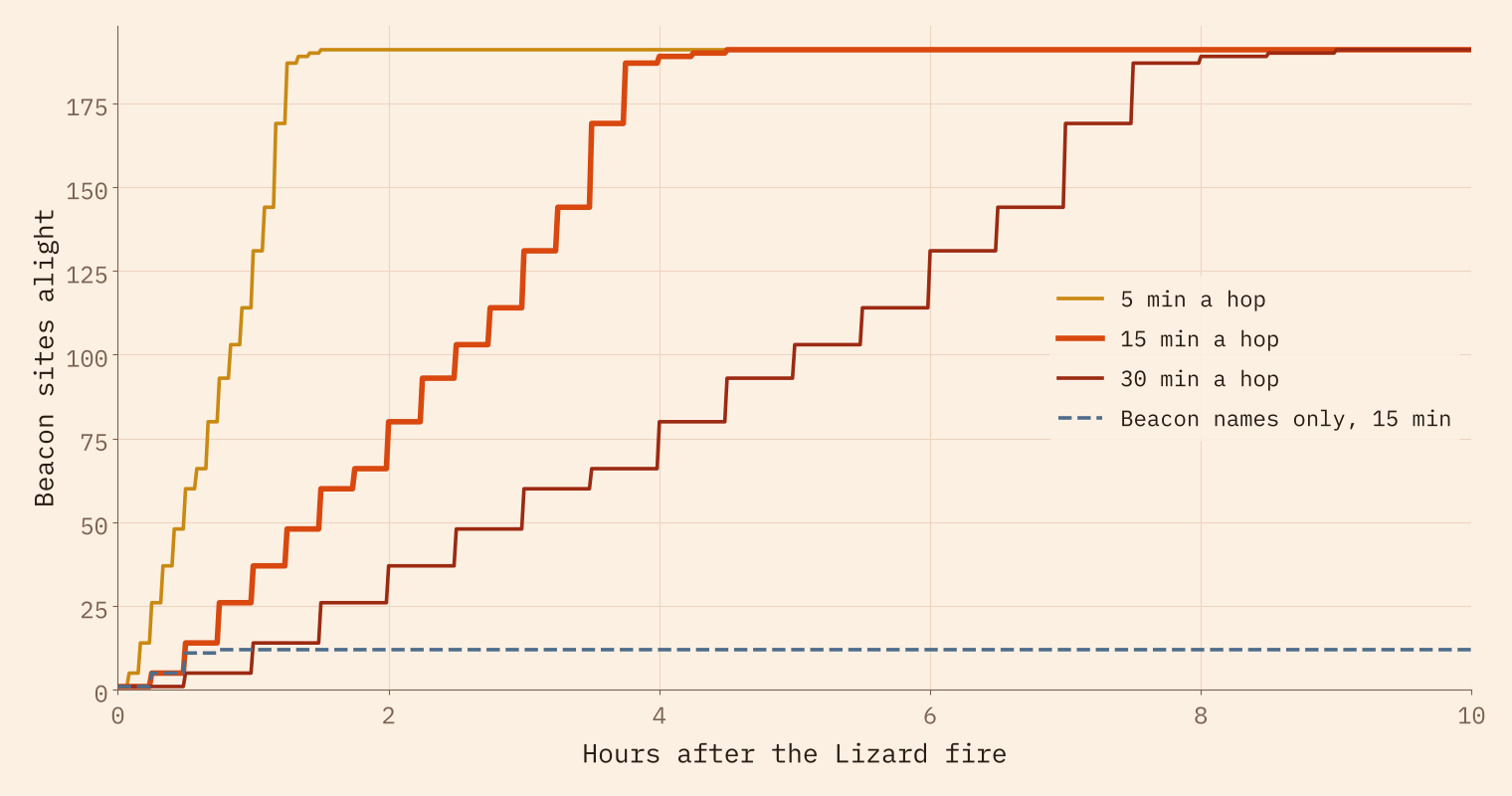
Here I have to be honest: nobody timed the beacons, and I found no reliable figure for how long one took to answer another. So I show a range. Five minutes a hop is an alert watcher with dry fuel ready. Fifteen is a middle case. Thirty allows for noticing the glow, making sure it is a beacon and not a burning barn, and getting a big fire going.
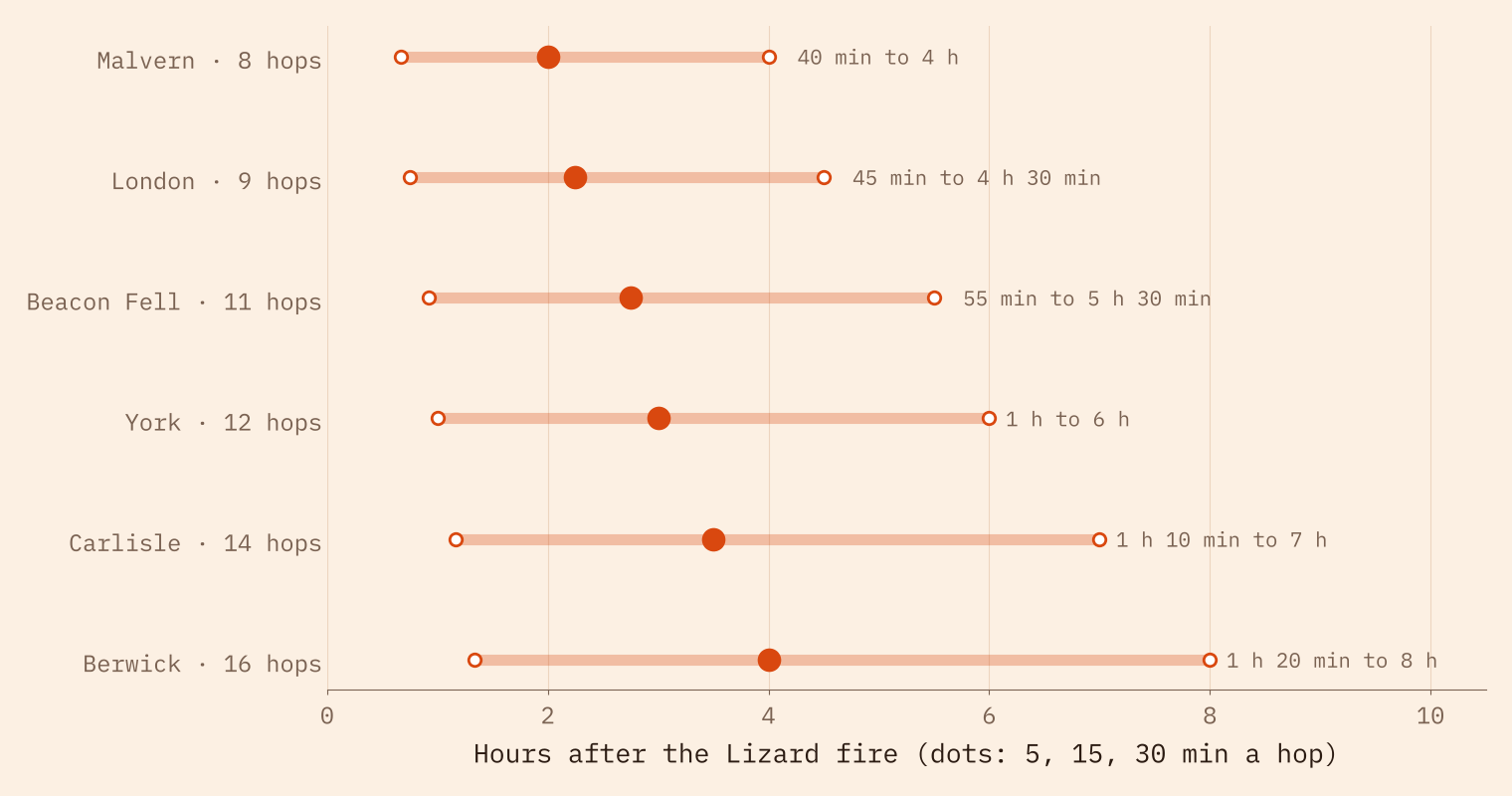
On those terms the news reaches the edge of London in 45 minutes, 2 hours 15 minutes or 4 hours 30 minutes. York takes 1 hour to 6 hours, and the Scottish border 1 hour 20 minutes to 8 hours.
At fifteen minutes a hop, 80 beacon hills are burning after two hours and 189 after four. The last one is lit after 18 hops. On the names alone, the count never rises above 12.
Where one fire matters most
Some beacon hills matter far more than others. The one that sits on the most shortest routes between other beacons is Beacon Batch, the top of Black Down, the highest hill in the Mendips, a range Macaulay names in his poem. Leave it unlit and 12 hills drop out of the largest network. There are 11 hills like that in the largest network: lose any one and it splits.
How I did this
The beacon hills come from OS Open Names, with two named historic beacons from OpenStreetMap. Each point is moved to the highest ground within 250 m. The ground is the AWS Terrain Tiles elevation model, with pixels about 90 m across, sampled every 45 m along each line, with the curve of the earth and standard refraction. A fire passes from one hill to another when its fire can be seen from the other. I also ran everything with 30, 70 and 100 km sight lines, a 10 m fire, and the original name points; the names never reach London in any of them.
The limits matter. A line of sight is not the same as seeing a fire through haze or rain. The elevation model smooths summits and has no trees. The relay hills are a model, not lost beacons. And the time per hop is my assumption: the hop counts are the solid result.
Notes and sources
- Place names: Ordnance Survey, OS Open Names. Contains OS data © Crown copyright and database right 2026 (Open Government Licence v3.0).
- Two beacon sites: © OpenStreetMap contributors (ODbL).
- Elevation: AWS Terrain Tiles by Mapzen/Tilezen, from sources including SRTM, GMTED2010 and ETOPO1.
- Sighting date: Royal Museums Greenwich, Elizabeth I and the Spanish Armada. The poem: Wikipedia, Lays of Ancient Rome and Worcestershire Beacon. Beacon Batch: Wikipedia, Black Down, Somerset.
- Paper, data and code: Zenodo and GitHub. Companion study: Within Sight.
- I wrote the text, with drafting and editing assistance from Claude (Anthropic), which also helped prepare the analysis code. I reviewed and checked all text and results.

