
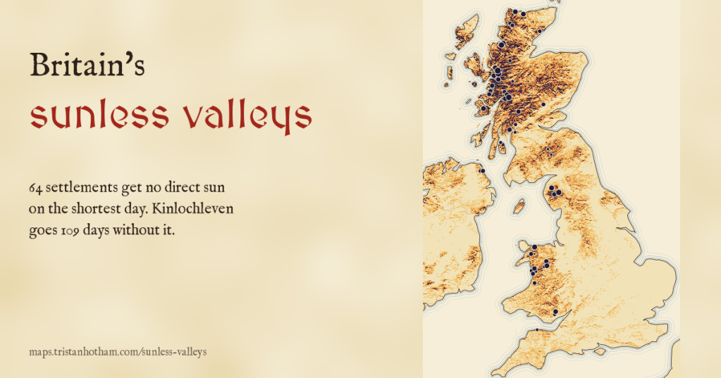
On the shortest day the sun barely clears the horizon in Britain, and hills hide it. I worked out the skyline of every town, village and hamlet in the United Kingdom and drew the winter sun across it. 64 places get no direct sun at all on 21 December, and in the Highlands some go more than three months without it.
Rjukan in Norway famously sits so deep in its valley that it put mirrors on the mountainside to bounce winter sunshine into the town square. Britain’s hills are much lower than Norway’s, so it is easy to assume nothing like that happens here. But Britain is also far north. On 21 December the noon sun climbs only 16.6 degrees above the horizon on the south coast of England, 10.6 degrees in the Central Belt of Scotland and 6.6 degrees in Shetland, and for the rest of its short day it is lower still, skimming round from the south east to the south west. A hill a few hundred metres high, a couple of kilometres to your south, is enough to hide it.
So which places really go without sunshine in midwinter, and for how long? I took the open terrain model that covers Britain and Ireland at about 90 metres, worked out the skyline from 36,692 towns, villages and hamlets, and from every 175 metre square of land, and drew the path of the winter sun across each one.
A little lost almost everywhere
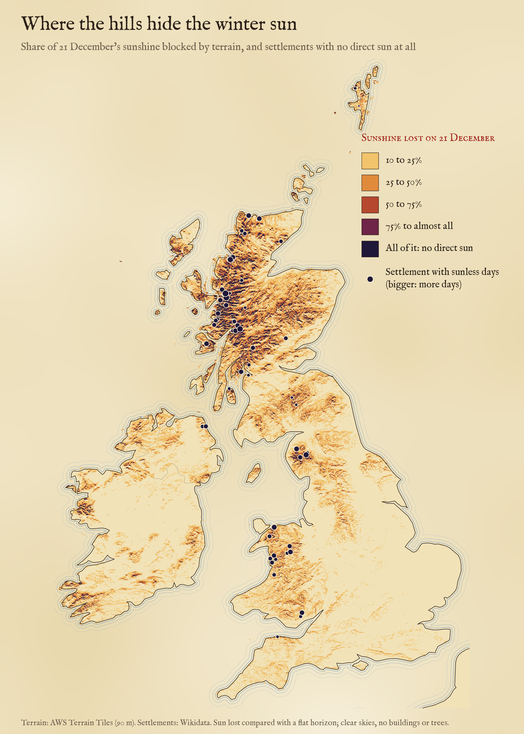
With a flat horizon the shortest day lasts 8 h 01 min in the Isles of Scilly and 5 h 28 min at the top of Shetland. Hills take something from almost everyone: the median settlement loses 18 minutes, mostly the very first and last light when the sun is a degree or two up. But 5,031 places, 14% of them, lose at least an hour, and 331 lose half their sunshine or more. The median settlement in Scotland loses 41 minutes, the median in Wales 41, and the median in England 14.
And 64 places get none at all: 41 in Scotland, 15 in Wales, 6 in England and 2 in Northern Ireland.
Kinlochleven, Seldom Seen and the dark glens
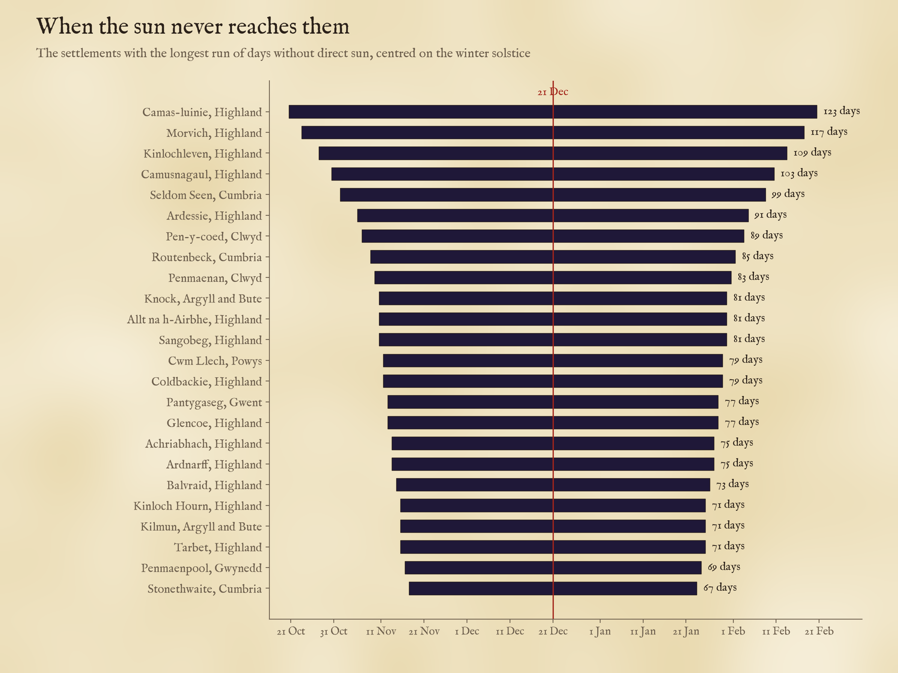
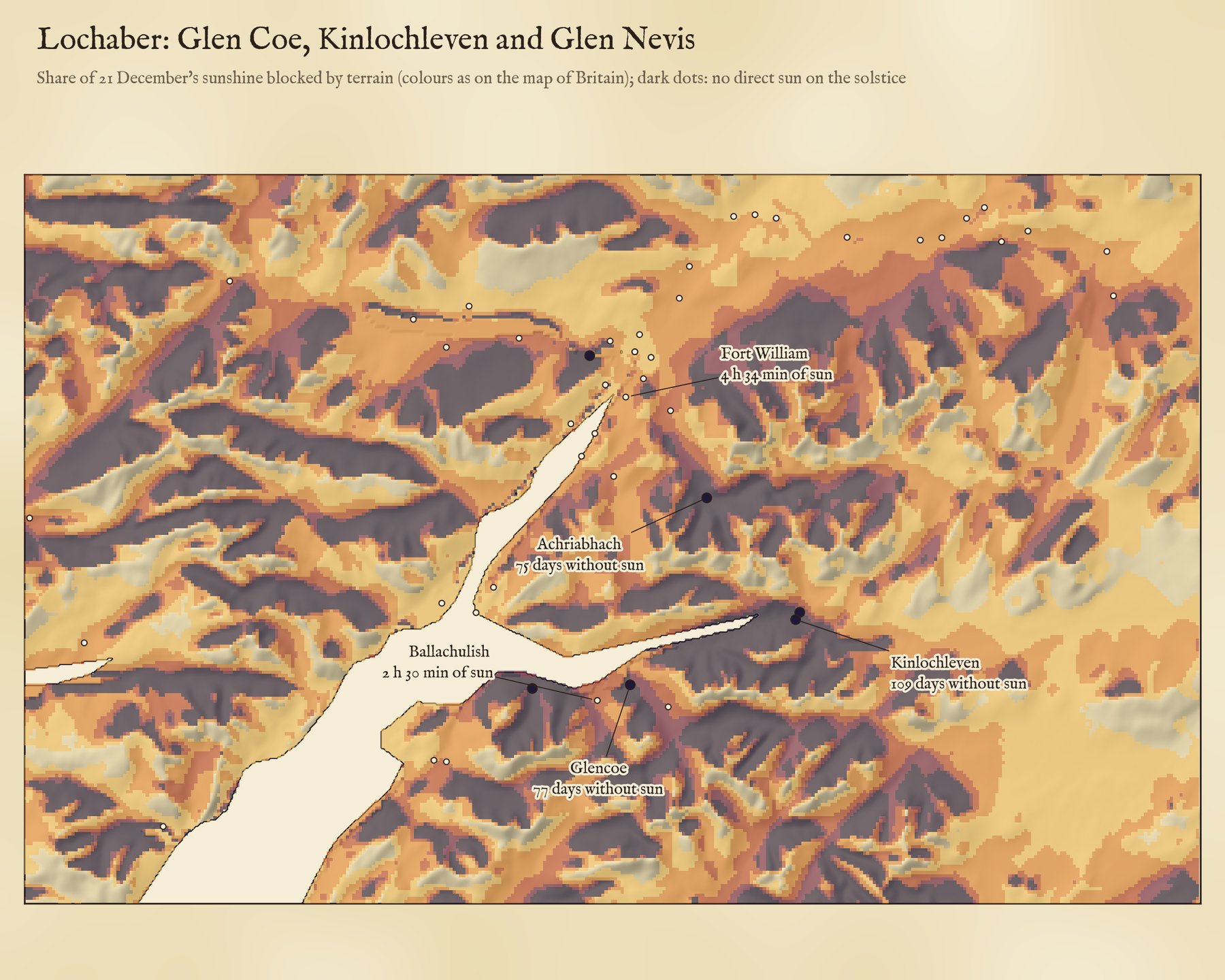
The longest runs without direct sun are in the western Highlands, in valleys that run east to west under a steep southern wall. Camas-luinie in Kintail tops the list at 123 days, from about 21 October to 20 February. The largest of them all is Kinlochleven, a village of about 810 people at the head of Loch Leven with the slopes of Garbh Bheinn rising straight up to its south. Seen from the village, the skyline due south stands 25.6 degrees high. The sun at noon on the solstice reaches 9.9. On this computation it stays hidden for 109 days, from about 28 October to 13 February.
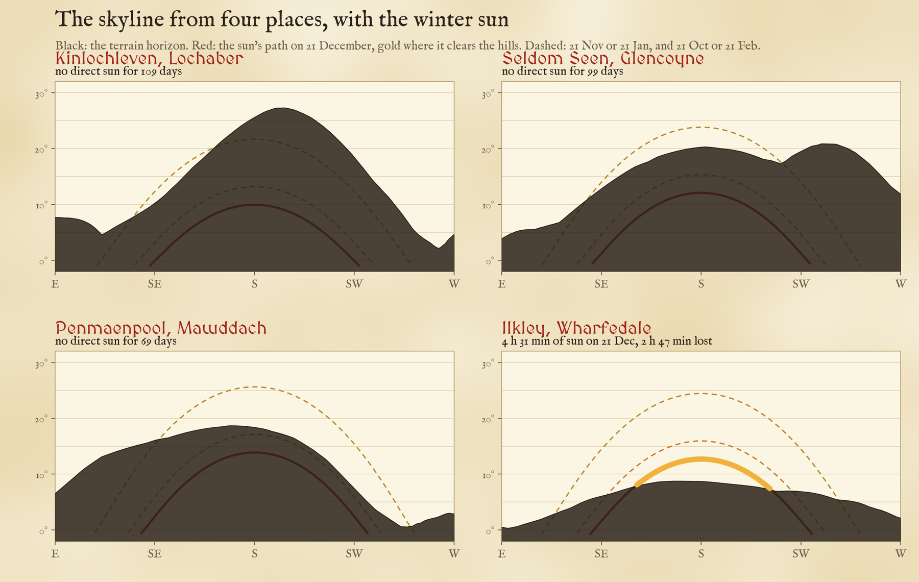
My favourite find is in the Lake District. In Glencoyne, the side valley next to Glenridding above Ullswater, there is a row of old miners’ cottages called Seldom Seen, and it earns its name: no direct sun for 99 days. In Borrowdale, Stonethwaite goes 67 days, and Glencoe village, at the foot of the glen, 77.
At Kinlochleven the skyline due south stands 26 degrees high. The midwinter sun reaches 10.
Towns in the shade
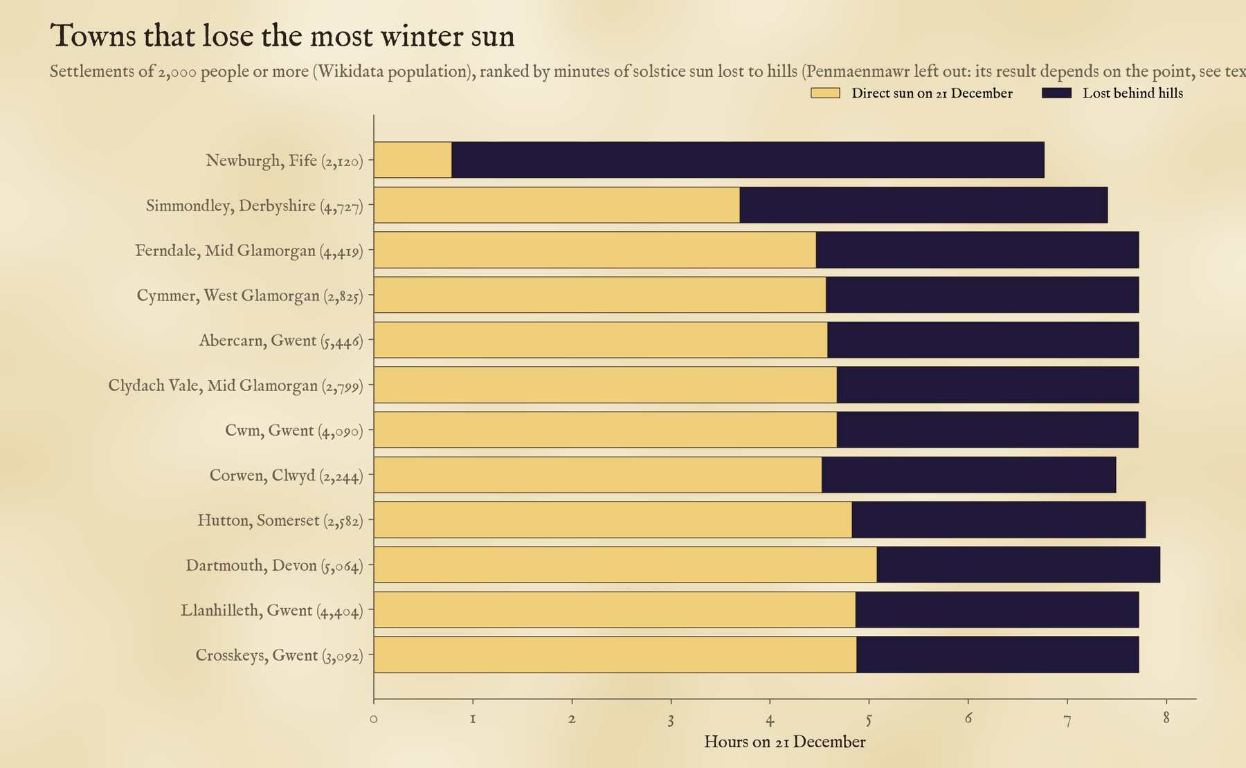
Most of the sunless places are hamlets of a few houses. One town nearly made the list. Penmaenmawr on the North Wales coast, home to about 4,353 people, sits under steep hills east of the headland it is named after. From its Wikidata point, west of the town centre, the sun stays behind the hills all day on the solstice; from the town’s point on OpenStreetMap, half a kilometre east, it shows for 1 h 39 min. So part of the town is in shadow, not all of it, and I have not counted it. Newburgh in Fife, tucked under the hills on the south shore of the Tay, keeps just 47 min of sun. After them come the South Wales valleys: Ferndale in the Rhondda keeps 4 h 28 min of a 7 h 43 min day. Of the bigger towns, Ilkley in Wharfedale, with Ilkley Moor to its south, loses the most: 2 h 47 min.
Away from where people live, 4,956 square kilometres of the United Kingdom see no direct sun on the shortest day, most of it steep north-facing hillside that shades itself, and 2,451 square kilometres go at least two months without it. Ireland, which I have as terrain only, has 464 square kilometres.
How I did this
The terrain is the open AWS Terrain Tiles at about 90 metres, mostly from the Shuttle Radar Topography Mission. The places are every living settlement in the UK that Wikidata gives coordinates for, from cities to hamlets. From a point 2 metres above the ground at each one I traced rays every degree of compass bearing out to 30 kilometres and found the steepest angle up to the terrain, allowing for the curve of the Earth and the bending of light in the air. Then for each day from the solstice back to the equinox I worked out where the sun is at every bearing and counted the minutes when it stands above both the skyline and the flat horizon. The map does the same for every 175 metre square, a little more coarsely. On the interactive page you can tap any place to see its skyline with the sun’s path drawn over it.
Some honest caveats. At 90 metres the terrain smooths sharp ridges and narrow gorges, and it has no buildings or trees, which in a town or a wood often matter more than the hills. A Wikidata point is one spot; a village climbing a hillside may have sunny houses above a sunless core. I ignore cloud, which in the west Highlands hides the winter sun most days anyway. The point matters most of all. I checked every sunless place a second way, with separate code working straight from the raw terrain and a standard solar position formula, and 83 of the 84 came out sunless again. But when I moved each one to the point OpenStreetMap gives for the same place, 20 of the 58 I could match got at least some sun, usually because the Wikidata point sits a little way up the shaded hillside. Those 20 I have left out, which is why the count is 64 and not 84. So treat any single place as an estimate to check on the ground. If you live somewhere on this map, I would love to know whether it matches.
Notes and sources
- Terrain: AWS Terrain Tiles (Terrarium format, zoom 10), chiefly from SRTM in Britain and Ireland; source attribution.
- Settlements: Wikidata (CC0). Counties and nations: ONS boundaries (Open Government Licence v3.0). Outlines: Natural Earth (public domain).
- The sun: declination after P. I. Cooper (1969), refraction after G. G. Bennett (1982) and T. Saemundsson (1986). Horizon tracing in the spirit of Dozier, Bruno and Downey (1981).
- I wrote the text, with drafting and editing assistance from Claude (Anthropic), which also helped prepare the analysis code. I reviewed and checked all text and results.

