
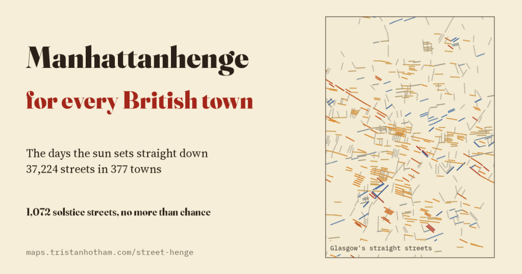
Twice a year New York stops to watch the sun set straight down its cross streets. Every British town has its own Manhattanhenge, on its own dates. I worked them out for 37,224 straight streets in 377 towns and cities, with the hills on the skyline, and checked the famous claim about Milton Keynes. It misses.
Manhattan’s streets are laid out on a grid turned about 29 degrees from north, and on a few evenings around late May and mid July the setting sun sits exactly at the end of the cross streets, framed by the towers. Crowds turn out to photograph it. It is a lovely thing, and there is nothing special about Manhattan except the straightness of its streets. Any long straight street that runs roughly east to west lines up with the rising or setting sun on one or two days a year. The question is which days, and which streets.
So I took the street map of every UK town and city with more than 25,000 people from OpenStreetMap, joined each named street end to end, and looked for stretches that run dead straight for at least 300 m. There are 37,224 of them, 15,638 km in all. For each one, looking each way along it, I worked out the skyline at the end of the view from terrain data, and then the days when the sun stands on that skyline exactly down the street.
Half the streets catch the sun
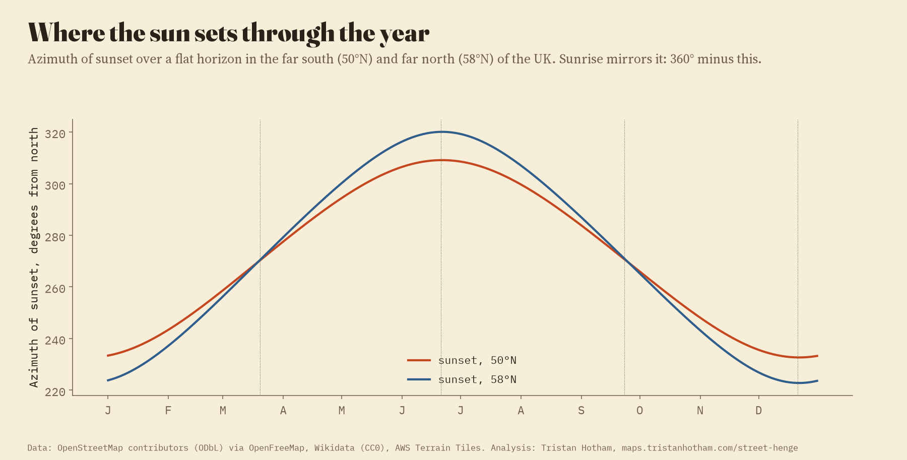
The sun only rises and sets inside two arcs of the compass, which widen as you go north. In Cornwall the midsummer sun sets at about 309° from north and the midwinter sun at about 233°; in the far north of Scotland the swing runs from 223° to 320°. Streets that run near north to south never catch it. Of the straight streets, 49% line up with the rising or setting sun on at least one day of the year.
A thousand solstice streets
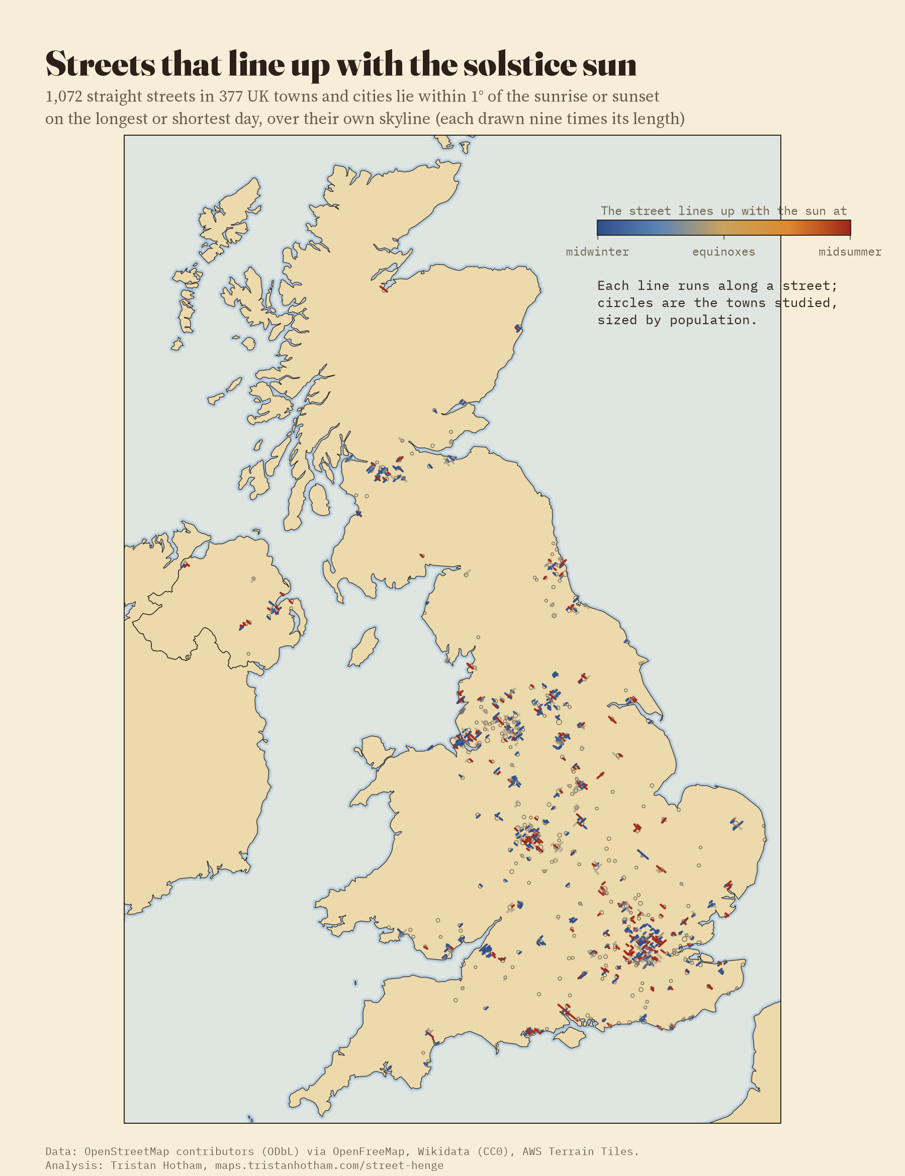
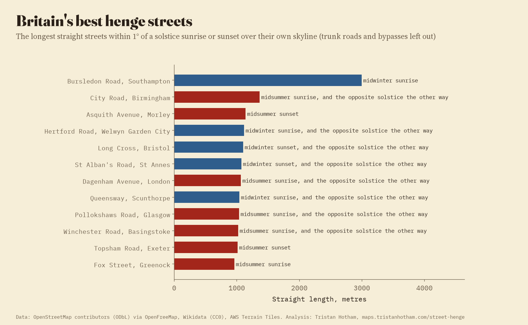
1,072 streets line up within a degree with the sunrise or sunset on the longest or the shortest day. Many work both ways, like Stonehenge: a street that points at the midsummer sunrise at one end usually points at the midwinter sunset at the other. The longest true street among them is Bursledon Road in Southampton, 2,995 m without a bend, pointing at the midwinter sunrise. Then come City Road in Birmingham and Asquith Avenue in Morley.
But were any of them built that way? If the people who laid out British towns had cared about the solstice, there would be a spike in the number of streets pointing exactly at it. There is not. Within a degree of a solstice there are 1.86% of street ends; a few degrees either side there are 1.83% per two degrees. British streets point at the solstice about as often as chance would give. A handful of towns, St Annes on the Fylde coast and Bournemouth above all, have more solstice streets than they should, but only because their grids happen to run that way.
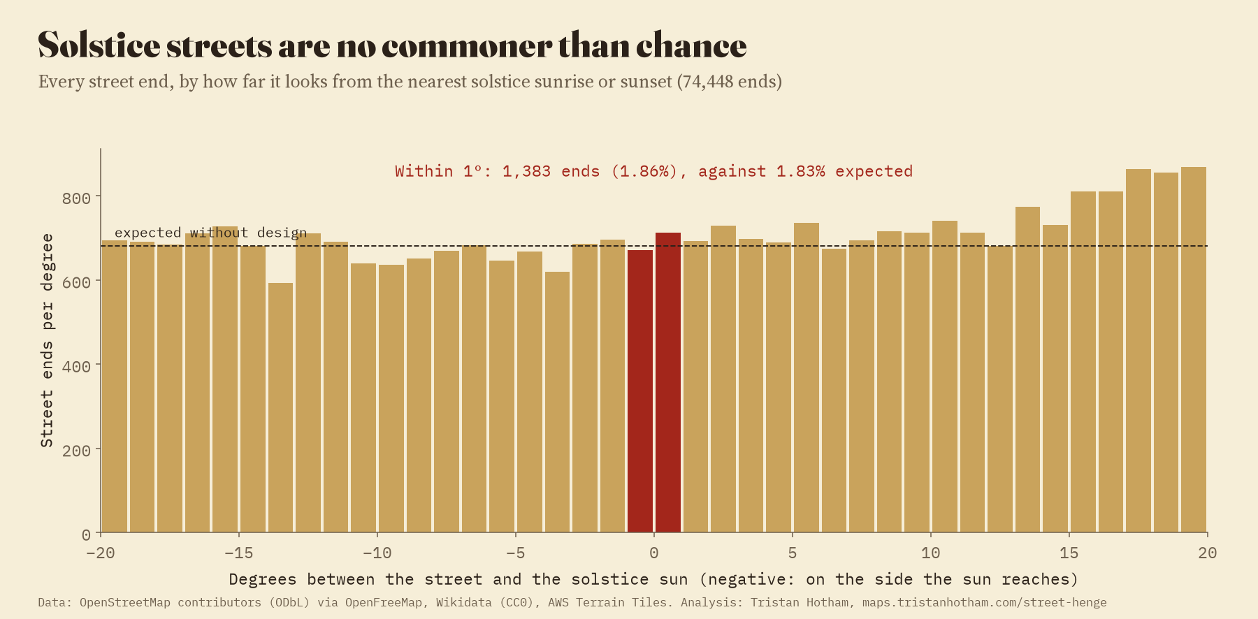
British streets point at the solstice about as often as they would if nobody had ever thought about the sun.
Midsummer Boulevard misses midsummer
The one British street that is supposed to have been built for the sun is Midsummer Boulevard, the spine of central Milton Keynes, which is often said to point at the midsummer sunrise. In OpenStreetMap it runs at 55.1° from north. The midsummer sun rises over its eastern skyline at about 50.1°. That is a miss of 4.0° or more, about eight times the width of the sun. The sun does rise straight down Midsummer Boulevard, but about 24 May and 20 July, a month either side of midsummer.
To be fair to the planners, they never claimed much more. David Lock, who planned the city centre, said you could tell people that on Midsummer’s Day the sun rises at the end of it, “which it nearly does”. The chief architect, Stuart Mosscrop, said the first match with the solstice was a coincidence, and that they then moved the grid slightly to suit it. The later story, of astronomers at Greenwich fixing the exact angle, does not fit the street. What does hold is this: on midsummer morning the sun stands straight down the boulevard about 36 minutes after it first appears, once it is 3.6° up. Stand at the low western end by the station and look up the hill, and the rise of the road, its trees and the buildings on the crest make a skyline about that high, so the sun can seem to come up right at the end of the boulevard. From the open eastern end, looking out over the valley, it rises well to the left.
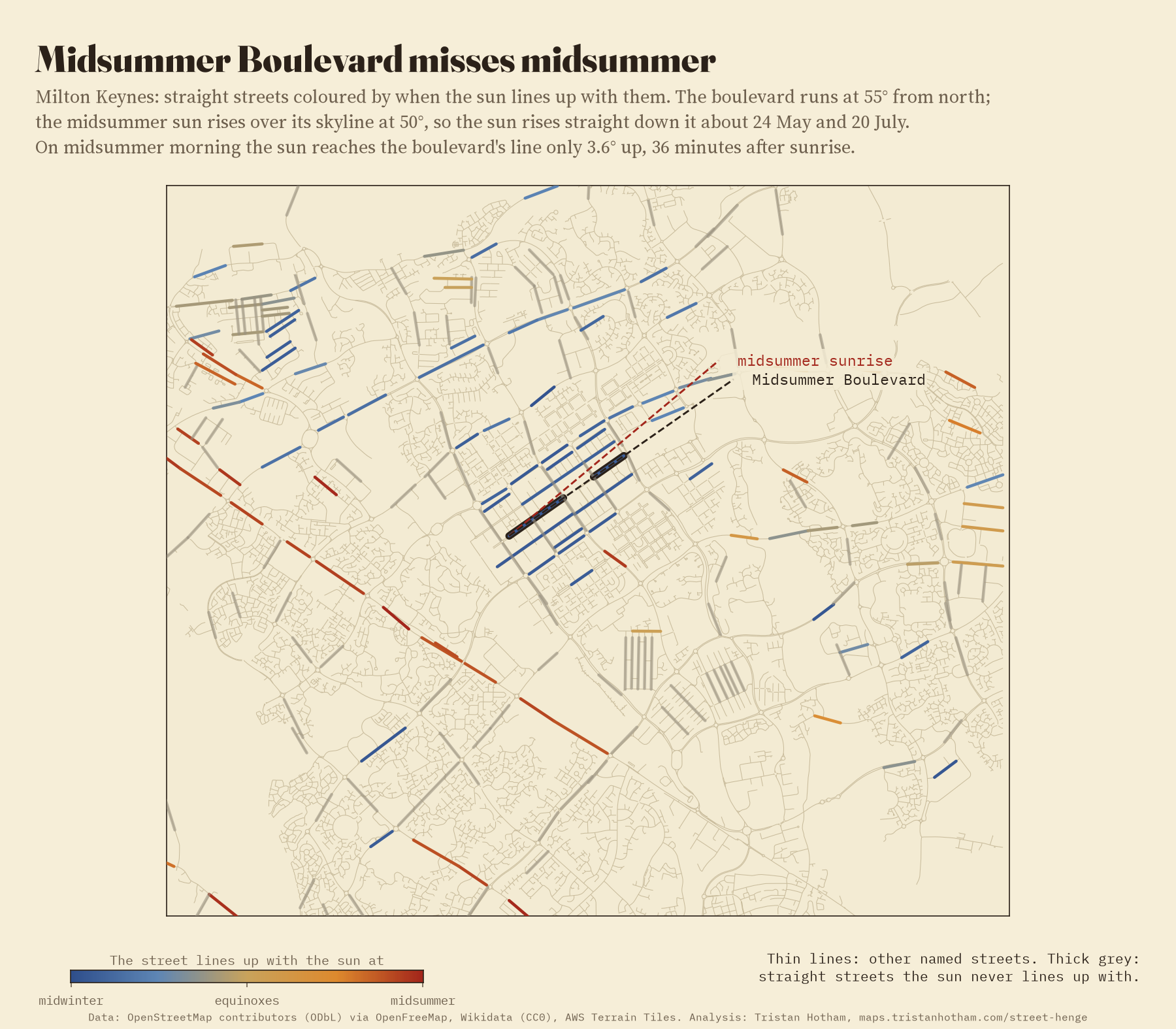
Your town’s henge days
Add up the metres of street that the sun lines up with, day by day, and every town gets a henge calendar. Grid cities have clear henge days. Glasgow’s grid is turned only 9° from north, so the sun sets straight down its east to west streets in early April and again in September; its best days are 6 April and 7 September. Edinburgh’s New Town gets its sunsets in late February and mid October. The tidiest grids of all are in seaside resorts laid out square to the shore, Great Yarmouth, Worthing and Southend, whose streets catch the sun close to the equinoxes. The map lets you pick any town, see its streets coloured by season, and slide through the year to watch them light up.
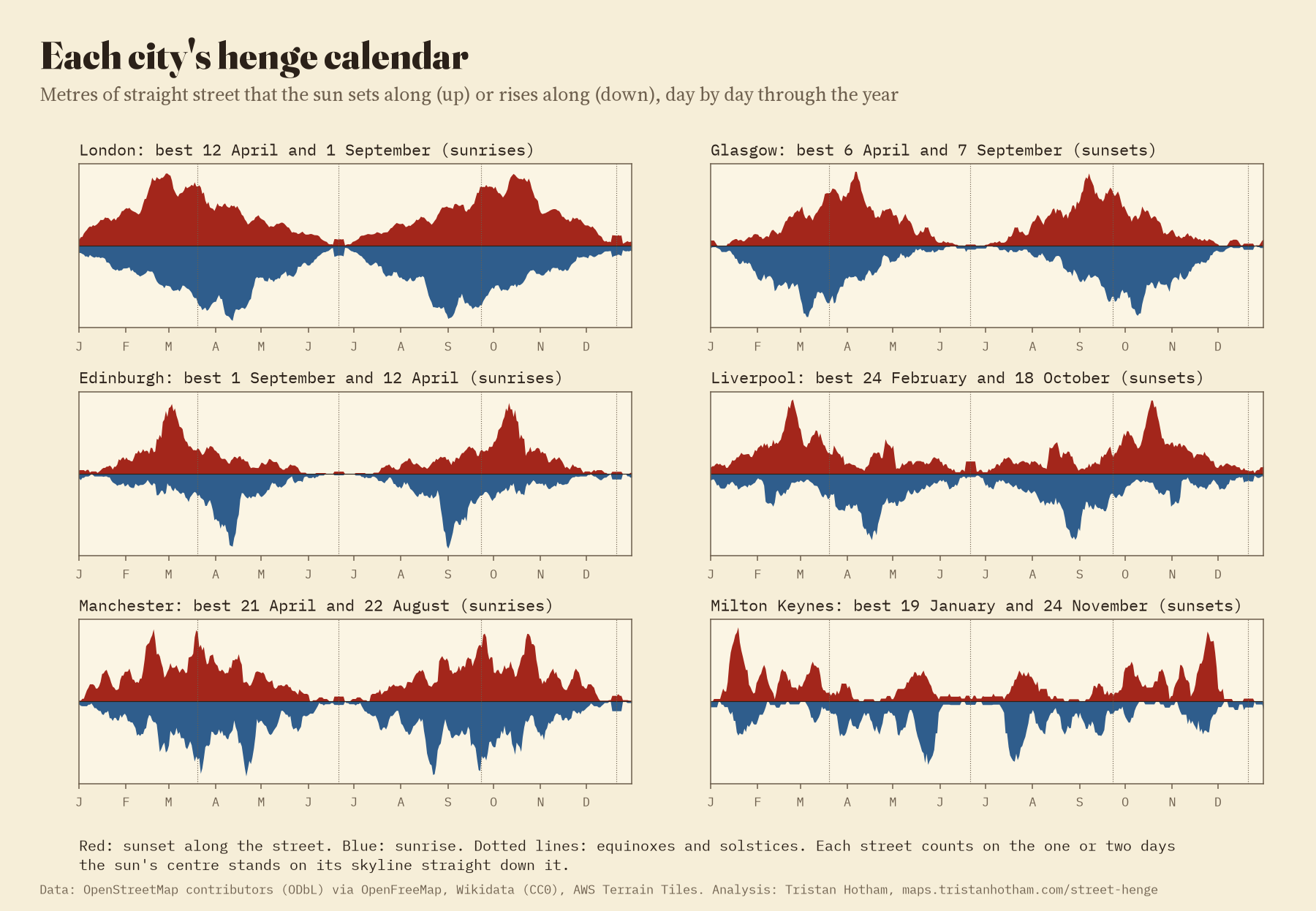
What it cannot see
The skyline here is the land’s, from terrain data about 95 m across. Buildings, trees and the bend in a street just beyond its straight stretch are not in it, so plenty of these alignments will be hidden behind a warehouse. The dates are for the moment the sun’s centre sits on the skyline, and shift by a day from year to year. And a straight stretch has to run at least 300 m, so shorter streets are left out.
How I did this
Towns and populations come from Wikidata. Streets come from OpenStreetMap through OpenFreeMap’s vector tiles: named roads, joined end to end, with straight stretches found where every point lies within 5.0 m of the line between the ends. Dual carriageways count once, and trunk roads, bypasses, bridges and piers are kept on the map but left out of the lists. The skyline comes from the AWS Terrain Tiles, out to 40 km, allowing for the curve of the Earth. The sun’s position uses Spencer’s formula and Bennett’s refraction. The code, the full table of streets and their dates, and the paper are linked below.
Notes and sources
- Streets: © OpenStreetMap contributors, Open Database Licence, through OpenFreeMap vector tiles (OpenMapTiles schema).
- Towns and populations: Wikidata (CC0). Terrain: AWS Terrain Tiles (Tilezen).
- Sun: Spencer, J. W. (1971) Fourier series representation of the position of the sun, Search 2(5), 172; Bennett, G. G. (1982) The calculation of astronomical refraction in marine navigation, Journal of Navigation 35(2), 255 to 259.
- Street grids: Boeing, G. (2019) Urban spatial order: street network orientation, configuration, and entropy, Applied Network Science 4, 67.
- Midsummer Boulevard: David Lock as quoted from Hill, M. (ed.) (2007) The Story of the Original Central Milton Keynes, Living Archive Milton Keynes; Stuart Mosscrop as quoted by The Parks Trust, Mysticism in the park, Campbell Park heritage trail.
- Paper: Hotham, T. (2026) Manhattanhenge for every British town. Zenodo, 10.5281/zenodo.24075297.
- I wrote the text, with drafting and editing assistance from Claude (Anthropic), which also helped prepare the analysis code. I reviewed and checked all text and results.

