
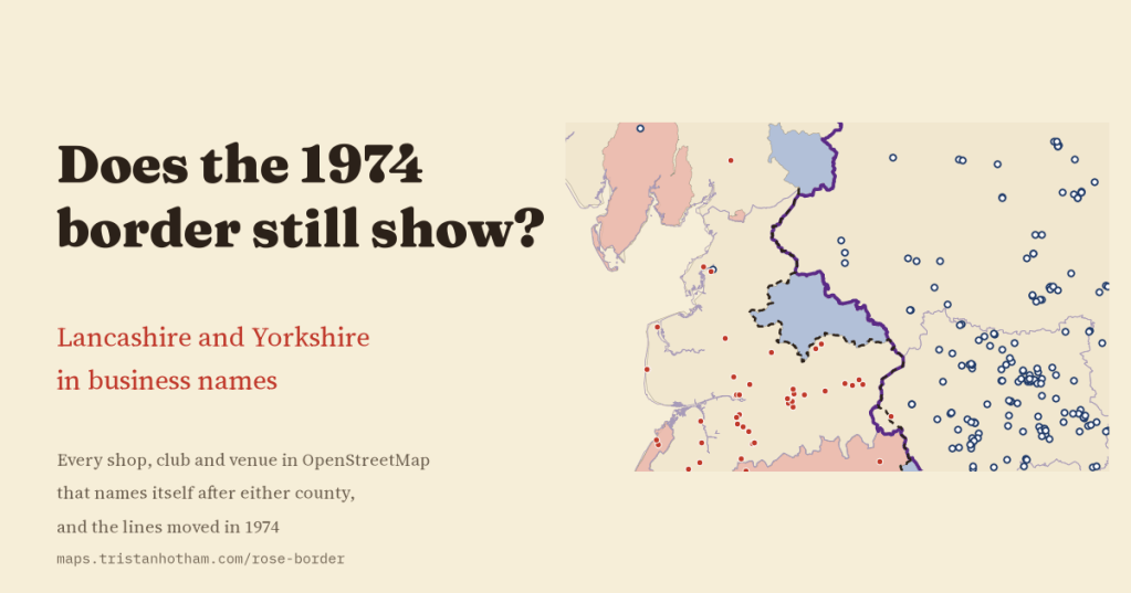
In 1974 the map of northern England was redrawn, and towns that had been in Yorkshire for centuries woke up in Lancashire, while Manchester and Liverpool left Lancashire altogether. Fifty years on, I wanted to know which county local businesses still put on their signs. So I mapped every shop, club and venue in OpenStreetMap that names itself after either rose. The main test I set myself in advance, in the places that moved from Yorkshire to Lancashire, could not be answered, because there are no county-named businesses there on the map. What the map does show is a sharp line where the old border did not move, and the Lancashire name thinning in Greater Manchester and Merseyside.
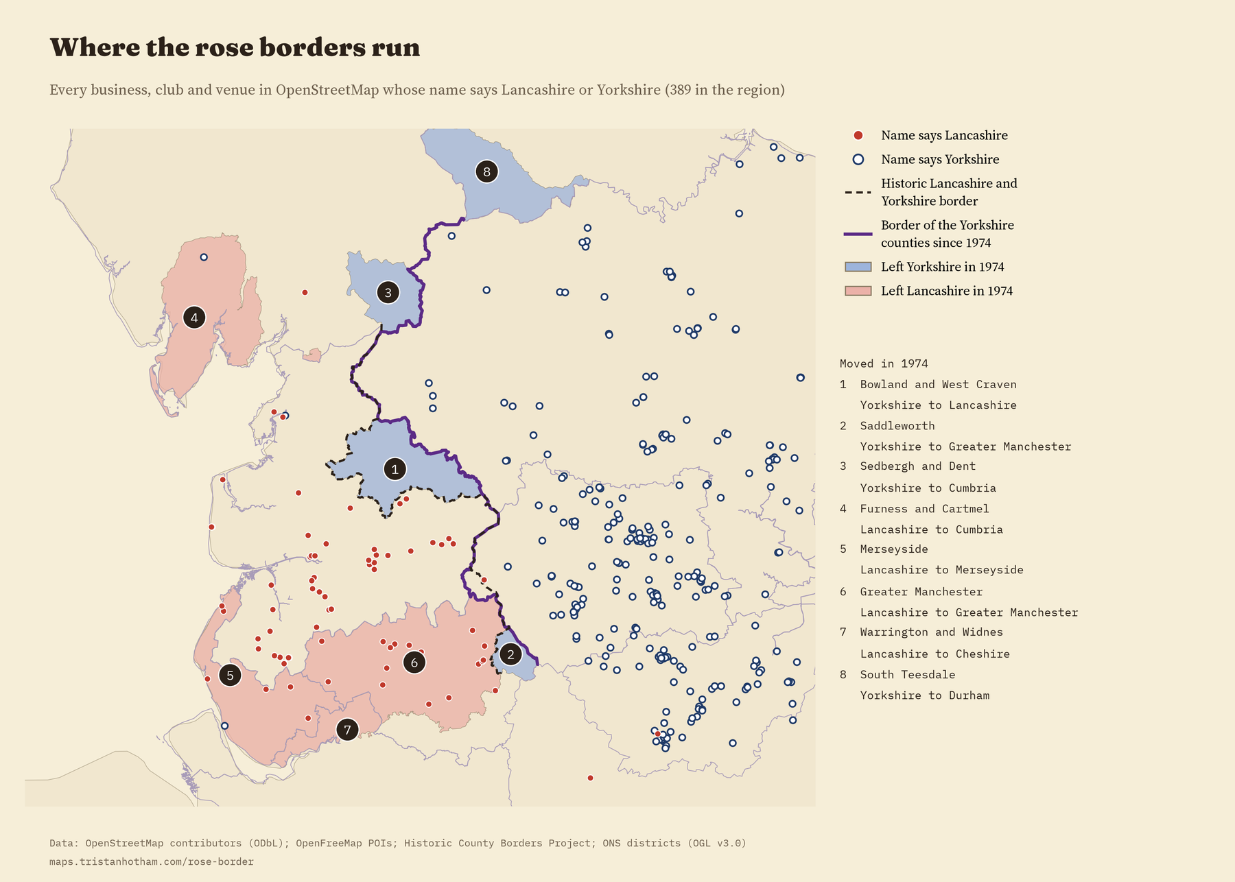
The Local Government Act 1972 came into force on 1 April 1974, and it moved a lot of places. The Forest of Bowland, Barnoldswick and Earby went from the West Riding of Yorkshire into Lancashire. Saddleworth went into Greater Manchester, and Sedbergh and Dent into the new county of Cumbria. Lancashire lost Furness and Cartmel to Cumbria, Warrington and Widnes to Cheshire, and its two great cities to the new metropolitan counties of Greater Manchester and Merseyside. People have argued ever since about whether the old counties still exist.
Arguments are hard to measure. Names are easier. A café that calls itself “Yorkshire” or a builder that calls itself “Lancashire” is making a small, public claim about where it belongs. So I took every feature in OpenStreetMap whose name says Lancashire, Lancs, Yorkshire or Yorks, threw out the roads, bus stops, railways, memorials and street names, set aside the branches of big chains and the public bodies, and was left with 389 businesses, clubs and venues in and around the two counties.
Cross the line and the rose changes
Where the old border between the two counties did not move, it is sharp. Within 25 km of the line on the Yorkshire side, 59 of the 60 county-named businesses say Yorkshire. On the Lancashire side, 1 of 36 does. Walk over the moors from Colne to Keighley and the name above the door flips from one rose to the other.
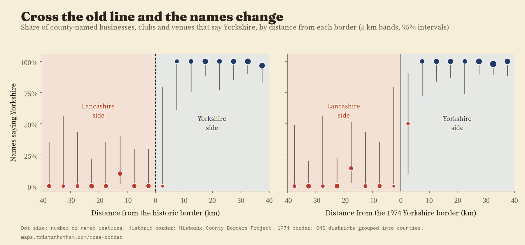
To check that this is the border and not just a gradual drift from west to east, I drew two false borders, 10 km inside each county, and measured the same jump across them. Across the real line the share saying Yorkshire jumps by 86 percentage points; across the false ones it changes by -8 and 14 points, and neither change can be told apart from zero.
Greater Manchester and Merseyside still say Lancashire, more quietly
The trouble with a sharp line is that along most of its length the old border and the new one are the same, so it cannot tell me which one people are following. The places that moved can. And the biggest of them are the parts of Lancashire that became Greater Manchester and Merseyside.
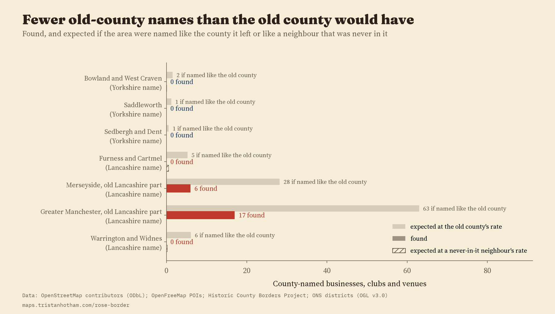
To compare a city with the Ribble Valley fairly, I counted every named shop, pub, café and office on the map as well, and worked out county names per 1,000 of them. Inside today’s Lancashire there are 4.1 Lancashire names per 1,000 businesses. In the old Lancashire part of Greater Manchester there are 1.1, and in the old Lancashire part of Merseyside 0.9. That is about a quarter of the Lancashire rate in Greater Manchester and a fifth in Merseyside: the county cricket club, a maker of Eccles cakes, a florist, carpenters, lawyers and a brick merchant. But the parts of the same two counties that were never in Lancashire, Stockport, Sale, Altrincham and Hyde, and the Wirral, have none at all, where about 5 would be expected at the rate of their neighbours over the old boundary. That last comparison was not in my plan, so treat it as exploratory, and the whole section as the secondary part of the study.
Fifty years after leaving Lancashire, its old parts of Greater Manchester and Merseyside still have businesses named after it, at a quarter to a fifth of the rate. Across the old Cheshire line, in the same counties, I found none.
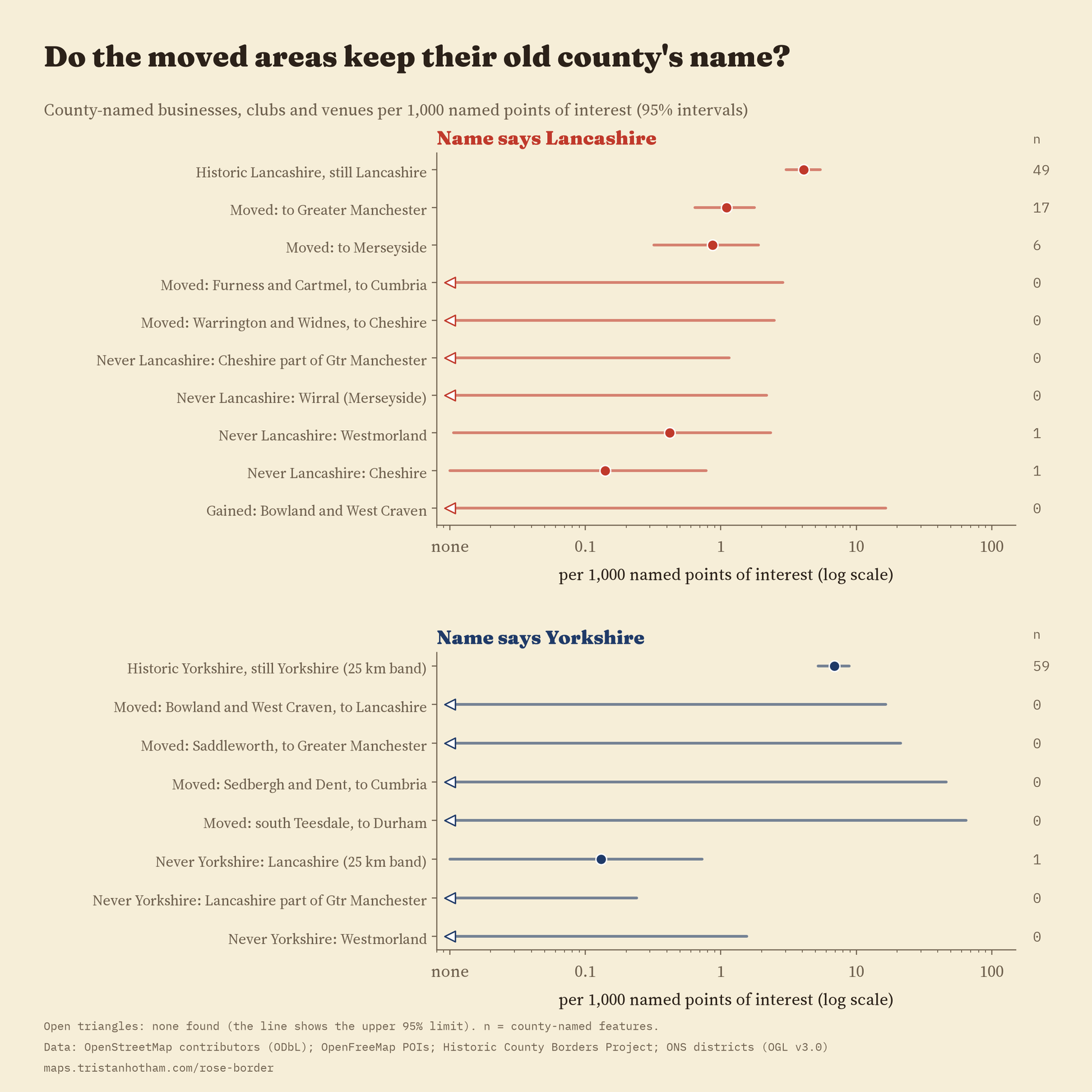
Further out, I found none. Furness and Cartmel, across Morecambe Bay and now in Cumbria, have no Lancashire-named businesses on the map, where about 5 would be expected at Lancashire’s rate. Warrington and Widnes, now in Cheshire, have none either, where about 6 would be expected. I cannot say whether the name faded after 1974 or was never much used there: a name on a map does not come with a date.
The question I could not answer
The question I most wanted to answer, and the main test in my written plan, was about the other direction: do businesses in Barnoldswick, Earby, Slaidburn and Saddleworth still call themselves Yorkshire? The answer is that the map cannot tell. Those places, with Sedbergh, Dent and south Teesdale, have 534 named businesses on OpenStreetMap between them, and not one is named after either county. Even at Yorkshire’s own rate only about 4 would be expected, so an empty map is not a verdict. The only Yorkshire name in Barnoldswick is a branch of a national building society, which tells you where the firm started, not what the town thinks.
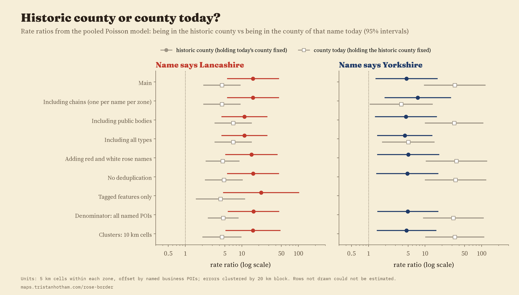
Putting everything on both maps at once gives a summary for Lancashire: places in historic Lancashire have about 16 times the rate of Lancashire names even outside today’s county, and places in today’s Lancashire a further 4.5 times. Both maps line up with the names, though this cannot say why. For Yorkshire the same model is too thinly supported to trust.
How I did this
The names come from OpenStreetMap, the map that volunteers build. I read every name within 40 km of the border, and in every area that moved, by eye, and kept a file of 75 decisions: bus routes named after shopping centres, war memorials, a golf club mapped twice, and a car dealer whose name turned out to be its founders’ surname. The historic counties come from the Historic County Borders Project, and today’s counties from the 2023 district boundaries. For fairness between busy cities and quiet valleys I counted 106,414 named businesses and venues in the region from OpenFreeMap. I wrote the analysis plan before computing any share or rate by area, and the paper reports it as planned, including the test that could not be done.
There are real limits. OpenStreetMap is patchier in some places than others. A name does not tell me when it was chosen, so a firm named in 1960 looks the same as one named last year. People name businesses after where they grew up, what they sell or who they want to sell to. And registered company names, which would be a much bigger source, were not available to me for this study. So this is a picture of the names on today’s map, not a measure of what people feel.
Notes and sources
- Names and points of interest: OpenStreetMap contributors, queried through QLever and read from OpenFreeMap vector tiles, 2026. Open Database Licence (ODbL).
- Historic counties: this map made use of data provided by the Historic County Borders Project. Districts: ONS, December 2023 (Open Government Licence v3.0).
- Further reading: J. S. Reed, “The heart of Dixie: an essay in folk geography”, Social Forces (1976); W. Zelinsky, “North America’s vernacular regions”, Annals of the Association of American Geographers (1980); K. Zimmerbauer, S. Riukulehto and T. Suutari, “Killing the regional Leviathan?”, International Journal of Urban and Regional Research (2017); D. Russell, Looking North (2004).
- I wrote the text, with drafting and editing assistance from Claude (Anthropic), which also helped prepare the analysis code. I reviewed and checked all text and results.

