
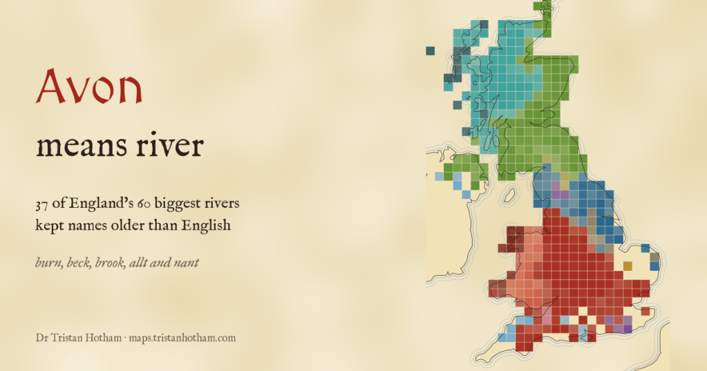
The River Avon is, in the language of the people who named it, the River River. I mapped every named river and stream in the UK by the words in their names, and found the oldest layer of language in the landscape, and a line drawn by the Vikings that still runs across England.
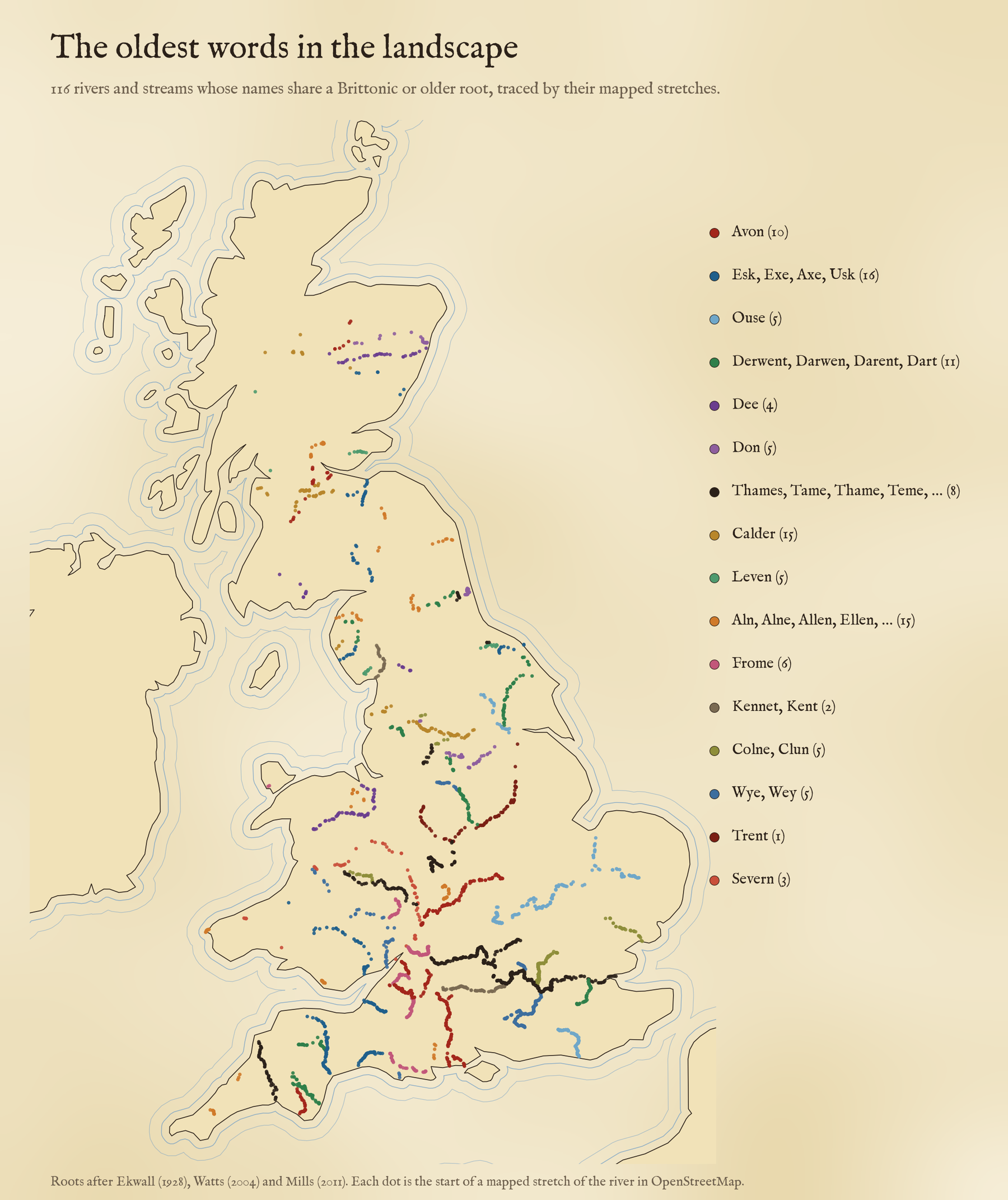
Avon is the old Brittonic word for a river. It survives as afon in Welsh, and when English speakers arrived in the fifth and sixth centuries they heard it as a name. So Stratford-upon-Avon sits, in effect, on the River River. The same thing happened again and again. The newcomers gave English names to almost every farm and village, but for the big rivers they mostly kept the names they found.
I wanted to see how far that holds, so I took 128,210 named stretches of river and stream from OpenStreetMap, joined them into 32,068 named watercourses, and sorted the names two ways: by the ancient root of the name, and by the everyday word people put beside it, like burn, beck, brook, allt and nant.
The villages changed, the rivers did not
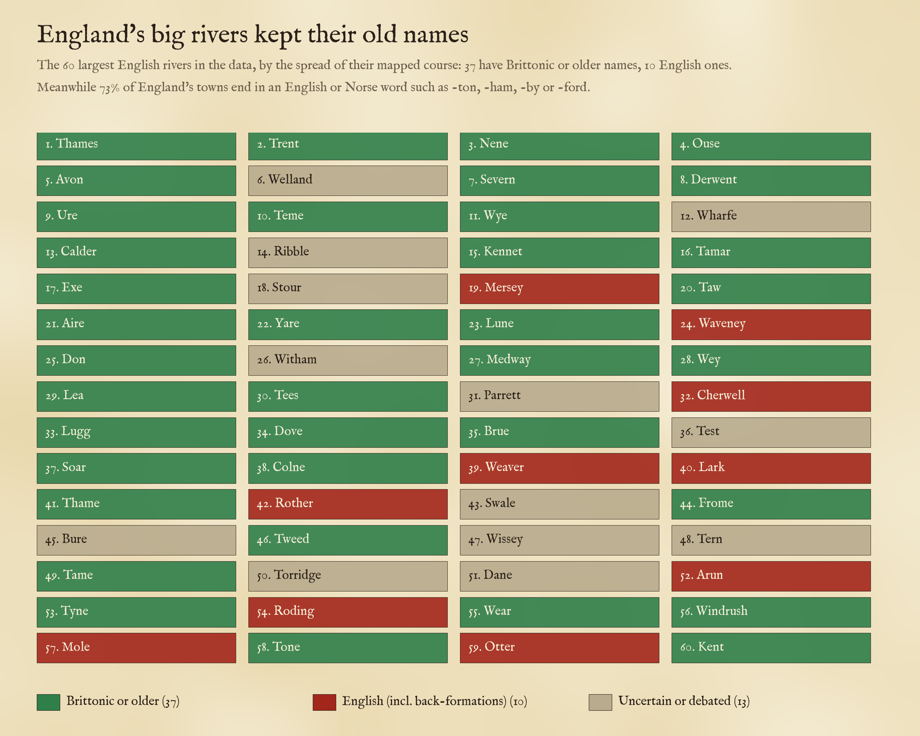
England’s towns have English names. Of 1,184 towns and cities, 73% have a first word ending in a plain English or Norse word like -ton, -ham, -ley, -ford or -by. Now take the 60 biggest English rivers in the map. Going by the standard works on river names, 37 of them have names that are Brittonic or older: the Thames, Trent, Severn, Avon, Ouse, Derwent, Exe, Tamar, Tees and Tyne among them. Only 10 are English, like the Mersey (the boundary river) and the Weaver (the winding one), and some of those were made up centuries later from the name of a town: the Arun from Arundel, the Rother from Rotherfield, the Mole from Molesey. The rest are still argued over.
Often the newcomers named their towns after the river instead: Exeter on the Exe, Dartmouth on the Dart, Alnwick on the Aln, Doncaster on the Don, Tynemouth. Within 6 kilometres of the old-named rivers I found 123 towns and villages carrying the river’s name.
73% of England’s towns have English names. 37 of its 60 biggest rivers do not.
How many Avons?
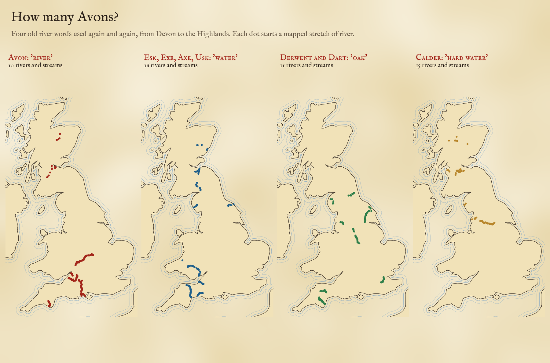
10, by my count: the Warwickshire Avon, the Bristol Avon, the Hampshire Avon through Salisbury, the Devon Avon and more in England, and 4 in Scotland, though some of the Scottish ones may come from Gaelic instead. There are 10 Esks, from Eskdale in Cumbria to the North and South Esks of Angus, which share a root usually read as water with the Exe, the Axe and the Usk. There are 6 Derwents, Darwens and Darents, rivers where oaks grew, and 15 Calders, the hard or rocky waters. Counting these took more care than you might think: OpenStreetMap chops a river into many pieces, so I checked every piece of every one of these 116 rivers by hand.
Burn, beck, brook, allt and nant
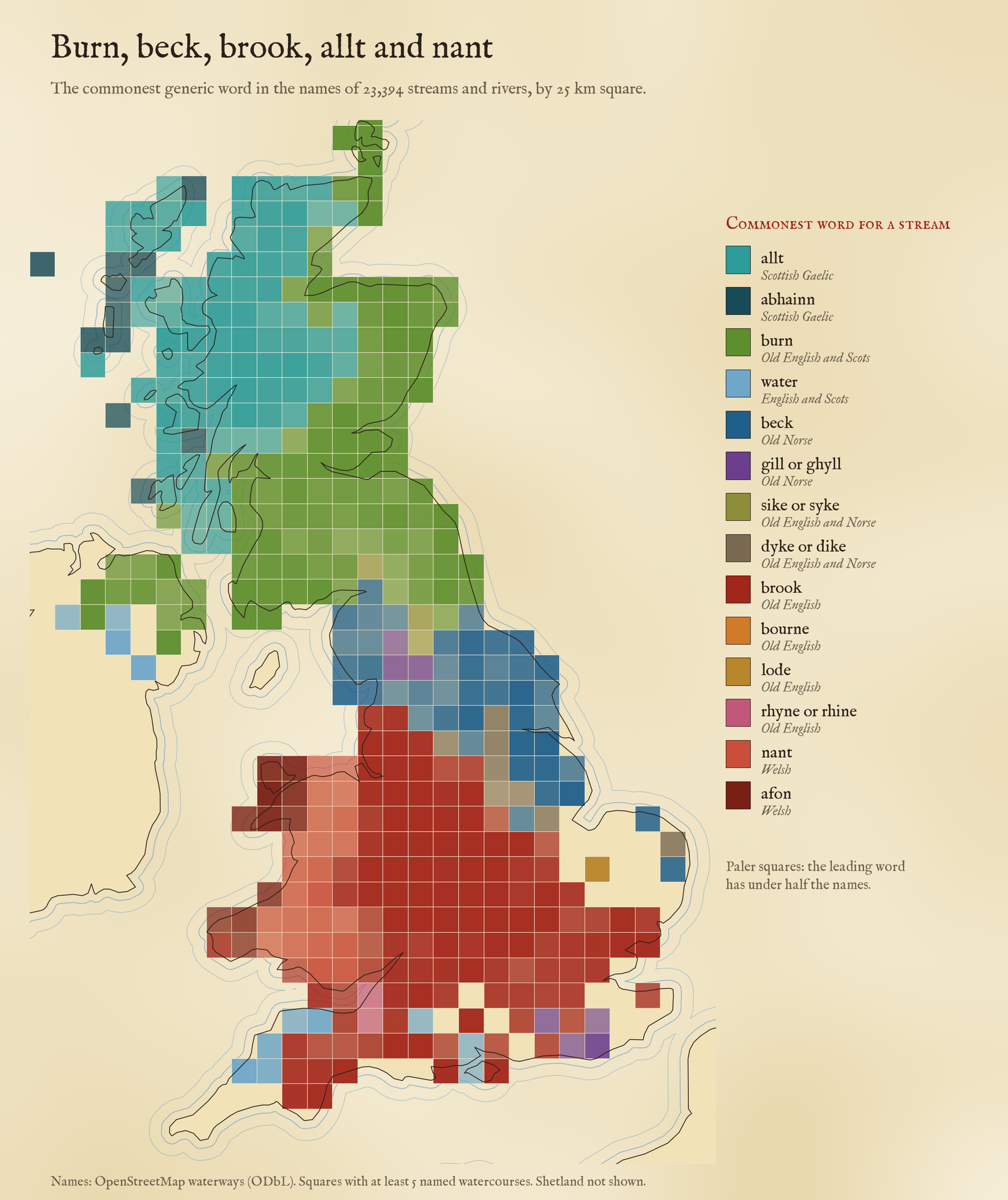
The old names are the specific part. The word beside them is the one people spoke, and it changes as you cross the old language frontiers. In the Highlands a stream is an allt, a Gaelic word: of the Highland streams called allt, abhainn, burn or water, 86% are an allt or an abhainn, and 99% in the Western Isles. Cross into the Borders or Galloway and there are none at all: the streams are burns, waters and sikes. In Wales 86% of the streams named with nant, afon, brook or river are a nant or an afon. In the Midlands and the south it is a brook. On the Somerset Levels the drains are rhynes, and in the Fens they are lodes.
The beck line
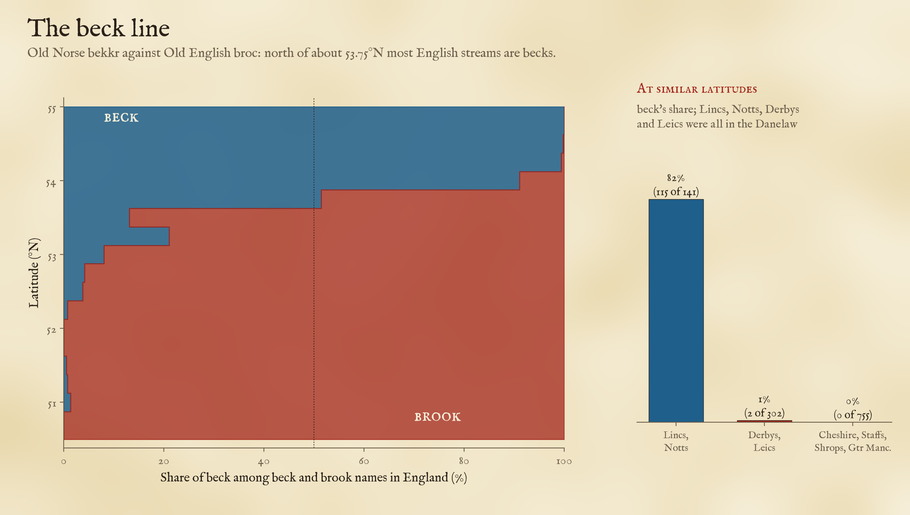
My favourite is the beck. It comes from the Old Norse bekkr, where brook comes from Old English. North of about 53.75 degrees, roughly the latitude of Preston and Leeds, most English streams are becks. But it is not only about latitude. In Lincolnshire and Nottinghamshire, 82% of streams are becks. At much the same latitude in Cheshire, Staffordshire, Shropshire and Greater Manchester, it is 0%: not a single beck among 755 brooks in the map. Lincolnshire’s streams are 96% becks. Oddly, Derbyshire and Leicestershire, which were part of the Danelaw too, are brook country, with 2 becks among 300 brooks, so the beck seems to follow where Norse speakers actually settled thickly, not the political line on the map.
How I did this
The rivers come from OpenStreetMap, which maps them as many short stretches. I joined stretches of the same name that chain together into watercourses, split each name into the generic word (River, Afon, Allt, Burn, Beck, Brook, Water, Gill and so on) and the specific name, and matched the specific names against sixteen groups of old roots taken from Eilert Ekwall’s classic English River-Names (1928), with the place-name dictionaries of Victor Watts and A. D. Mills. I threw out false friends by hand: Kent Water and Kent Ditch are named after the county, not the old river name. For the town comparison I only looked at how each town’s name ends, which is a blunt tool.
The caveats are real. River names are one of the most argued-over corners of place-name study, and I have used the standard readings, not new ones. Some meanings are disputed: the old idea that Thames and Tame mean dark, for example. OpenStreetMap names some regions’ streams far more thoroughly than others, and my size ranking uses the spread of the mapped river, not its true length, so a long river mapped in a few long pieces, like the Cumbrian Eden, can drop out of the 60. So treat single names as leads and the big patterns as the finding. And if your local stream is a beck in brook country, I would love to hear about it.
Notes and sources
- Rivers and places: OpenStreetMap contributors (ODbL), queried with QLever. Counties: ONS boundaries (Open Government Licence v3.0).
- River names: E. Ekwall, English River-Names (1928); V. Watts, The Cambridge Dictionary of English Place-Names (2004); A. D. Mills, A Dictionary of British Place-Names (2011); M. Gelling and A. Cole, The Landscape of Place-Names (2000); H. W. Owen and R. Morgan, Dictionary of the Place-Names of Wales (2007); W. J. Watson, The History of the Celtic Place-Names of Scotland (1926).
- I wrote the text, with drafting and editing assistance from Claude (Anthropic), which also helped prepare the analysis code. I reviewed and checked all text and results.

