
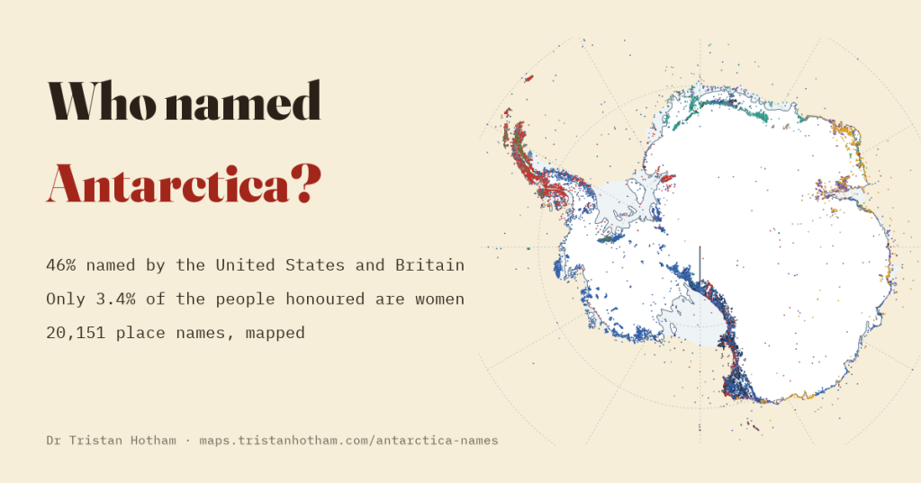
Antarctica has never had a native people, yet it has more than twenty thousand place names, almost all of them given in the last two centuries by two dozen nations at once. I mapped 20,151 of them: who named each one, when, and after whom. America and Britain named almost half of its features, and only about one in thirty of the people honoured is a woman.
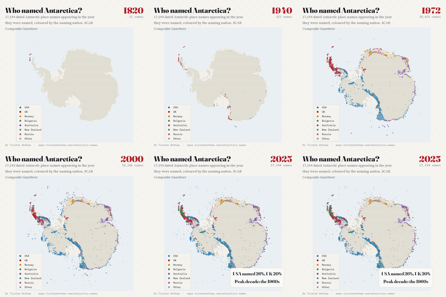
Every other continent was named slowly, by the people who lived on it, in languages that are often long gone. Antarctica was named in a hurry by visitors. Sealers and naval expeditions gave the first names in the 1820s and 1840s, the explorers of the heroic age added more, and then, after the Second World War, aircraft photographed the interior and survey parties found tens of thousands of mountains, glaciers and nunataks that needed names. National committees in Washington, London, Canberra, Wellington and elsewhere were set up to decide them.
The Scientific Committee on Antarctic Research keeps a Composite Gazetteer of Antarctica that puts the national lists of 25 countries side by side: 39,187 names for 20,151 features, once the same feature listed by several countries is counted once. Most entries carry a short story of how the place was named. I read those stories with a set of rules, checked them by hand where it mattered, and linked the people to Wikidata to find where they were born. On the interactive map you can click any of the twenty thousand names and see who named it, when and after whom, and where that person was born.
America and Britain
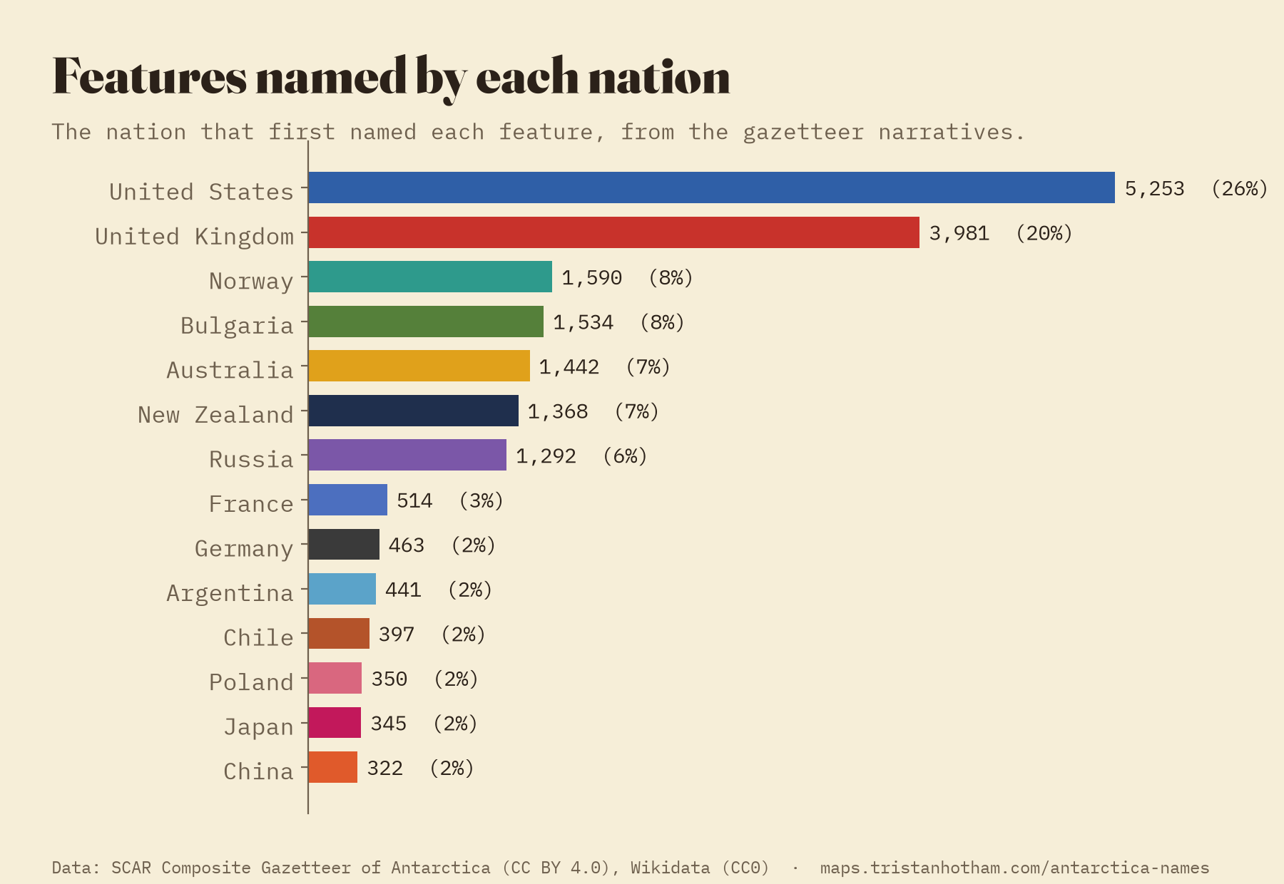
The United States named 5,253 features, 26% of the total, most of them through its Advisory Committee on Antarctic Names for features photographed by US Navy aircraft. The United Kingdom named 3,981 (20%), above all on the Antarctic Peninsula, surveyed for decades by the Falkland Islands Dependencies Survey and the British Antarctic Survey. Then come Norway, Bulgaria, Australia, New Zealand and Russia, each with between 6 and 8 per cent.
Naming as a claim
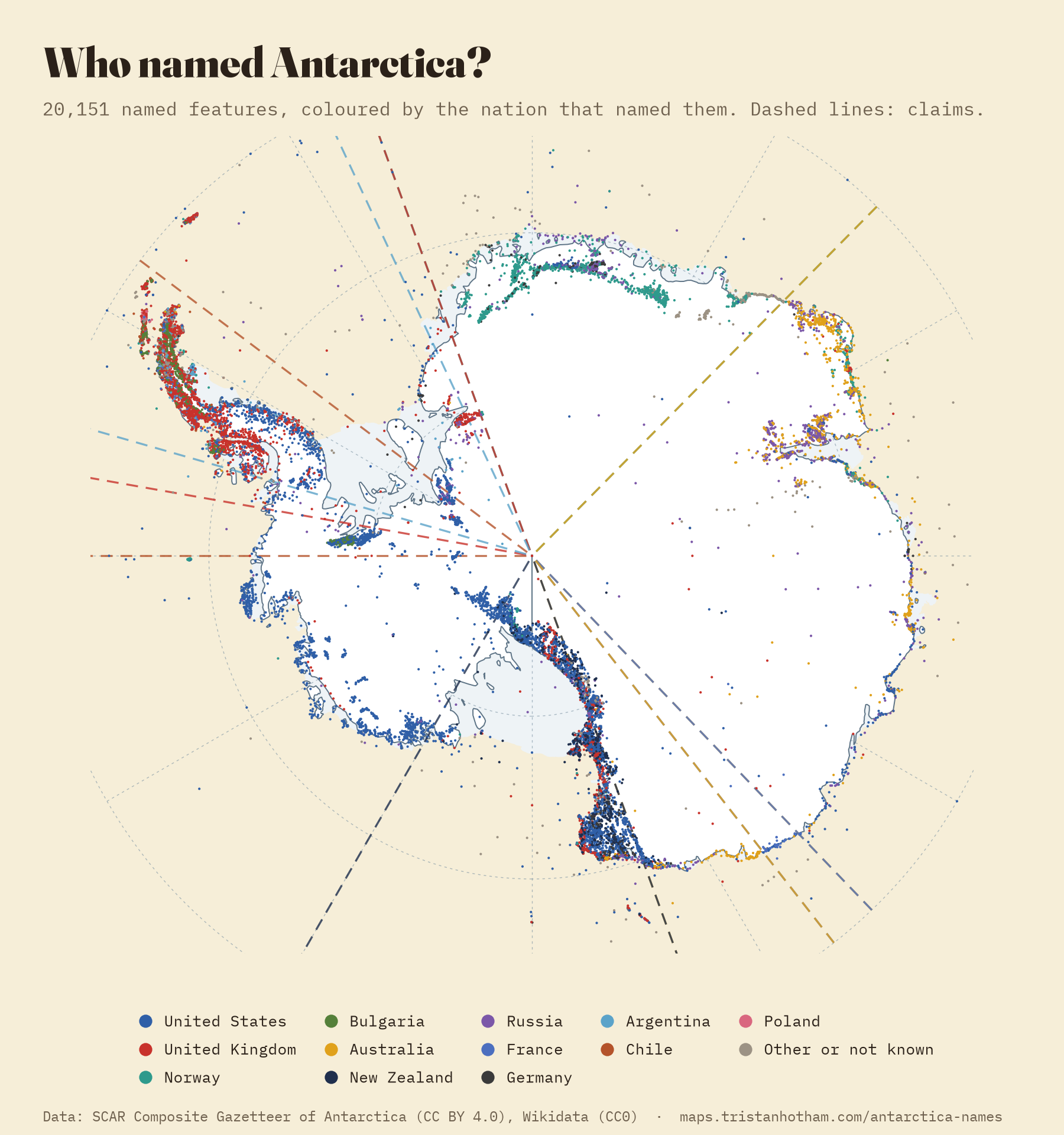
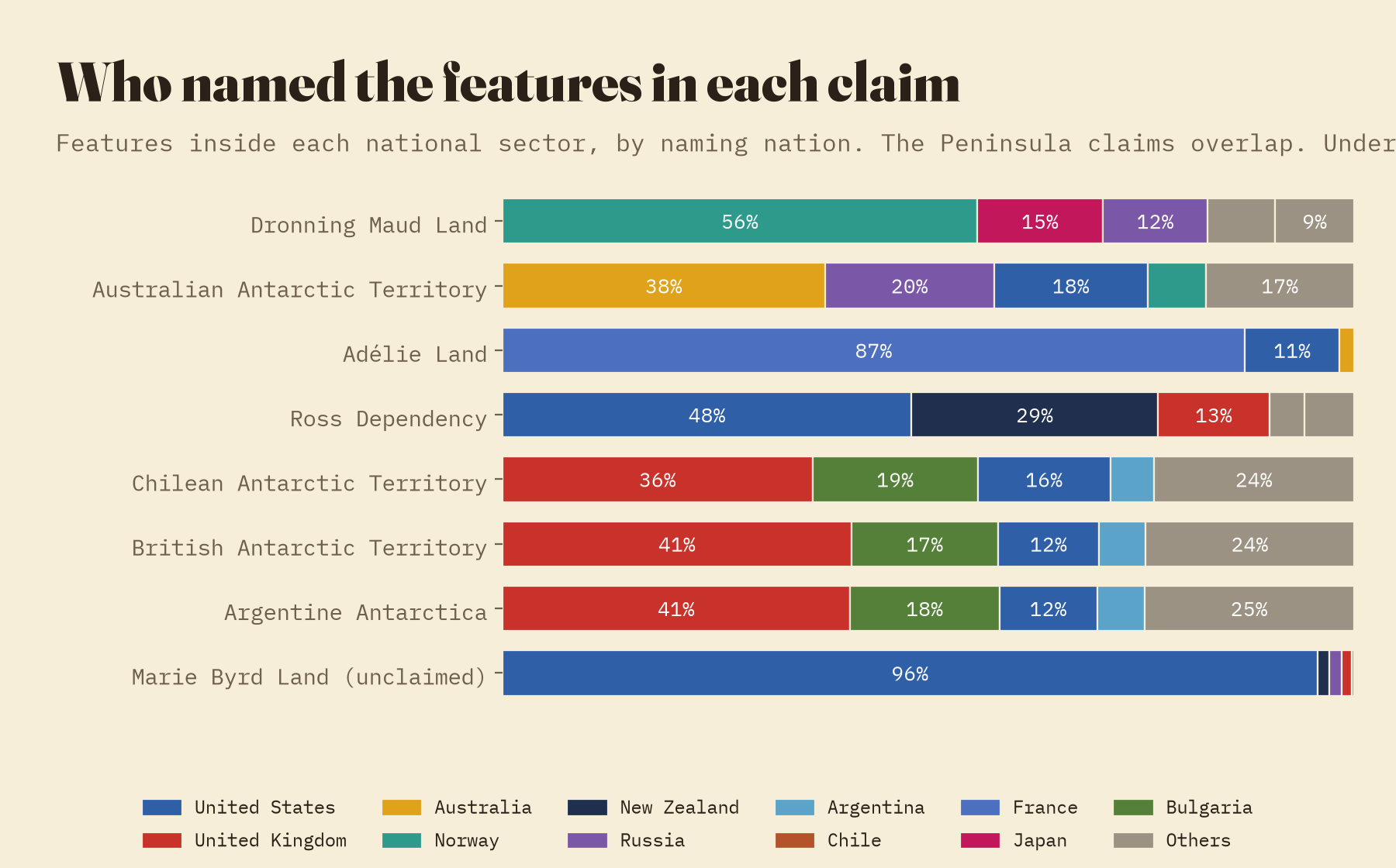
Seven countries claim slices of Antarctica, frozen but not given up under the Antarctic Treaty of 1959, and naming a place is an old way of saying it is yours. The claimants do mostly name inside their own claims: 99.5% of Argentina’s names and 96% of Australia’s lie in their own sectors. But none of them names most of what it claims. Australia named 38% of the features in the Australian Antarctic Territory. The United States, which claims nothing, named 48% of the features in New Zealand’s Ross Dependency and 96% of unclaimed Marie Byrd Land. On the Peninsula, which Argentina, Chile and Britain all claim, Britain named 41% of the features inside the Argentine claim, and Argentina just 5.5%.
The great naming of the 1960s
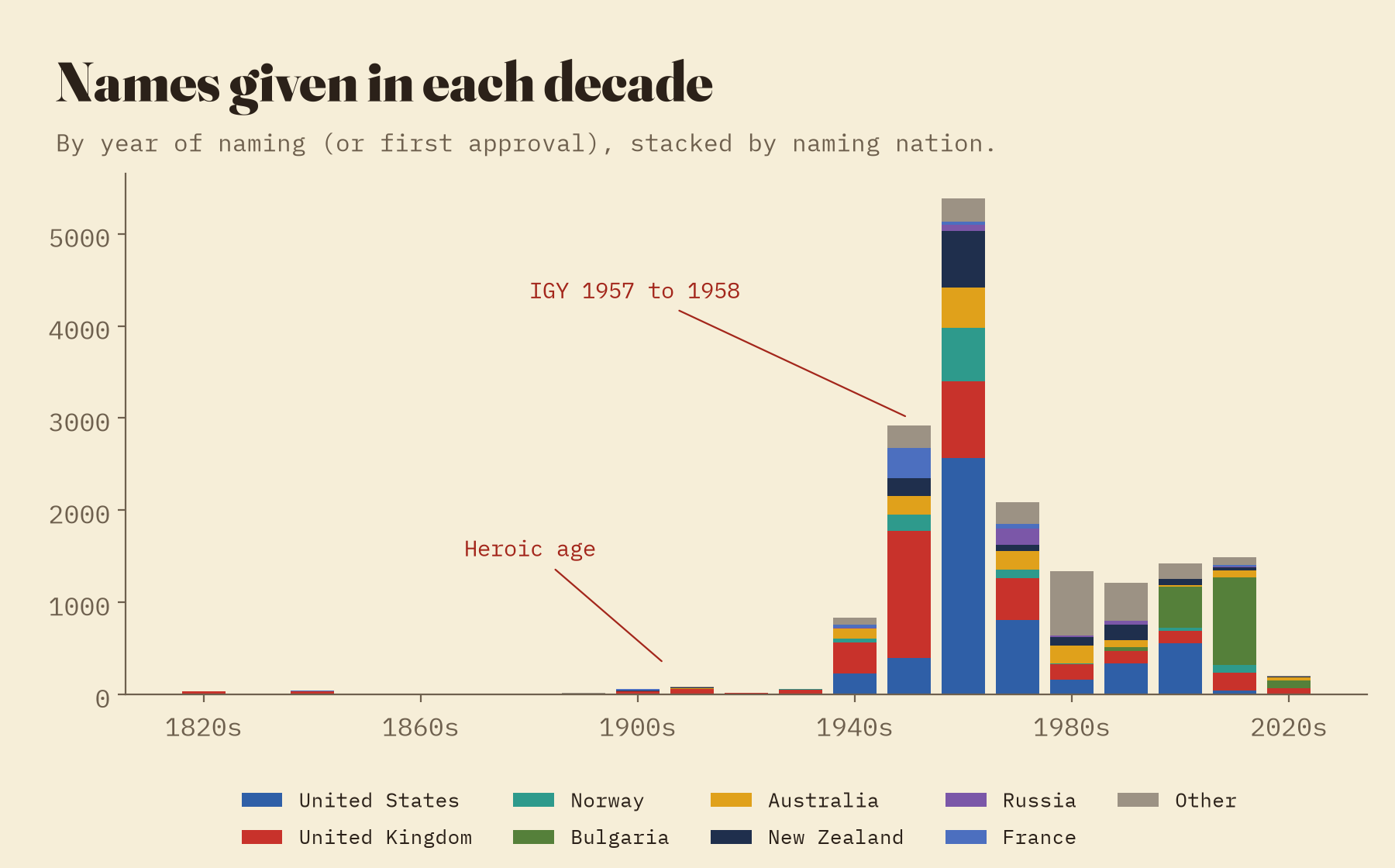
Only 148 of the dated names carry a date from the heroic age of Amundsen, Scott, Shackleton and Mawson, though many more were given then and are dated here by a later approval. The flood came after the International Geophysical Year of 1957 to 1958, when permanent stations and aircraft opened the interior: 7,472 features, 43% of all the dated names, were named between 1960 and 1979, nearly half of them by the United States. Naming has not stopped. 18% of dated names were given in 2000 or later, and 48% of those are Bulgarian.
People, shapes and Bulgarian towns
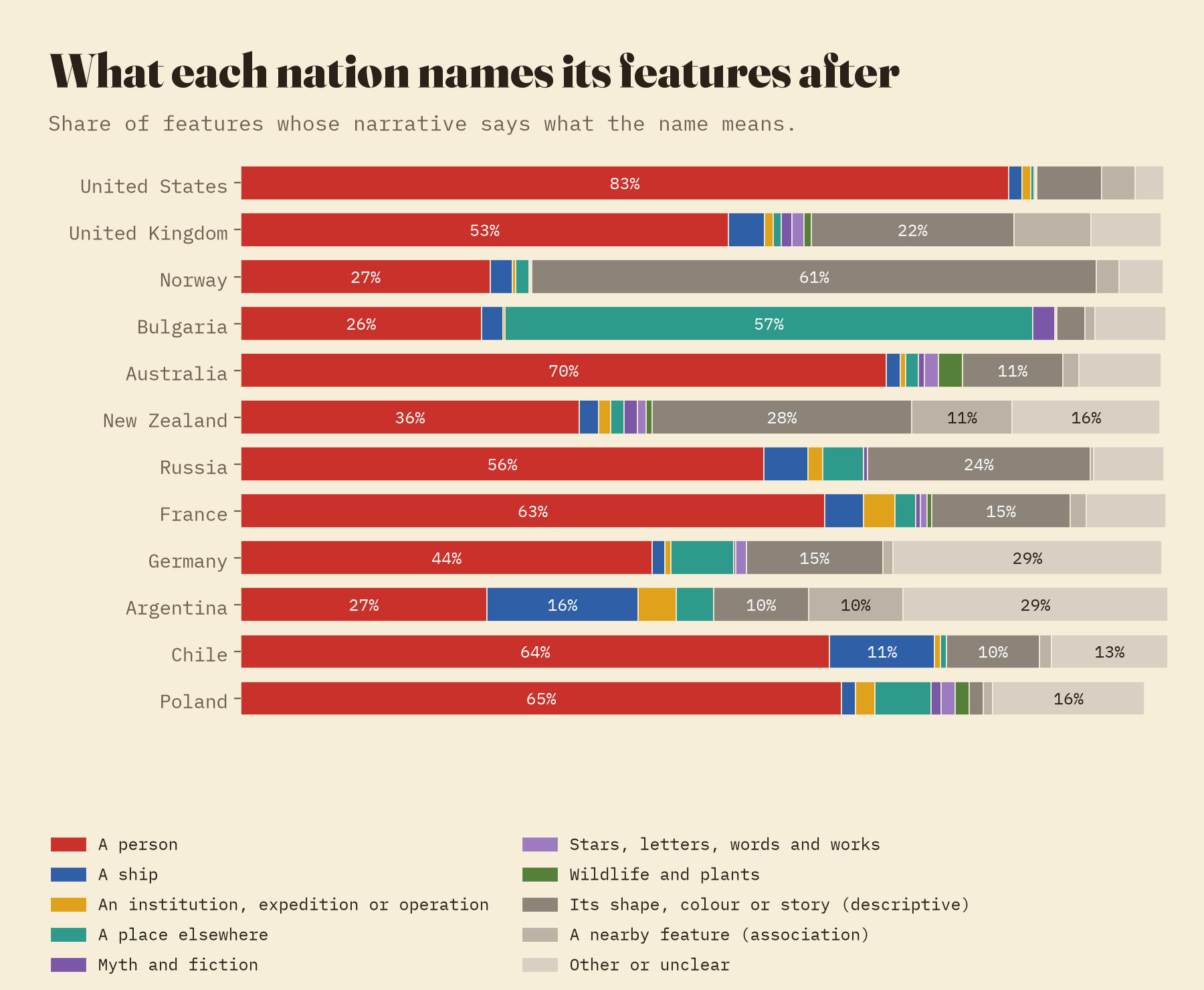
Where the gazetteer says what a name means, 57% honour a person, 18% describe the place and the rest are ships, places elsewhere, nearby features, gods, stars and the occasional dog. But nations name in very different ways. 83% of American names honour a person. Norway and Japan describe: 61% of Norwegian names and 86% of Japanese ones say what a place looks like, from Skakktoppen, the crooked peak, to Mikazuki Iwa, crescent rock. And Bulgaria, which started naming in earnest only this century, names after home: 57% of its names are Bulgarian towns, villages, rivers and mountains, scattered across the South Shetland Islands and the Peninsula.
The commonest surnames on the map of Antarctica are Smith, Davis, Brown, Johnson and Wilson.
Cooks, pilots and patrons
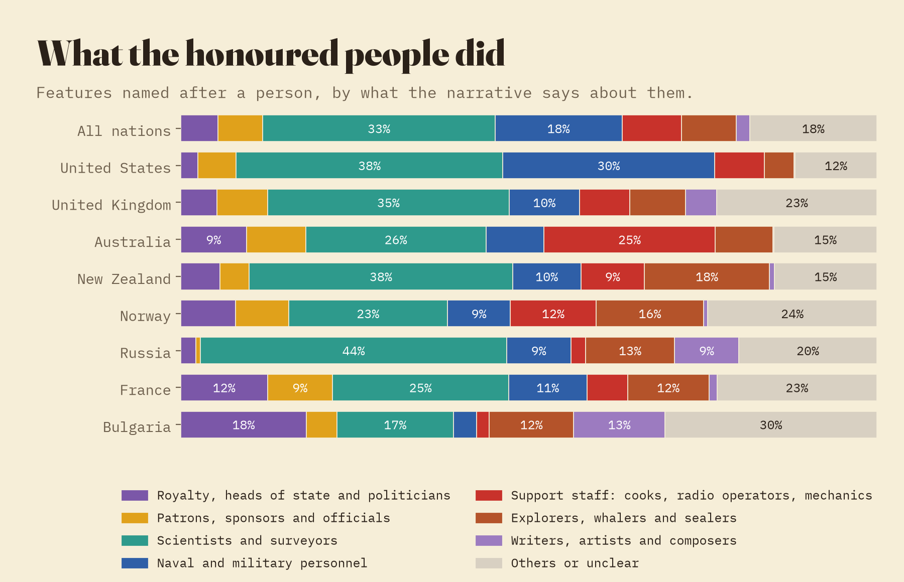
The people on the map are mostly not famous. The commonest surnames among features named after a person are Smith (35), Davis (23), Brown (22), Johnson and Wilson, because the American and British committees honoured the people who did the work. Reading what the gazetteer says about each one, 33% were scientists or surveyors and 18% naval or military personnel. 30% of the people on American names served in the US Navy or another service, many of them aircrew of Operation Deep Freeze, and 25% of the people on Australian names were station staff: cooks, radio officers and weather observers. Bulgaria honours its own history, with tsars, khans, revolutionaries and poets.
Wives, daughters and queens
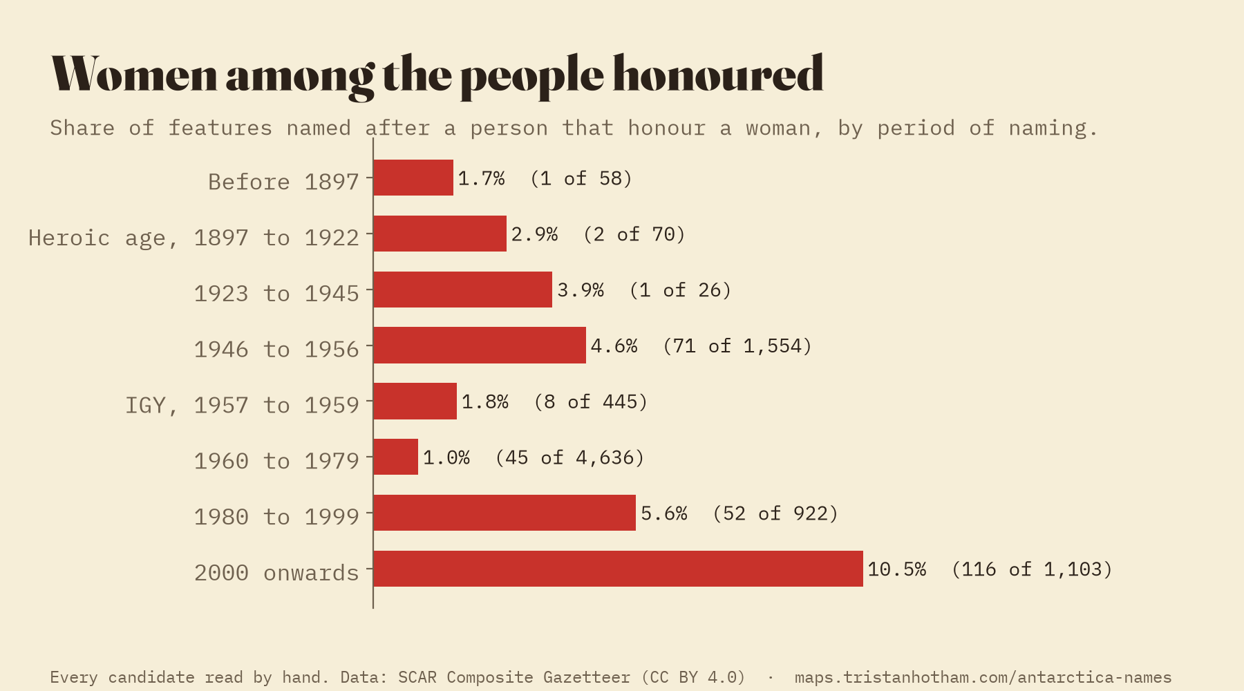
Of the 9,353 features named after a person, 315 honour a woman, 3.4%. Some are among the biggest names on the map: Queen Maud Land, Victoria Land, Marie Byrd Land and the Ronne Ice Shelf. But until recently women were on the map because of whom they were related to. Of the women honoured in names given before 1990, 64% were queens, princesses or the wives, daughters, mothers and sisters of explorers and patrons. That has changed: since 1990 women are 10.3% of the people honoured, against 1.9% before, and most of them are scientists and station staff honoured for their own work, such as the glaciologist Julie Palais and the geologist Margaret Bradshaw. I read every possible case by hand.
Born in Europe
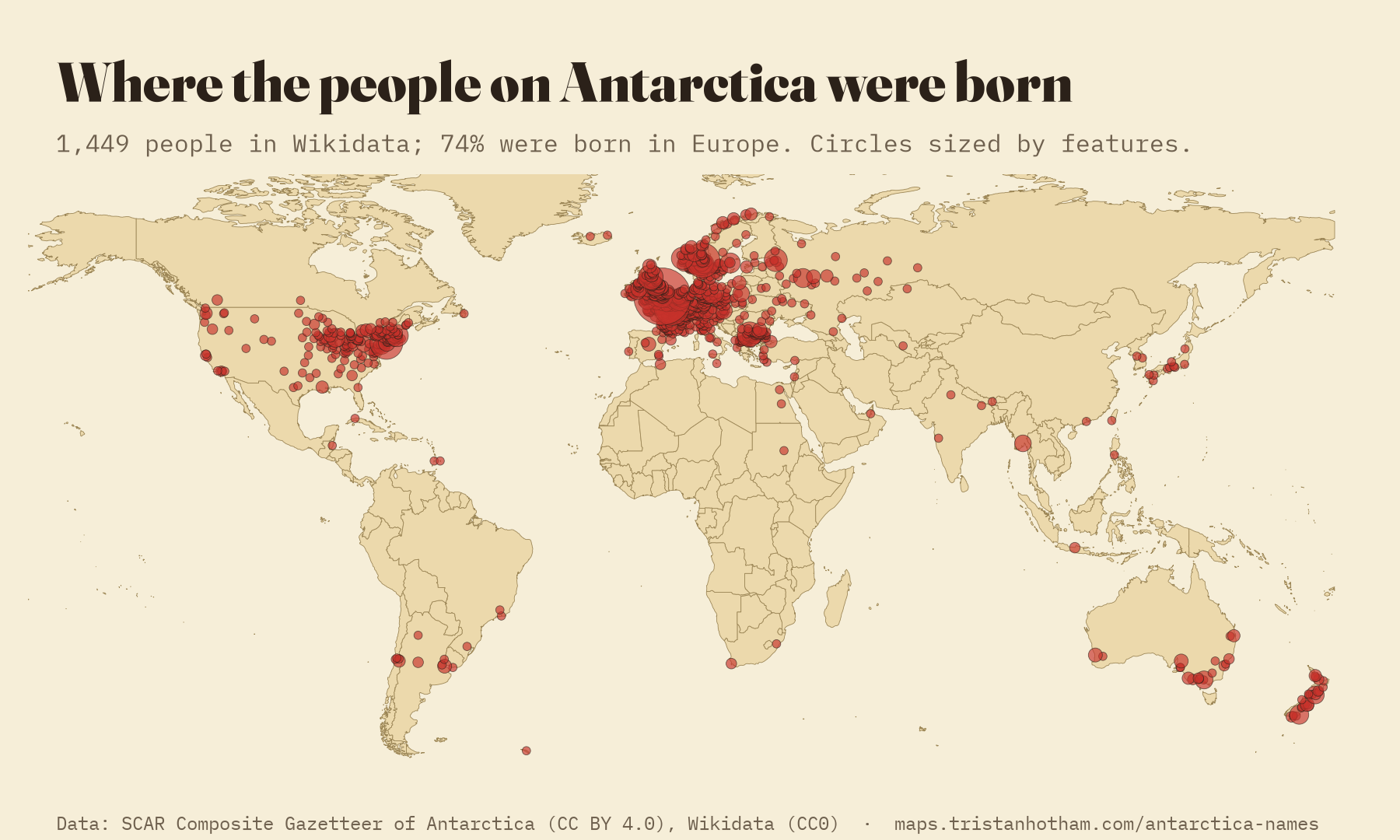
Wikidata links 1,998 Antarctic features to 1,772 people, 1,449 with a known birthplace. 74% were born in Europe and 17% in North America. Africa has 7. Norway mostly honours Norwegians (81% of the people on its names were born in Norway), while Britain looks wider: only 40% of the people on British names were born in the United Kingdom, partly because British surveyors named whole groups of features after foreign scientists, composers and pioneers of photography and flight.
How I did this
The data are the SCAR Composite Gazetteer of Antarctica, from the Australian Antarctic Data Centre, and Wikidata. I grouped the gazetteer’s names by the identifier it uses for the same feature in different national lists, merging 8 duplicates. A set of rules reads each narrative: the words after “named by” give the committee, expedition or leader and so the nation, and the words after “named for” or “named after” give the honoree, sorted into a person, a ship, a place, a description and so on. Where no narrative names the namer, I use the only national list that holds the feature, then the expedition said to have discovered it, then the list that approved it first. I matched Wikidata’s Antarctic features to the gazetteer by name and distance to find the people and their birthplaces.
There are caveats. Many Russian, Argentine and Chinese entries have no narrative in English, so 19% of features have no recorded meaning. Rules misread some narratives: a random audit of 60 features found 7 errors, and a second, independent review corrected 196 more readings (mostly people filed as “other”) and found 106 women the first pass had missed. Some people are still filed as “other”, so the share of people is if anything too low. I read every possible woman by hand, checked the naming nation of every land, coast, sea and ice shelf by eye, and left 21 Wikidata birthplaces off the map because they were only a country or a state. The naming year is often the year a committee approved a name rather than first used it, and 226 British approval dates stored a century early in the source (1901 for 2001) are corrected. Undersea features are left out of the shares of each claim. All corrections are in small documented files with the data.
Notes and sources
- Secretariat SCAR (1992, updated 2014) Composite Gazetteer of Antarctica. Scientific Committee on Antarctic Research. Served by the Australian Antarctic Data Centre (CC BY 4.0).
- Wikidata contributors, Wikidata (CC0), queried with QLever. Vrandečić, D. and Krötzsch, M. (2014) Wikidata: a free collaborative knowledgebase. Communications of the ACM 57(10), 78 to 85.
- Alberts, F. G. (ed.) (1995) Geographic Names of the Antarctic, 2nd edition. US Board on Geographic Names and National Science Foundation, Arlington, VA. The Antarctic Treaty (1959), United Nations Treaty Series 402, 71.
- Coast and ice shelves: OpenStreetMap contributors (ODbL) via OpenFreeMap. Grounded ice and countries: Natural Earth (public domain).
- I wrote the text, with drafting and editing assistance from Claude (Anthropic), which also helped prepare the analysis code. I reviewed and checked all text and results.

