
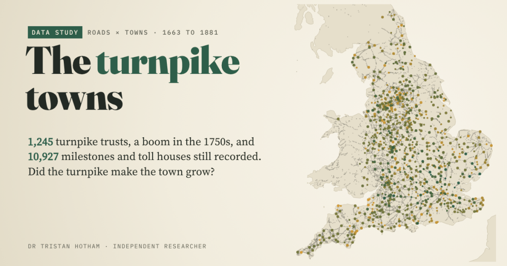
For two centuries England’s main roads were run by turnpike trusts that charged tolls to mend them. I counted 1,245 of the trusts, mapped 10,927 milestones and toll houses that are still recorded, and asked whether the towns on the turnpikes were the ones that grew.
In 1663 Parliament let the justices of three counties put toll gates across the Great North Road at Wadesmill, Caxton and Stilton, and spend the money on the road. It was the first turnpike. Over the next century and a half, road after road was handed to a trust: a group of local worthies who could borrow money, set up gates, charge tolls and pay a surveyor to keep the road in repair. At their peak in the 1830s, over 1,000 trusts ran some 30,000 miles of road in England and Wales.
Those roads carried the coaching age. The first mail coach ran from Bristol to London in 1784, in 16 hours. Telford’s rebuilt Holyhead Road cut the London mail’s journey from 45 hours to 27. Then the railways came, and the story goes that the coaching towns, with their inns and stables and ostlers, emptied. It is the road version of the question I asked about canals and seaside railways: did being on the new transport make a town grow?
Turnpike mania
Wikipedia has eight lists of turnpike trusts, one for each English region, with the year of each trust’s first act. Between them they name 1,245 trusts, 1,119 with a date. (The lists are marked incomplete, the Sussex trusts have no dates, and Wales and Scotland have no dated lists, so this is England only.)
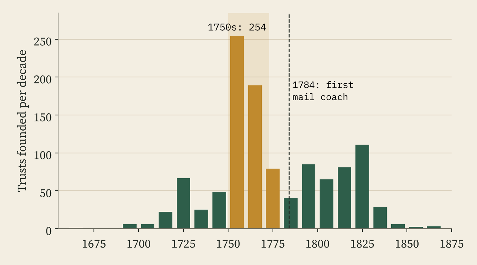
The shape is striking. After a slow start, trust-making exploded in the 1750s: 254 new trusts in ten years. Between 1750 and 1772, 495 trusts were set up, 44% of all those with a date. By 1800 74% existed. After 1830, when the railways began, only 34 more were founded.
I expected a wave rolling out from London. There is one, but it is small. Towns named in trusts within 50 km of London had their first trust in a median year of 1748; towns more than 200 km away, 1759. About a decade. The mania happened almost everywhere at once. Only the North West was clearly late (median 1789), when Lancashire’s mill towns built their own web of roads.
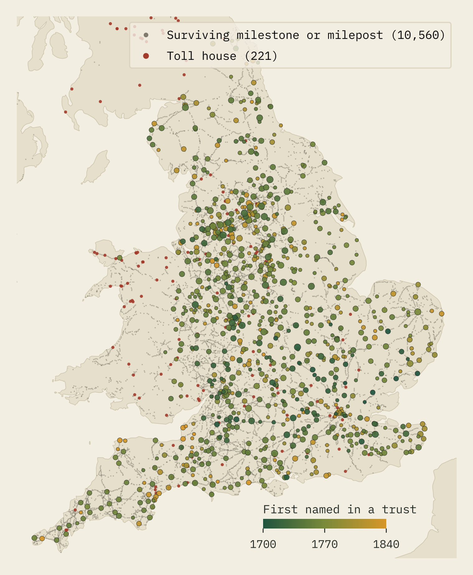
Some towns were the hub of a whole web: Leeds is named in 19 trust titles, Manchester in 15, Birmingham in 11. In all, 1,031 places are named in at least one trust, including 478 of the 1,060 places in England that Ordnance Survey calls a town or city.
What survives on the verges
The trusts had to tell travellers how far they had come, and Wikidata and OpenStreetMap still record 8,214 milestones, 2,346 cast-iron and other mileposts, 146 guide stones and 221 toll houses across the UK. 51% of them stand within 50 m of a modern A-road. The turnpikes simply became our main roads.
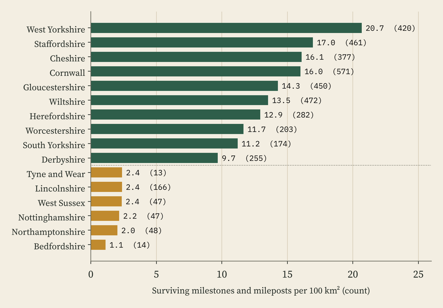
Where they survive is another matter. West Yorkshire has 20.7 recorded milestones per 100 km², Staffordshire 17.0, Cornwall 16.0. Bedfordshire, crossed by some of the very first trusts, has 1.1. That gap is far too big to be about the eighteenth century. It is about what was lost to road widening and decay, and above all about what has been listed and mapped.
Still, the survivors do follow the old routes. 75% of the towns named in a trust have a surviving milestone within 2 km, against 55% of other towns. Milestones are a patchy trace of where the turnpikes ran, but not a count of the roads.
Did the turnpike make the town?
To test growth I need places with census figures from decade to decade. The best set I have is 345 places with figures for 1801, 1831 and 1851, mostly villages, and mostly in Cambridgeshire, Huntingdonshire and the fens (259 of them) and the south west (54), because that is where Wikidata’s editors have entered parish series.
At first glance the turnpike places win. From 1801 to 1831, the places named in a trust grew by a median 1.50% a year; the rest by 1.07%. But the named places were the market towns, and bigger places grew faster everywhere in this period. Allow for size and region and the gap shrinks to 0.10 points a year, with a 95% interval from -0.13 to 0.34. Having a surviving milestone within 1 km makes no difference at all.
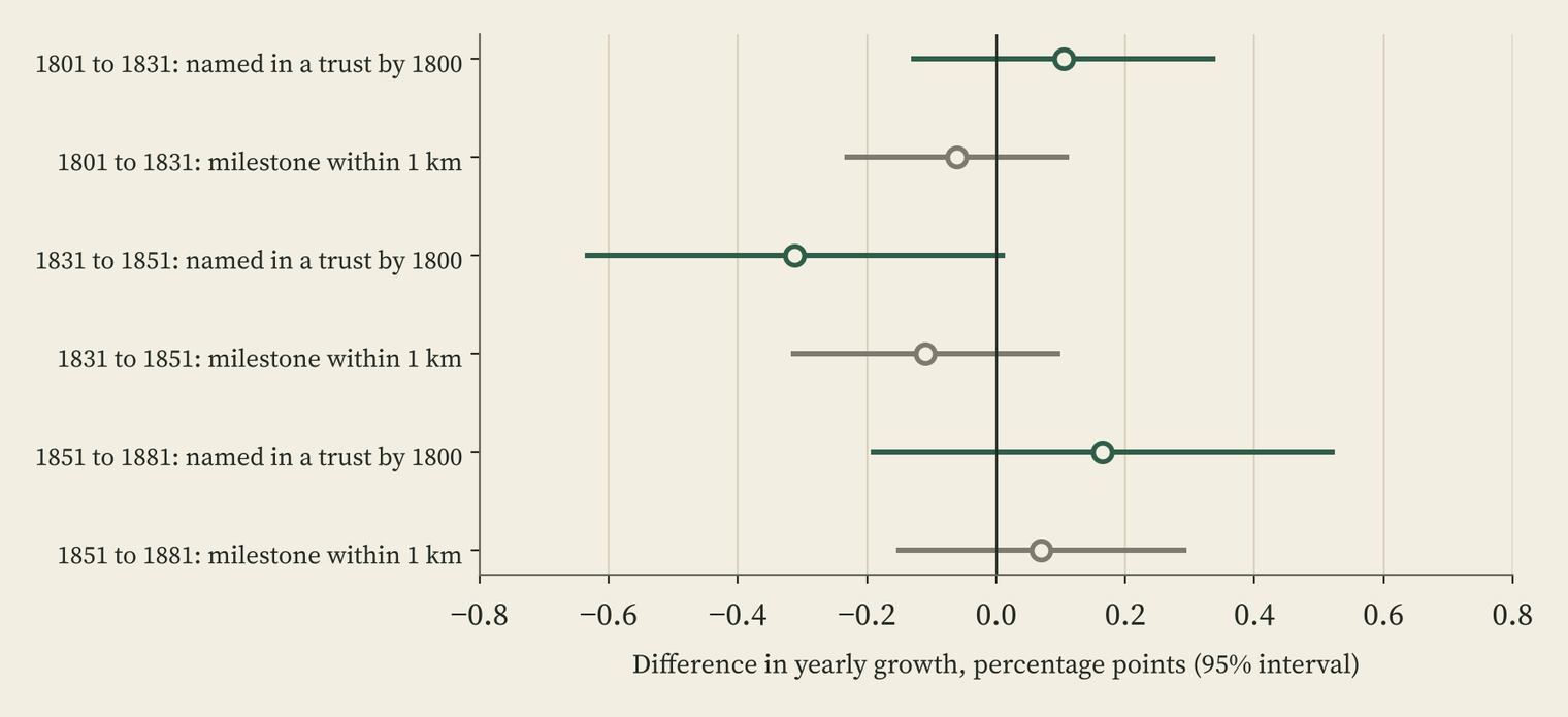
There is a hint of the coaching-town story after 1831. In the first railway decades, 1831 to 1851, the named places grew 0.31 points a year more slowly than comparable places. But the interval runs from -0.63 to 0.01, and it rests on just 28 named places. Suggestive, no more.
Turnpikes reached almost every town within a few decades. When everyone is on the road, being on the road is not much of an advantage.
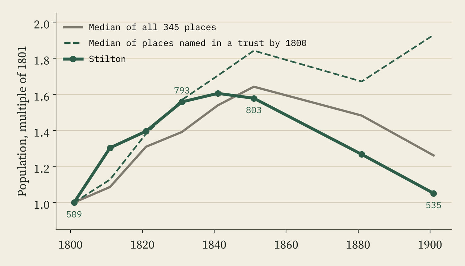
Stilton, on the very first turnpike, is the coaching village of legend. It had 509 people in 1801 and 793 in 1831, stalled at 803 in 1851, and fell to 535 by 1901, back where it started. But most villages in this sample peaked around 1851 and then shrank, as people left the land: 69% of the places never named in a trust were at their biggest in 1851 or earlier. Stilton fell harder than most, which fits the story without proving it.
The big towns tell the same story. 28 of England’s 29 largest towns of 1801 (London aside) are named in a trust, so there is almost nothing to compare. Among them, neither an early trust nor a large number of trusts goes with faster growth to 1861. Big towns attracted turnpikes; there is no sign here that the turnpikes made them big.
How I did this
I took the tables of Wikipedia’s eight regional lists of turnpike trusts. One I had as wikitext; the other seven I read with an automated web reader, and checked it against the wikitext on 82 rows, all of which matched. I split each trust’s name into place names and matched them to OS Open Names, preferring places in the right region. Milestones, mileposts and toll houses come from Wikidata and OpenStreetMap, with duplicates within 40 m removed. Census populations come from Wikidata and A Vision of Britain through Time. Growth is compared with regressions that allow for each place’s size in 1801 and its region.
The big gap is the roads themselves. A full dated map of the turnpike network exists, by Rosevear, Bogart, Shaw-Taylor and Satchell, but I could not get it for this study. Without it, a town only counts as a turnpike town if its name is in a trust’s title. My code is ready to use the map if it becomes available.
Notes and sources
- Turnpike trusts: Wikipedia, Turnpike trust and its regional lists, from Turnpike trusts in South East England to Turnpike trusts in South West England (CC BY-SA 4.0), retrieved 28 October 2026.
- Coaching age: Wikipedia, Mail coach, Tollhouse and Rebecca Riots (CC BY-SA 4.0).
- Milestones and toll houses: Wikidata (CC0) and OpenStreetMap (© OpenStreetMap contributors, ODbL), via QLever.
- Populations: Wikidata and A Vision of Britain through Time (University of Portsmouth). Places: OS Open Names, contains OS data © Crown copyright and database right 2026 (OGL v3).
- Paper, data and code: Zenodo and GitHub. Text and derived data CC BY-SA 4.0; milestone tables ODbL; code MIT.
- I wrote the text, with drafting and editing assistance from Claude (Anthropic), which also helped prepare the analysis code. I reviewed and checked all text and results.

