
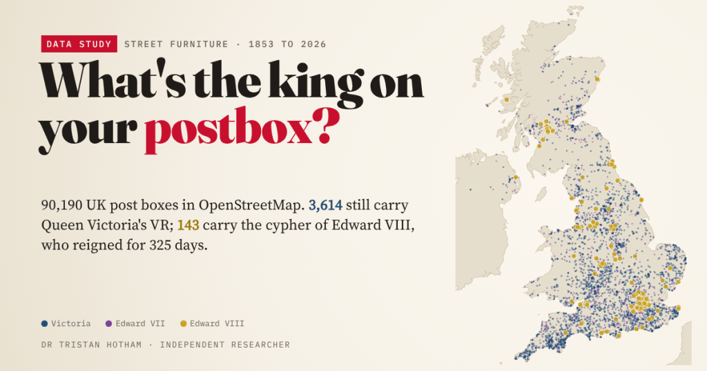
Every British post box carries the cypher of the monarch who reigned when it was made. OpenStreetMap’s volunteers have read 61,435 of them. Here is who is still out on our streets, where the rare ones hide, and how to find the oldest box near you.
Next time you post a letter, look at the door of the box. Just below the slot there are usually a few letters under a crown. VR is Victoria Regina. GR is George V. EIIR is Elizabeth II. A box keeps the cypher of the reign in which it was cast, so every street is a small, accidental museum: a Victorian wall box in a village lane, a George V pillar outside a parade of 1920s shops, a shiny Charles III box on a new estate.
OpenStreetMap, the free map that volunteers build, records post boxes, and on many of them someone has walked up and noted the cypher. On 28 October 2026 it held 90,190 boxes in the United Kingdom, about 78% of the 115,000 or so that Royal Mail counted in 2002, and 61,435 of them had a cypher recorded. That is enough to ask some questions I have always wondered about on walks.
Seven monarchs and a crown
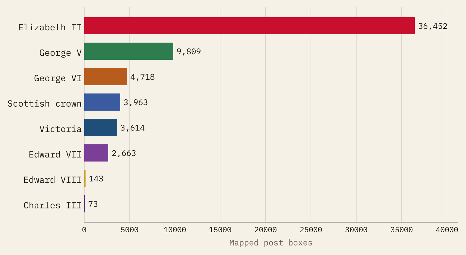
Elizabeth II wins by a distance. Her EIIR is on 36,452 mapped boxes, 59% of those with a cypher. She reigned for seventy years, through the decades when the network grew most, and every box replaced in that time got her cypher. George V comes second with 9,809, then George VI, Scotland’s crown, Victoria with 3,614 and Edward VII. Charles III has 73 so far.
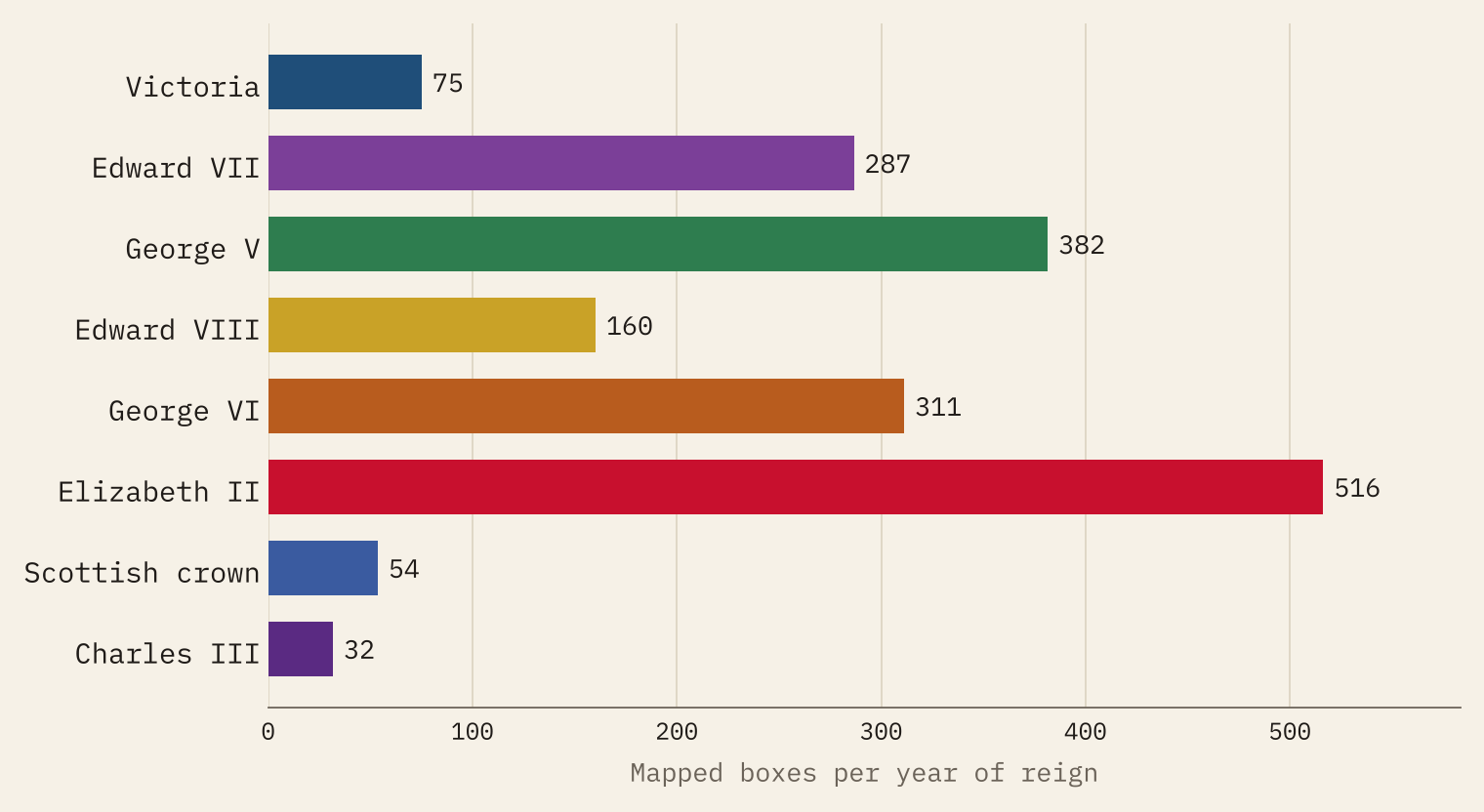
Long reigns pile up boxes, so I also divided each reign’s boxes by the years in which they could have been made. Victoria had 48 years of boxes, from the first one in mainland Britain at Carlisle in 1853, but only 75 survive for each of those years, against 516 a year for Elizabeth II. Fewer boxes were made in the 1860s, and a box that has stood for well over a century has had plenty of chances to be hit by a lorry or swapped for a new one.
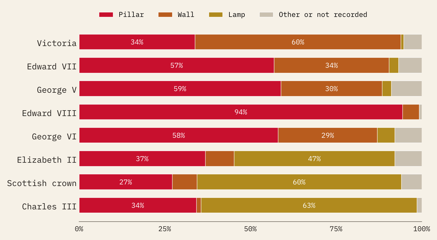
The Victorians who did survive mostly hid in walls. 2,173 of the 3,614 VR boxes are wall boxes, where nothing could knock them over. The little lamp boxes bolted to posts belong to the later reigns: 17,073 of the 25,061 mapped lamp boxes are Elizabeth II’s.
The Edward VIII hunt
The prize for postbox spotters is EVIIIR. Edward VIII came to the throne on 20 January 1936 and abdicated on 11 December, before his coronation. A Historic Environment Scotland listing for one of his boxes in Glasgow says that 271 letter boxes were made in 1936, 161 of them pillar boxes, and that the Letter Box Study Group has found 171 survivors. After the abdication most of his wall and lamp boxes were given George VI doors, while the pillar boxes mostly kept theirs.
OpenStreetMap has 143 EVIIIR boxes, 84% of those 171, and 135 of them are pillar boxes, just as the door story predicts. Greater London has 26 and Glasgow 15. Per year of reign, Edward VIII has left 160 boxes: more than twice Victoria’s rate.
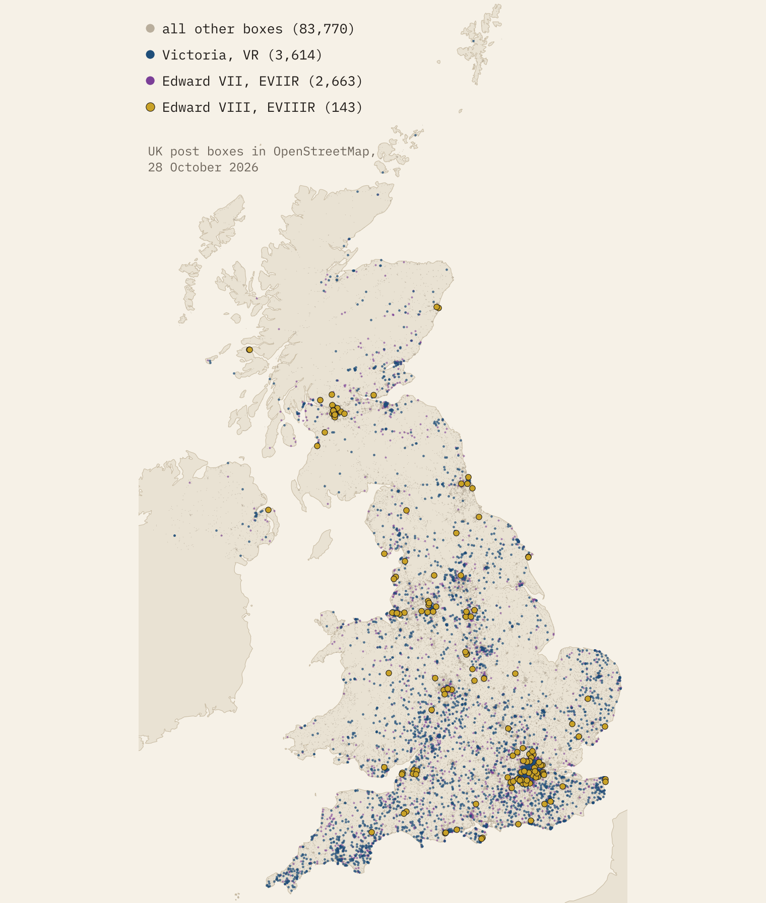
The map knows some famous Victorians too. Wikipedia says the oldest pillar boxes still used by Royal Mail are a pair at Framlingham in Suffolk, cast in Derby in 1856; OpenStreetMap has two octagonal VR pillar boxes within a kilometre of the town centre. It also has 82 hexagonal Penfold boxes, the ornate design of 1866 to 1879, of which about 150 are said to survive.
Scotland’s crown
In 1952 the first EIIR boxes in Scotland met angry objections: there had never been an Elizabeth I of Scotland. A new pillar box in the Inch district of Edinburgh was tarred, hammered and finally blown up. The Post Office gave way, and new Scottish boxes carried the Crown of Scotland instead. Seventy years on, the map shows how complete that settlement was: 3,933 Scottish boxes with the crown, and just 39 with EIIR, most of them small lamp boxes.
3,933 Scottish crown boxes, 39 with EIIR: the Pillar Box War is still visible on the map.
Is your town Victorian?
If boxes keep the cypher of the year they were made, the mix on a town’s streets ought to say something about when the town was built. So I put each box into its 2022 built-up area and kept the 131 towns and districts with at least 50 boxes with a cypher.
The oldest mixes are in inner London: in the City of London 48% of the boxes are Victorian or Edwardian, and in Hammersmith and Fulham, Haringey, Wandsworth and Camden about two in five. Outside London, Manchester, Royal Tunbridge Wells, Bournemouth and Cheltenham lead. At the other end are the post-war new towns: Glenrothes, Stevenage, Crawley, Milton Keynes and Livingston each have two pre-1910 boxes or fewer.
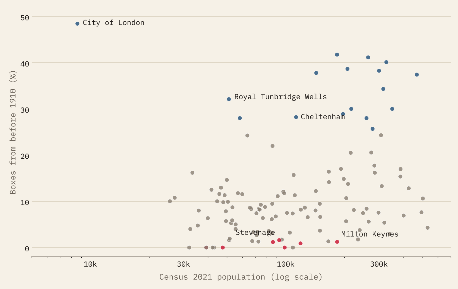
It is a rough clock, though. Old towns such as Chichester, Newbury and Chelmsford also look young, because boxes get replaced. A better test uses the population in 1911. For 16 towns where I had a 1911 census figure, the more of today’s population was already there in 1911, the more Victorian and Edwardian boxes survive (a rank correlation of 0.63). Bournemouth, Margate and Scarborough keep plenty; Aylesbury and Bognor Regis, more than seven times bigger than in 1911, have almost none. Sixteen towns is a small sample, so I take it as a promising sign rather than proof.
The map, not the boxes
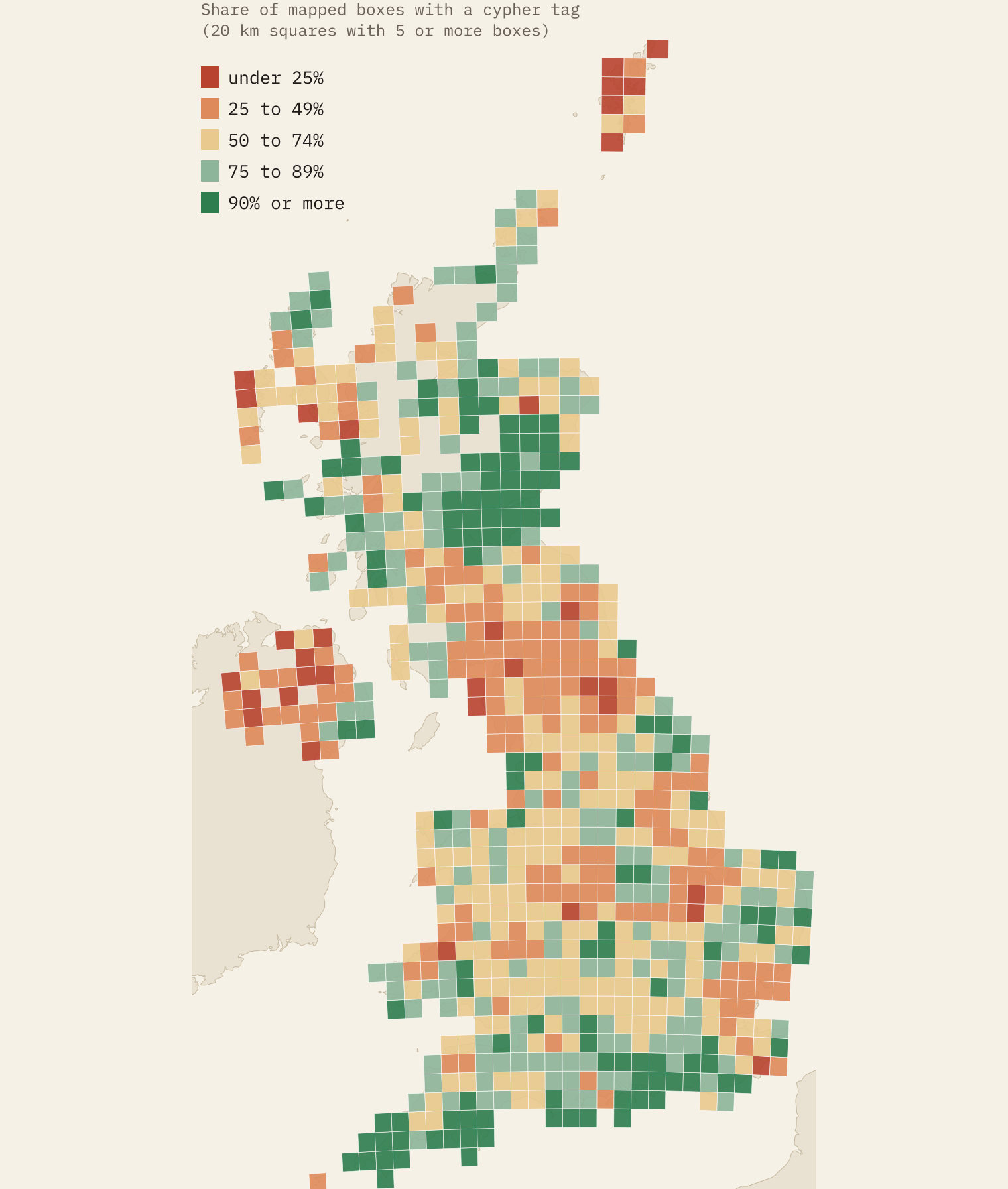
All of this counts the boxes that volunteers have mapped and tagged. 27,168 mapped boxes (30%) have no cypher recorded, and the share tagged runs from 30% in County Durham to 100% on the Wirral. I worried that mappers might note the cypher on an interesting old box and skip a plain new one, but the data say not: where at least 90% of boxes are tagged, Victorian boxes make up 5.1% of the total, a little less than the 5.9% overall.
How I did this
I took every OpenStreetMap object tagged as a post box inside the United Kingdom, through the QLever query service, and read its royal_cypher tag (VR, EVIIR, GR, EVIIIR, GVIR, EIIR, CIIIR or scottish_crown), its box type and its design. Counties and nations come from the nearest place in OS Open Names. For towns I placed each box in the nearest 2022 built-up area, using its centroid and size, and used Census 2021 populations. A cypher dates the casting of a box or its door, not the day it went up: boxes are moved, doors are swapped and replicas copy old cyphers, and Victorian “anonymous” boxes of 1879 to 1887 have no cypher at all.
The interactive version has a map of every box and a “find yours” search: type a town or postcode and it lists the nearest box of each reign. If the cypher on your local box is missing or wrong in OpenStreetMap, you can fix it, and the map will be better for the next person.
Notes and sources
- Post boxes: © OpenStreetMap contributors, Open Database Licence 1.0, retrieved 28 October 2026 through QLever.
- Places: OS Open Names, contains OS data © Crown copyright and database right 2026 (Open Government Licence v3.0). Built-up areas and Census 2021: Office for National Statistics (Open Government Licence v3.0).
- History: Wikipedia, Pillar box, Post box, Royal cypher and Pillar Box War (CC BY-SA 4.0). Edward VIII figures: Historic Environment Scotland, listing LB52465.
- Cross-check: Wikidata (CC0). 1911 populations: A Vision of Britain through Time, via my study Did the railway invent the seaside?
- The data files derived from OpenStreetMap are released under the ODbL 1.0; the text and figures are CC BY 4.0, and the code is MIT.
- I wrote the text, with drafting and editing assistance from Claude (Anthropic), which also helped prepare the analysis code. I reviewed and checked all text and results.

