
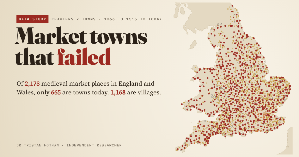
Between the Norman Conquest and 1516, English kings licensed markets in their thousands, each one a bet that a village would become a town. I followed all 2,173 medieval market places in England and Wales to today. Fewer than a third are towns. Most are villages, and a few are fields or sea.
In 1251 a market was granted at Ravenserodd, a port on the sandbanks at the mouth of the Humber. It was a borough, with two markets and a fair on record. The sea took it in the fourteenth century, and today there is no named settlement within 1.5 km of where it stood.
Ravenserodd is the dramatic case. The ordinary case is quieter: a village with a church, a pub and a charter in the rolls saying that, seven or eight hundred years ago, its lord was allowed to hold a market there every Tuesday. Most of England’s medieval markets ended up like that. This post is about how many, and why some places made it when others did not.
My source is Samantha Letters’s Online Gazetteer of Markets and Fairs in England and Wales to 1516, a superb piece of scholarship that lists, county by county, every market and fair with evidence before 1516. I turned it into numbers: 2,411 places, 2,590 markets and 2,936 fairs, each place with a grid reference, the kind of evidence (royal charter, other grant, or custom) and the first year a market is recorded. Then I looked every place up on today’s map. This is the third of my “is it destiny?” studies, after Domesday Destiny and Minted.
A boom, then the Black Death
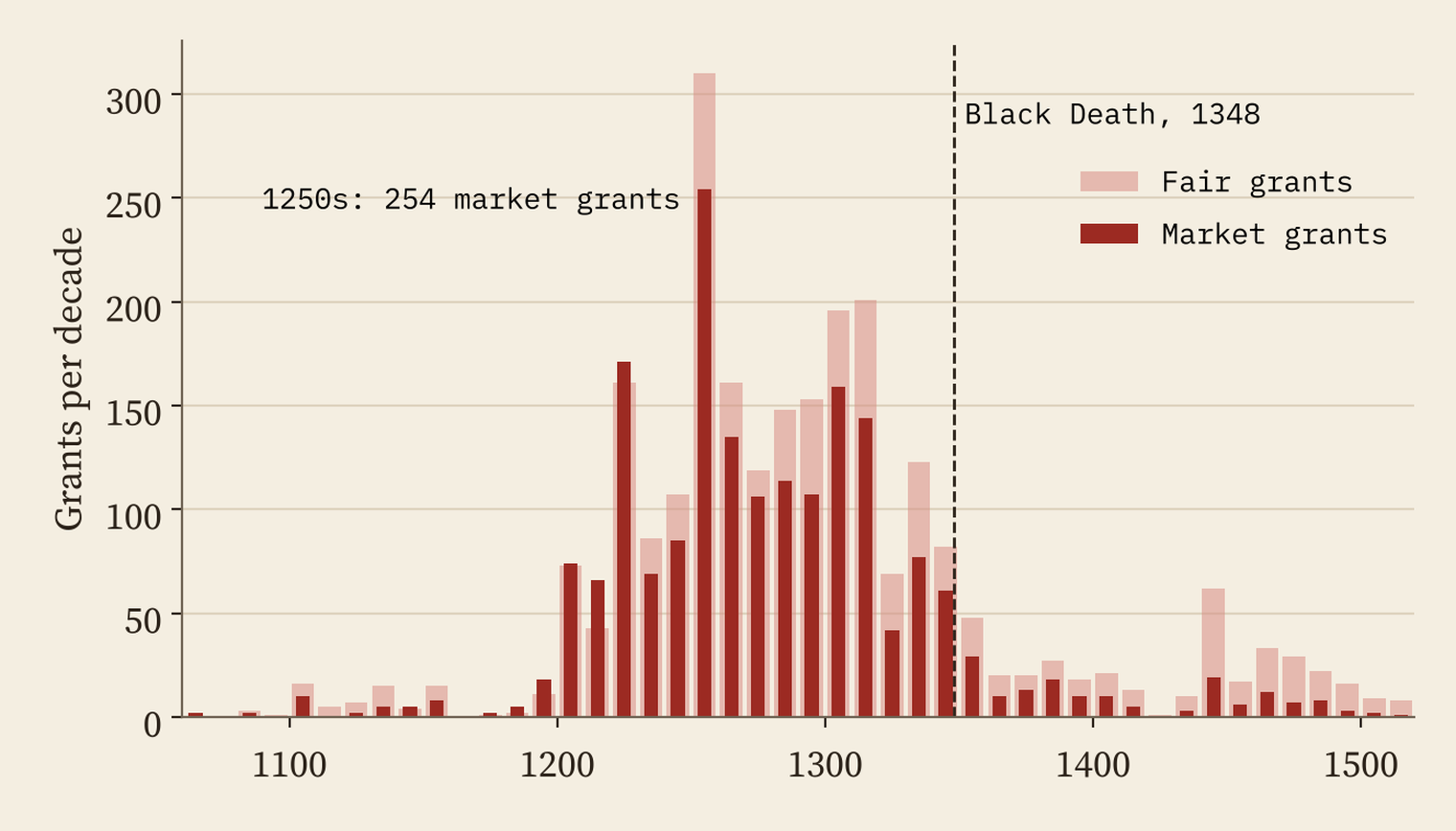
The Gazetteer records 1,879 royal grants of a market, 1,549 of them by charter. 88% fall between 1200 and 1348. The busiest decade was the 1250s, with 254 market grants. Then plague arrived in 1348, and the boom ended almost overnight: 61 grants in the 1340s, 29 in the 1350s, and an average of under ten a decade for the rest of the period.
What they are now
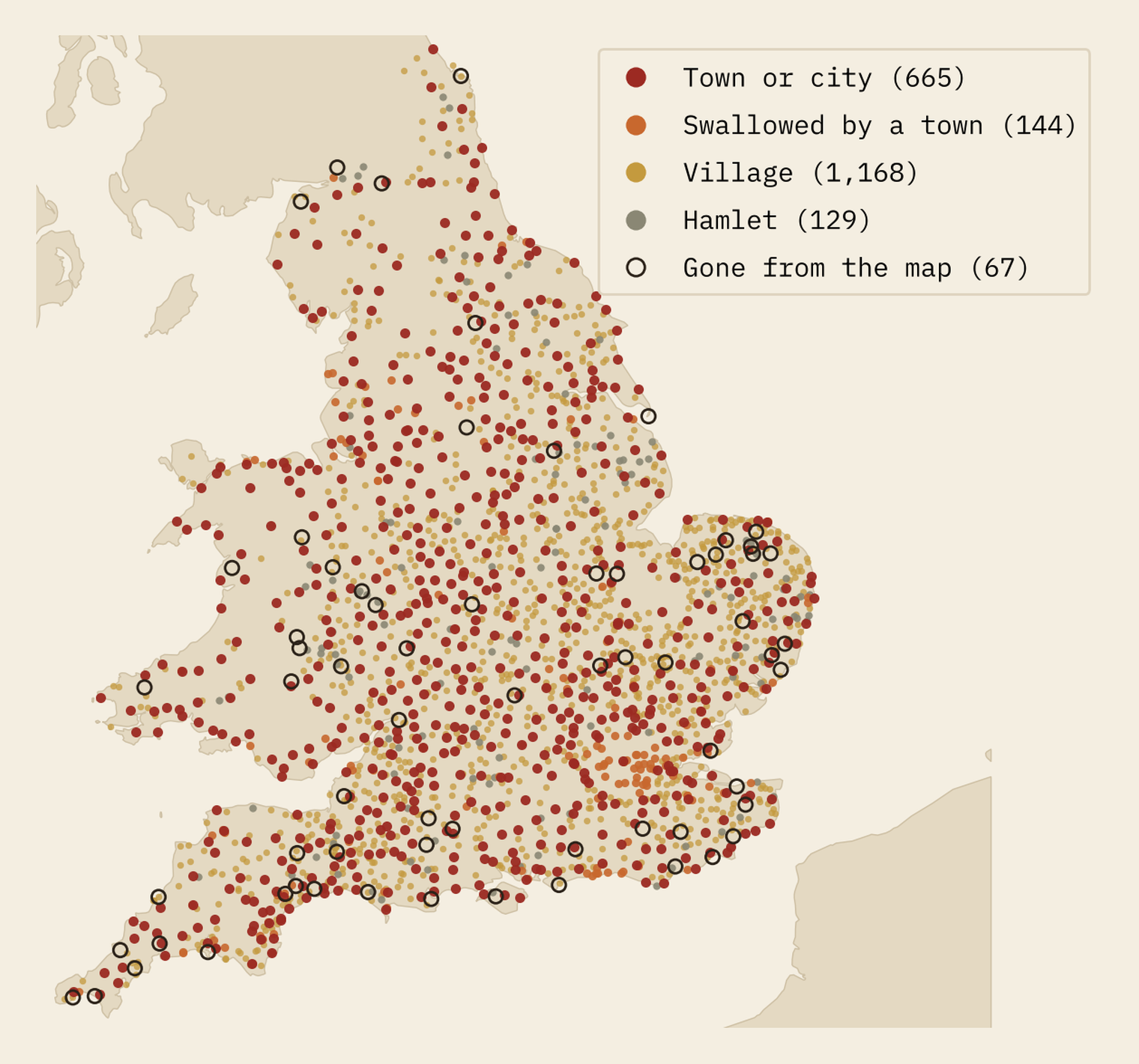
To find out what each place is today I matched it to Ordnance Survey’s open gazetteer of place names, which classes every settlement as a city, town, village, hamlet or suburb, and checked the borderline cases against Census 2021 built-up areas. Of 2,173 market places, 665 (31%) are towns or cities. Another 144 have been swallowed by a bigger town, like Croydon or Kingston upon Thames in London. 1,168 (54%) are villages, 129 are hamlets and 67 have gone from the map altogether.
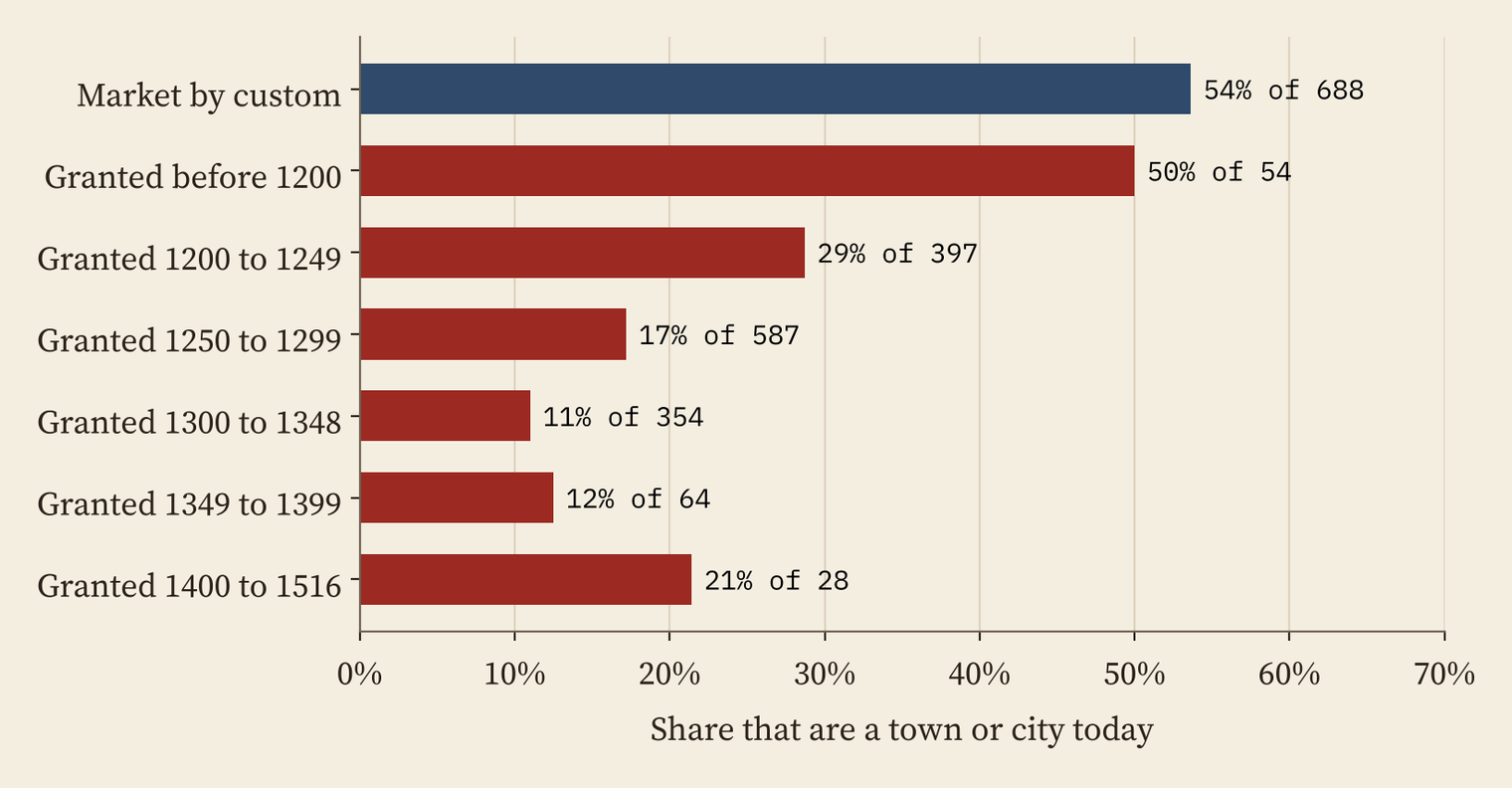
When a place got its market mattered a lot. Places with a market by custom, usually old Anglo-Saxon or Norman boroughs, did best: 54% are towns today. For places whose first market was a royal grant, the odds fall with every half century: 29% for grants in 1200 to 1249, 17% in 1250 to 1299 and just 11% in 1300 to 1348.
A third of a day’s walk
Why did the late markets fail? Mostly because they were squeezed in. The thirteenth-century law book known as Bracton says a reasonable day’s journey is twenty miles, split into three: the morning to walk to market, the middle to buy and sell, and the evening to walk home. A new market within a third of that, six and two-thirds miles or about 10.7 km, could be challenged as a nuisance by an older one.
The rule did not stop the Crown. Of 1,484 places whose first market was a grant, 82% lay within 10.7 km of a market already on record; the median gap was 5.8 km. But the squeezed-in markets rarely grew: 15% are towns today, against 41% of the ones with room around them.
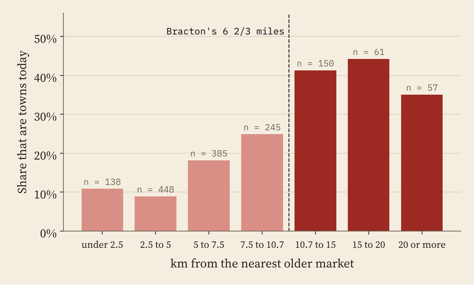
A market charter was a licence to try, not a promise. The winners were mostly the places that were already central before the boom began.
What made a winner
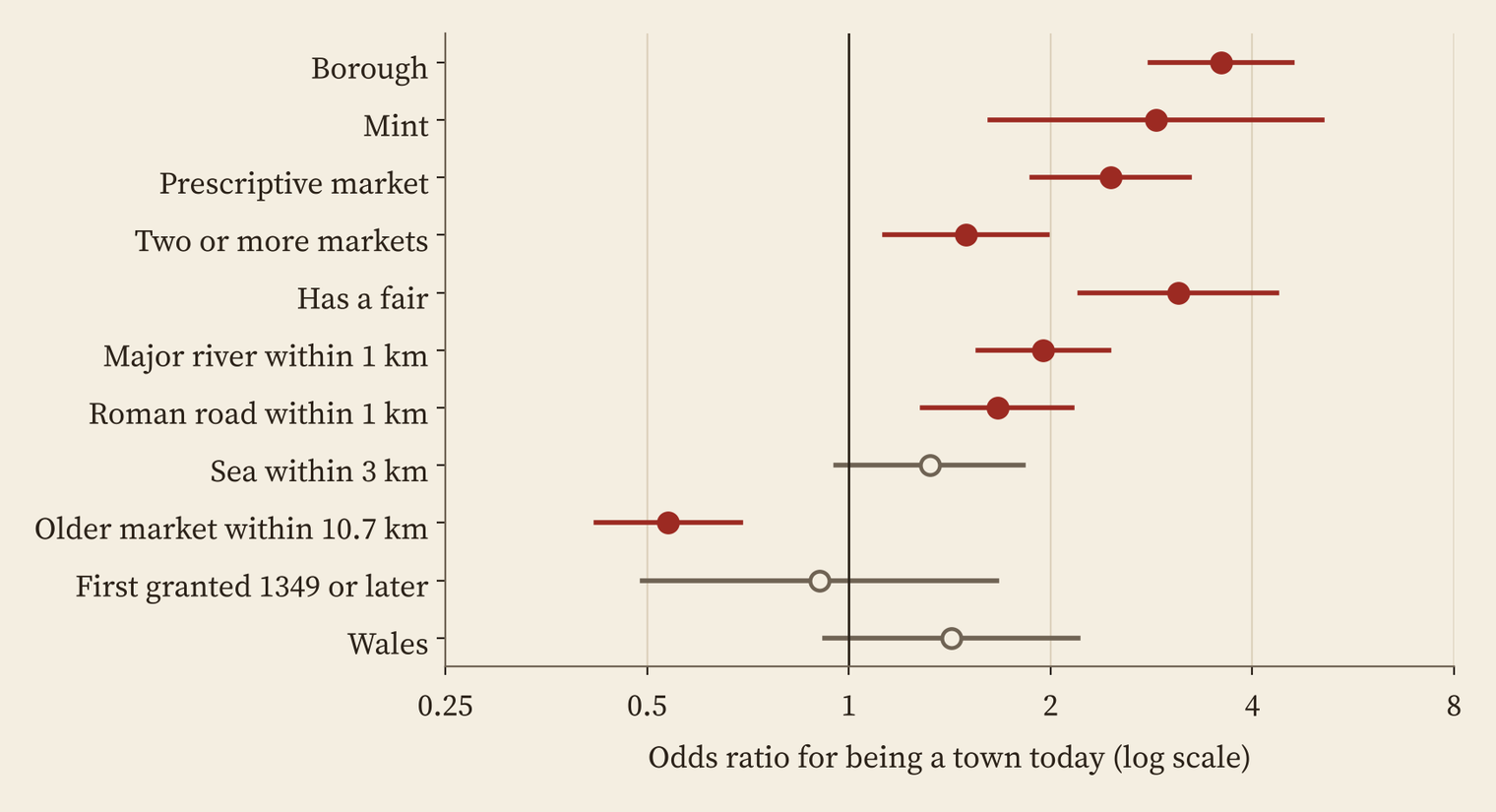
Put everything into one model and a clear picture emerges. Being a borough multiplies the odds of being a town today by about 3.6. A mint, a market by custom, a fair, a major river within a kilometre and a Roman road all help too. An older market within Bracton’s distance roughly halves the odds. Size in Domesday Book helps only at the very top: 53% of market places with 100 or more households in 1086 are towns today, but below that size made little difference.
Decided by 1600
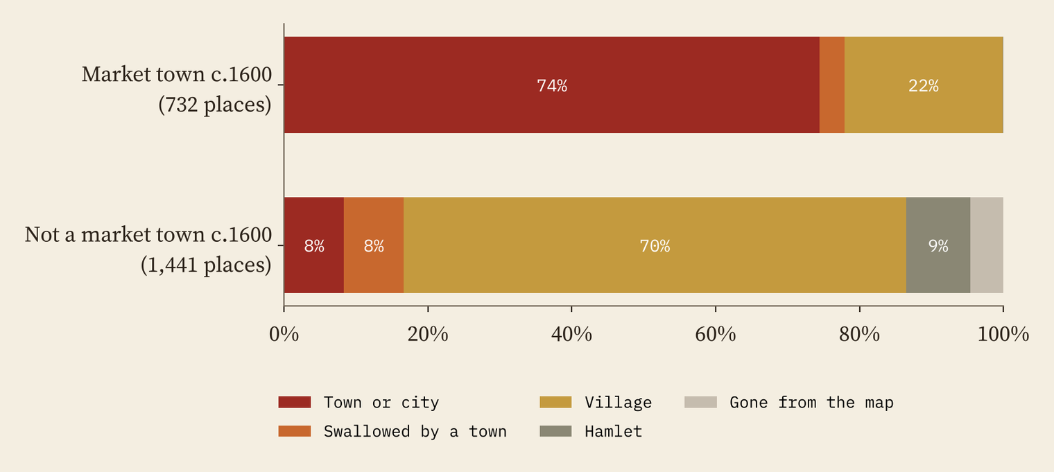
The Gazetteer also flags the places on Alan Everitt’s list of market towns around 1600, which gives a halfway check. 732 medieval market places were still market towns then, and 74% of them are towns today. Of the 1,441 that had already dropped out, only 8% are. Most of the sorting had happened by the time of Elizabeth I. A few fell later: Lavenham in Suffolk, a market town around 1600, is a village of 1,922 people now.
The ones that came to nothing
The saddest list is the 30 boroughs, places granted urban privileges, that are now hamlets or nothing at all. Ravenserodd and Old Winchelsea were lost to the sea. Old Sarum was abandoned for Salisbury. Castell y Bere, Dinefwr and Dryslwyn in Wales were small boroughs beside castles. Torksey on the Trent had 264 households in Domesday Book and a borough; its parish has 777 residents today. You can find all of them, and look up any place near you, on the interactive map.
How I did this
I parsed the Gazetteer’s county pages into derived variables only: counts, years, kinds of evidence, flags and converted coordinates, not its text. Its grid references are in hectometres on the National Grid; I converted them and checked 16 well-known places, all within 1 km of the town of that name, and corrected 7 clearly mistyped references. Places were matched to OS Open Names by name within 4 km (96% found), populations come from Census 2021 built-up areas, and Domesday households from the Hull Domesday Project. “Town” here means what Ordnance Survey calls a town or city today, which is a cartographic label rather than a legal one, and a grant is not proof a market was ever held. Everything here is association, not cause.
Notes and sources
- Markets and fairs: Samantha Letters, Online Gazetteer of Markets and Fairs in England and Wales to 1516 <http://www.history.ac.uk/cmh/gaz/gazweb2.html>: Bedfordshire (last updated 27 February 2007); Berkshire (last updated 17 November 2006); Buckinghamshire (last updated 23 February 2005); Cambridgeshire (last updated 23 February 2005); Cheshire (last updated 12 April 2010); Cornwall (last updated 17 November 2006); Cumberland (last updated 17 November 2006); Derbyshire (last updated 26 February 2007); Devon (last updated 14 July 2010); Dorset (last updated 23 July 2007); County Durham (last updated 15 July 2010); Essex (last updated 16 November 2006); Gloucestershire (last updated 15 July 2010); Hampshire (last updated 17 November 2006); Herefordshire (last updated 23 February 2005); Hertfordshire (last updated 23 February 2005); Huntingdonshire (last updated 17 November 2006); Kent (last updated 26 February 2007); Lancashire (last updated 14 July 2010); Leicestershire (last updated 23 February 2005); Lincolnshire (last updated 17 November 2006); Middlesex (last updated 23 February 2005); Norfolk (last updated 17 November 2006); Northamptonshire (last updated 14 July 2010); Northumberland (last updated 23 February 2005); Nottinghamshire (last updated 14 July 2010); Oxfordshire (last updated 23 February 2005); Rutland (last updated 17 November 2006); Shropshire (last updated 14 July 2010); Somerset (last updated 14 July 2010); Staffordshire (last updated 17 November 2006); Suffolk (last updated 17 November 2006); Surrey (last updated 17 November 2006); Sussex (last updated 17 November 2006); Warwickshire (last updated 16 March 2007); Westmorland (last updated 23 February 2005); Wiltshire (last updated 17 November 2006); Worcestershire (last updated 15 July 2010); Yorkshire (last updated 14 July 2010); Wales (last updated 16 March 2007). Now at archives.history.ac.uk/gazetteer. The Gazetteer is copyright; only derived variables are used and republished.
- Bracton: Bracton on the Laws and Customs of England, translated by S.E. Thorne, vol. 3, p. 198 (Ames Foundation, Harvard Law School Library). Market towns around 1600: A. Everitt’s list in The Agrarian History of England and Wales, vol. IV (1967), as flagged in the Gazetteer.
- Places: OS Open Names and OS Open Rivers, contains OS data © Crown copyright and database right 2026, Open Government Licence v3.0. Census 2021 and geography: Office for National Statistics, Open Government Licence v3.0.
- Domesday: Hull Domesday Project (CC BY-NC-SA), via Domesday Destiny. Roman roads: Itiner-e (CC BY 4.0). Coastline: Natural Earth.
- Paper, data and code: Zenodo and GitHub.
- I wrote the text, with drafting and editing assistance from Claude (Anthropic), which also helped prepare the analysis code. I reviewed and checked all text and results.

