
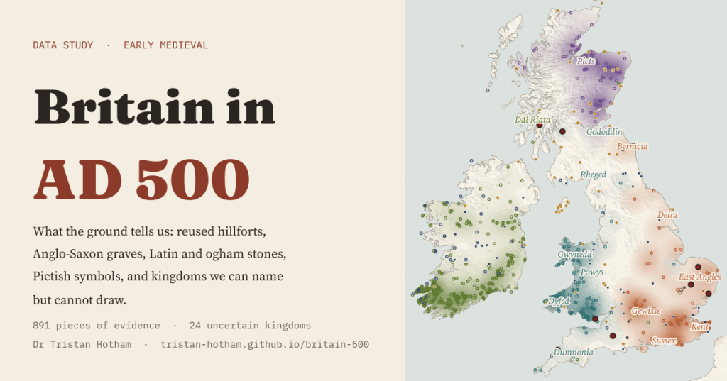
Maps of Britain in AD 500 show neat kingdoms with borders. Almost nothing written at the time survives. So I mapped what the ground can actually place: 891 pieces of evidence, and 24 kingdoms we can name but cannot draw.
You have probably seen one of those maps: Britain around AD 500 as a patchwork of kingdoms, Gododdin and Rheged in the north, Gwynedd and Dumnonia in the west, Kent, Sussex and the East Angles in the east, each in its own colour. I love them. But they hide an awkward fact. Gildas, a British monk, is the only writer of any length close to the time, and even his book could date from anywhere between the late 400s and the 540s. Bede wrote in 731. Most of the kingdom names reach us through texts written centuries later.
So I tried the other way round. I started with what archaeology and the national records can place on a map: hillforts that people went back to, Anglo-Saxon cemeteries, memorial stones carved in Latin and in the Irish ogham alphabet, Pictish symbol stones and early churches. Only then did I lay the kingdom names on top, as faint zones with a note on where each name is first written down.
What the ground can place
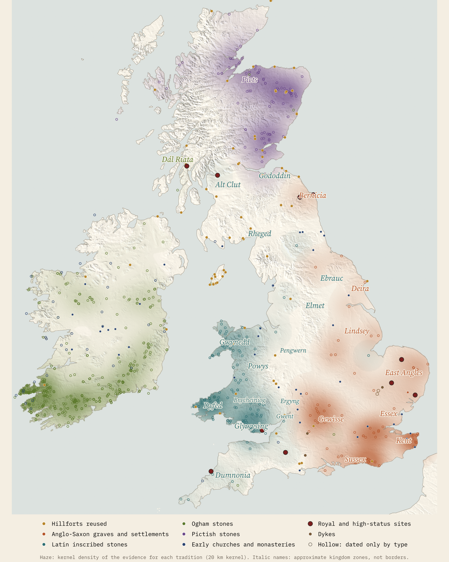
The map holds 402 ogham find-spots, 139 Latin inscribed stones, 90 Pictish stones, 87 hillforts with dating evidence for AD 400 to 800, 74 early churches and monasteries and 70 Anglo-Saxon cemeteries and settlements, plus a short list of famous high-status sites and dykes. That is uneven, and I will come back to why. But a few patterns come through loud and clear.
Graves in the east, stones in the west
Put the Anglo-Saxon cemeteries next to the inscribed stones and Britain splits in two. The Anglo-Saxon sites have a median longitude of 0.05 degrees west, almost on the Greenwich meridian. The stones and the western high-status sites sit at 4.09 degrees west, in the middle of Wales. Of 143 western sites, just 1 has an Anglo-Saxon site within 50 km.
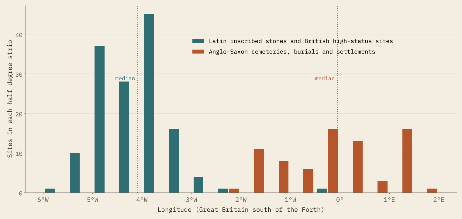
It is worth being careful about what this shows. It is a map of two habits, not two peoples. In the east, people buried their dead with brooches, beads and weapons, or cremated them in urns. In the west, Christian Britons raised memorial stones with Latin names. A farmer in Kent who never owned a brooch, or a family in Wales too poor for a stone, is invisible here. The records are uneven too: Wikidata knows only 70 Anglo-Saxon cemeteries and settlements that I could identify, far fewer than archaeologists have found.
Back to the hillforts, by the sea
The Atlas of Hillforts of Britain and Ireland records 4,147 hillforts. Just 87 (2.1%) have dating evidence for use between AD 400 and 800. 48 of them are in Scotland, and on the Isle of Man the share is a striking 47%.
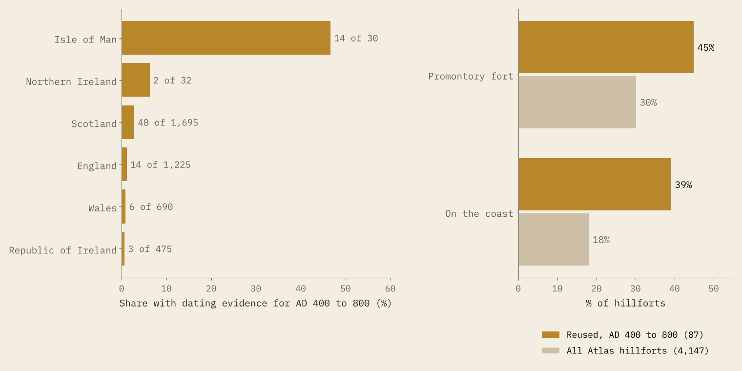
The reused forts are not typical. 39% are on the coast, against 18% of all hillforts, and 45% are promontory forts, against 30%. That fits the famous excavated sites: Tintagel on its Cornish headland, where a palace of the 5th or early 6th century has been traced; Dunadd in Argyll; Dumbarton Rock on the Clyde, whose king Saint Patrick wrote to. Small, defended seats by the sea, where goods from the Mediterranean came ashore. It could also partly be that coastal sites have simply been dug more often.
Across the Irish Sea
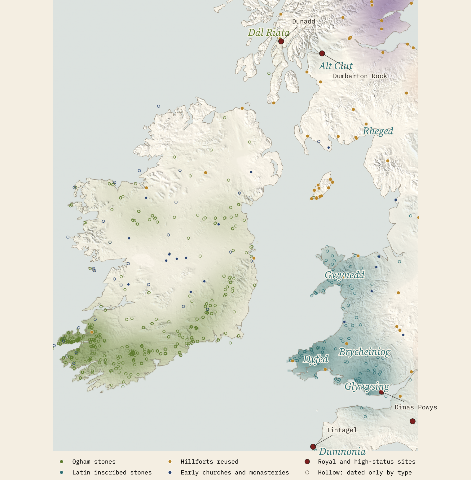
Ogham is an alphabet of strokes and notches cut along the edge of a stone, used mainly for early Irish. 97% of my 402 ogham find-spots are in Ireland. Wikipedia says the largest group outside Ireland is in Pembrokeshire, but my data misses it, because Wikidata records most Welsh stones simply as “inscribed stones”. Even so, 49 of the 139 inscribed stones are in the old county of Dyfed in the south-west.
The written sources point the same way. Dyfed’s royal line is said to have been founded by Irish settlers in the 5th century. A stone from Castell Dwyran of about 550 names a king in Latin and in ogham and calls him by the late Roman title of protector. He is often identified with Vortipor, a king Gildas attacks by name, though the spellings differ and not everyone agrees.
One stone, two alphabets, and perhaps a king who appears in Gildas.
Names without borders
I placed 24 kingdoms on the map, 14 British, 8 Anglo-Saxon, one Gaelic and one Pictish, each at the area its Wikipedia article points to, and counted the evidence nearby. In the south and east the zones for Kent, Sussex and the East Angles are full of Anglo-Saxon evidence; in Wales, Gwynedd and Dyfed are full of inscribed stones. In the north it falls apart. The zone I drew for Gododdin, around Edinburgh and Traprain Law, holds Pictish stones from across the Forth and hillforts with no cultural label. Elmet and Ergyng, known from texts and place-names, hold almost nothing my layers can see.
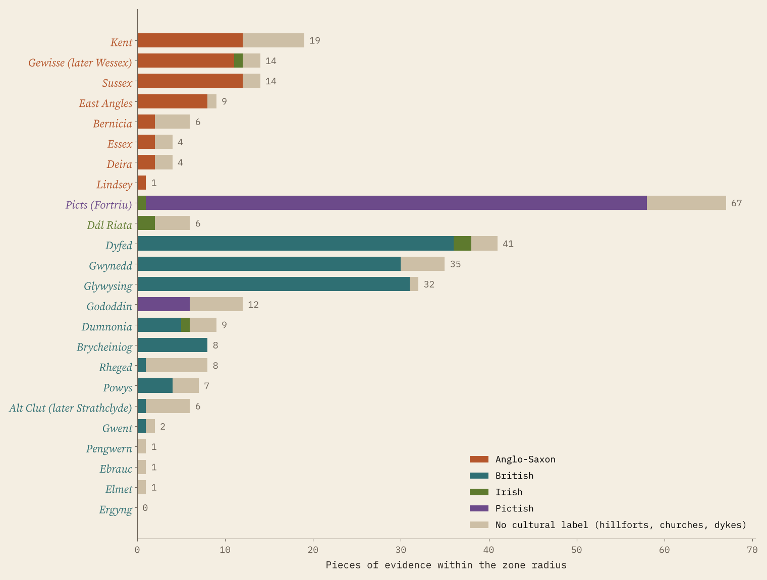
Why so thin? Because nearly everything we know by name was written down long afterwards. Bede finished his history in 731. The Historia Brittonum is of the early 9th century. The Anglo-Saxon Chronicle survives in manuscripts of the 9th to the 12th centuries, and the poem Y Gododdin in a single manuscript of the later 13th century.
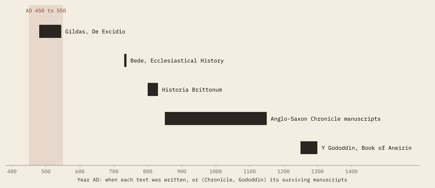
The mid 6th century had its own disasters, a volcanic cooling from 536 and the plague of Justinian, which burials at Edix Hill near Cambridge show reached Britain. Neither shows on my map: the dating of most of this evidence is far too broad. The names are real; they mattered to the people who wrote them down. But the ground, mute as it is, is the only witness from the time.
How I did this
Hillforts come from the Atlas of Hillforts of Britain and Ireland (Lock and Ralston 2017), keeping those it marks with dating evidence for AD 400 to 800. Everything else comes from 102,712 Wikidata items filtered hard by type and wording, the ogham stones in Ireland’s Sites and Monuments Record, Roman towns and forts from Pleiades, and a short hand-made list of famous sites, each tied to a sentence in Wikipedia that the code checks against the article text. 141 pieces of evidence have their own dates; the other 750 carry a typical range for their type. The haze is a kernel density with a 20 km kernel. The kingdom zones are my own rough placements. Coverage is uneven, between countries and between heritage agencies, and the paper sets out every caveat.
Notes and sources
- Hillforts: Lock, G. and Ralston, I. 2017, Atlas of Hillforts of Britain and Ireland (CC BY-SA 4.0).
- Sites: Wikidata (CC0); ogham stones in the Republic of Ireland: National Monuments Service, Sites and Monuments Record (CC BY 4.0); Roman places: Pleiades (CC BY 3.0).
- Texts, dates and named sites: English Wikipedia (CC BY-SA 4.0), including Sub-Roman Britain, Ogham, Kingdom of Dyfed and De Excidio et Conquestu Britanniae.
- Map layers: Itiner-e Roman roads (CC BY 4.0), AWS Terrain Tiles, Natural Earth, OS Open Names (OGL v3), GeoNames (CC BY 4.0).
- Paper, data and code: Zenodo and GitHub.
- I wrote the text, with drafting and editing assistance from Claude (Anthropic), which also helped prepare the analysis code. I reviewed and checked all text and results.

