
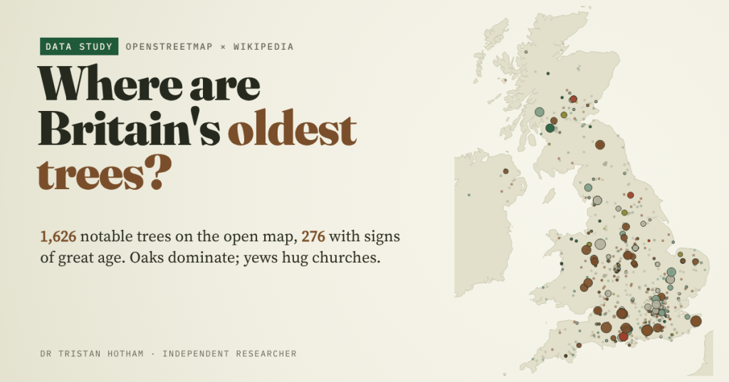
Some of Britain’s trees were already old when the Normans arrived. I went looking for them in the open map of the world, OpenStreetMap, and found 1,626 notable trees: mostly oaks, a cluster of churchyard yews, a few giants in old royal forests, and a great deal of evidence about the people who map trees.
In the churchyard at Fortingall in Perthshire stands a yew that Forestry and Land Scotland reckon is 5,000 years old. Other estimates are a more modest 2,000 to 3,000 years. Nobody can be sure, because the heart of a hollow yew rotted away long ago, and with it the rings you would need to count. In 1771 someone measured its trunk at 56 feet round, about 17.1 metres.
Britain is unusually rich in trees like this. So I wanted to map them: where the big old trees are, which species they are, why so many ancient yews stand by churches, and whether the medieval royal forests left more of them behind. The obvious source, the Woodland Trust’s Ancient Tree Inventory, is not open for reuse, so I did not use it. Instead I used only open data: OpenStreetMap, Wikidata and Wikipedia. That turned out to be a study of two things at once, the trees and the mappers.
A map of enthusiasm
OpenStreetMap holds 70,394 trees in the UK with a name, a girth, an age or a similar tag. Almost all are street and park trees imported from council surveys. Only 1,626 are what I call notable: named, tagged as a landmark, natural monument, ancient or veteran tree, or with a believable girth of 3 metres or more. 276 of them show a sign of great age.
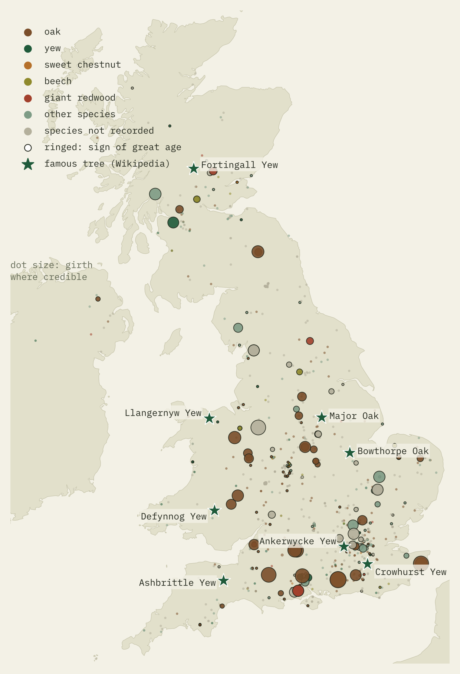
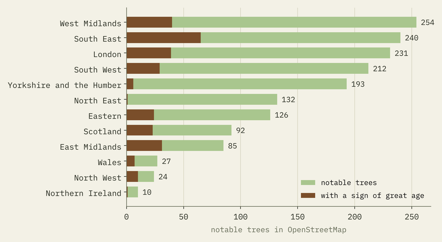
Look closely and the map is lumpy in a way real trees are not. 42% of the notable trees fall in just ten of the 428 ten-kilometre squares that have any. The busiest, around Hood Green near Barnsley, holds 158, nearly all of them unnamed trees of unrecorded species tagged as “landmarks”. Northumberland has 121 more of the same. Across Britain, 40% of the notable trees are like that. Wales, home to some of Britain’s most famous yews, has just 27 notable trees on the open map.
Even the famous trees are patchy. Of the 90 UK trees that Wikidata lists as remarkable or heritage trees, I could find 48 on OpenStreetMap. The Llangernyw Yew in Conwy, which Wikipedia says may be over 4,000 years old, is not in my extract as a named tree at all. So everything below comes with a warning: this is a map of where people have looked.
Mostly oaks
Where the species is recorded, oaks dominate: 273 trees, 47% of the known total and 51% of those with a sign of great age. They also own the biggest girths. The Queen Elizabeth Oak near Lodsworth in West Sussex is tagged at 13.18 metres round; Majesty, the Fredville Oak in Kent, at 12.36. A sweet chestnut nearby at Cowdray, the Cowdray Colossus, comes in at 12.5.
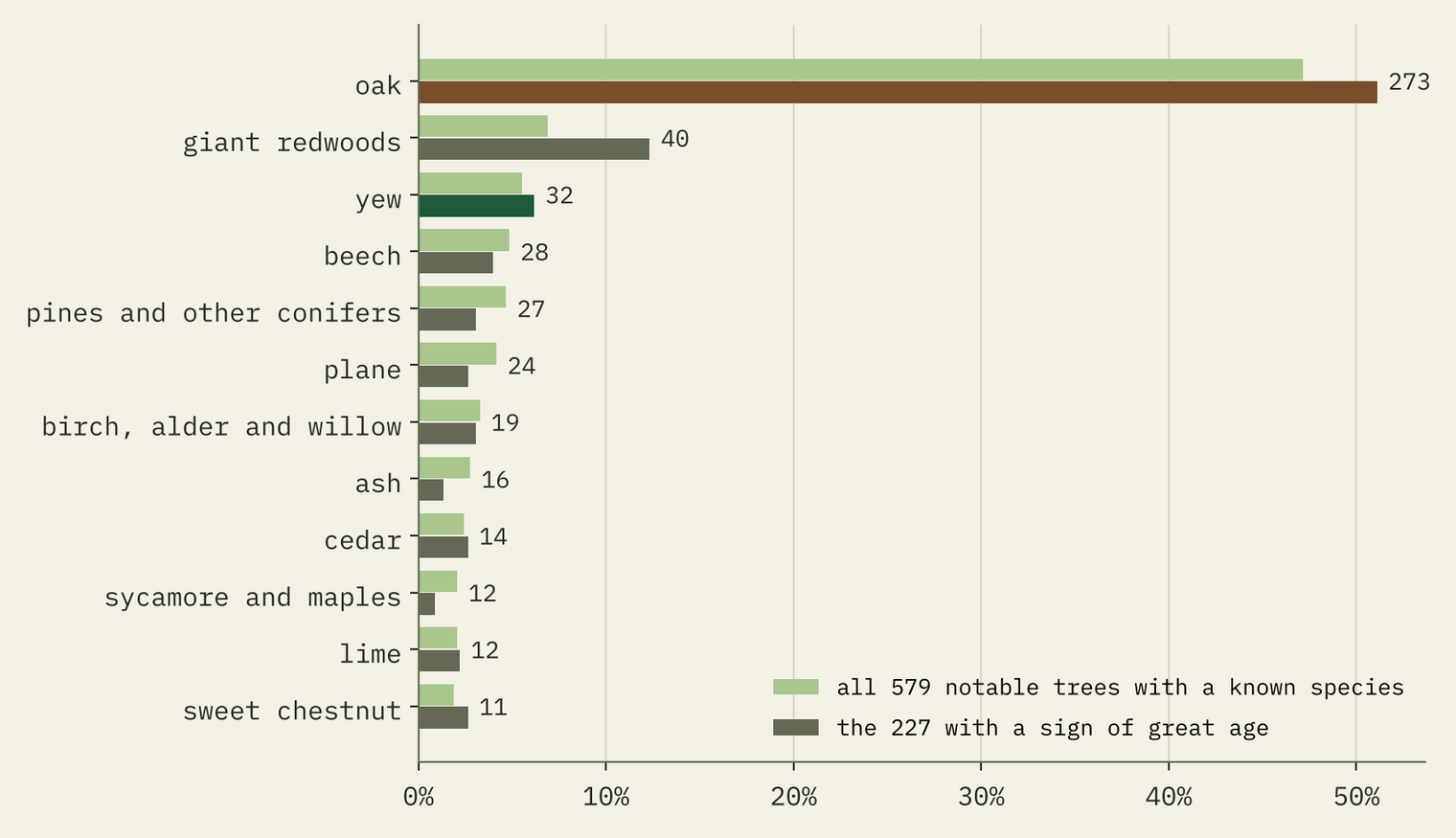
The runner-up among the old-looking trees is a surprise: giant redwoods, 28 of them with a big girth or a monument tag. They are huge, but they are newcomers from California. Size is not age.
The trees by the church door
Yews are different. Of the 176 yews in my extract, 18% stand within 50 metres of a church or chapel. For every other kind of tree the figure is 1.3%. A yew is 13.7 times as likely as other trees to be in or by a churchyard, and among the notable yews the share is 66%.
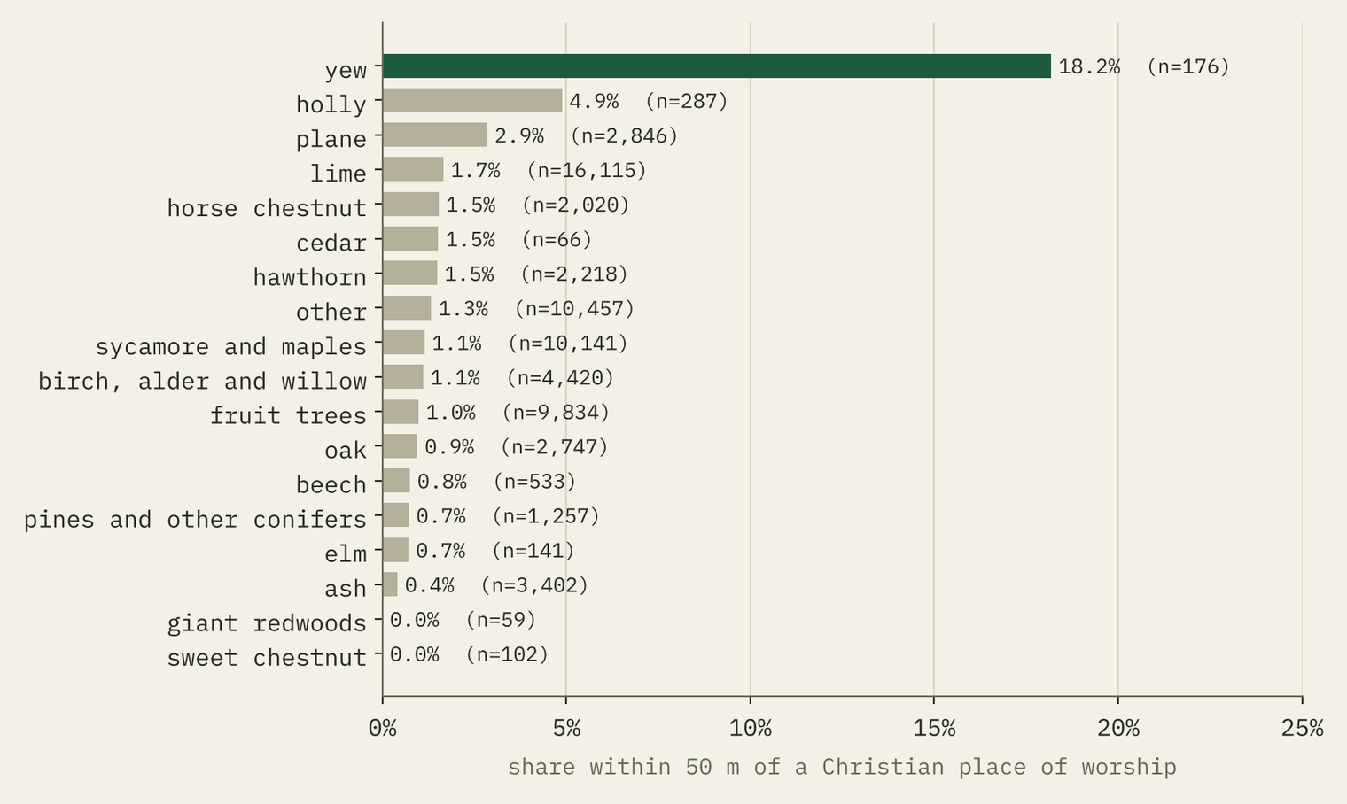
And it is the old churches. 28 of the 32 churchyard yews are nearest an Anglican, Church in Wales or Catholic church; only 2 are nearest a chapel of another denomination, though such chapels are about a third of the places of worship on the map. Five of the six famous ancient yews I took from Wikipedia are in churchyards. Why yews and churches go together is an old argument, and these data cannot settle it. What they do show is that old yews survive where the ground has been a churchyard for a very long time.
A yew is 13.7 times as likely as any other tree to stand by a church.
The king’s forests
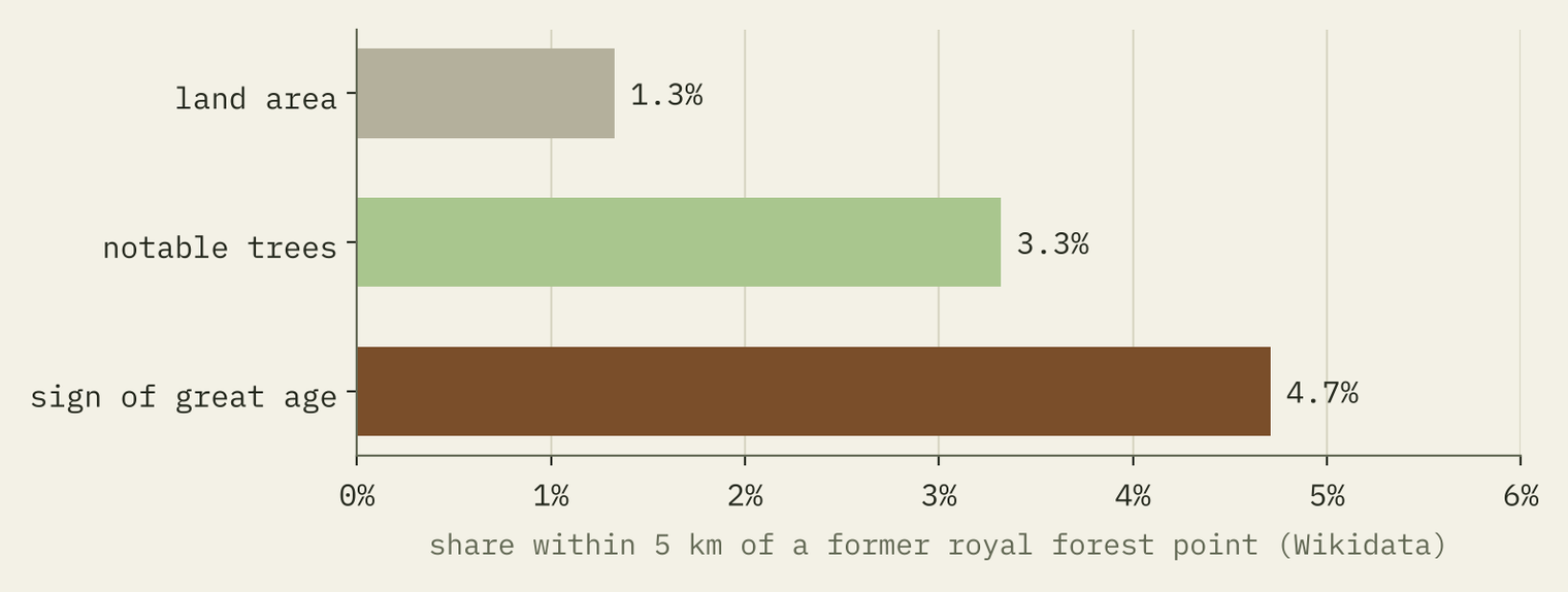
After 1066 the Norman kings put great tracts of land under forest law to protect their deer, and at its height, Wikipedia notes, a third of southern England was royal forest. Within 5 km of the 38 royal forest points in Wikidata, which cover 1.3% of the land, lie 4.7% of the trees with a sign of great age. That is about 3.5 times their share of the land, but only 13 trees, and 9 of them are in the New Forest and Savernake. Savernake, still a forest, has three of the biggest oaks on the map: the Big Belly Oak, the King of Limbs and the Cathedral Oak, all over 10 metres round.
How old is a big tree?
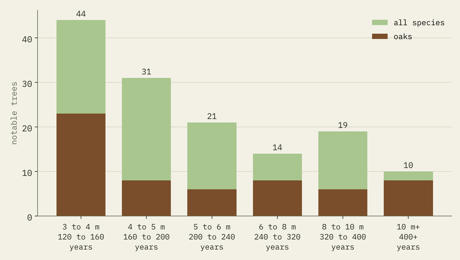
Foresters often use Alan Mitchell’s rule of thumb: an open-grown tree adds about 2.5 cm (an inch) of girth a year. By that rule a girth of 5 metres means about 200 years and 10 metres about 400. 10 notable trees on the open map are 10 metres round or more.
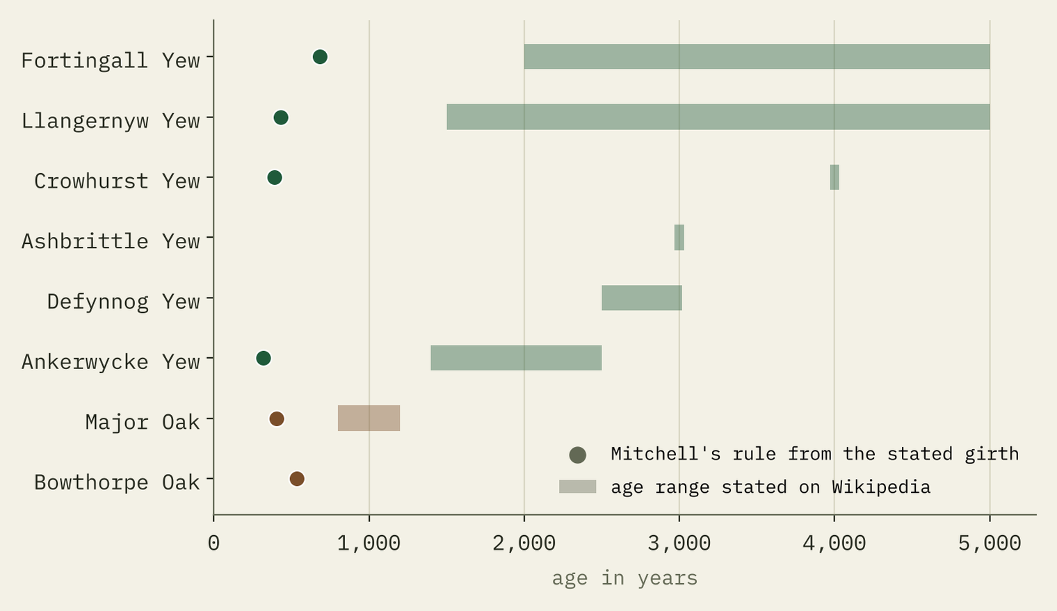
For the truly ancient the rule collapses. The Llangernyw Yew is 10.75 metres round at ground level, which by Mitchell’s rule makes it about 430 years old. Its churchyard certificate says 4,000 to 5,000. The Major Oak in Sherwood, 10.06 metres round in 1999, comes out at about 402 years against the 800 to 1,200 usually quoted. Old trees slow down, shed limbs and hollow out. A big girth tells you a tree is old, not how old.
How I did this
I took every OpenStreetMap tree in the UK with a name, denotation, age, heritage, Wikidata or girth tag, via the QLever query service. I kept trees with a real name (not just “Oak”), a landmark, natural monument, ancient or veteran tag, an age, a Wikidata link or a believable girth of 3 metres or more. Girths were cleaned hard: I dropped survey defaults repeated across whole streets, bare numbers on otherwise empty trees, and anything over 9 metres unless the tree was named or tagged as a monument. A tree is “in a churchyard” if it is within 50 metres of a mapped church; “near a royal forest” if it is within 5 km of the point Wikidata gives for one. The full method and every caveat are in the paper, and the code and data are on GitHub.
If your favourite old tree is missing from the interactive map, that is the point: it has not been mapped yet. You could change that.
Notes and sources
- Trees, places of worship and deer parks: © OpenStreetMap contributors, Open Database Licence, retrieved 28 October 2026 via QLever.
- Royal forests and remarkable trees: Wikidata (CC0).
- Famous trees, forest law and veteran trees: English Wikipedia, Fortingall Yew, Llangernyw Yew, Major Oak, Royal forest, Veteran tree and others (CC BY-SA 4.0).
- Places: OS Open Names, contains OS data © Crown copyright and database right 2026 (Open Government Licence v3.0).
- Mitchell’s rule: Alan Mitchell, A Field Guide to the Trees of Britain and Northern Europe (Collins, 1974).
- Not used: the Woodland Trust Ancient Tree Inventory, which is not open for reuse.
- I wrote the text, with drafting and editing assistance from Claude (Anthropic), which also helped prepare the analysis code. I reviewed and checked all text and results.

