
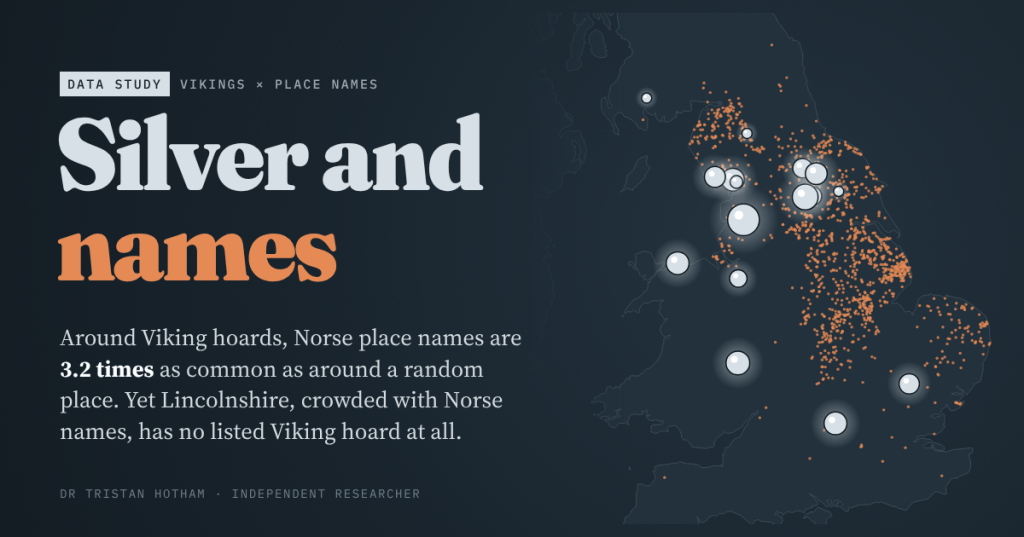
The Vikings left two kinds of trace in Britain: buried silver, and the names of the places they farmed. I put every listed Viking hoard on the map of Norse place names to see whether the two tell the same story. Mostly they do. The exceptions are the best part.
On 15 May 1840, workmen repairing the bank of the River Ribble at Cuerdale, just outside Preston, uncovered a corroded lead box. Inside were more than 8,600 pieces of silver: coins from York, Wessex and across Europe, jewellery, ingots and chopped-up bullion, 32 to 40 kg in all. By the archaeologist Richard Hall’s reckoning it is four times bigger than any other Viking hoard from Britain or Ireland.
Silver like this is one of the two ways we map the Viking Age. The other is names. Grimsby, Scunthorpe, Bassenthwaite, Lowestoft: the endings -by, -thorpe, -thwaite and -toft come from Old Norse words for a village, an outlying farm, a clearing and a homestead. Both are used to draw the map of Viking Britain. I wanted to know if they draw the same map.
So I took the 19 Viking hoards in Wikipedia’s list of hoards in Great Britain and set them against every settlement in the Ordnance Survey’s open gazetteer: 43,274 cities, towns, villages and hamlets, of which 1,360 carry a Norse element by a deliberately strict set of rules.
Silver on the map of names
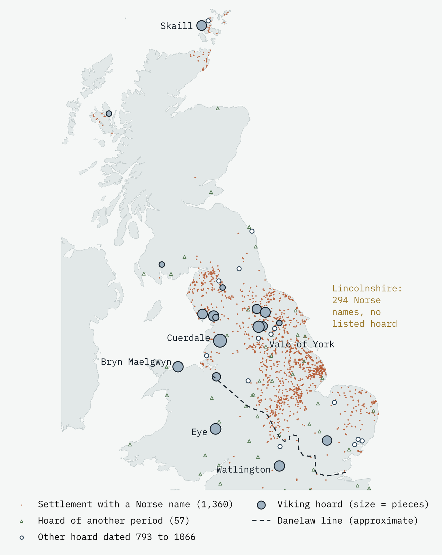
The first thing the map shows is how lopsided the names are. They crowd into Yorkshire, Lincolnshire, the east Midlands, Cumbria and the far north, and are almost absent from the south and west. Wales, by my rules, has none.
The second is that most of the silver sits among them. I drew a 15 km circle round each of the 17 hoards I could place to village level and asked what share of the settlements inside had Norse names. Around a random settlement, the answer is 3.1%. Around the Viking hoards it is 10.0%, 3.2 times as high. In 20,000 random draws of 17 places, a result that high turned up fewer than once in 500 tries.
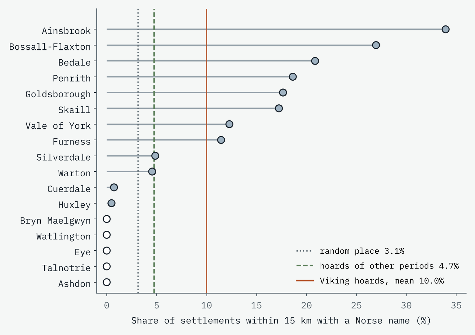
A fair objection is that hoards of any age turn up in the north and east, where ploughs, builders and metal detectors find buried metal. So I ran the same test on the 57 other located hoards in the same Wikipedia list, mostly medieval and later. Their circles average 4.7%, only 1.5 times a random place. The Viking hoards are clearly more Norse than that. The result also holds with 10 km and 25 km circles, for England alone, and with a looser set of names.
North and east of the line
In the late ninth century Alfred of Wessex and the Viking leader Guthrum agreed a frontier: up the Thames, up the Lea, to Bedford, up the Ouse and along Watling Street. North and east of it was the Danelaw. On my approximate tracing of that line, 96.5% of England’s Norse-named settlements fall on the Danelaw side, against 49.0% of all settlements. So do 12 of the 14 English Viking hoards.
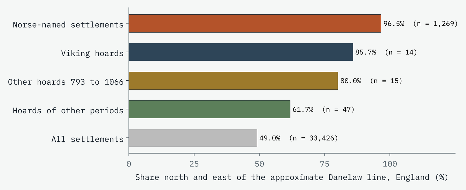
The two that are not are Watlington in Oxfordshire and Eye in Herefordshire. Both are dated to the late ninth century, and both held coins of Alfred and of Ceolwulf II of Mercia. They look less like a settler’s savings than like silver carried through a frontier zone at war.
Silver without names
Five hoards have no Norse-named settlement at all within 15 km: Ashdon in Essex, Talnotrie in Galloway, Eye, Watlington, and Bryn Maelgwyn near Deganwy on the north Welsh coast. Four are late ninth century, the years of the great Viking armies. The fifth, Bryn Maelgwyn, is 204 pennies of Cnut from the early eleventh century. None comes from the tenth century, when most of the northern hoards went into the ground. These look like silver on the move, not silver at home.
The densest Norse-named landscape in Britain is a silver blank.
Names without silver
Turn the question round and the gap is far bigger. 58% of all the Norse-named settlements are more than 50 km from any listed Viking hoard. And one county stands out above all. Lincolnshire has 294 Norse-named settlements, nearly a third of all its settlements and 23% of all of England’s. Places like Spilsby, Skendleby, Revesby and Ingoldsby. It has no Viking hoard in the list, and no hoard of any kind dated between 793 and 1066.
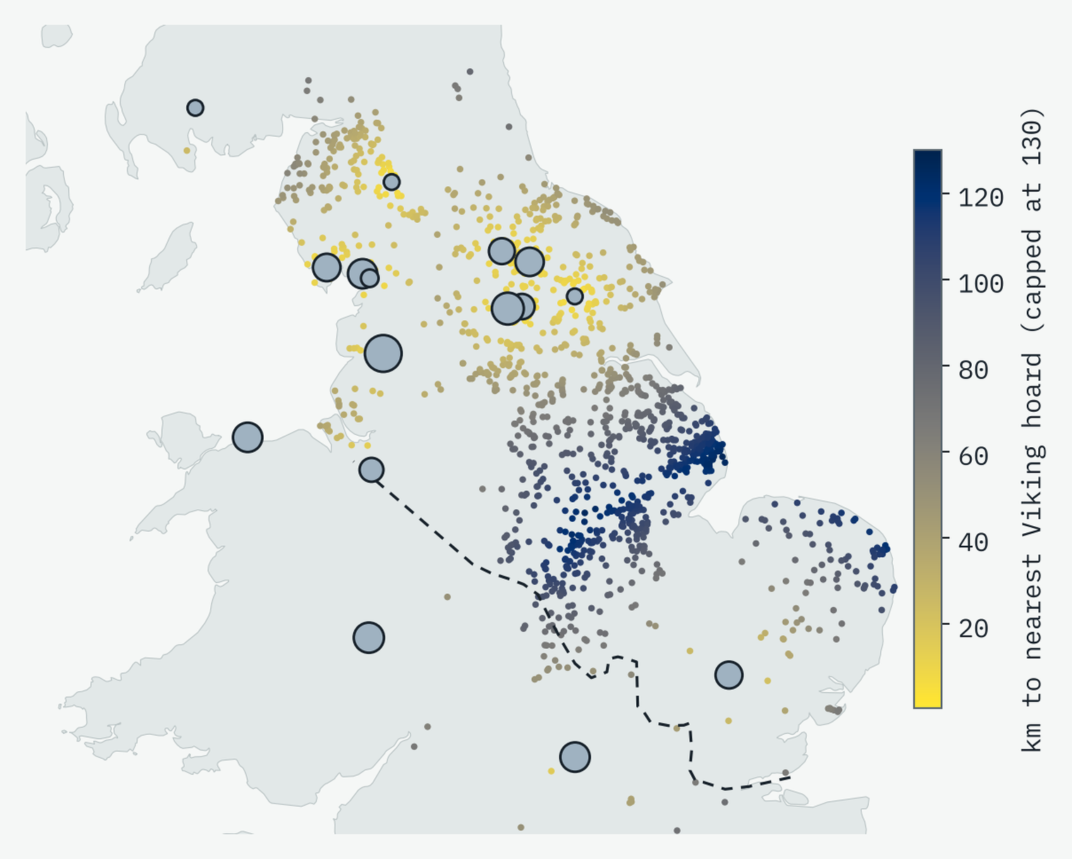
The ten 10 km squares with the most Norse names in Britain are all in Lincolnshire and Leicestershire, and every one is between 85 and 123 km from the nearest listed Viking hoard.
I do not think this means Lincolnshire’s Vikings had no silver. The Wikipedia lists hold notable hoards, the ones famous enough for their own article, not every coin found in a field. A full count from the Portable Antiquities Scheme could look different, and that is the next test. But the famous hoards that shape the public picture of Viking silver do not come from the most Norse-named corner of England.
The giant on the Ribble
Cuerdale shows the same split at a single spot. On its own it is 80% of all the pieces counted across the 16 Viking hoards for which the lists give a number, and about 12.6 times the Vale of York Hoard, the next biggest.
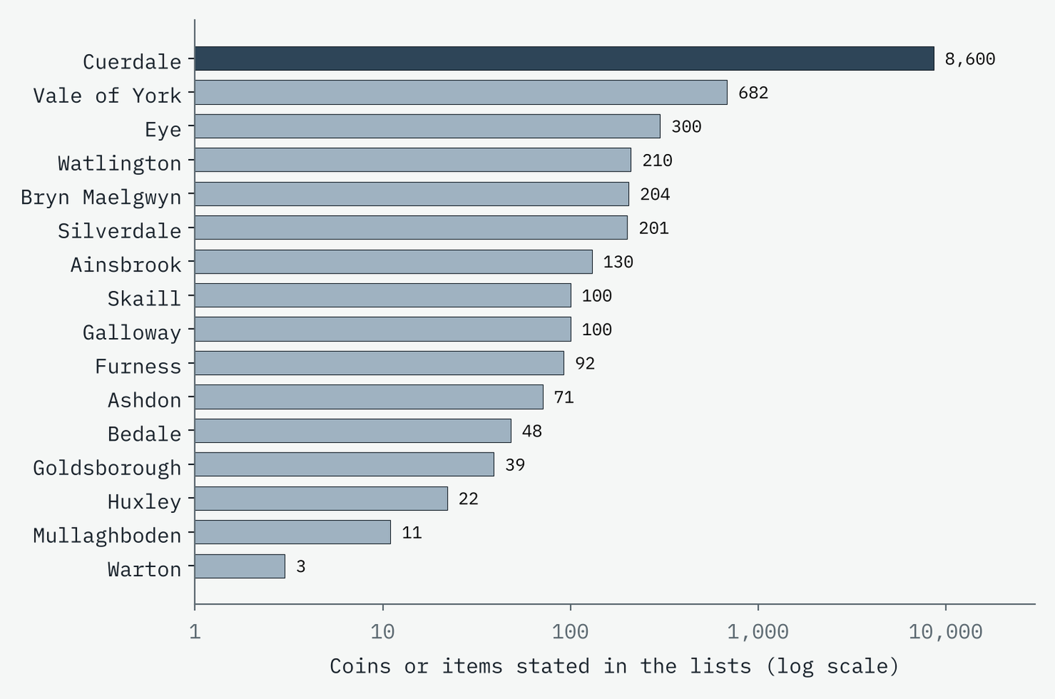
It was buried, probably between about 903 and 910, beside the Ribble, which in the Viking Age was a route between the Irish Sea and York. One theory is that it was a war chest for Norse exiles hoping to retake Dublin. Yet only 2 of the 275 settlements within 15 km of it have Norse names, and 8 within 25 km: Thorpe Green, Kirkham, Ribby, Westby and a handful more. Lancashire as a whole has just 13 Norse-named settlements by my count. The richest hoard sits among few names, and the richest names sit with no hoards. That is just what you would expect if Cuerdale was silver passing through on a river road, not the wealth of the farms around it.
One more surprise: Viking hoards are not especially close to the sea. Their median distance to tidal water is 20.1 km, further than a typical settlement (14.9 km). A few sit right at the water’s edge, Cuerdale, Silverdale and Warton among them, but most lie well inland.
How I did this
The hoards are every row of the “Viking hoards” tables in Wikipedia’s lists of hoards in Great Britain and Ireland, placed at the village-level coordinates the lists give, with a few placed from their stated find place. The Galloway Hoard’s find spot is withheld, so it is not mapped, and the Irish hoards are mapped but not tested, because the place-name data cover Britain only. The names are OS Open Names settlements, matched as whole words to -by, -thorpe, -thwaite, -toft, kirk-, -scale and, in the far north, -ster, -bister and -bost, with meanings only from cited sources. To avoid false friends, kirk counts only in England (Falkirk is Scots), and Welsh and Gaelic look-alikes such as Llangibby and Abercrombie are excluded. Even so, a name on today’s map is not proof of a Viking founder.
The baseline is 20,000 random draws of settlements, and the 57 hoards of other periods from the same list. The Danelaw line is my hand-placed tracing of the treaty, as in my earlier study of Britain’s landscape words.
Notes and sources
- Hoards: Wikipedia, List of hoards in Great Britain, List of hoards in Ireland and Cuerdale Hoard (CC BY-SA 4.0), cross-checked against Wikidata (CC0).
- Place names and rivers: OS Open Names and OS Open Rivers. Contains OS data © Crown copyright and database right 2026 (Open Government Licence v3.0). Coastline: Natural Earth.
- Element meanings: Wikipedia, List of generic forms in place names in the British Isles and Toponymy of England; Survey of English Place-Names, Scaleby; Shetland Amenity Trust, Bisters.
- Paper, data and code: Zenodo and GitHub.
- I wrote the text, with drafting and editing assistance from Claude (Anthropic), which also helped prepare the analysis code. I reviewed and checked all text and results.

