
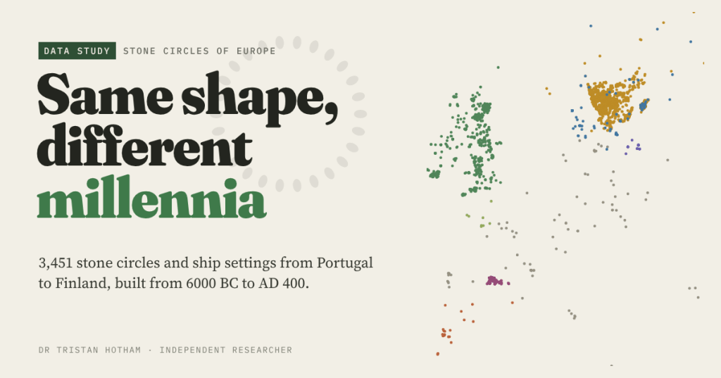
Stonehenge, Castlerigg, the Ring of Brodgar: stone circles feel British. So I put every stone circle in Europe’s open map data on one map, 3,451 of them, and asked when each group was built. The same simple ring turns up from 6000 BC to AD 400.
Stone circles have a strong home address. Archaeologists list about 1,300 of them in Britain, Ireland and Brittany, raised between roughly 3300 BC and 900 BC. When most of us picture one, we picture a wet hillside in Cumbria or a low sun on Orkney.
But a ring of upright stones is about the simplest monument anyone can build. You need a field, some boulders and a sense of the middle. So I wanted to know where else it turns up, and when. I gathered every stone circle I could find in OpenStreetMap and Wikidata, Europe’s two big open datasets, cleaned out the street names and car parks, merged the duplicates, and sorted what was left into the traditions archaeologists recognise. Then I dated each tradition from published sources and from radiocarbon dates linked to named circles.
Every ring on one map
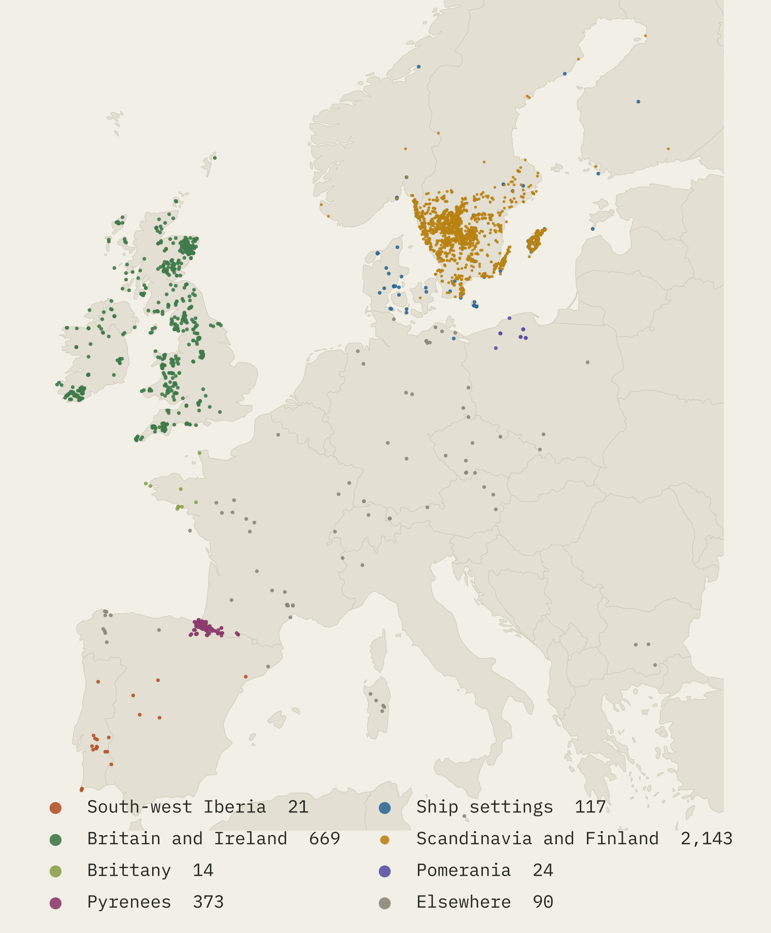
The first surprise is where most of the dots are. Not in Britain, but in Sweden. 62% of the records, 2,143 of them, are Iron Age domarringar, or judge’s rings, in Scandinavia and Finland. Only 20% are the Neolithic and Bronze Age circles of Britain, Ireland, Brittany and Iberia.
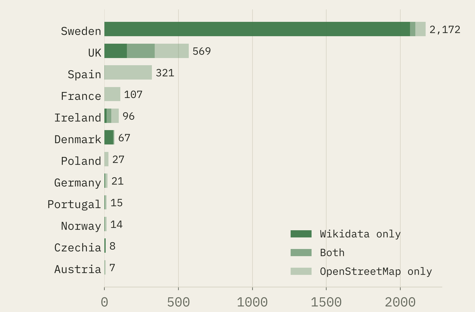
Some of that is real and some is the data. 95% of Sweden’s 2,172 records are in Wikidata only, almost all as unlabelled items that look like a bulk import from the national heritage register. Britain and Ireland have no such import, and my map holds only about 53% of the circles archaeologists list there. Counted per area, Sweden still comes out on top, but the size of its lead says as much about who digitised what as about the Iron Age.
A ribbon of dates
Almost no record carries its own date, so I dated the traditions instead, from their published ranges. Laid side by side, they split into two blocks.
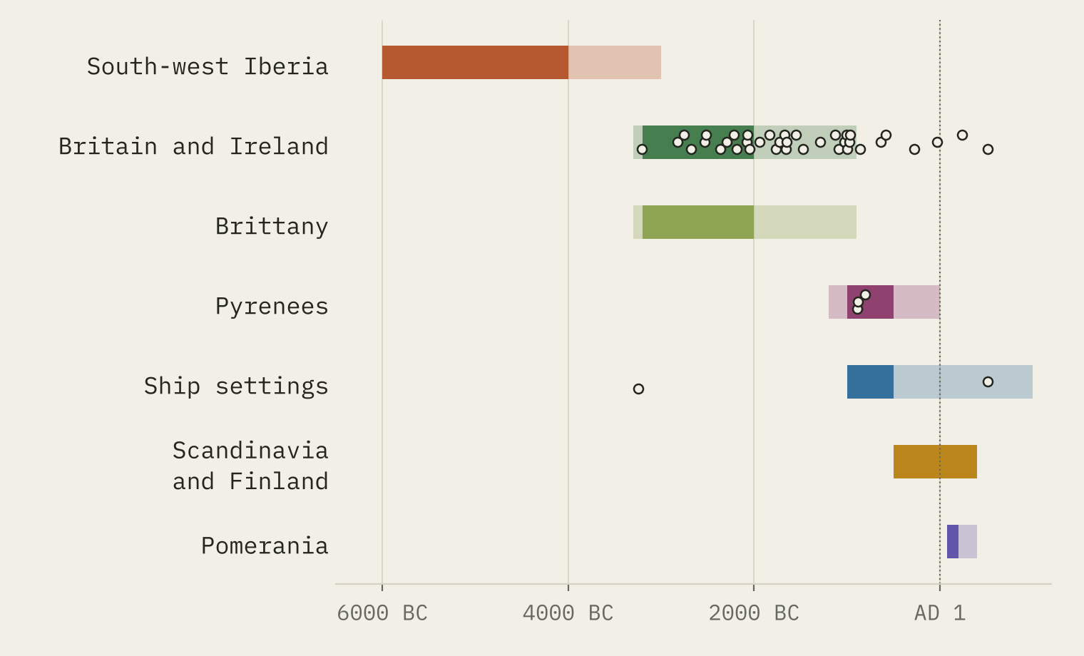
The first block is Atlantic and early. The cromlech of Almendres in Portugal is dated to the sixth millennium BC. Britain, Ireland and Brittany follow from about 3300 BC, with most circles raised between 3200 BC and 2000 BC.
The second block is late and mostly northern. Small rings around cremation burials appear on the high pastures of the western Pyrenees from about 1200 BC. Ship settings, ovals of stones in the outline of a boat, appear around the Baltic from about 1000 BC. The Swedish and Finnish judge’s rings run from about 500 BC to AD 400. And the Goths of the Wielbark culture laid out stone circles in their cemeteries at Odry, Węsiory and Grzybnica in Pomerania from the later first century AD.
The radiocarbon dates back this up where they exist. I linked 356 dates from the p3k14c database to 43 named circles. In Britain and Ireland, 30 of 37 dated circles have a middle date inside the published range; most of the rest are later burials and fires at old monuments. Three dated Pyrenean rings fall between 890 BC and 804 BC. Sweden’s thousands of judge’s rings have almost no dates in the database at all.
The same simple shape was built over 6,400 years, from Portugal to Finland.
Same ring, different habits
The traditions do not just differ in date. Pyrenean rings come in crowds: 84% have another ring within a kilometre, and almost none is near the sea. Ship settings hug the coast: 63% are within 5 km of it. Pomeranian circles sit inside cemeteries, and 75% have a neighbour within 100 m. British and Irish circles are more often loners: only 13% do.
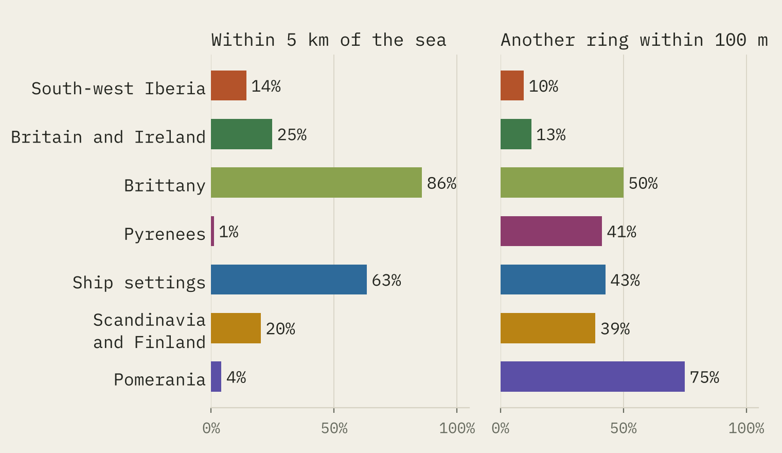
An island invention, or a shape people keep finding?
If the circle spread from one source, neighbouring traditions should touch in both space and time. So for each pair I measured the closest distance between their records and the gap between their dates.
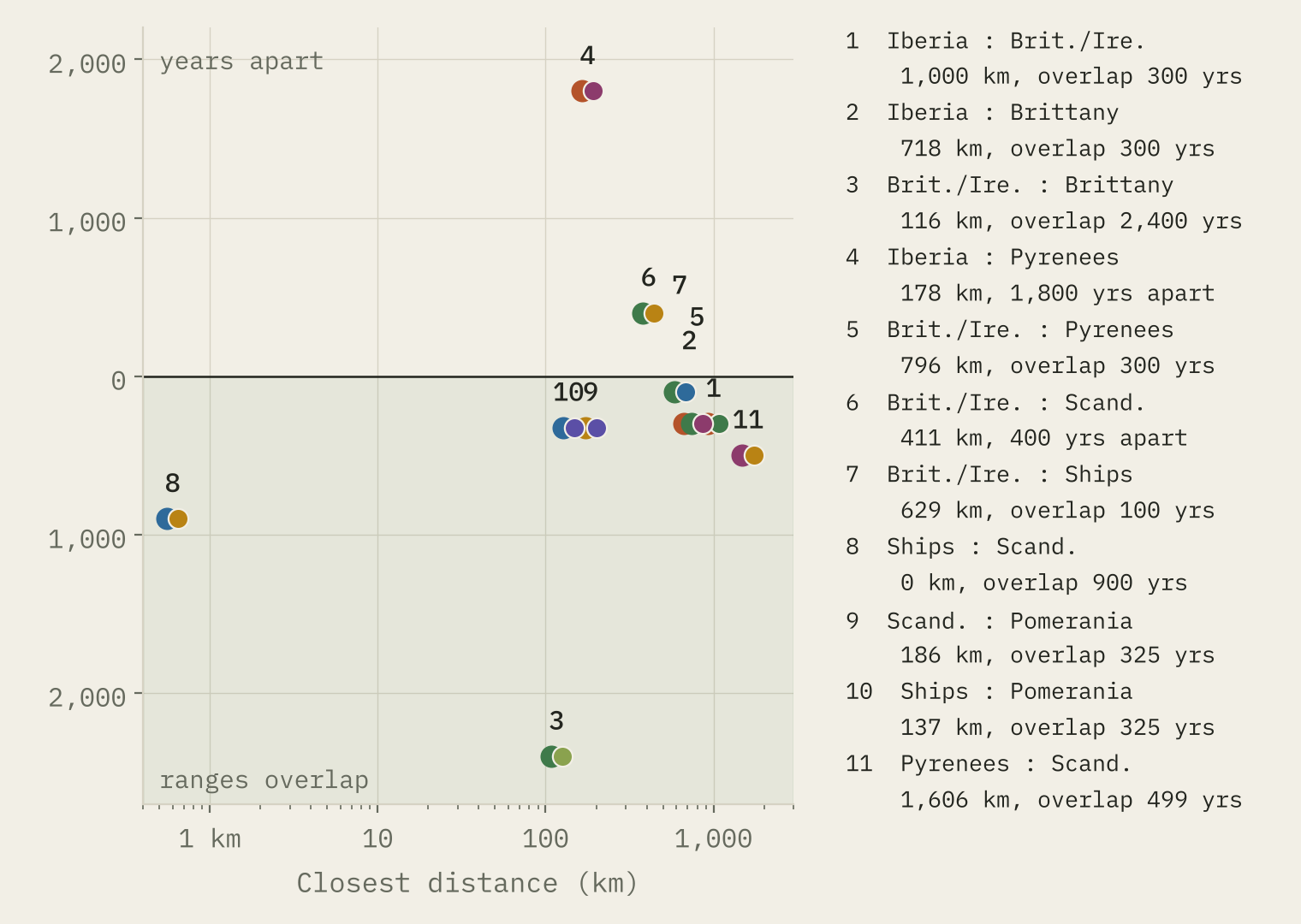
Some pairs touch. Britain and Brittany are 116 km apart and share their dates. The Swedish judge’s rings and the Pomeranian circles face each other 186 km across the Baltic and overlap by 325 years.
Others do not. The closest British circle to any Scandinavian one is Hjaltadans in Shetland, 411 km of sea from Norway, and about 400 years separate the end of one tradition from the start of the other. The Alentejo cromlechs and the Pyrenean rings are only 178 km apart at their closest, but some 1,800 years apart in date.
My careful answer: probably not one invention. The map fits at least two separate beginnings, an Atlantic one in the Neolithic and a northern one in the Iron Age, with the Pyrenees as a possible third. I cannot prove that people reinvented the ring. Ideas can travel without leaving stones behind, and plenty of circles are missing from the data. But it looks like a shape that people kept finding.
A rise, not a summit
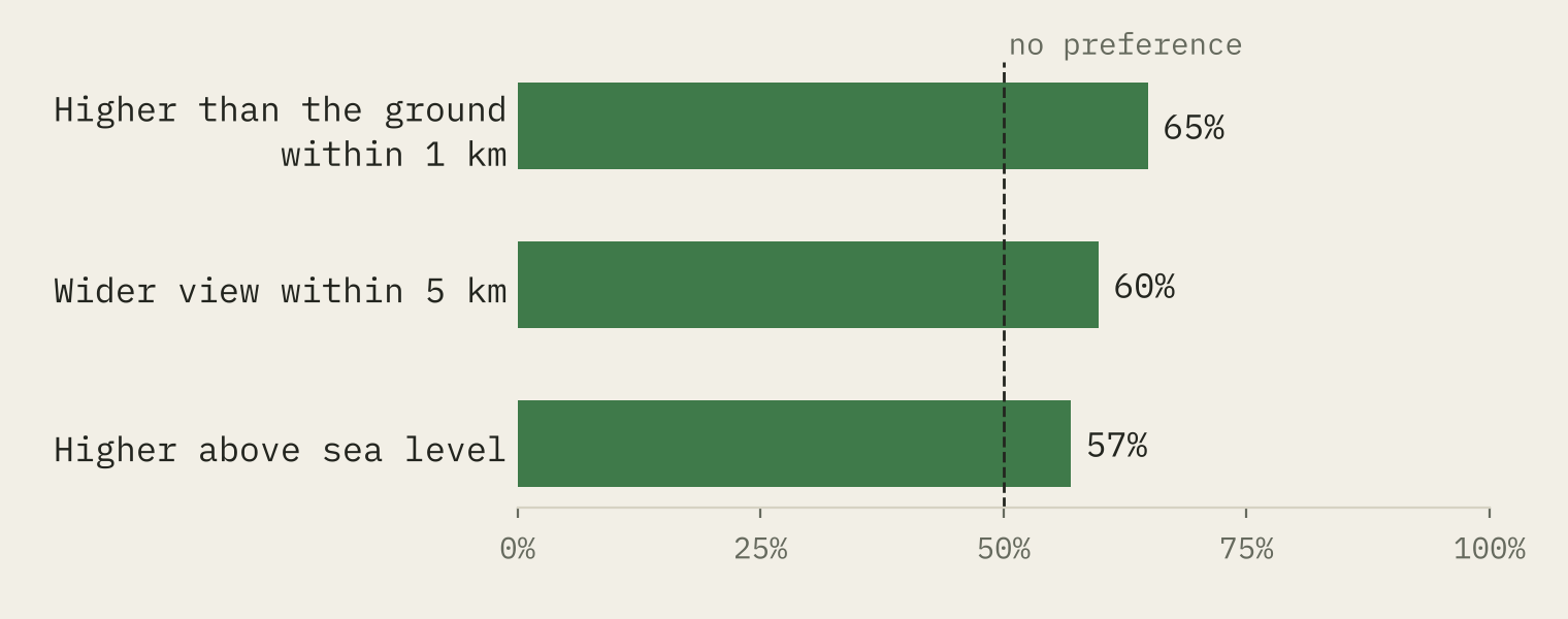
For Britain and Ireland I also have a terrain model, so I compared each circle with ten random points 1 to 5 km away. 65% of circles stand higher, relative to the ground around them, than the typical comparison point, and 60% have a wider view. A real preference, but a gentle one: circle builders liked a shoulder or a low rise, not the top of the hill.
How I did this
From OpenStreetMap I took objects tagged as stone circles, cromlechs or stone ships, plus objects whose names contain a stone circle word in several languages, keeping only those with a historic tag and without street, shop, trail or modern words in the name (117 of 2,415 name matches survived). From Wikidata I took stone circles and stone ships in Europe. I merged 278 OSM objects with their Wikidata twins, by shared identifier or within 100 m, and removed 22 modern circles. Traditions are assigned by place. Radiocarbon dates come from p3k14c, linked by name within 1 km and calibrated with IntCal20. Every number, rule and link is in the data files.
This is one of three studies built from the same pull of open data. The companions are Megalith Highway and Barrows of Europe.
Notes and sources
- Circle records: © OpenStreetMap contributors (ODbL 1.0), pulled on 27 October 2026, and Wikidata (CC0).
- Radiocarbon dates: Bird and others 2022, p3k14c (CC BY 4.0), calibrated with IntCal20 (Reimer and others 2020).
- Published date ranges: Wikipedia on stone circles in the British Isles and Brittany, Almendres Cromlech, stone ships, Iron Age stone circles and the Wielbark culture; Mujika-Alustiza and others 2018 on Pyrenean circles; Medieval Heritage on Odry and Grzybnica.
- Elevation: AWS Terrain Tiles (Mapzen and Tilezen). Coastline and countries: Natural Earth (public domain).
- Paper, data and code: Zenodo and GitHub. Derived data under ODbL 1.0; text and figures CC BY 4.0; code MIT.
- I wrote the text, with drafting and editing assistance from Claude (Anthropic), which also helped prepare the analysis code. I reviewed and checked all text and results.

