
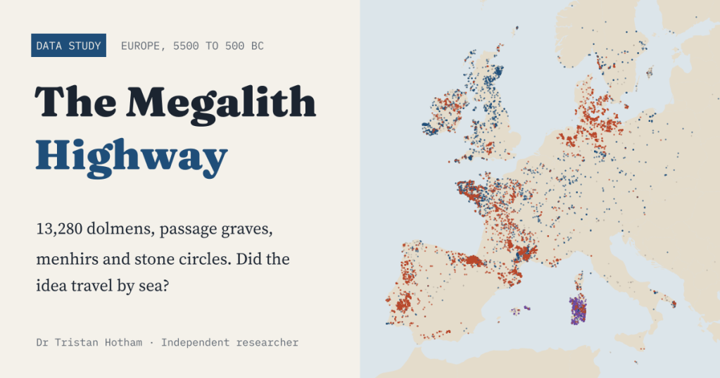
From Portugal to Orkney, Neolithic farmers built the same great stone tombs. Did the idea sail up the Atlantic coast? I put 13,280 megalithic monuments on one map and gave the sea-route story three honest tests.
Crawl into a passage grave in Brittany and you are in a long, low corridor of upright slabs, roofed with stones that took dozens of people to move, leading to a chamber for the dead. Do the same in the Boyne valley, on Orkney, in northern Portugal or on a Danish island and you will find the same idea, built by people who never wrote anything down and lived hundreds of miles apart.
An old and attractive explanation is that the idea went by boat. In 2019 Bettina Schulz Paulsson modelled more than 2,400 radiocarbon dates and argued in PNAS that megalithic graves appeared first in north-west France and spread from there, in a few phases, by sea. I wanted to know what open data could add. So I gathered every megalithic monument that volunteers have mapped in OpenStreetMap and set them three tests.
Everything megalithic on one map
After cleaning, the map holds 13,280 monuments in 34 countries: 4,352 dolmens, 3,064 menhirs and standing stones, 1,345 stone circles, 557 passage graves, 188 long barrows and many more, plus 1,142 nuraghi and talaiots, the Bronze Age stone towers of Sardinia and the Balearics, which I kept as their own class.
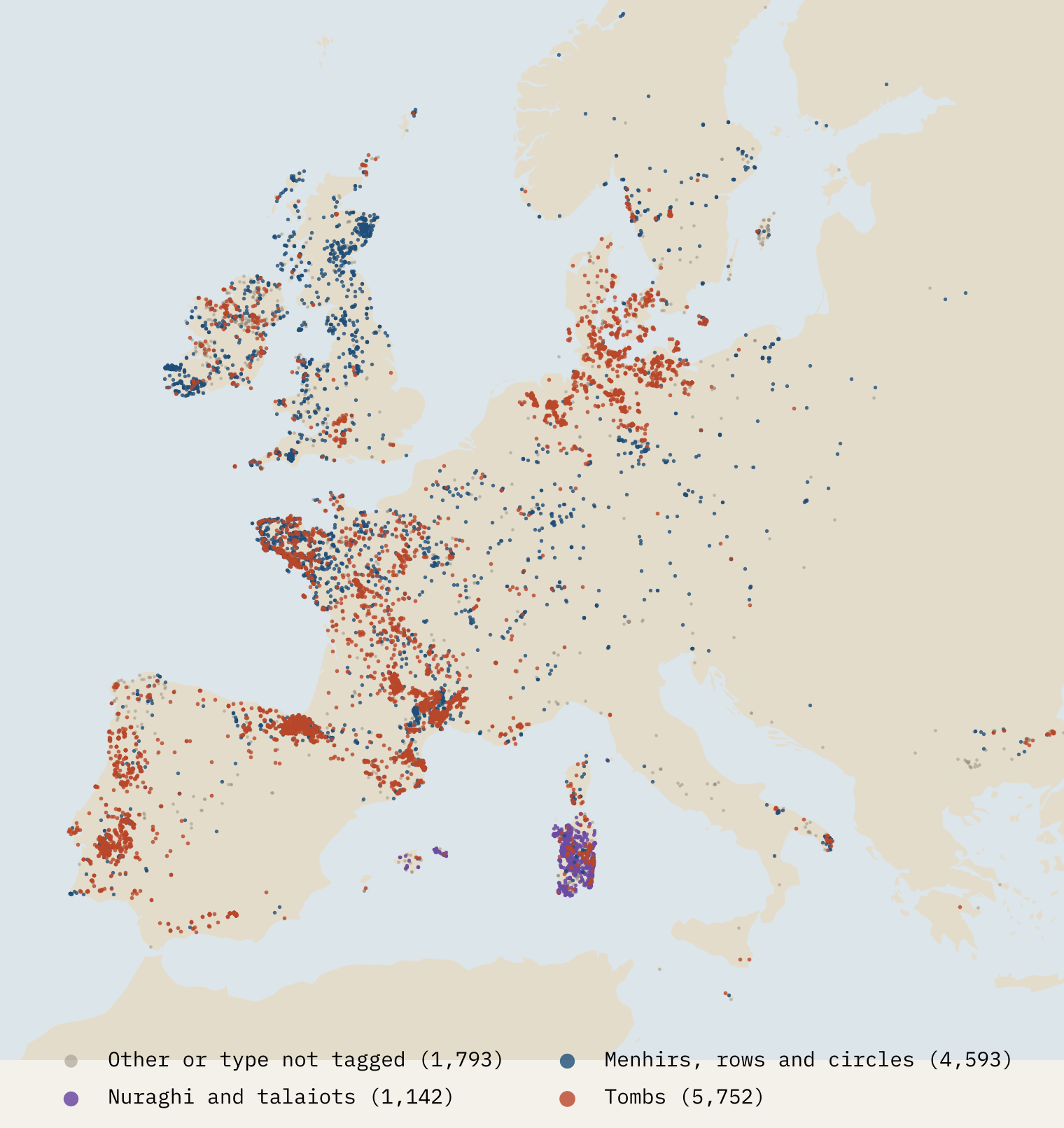
It is a beautiful map, but read it with care. It shows where volunteers have mapped and how they tagged. France has 4,063 megaliths in it, Denmark, famous for its dolmens, only 306, because Danish mappers have mostly tagged their tombs as plain mounds. So every test below compares like with like, within the same countries.
Test one: do they hug the sea?
At first sight, yes. 29% of the monuments stand within 10 km of the sea. Ten random points on land for every monument, in the same countries, put only 13% that close. Megaliths are 2.3 times as likely to be near the sea as the land they stand in.
But random land is a soft target. Prehistoric people did not live at random, and coasts are good places to farm and fish whatever you build for your dead. So I also compared the megaliths with the 46,596 ordinary barrows and burial mounds in OpenStreetMap, weighted to the same mix of countries. Against them, the edge shrinks to 29% against 23%. Because monuments come in clusters, I resampled 50 km squares of the map to get an honest range for the megalith figure: 22% to 37%. That range includes the barrows.
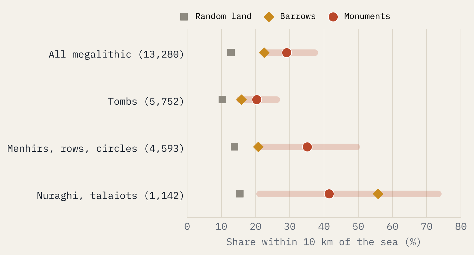
The tombs are the least coastal group, 20% within 10 km against 16% of barrows. The standing stones are the most striking: 35% of menhirs, stone rows and circles are within 10 km of the sea, 1.7 times the barrow figure. Portugal goes the other way altogether: its great dolmen fields lie inland, and only 8% of its mapped megaliths are near the coast.
Test two: where are the oldest dates?
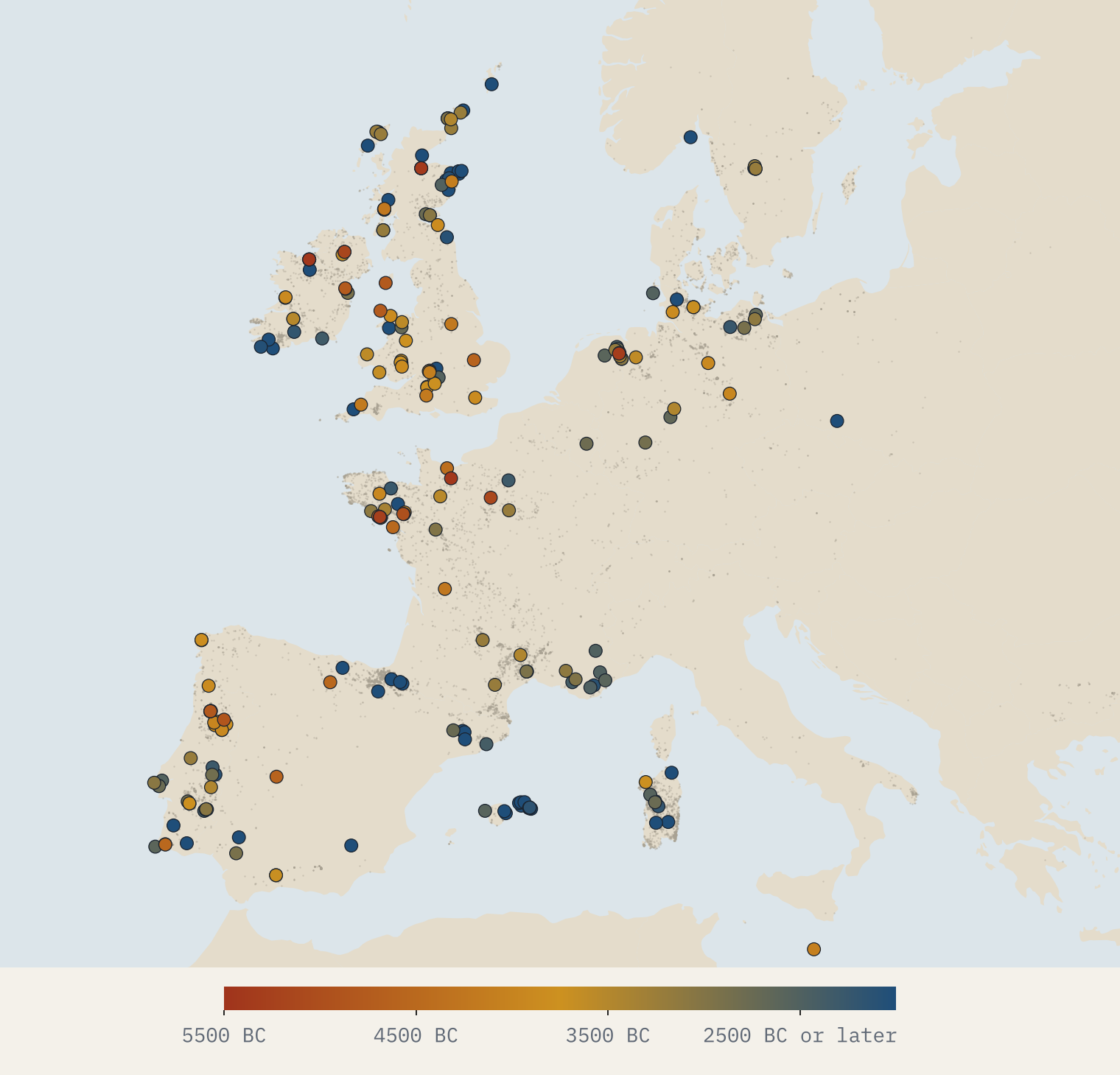
Distance cannot tell you which way an idea moved. Dates can. I took the p3k14c database of radiocarbon dates and linked sites to megaliths by two rules: the site name contains a megalithic word (dolmen, anta, mamoa, hunebed, long barrow and so on), or it shares a distinctive name with a mapped megalith within 1 km. That linked 254 monuments. I checked 50 links at random: 42 were right, seven unclear and one wrong.
One early date proves little, because charcoal can be old when it burns and people used these places before the stones went up. So for each region I asked when the earliest tenth of its dated tombs had begun, and how sure we can be.
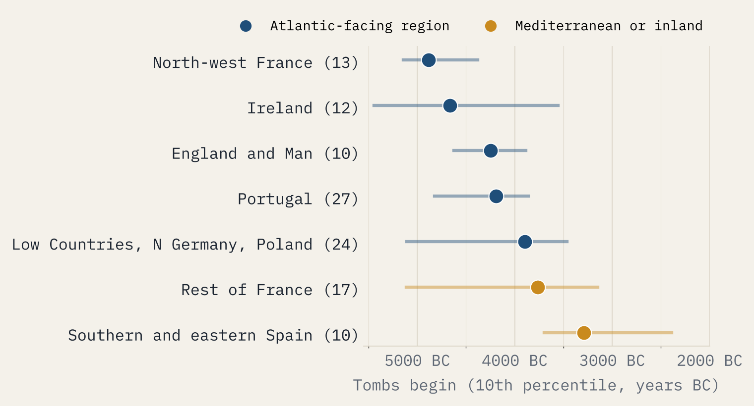
North-west France comes first, at about 4885 BC, just as Schulz Paulsson found. Ireland follows at about 4667 BC, then England, Portugal (4190 BC) and the Low Countries. The rest of France and southern and eastern Spain come last. Taken together, tombs in Atlantic-facing regions start earlier than the rest: median 3465 BC against 2590 BC.
The data fit the highway. They do not prove anyone sailed it.
Now the small print. North-west France rests on just 13 dated tombs, and its range runs from about 5145 to 4382 BC, overlapping its rivals. And inside regions, tombs on the coast are not earlier than tombs inland: the correlation is 0.00. If boats carried the idea, they carried it between regions, not visibly from the beach inland.
Test three: the Atlantic facade, type by type
Finally I split Europe into three zones: within 50 km of the Atlantic and northern seas, within 50 km of the Mediterranean and Black Sea, and inland. 47% of megaliths are in the Atlantic zone, against 27% of random land. Some types are almost entirely Atlantic: 90% of long barrows, 85% of Irish court, portal and wedge tombs, 79% of stone rows and 73% of stone circles.
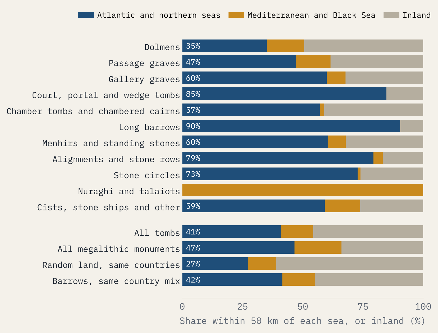
The twist is the tombs. Taken together they sit in the Atlantic zone no more often than ordinary barrows in the same countries: 41% against 42%. Their Atlantic flavour is largely the Atlantic flavour of where prehistoric people buried their dead at all.
So, was there a highway?
All three tests lean the same way. Megaliths are more coastal than the land around them, the earliest dated tombs are in north-west France with the Atlantic regions next, and the most distinctive types belong to the Atlantic fringe. That is what an idea carried by sea would leave behind.
It is also what you would see if Atlantic Europe simply had more good stone near the coast, more people living there and more archaeologists with radiocarbon budgets. The tombs are only modestly more coastal than other burial mounds, and the regional dates rest on a few dozen tombs at best. I came away thinking the sea-route story is very much alive, and that open data alone cannot settle it.
How I did this
Monuments are OpenStreetMap objects tagged as megaliths, sorted into twelve classes and placed in countries with Natural Earth borders; points of the same type within 15 m were merged. Distances are to the present-day coastline, which has moved since the Neolithic, especially around the North Sea and the Baltic. Radiocarbon dates come from p3k14c, without shell dates, calibrated one by one with the IntCal20 curve. Regions with fewer than eight dated tombs are left out of the ranking, which is why Sardinia, Scandinavia and Orkney do not appear. The interactive version lets you filter the map by type, country and period, and play the dated tombs appearing over time. Companion studies from the same data: Stone Circles and Barrows of Europe.
Notes and sources
- Monuments and barrows: © OpenStreetMap contributors, Open Database Licence (ODbL 1.0), extract of 27 October 2026.
- Radiocarbon dates: Bird, D. et al. 2022, p3k14c, a synthetic global database of archaeological radiocarbon dates, Scientific Data 9, 27.
- Calibration: Reimer, P. et al. 2020, The IntCal20 Northern Hemisphere radiocarbon age calibration curve, Radiocarbon 62, using the curve file from the rcarbon package.
- Schulz Paulsson, B. 2019, Radiocarbon dates and Bayesian modeling support maritime diffusion model for megaliths in Europe, PNAS 116 (9), 3460 to 3465.
- Period labels in part from Wikidata (CC0); coastlines and borders from Natural Earth (public domain).
- Paper, data and code: Zenodo and GitHub.
- I wrote the text, with drafting and editing assistance from Claude (Anthropic), which also helped prepare the analysis code. I reviewed and checked all text and results.

