
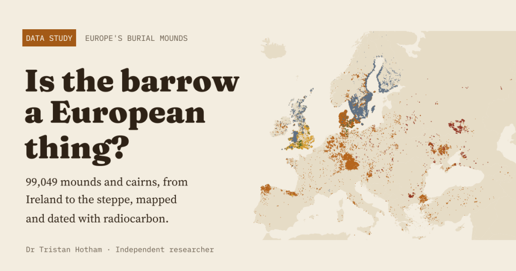
Long barrows in Wessex, cairns in Sweden, kurgans on the steppe. I mapped 99,049 burial mounds across Europe and dated them with radiocarbon to ask a simple question: is the barrow a European thing, or a north-west European one? The answer turned out to be as much about record-keeping as about the Bronze Age.
Walk the chalk downs of southern England and they are everywhere: grassy humps on the skyline, some long, most round, raised over the dead by people who farmed there four or five thousand years ago. Barrows feel very British. The word is Old English, for a hill or a grave mound, and “low” and “howe” still mark mounds on the map.
But the Danes have their høje, the Swedes their rösen, the Germans their Hügelgräber and the Dutch their grafheuvels, and across the plains of Ukraine and southern Russia stand the kurgans. So I wanted to know: is the barrow a European thing? Is there a “barrow belt” across northern Europe? And is the steppe the other heartland?
A hundred thousand mounds
I pulled every burial mound and burial cairn I could find in two open sources, OpenStreetMap and Wikidata, from Ireland to the Urals, removed the ones that appear in both, and sorted them by type: long barrows, round barrows, burial cairns, kurgans, and the great majority that are simply recorded as a tumulus. That gives 99,049 barrows in Europe, in 40 of 51 countries.
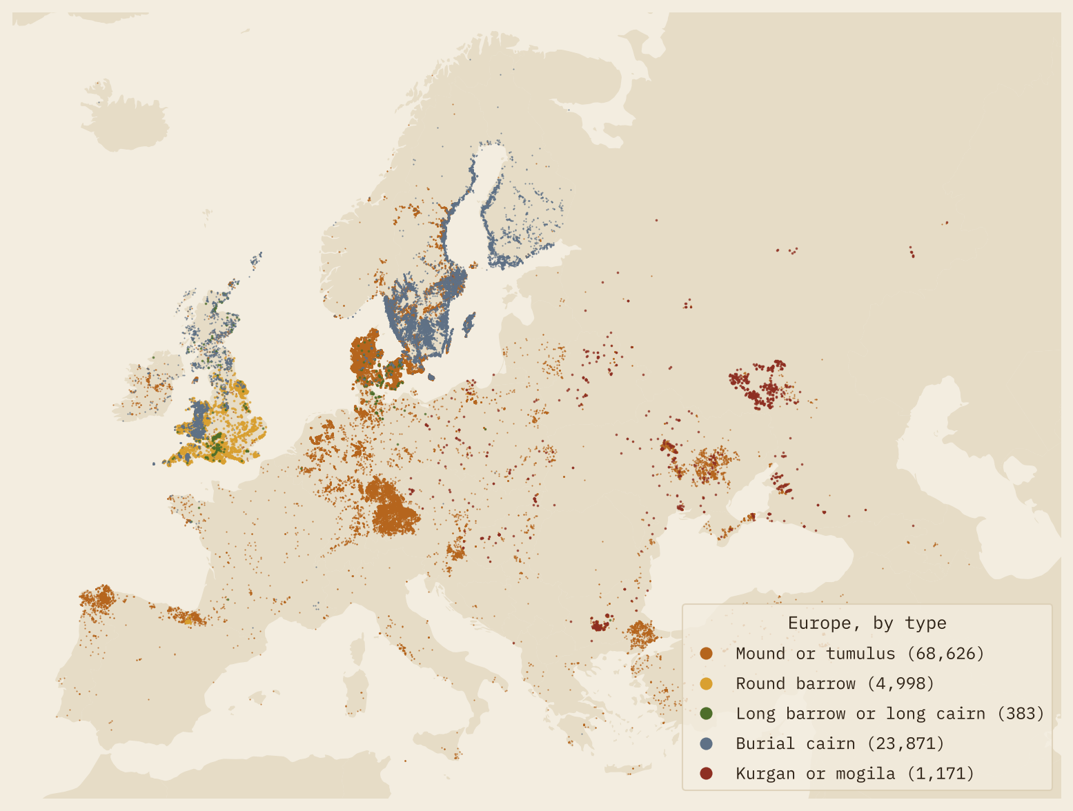
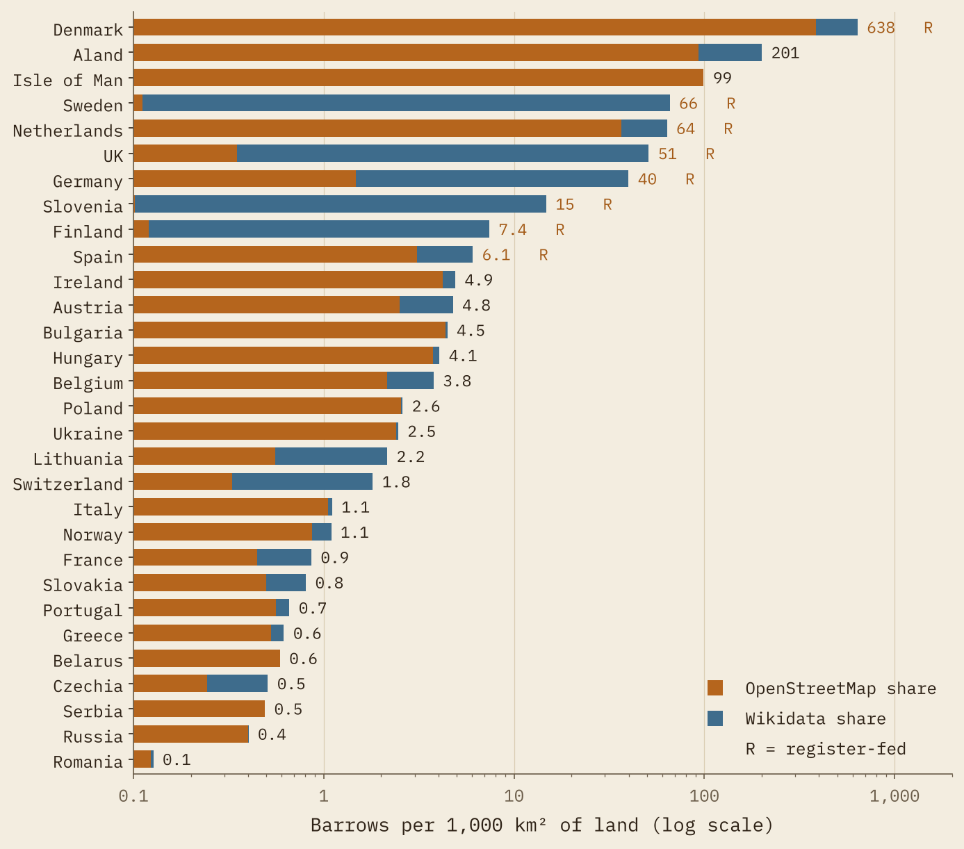
At first sight the answer is obvious. The barrows crowd the north: 83% of them lie north of 50° N, which holds 62% of Europe’s land, and 75% sit in the band between 50° and 60° N, which has just 38% of the land. Denmark alone has 27,236, an astonishing 638 for every 1,000 km². All ten of the densest 50 km squares in Europe are in Denmark and Sweden. A barrow belt, surely.
Who did the counting?
Then I looked at where the records came from, and the belt started to look different. In Sweden, 28,844 of the 29,324 barrows are Wikidata items, 99% of them without even a name: they were created in bulk from the national register of ancient monuments. In Denmark the Wikidata barrows sit a median of 3.6 m from an OpenStreetMap barrow, a sign that both were drawn from the same national list. Germany’s come almost entirely from Bavaria’s monument list, and Britain’s carry the long descriptive names of the scheduled monument lists (“Bowl barrow on Huggate Wold, 500m NNW of Horsedale Plantation”).
I called a country “register-fed” when Wikidata holds a large block of barrows for it. Eight pass: Sweden, Denmark, Germany, United Kingdom, Spain, Finland, Netherlands and Slovenia. Between them they have 20% of Europe’s land and 92% of its mapped barrows. Everywhere else, the density is 1.0 barrow per 1,000 km²: what volunteers have mapped by hand.
Take those eight countries out and the northern tilt disappears. In the other 43 countries, 41% of the barrows lie north of 50° N, on 61% of their land. The densest band outside the registers is not the North Sea coast at all, but central Europe: Austria, Hungary, Czechia, southern Poland.
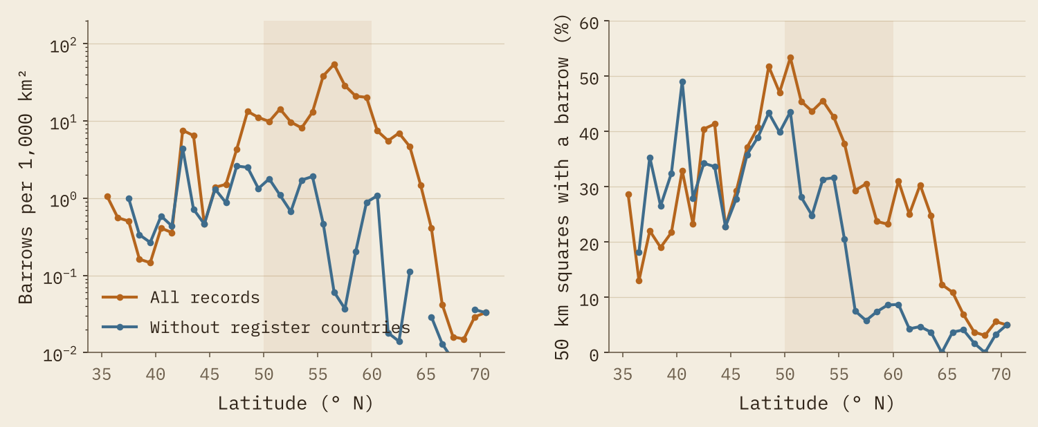
The map of Europe’s barrows is, first of all, a map of Europe’s heritage registers.
Earth or stone
So is there any pattern that does not depend on who did the counting? There is one, and I like it a lot. The same OpenStreetMap download also holds every mapped megalith: dolmens, passage graves, standing stones, stone circles. A keen mapper adds both mounds and stones, so for each country I can ask what share of its mapped prehistoric monuments are mounds. That ratio cancels out most of the effort.
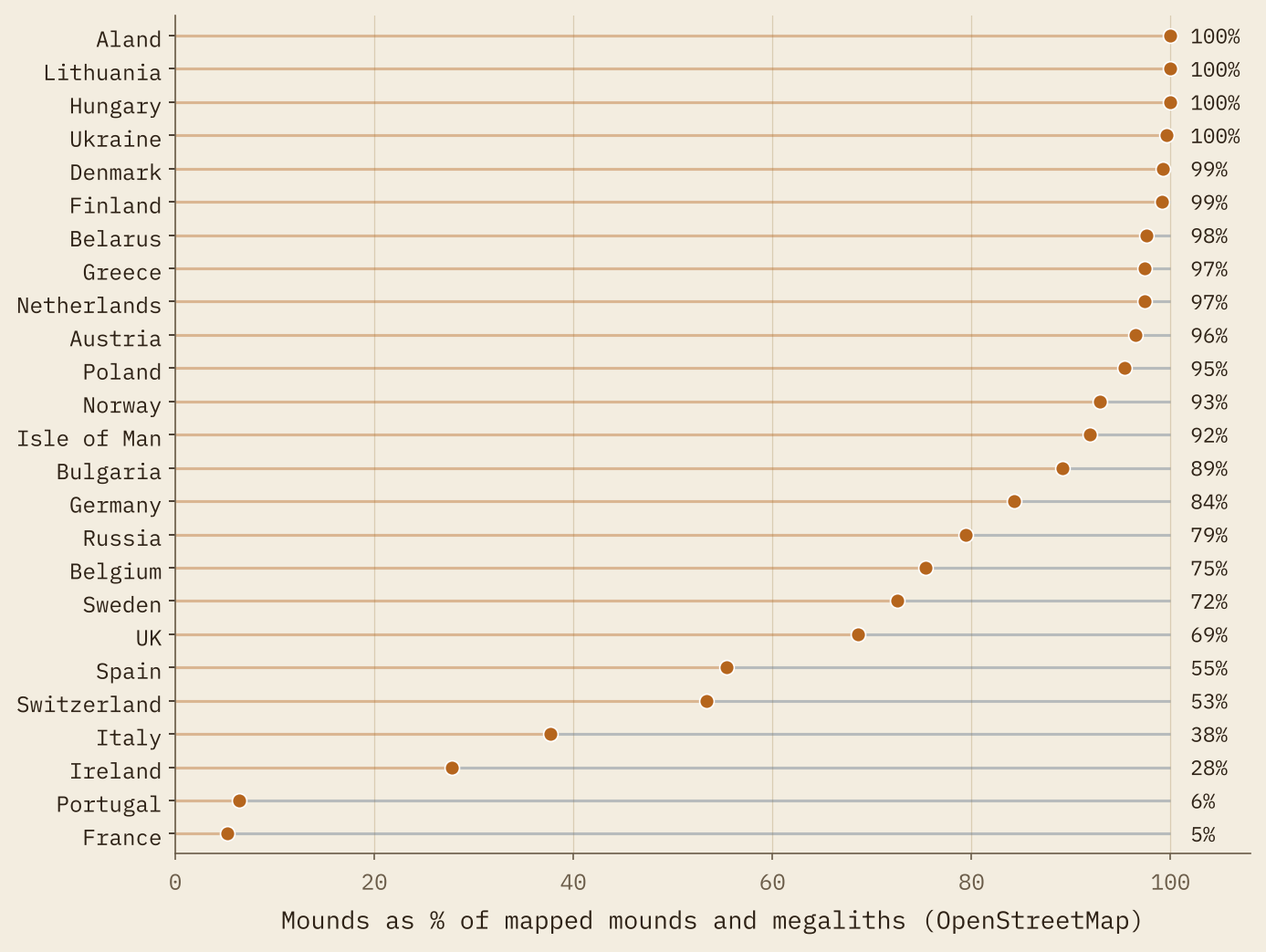
The Atlantic edge is stone country: mounds are only 5% of the mapped total in France, 6% in Portugal and 28% in Ireland. Across the North European Plain and east to the Black Sea it is almost all earth: 97% in the Netherlands, 95% in Poland, 100% in Hungary, 100% in Ukraine. Britain (69%) and Sweden (73%) have plenty of both. If there is a “barrow Europe”, it is not the north-west fringe. It is the great lowland belt from the North Sea to the steppe, with the megalith builders of the Atlantic on its western flank.
The other heartland, almost unmapped
The steppe ought to be the great exception. This is where the Yamnaya and their successors raised kurgans over their dead from the late fourth millennium BC. Yet in a box covering the Pontic and Caspian steppe I find just 2,587 mapped barrows, 2.2 per 1,000 km², 99.5% of them from OpenStreetMap. Wikidata has almost nothing for Russia or Ukraine, and 359 of the steppe records stand for a whole group of mounds (“kurgan group 1 near the village”), where a Danish register lists every mound separately. The data cannot tell us whether the steppe was the other heartland. They can tell us it is the part of Europe the open record misses most.
When were they built?
To date the tradition I used p3k14c, a big open database of radiocarbon dates, and kept the 489 dates from 132 sites whose names say barrow, tumulus, cairn, kurgan, høj, hög, Grabhügel or one of their cousins. I calibrated each date and weighted them so that every site counts once, however many samples it gave.
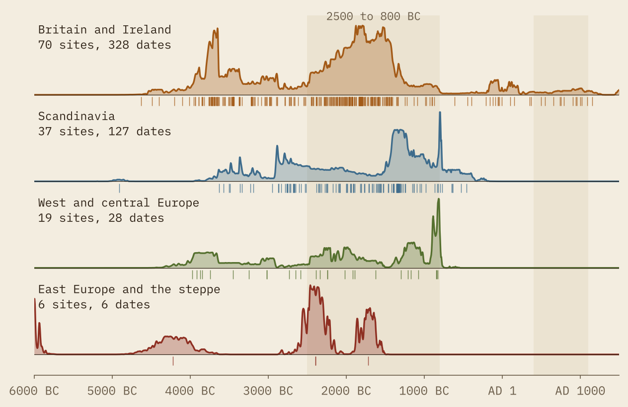
Two waves stand out. The first is Neolithic: 33% of the dates are older than 2500 BC, and in Britain the curve has its first peak around 3650 BC, the age of the long barrows. Barrows actually named as long barrows have a median date of 3640 BC. The second wave is bigger: 59% of the dates fall between 2500 and 800 BC, with Britain’s peak near 1790 BC, the age of the round barrows. Only 8% are later. Adding sites dated within 100 m of a mapped barrow gives the same picture.
Two caveats. The dated sites are mostly British (70) and Scandinavian (37), with only 6 in the east. And Iron Age and Viking mounds are usually dated by the brooches and swords buried in them, not by radiocarbon, so they are under-counted here.
So, is the barrow a European thing?
Yes, in the plain sense: there are mapped barrows from Ireland to the Urals, and the dated ones cluster in the Neolithic and above all the Bronze Age. A north-west European thing? The raw map shouts yes, but much of that shout is the sound of a few excellent national registers. The pattern that survives every test is broader and, to me, more interesting: an earthen mound tradition across the lowlands from the North Sea to the steppe, framed by stone tombs on the Atlantic coast, with a peak of building between about 2500 and 800 BC. It depends what you count, and who did the counting.
This post has two companions built from the same data: The Megalith Highway and a study of stone circles.
How I did this
From OpenStreetMap I took every object tagged as an archaeological tumulus or cairn, a tomb of type tumulus, or a long, round or chambered barrow or cairn: 47,664 after removing near-duplicates. From Wikidata I took every item of the classes tumulus and cairn (leaving out clearance cairns) and dropped those already in OpenStreetMap, by link or by lying within 30 m of an OpenStreetMap barrow, leaving 52,767. Countries and land areas come from Natural Earth; densities use an equal-area projection and 50 km squares. Radiocarbon dates come from p3k14c, linked by site name with exclusions for burnt mounds, towns called Barrow and other false friends, and calibrated with the IntCal20 curve. Every linked date and the rule that linked it is in the data files, as is every number in this post.
Notes and sources
- Barrows: © OpenStreetMap contributors (ODbL 1.0), queried through the QLever endpoint on 27 October 2026, and Wikidata (CC0).
- Radiocarbon dates: p3k14c, Bird and others (2022), Scientific Data 9, 27 (CC BY 4.0).
- Calibration: the IntCal20 curve, Reimer and others (2020), Radiocarbon 62(4), from the rintcal package.
- Countries and land: Natural Earth (public domain).
- Paper: Hotham, T. (2026) Is the Barrow a European Thing? Mapping and Dating Europe’s Burial Mounds. Zenodo. https://doi.org/10.5281/zenodo.23685258
- The barrow data are released under the ODbL 1.0; text and figures CC BY 4.0; code MIT.
- I wrote the text, with drafting and editing assistance from Claude (Anthropic), which also helped prepare the analysis code. I reviewed and checked all text and results.

