
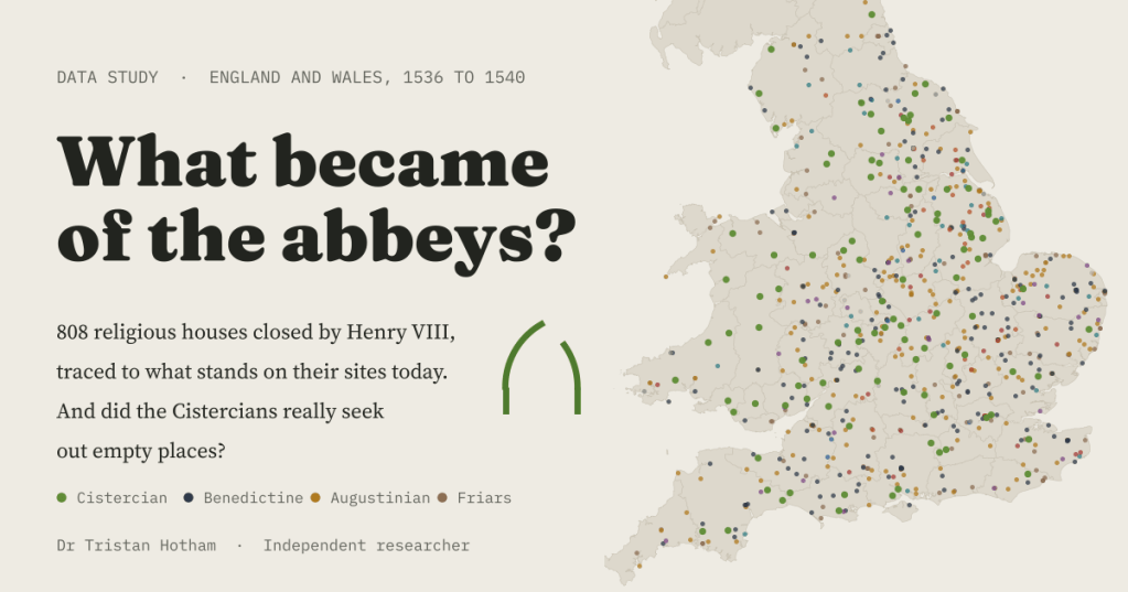
Henry VIII closed the monasteries of England and Wales between 1536 and 1540. I followed 808 of them to what stands on their sites today, and tested an old story about the Cistercians on the way.
Every ruined abbey comes with the same story. The king’s commissioners arrive, the monks sign the surrender, the lead is stripped from the roof and the stone is carted away to build somebody’s house. It is a good story, and you can stand inside it at Fountains or Tintern. But it is only the story of the ruins. I wanted to know what happened to all the others.
So I built a list. Wikipedia keeps a careful, county by county list of every monastic house in England and Wales, with a line or two on what became of each, and Wikidata adds coordinates and heritage listings. Together they give 808 houses closed between 1536 and 1540: 763 in England and 45 in Wales, abbeys, priories, nunneries, friaries and the houses of the Knights Hospitaller. I sorted every one by what the sources say is on the site now.
Four years, two waves
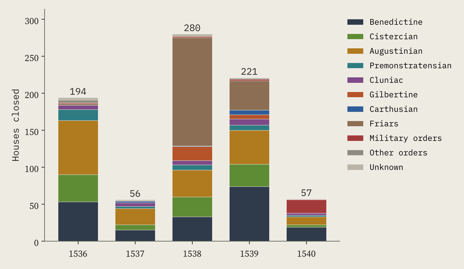
The small houses went first, under the Act of 1536: 194 houses in my list closed that year. Then came the surrenders. The busiest year was 1538, with 280 closures, because that was the year of the friars: 146 of the 189 friaries went in that one year. The great Benedictine abbeys followed in 1539, and the Hospitallers’ houses at the very end, in 1540.
Houses, churches, ruins, and nothing
For 499 houses the sources say clearly what is there today. The most common answer is not a ruin. It is a house: 122 sites (24%) have a mansion, manor house or other home built on or out of the monastery, some of them now hotels. Close behind come churches still in use, 109 of them (22%), where a nave or choir carried on as the parish church. 15 are cathedrals.
Ruins come third, at 78 sites (16%), and 82 sites (16%) have nothing visible left at all: car parks, shopping centres, railway stations, housing estates. Add it up and 81% of the sites with a known fate still have something standing.
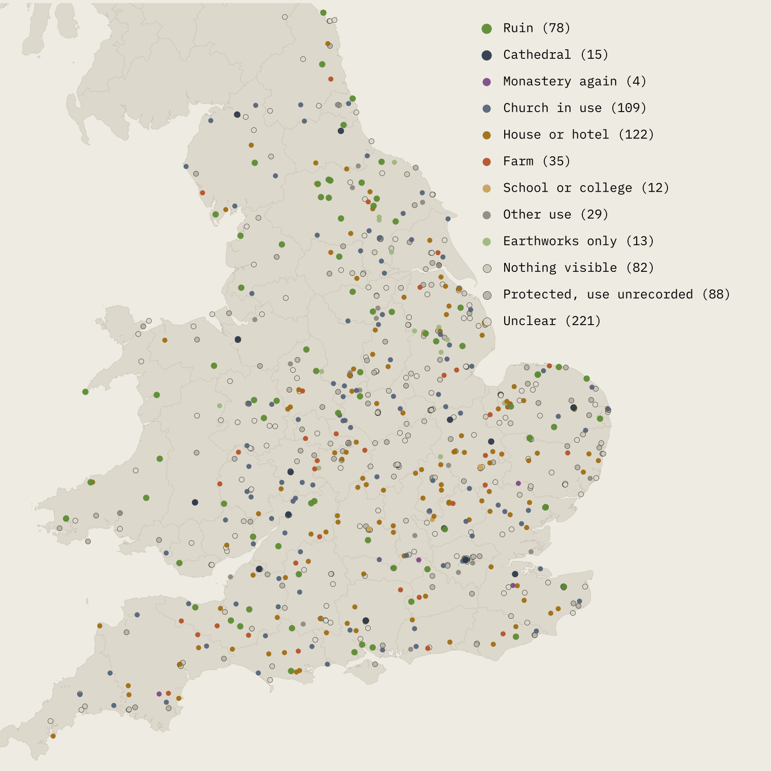
One honest caveat belongs here, not at the end. For 221 houses the lists say nothing at all about the present, and for 88 more the only clue is a listed building or scheduled monument. The shares above are shares of the houses whose fate is recorded.
Each order went its own way
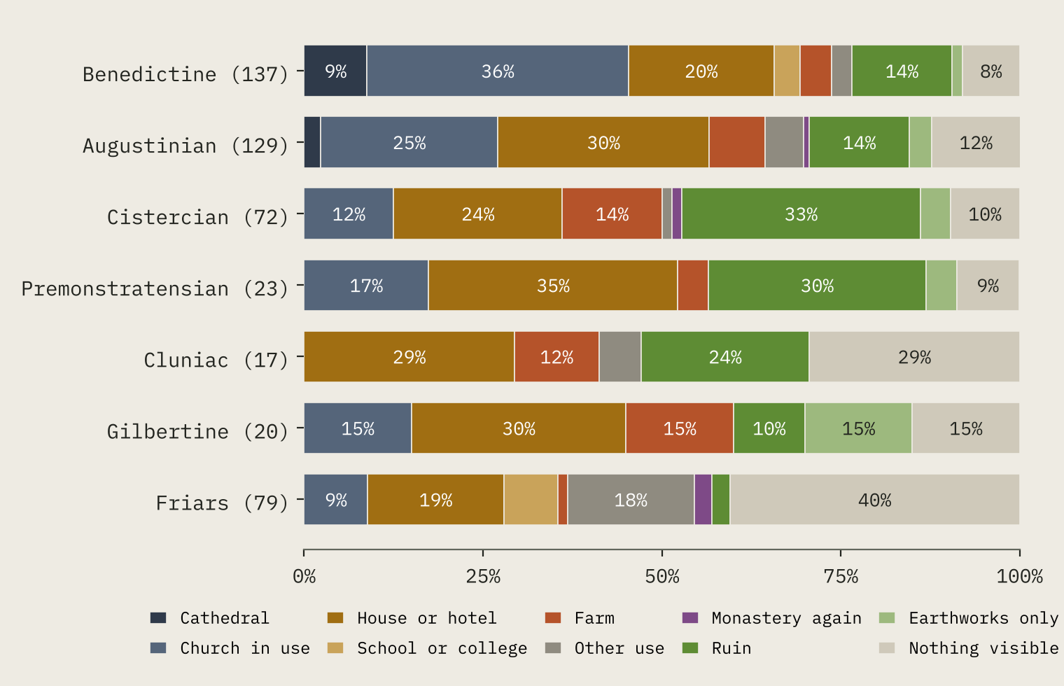
The fate of a house depended on who had lived in it. The Benedictines, the oldest order, often shared their great churches with a parish, and those churches were easiest to save: 36% of Benedictine sites with a known fate still have a church in use, and 9% are cathedrals. The Cistercians are the opposite. Their churches served no parish, and a third of their sites (33%) are ruins. The friars had built in the middle of towns, and towns grow over things: 40% of friary sites have nothing visible left.
And the new owners liked the old names. 39 of the 122 houses on monastic sites carry a monastic word in their name, 21 of them “Abbey”: Anglesey Abbey, Calke Abbey, Newstead Abbey, Mottisfont Abbey and the rest.
Did the Cistercians really seek the wilderness?
Every guidebook says it: the white monks wanted remote, empty valleys, far from other people. Domesday Book lets me test that. It records the households of thousands of English places in 1086, before the first Cistercian house in England was founded in 1128. For every monastery I added up the households recorded within 5 km, then ranked the site against 400 random spots in its own county, because some counties were far busier than others. A site at the 50th percentile was exactly as busy as an ordinary spot in its county.
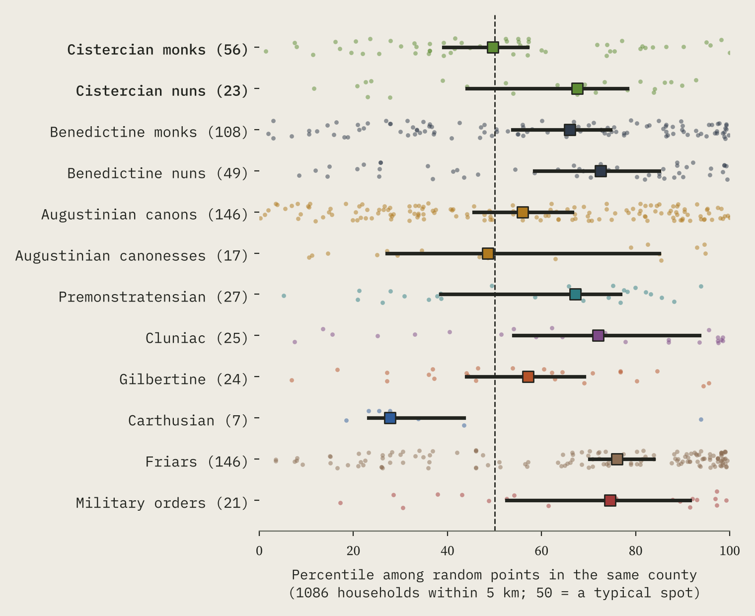
The typical Cistercian monastery stood at the 50th percentile. Benedictine monks stood at the 66th and the friars, who wanted towns, at the 76th. Comparing houses in the same county, Cistercian sites had about 27% fewer households nearby in 1086 than Benedictine ones.
The Cistercians did not find the wilderness. They found ordinary countryside, while everyone else was in the villages and towns.
What does set them apart is the ground. Their sites sit higher and in steeper country: the land within a kilometre rises and falls by 36 m around a typical Cistercian house, against 26 m for a Benedictine one, and in Wales the gap is wider still. The order with genuinely empty sites was a different one: the Carthusians, at the 28th percentile, though there are only seven of them to measure.
Close to home: Whalley and Sawley
Two Cistercian houses stood 11 km apart in the Ribble valley in Lancashire. Sawley, “a relatively poor establishment” as Wikipedia puts it, was closed in 1536, and that October the rebels of the Pilgrimage of Grace put its monks back in. Whalley’s abbot was executed for his part in events around the rising, and the abbey was taken in March 1537. Today Sawley is a ruin in English Heritage’s care, while Whalley, with its gateway and later house, is a retreat and conference house of the Diocese of Blackburn. Domesday Book names seven places within 5 km of Sawley: the valley was never empty.
How I did this
The houses come from the English Wikipedia county lists of monastic houses and the Welsh list, joined to Wikidata. I sorted each site’s present state with fixed rules applied to the list’s own words and marks, kept the deciding phrase for every house, and checked a random sample of 40 by hand (39 were consistent with their source). My 763 English houses are about 85% of the “nearly 900” religious houses Wikipedia gives for England. The 1086 households come from the Hull Domesday Project data, which leave out Wales, the far north, Lancashire, London and Winchester, so the Cistercian test covers 658 houses in the rest of England. Yorkshire, thinned by the harrying of the north, is a known weak spot: within Yorkshire the Cistercian and Benedictine sites look alike.
Notes and sources
- Houses: Wikipedia, List of monastic houses in England and its county lists, and List of monastic houses in Wales (CC BY-SA 4.0); Wikidata (CC0).
- Background: Wikipedia, Dissolution of the Monasteries, Cistercians, Whalley Abbey and Sawley Abbey.
- Domesday households: Hull Domesday Project, J.J.N. Palmer, George Slater and the University of Hull (CC BY-NC-SA), via realm-domesday, Open Domesday and my Domesday Destiny project.
- Terrain: AWS Terrain Tiles (Mapzen/Tilezen). Rivers and boundaries: OS Open Rivers and ONS (Open Government Licence v3).
- Paper, data and code: Zenodo and GitHub.
- I wrote the text, with drafting and editing assistance from Claude (Anthropic), which also helped prepare the analysis code. I reviewed and checked all text and results.

