
Stand on one hillfort in the Cheviots and you can often see the next. Did Iron Age builders plan it that way? I traced 169,271 lines of sight between Britain and Ireland’s 4,147 hillforts to find out.
There is an old and attractive idea about hillforts: that they were placed to see each other, so that a warning could pass by fire or smoke along a chain of hilltops. Walk the Scottish Borders or the Welsh Marches and it is easy to believe. Fort after fort has another in view.
The trouble is that hills see hills. If you put forts on high ground for any reason at all, they will see each other whether anyone planned it or not. So counting the forts in view proves very little. The real question is whether forts see each other more than similar ground nearby would. That is something I can test.
Most forts can see another
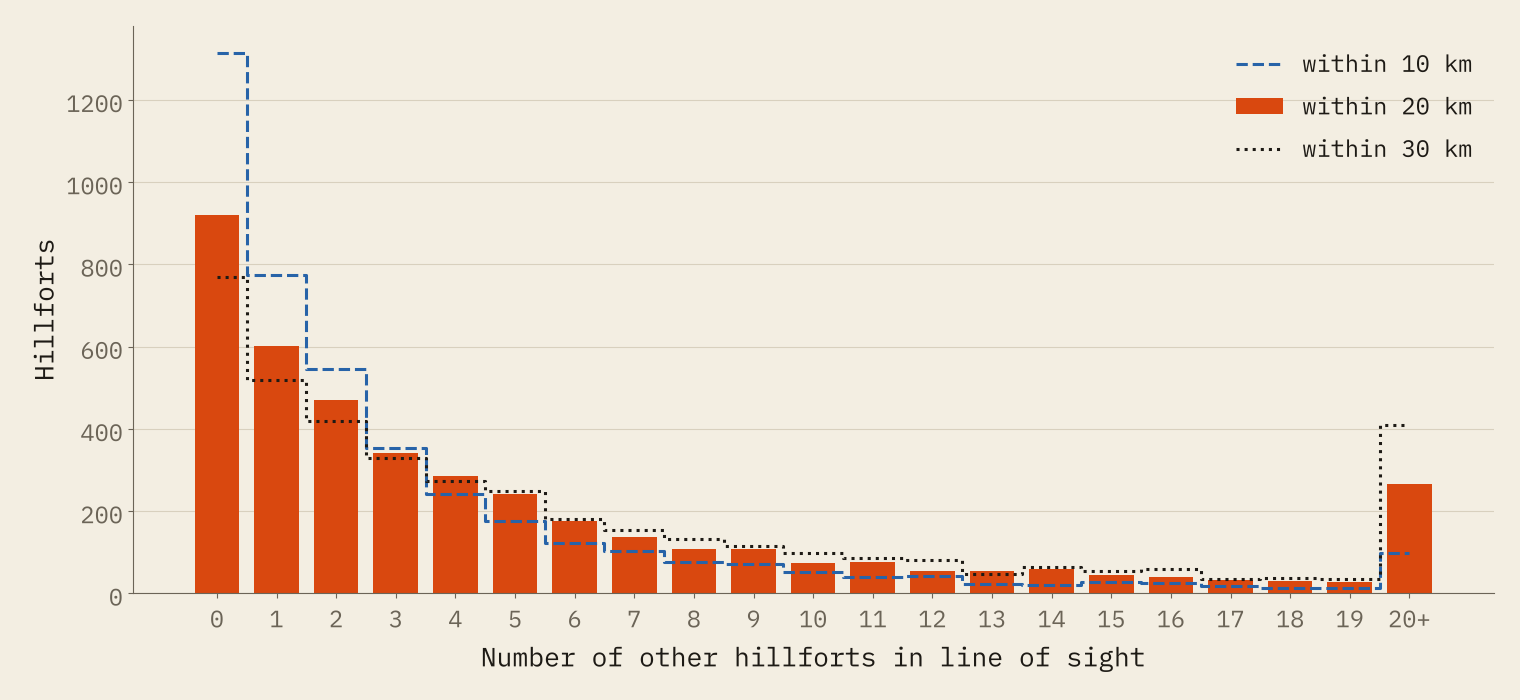
I took every hillfort in the Atlas of Hillforts of Britain and Ireland and checked whether a line from head height at one fort to head height at another clears the ground, allowing for the curve of the earth. Within 20 km, 12,386 of the 90,283 pairs of forts are in line of sight: 13.7%. More than three-quarters of all hillforts (78%) can see at least one other. Only 921 see none.
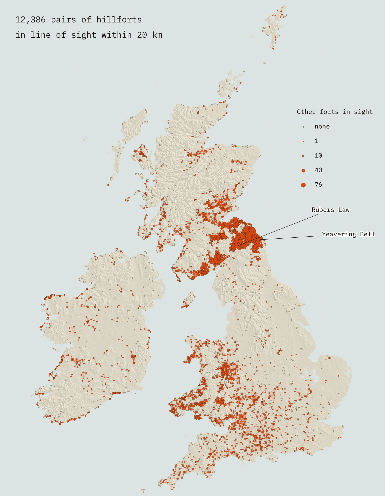
The champions are in the Tweed basin, on both sides of the border. Rubers Law in the Scottish Borders has 76 other hillforts in line of sight within 20 km. Yeavering Bell in Northumberland has 72. That is partly the view and partly the crowd: Yeavering Bell has 223 other forts within 20 km to look at. Some famous forts see very little. From its recorded point, Maiden Castle in Dorset has just 1 other hillfort in sight out of 16 within 20 km.
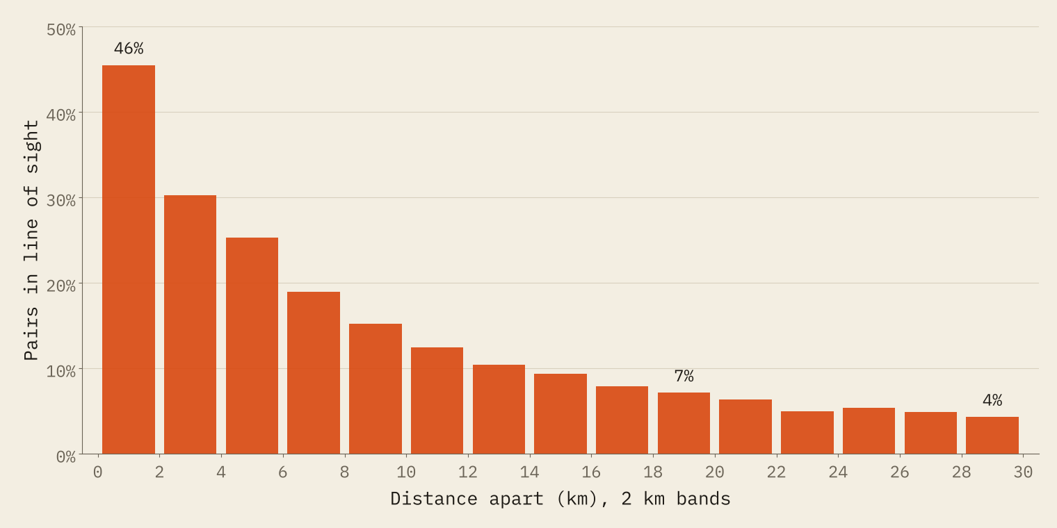
Distance matters a great deal. Of pairs less than 2 km apart, 46% are in line of sight. Of pairs 18 to 20 km apart, only 7% are.
A message from Flintshire to Devon
If fort A can see fort B, and B can see C, a signal could in principle pass from A to C. Joining up every visible pair turns the hillforts into networks. Within 20 km the largest has 950 forts and stretches 186 km across the Scottish Borders, Northumberland, the Lothians and beyond. The second largest, with 590 forts, runs from the Welsh borders down to Wessex and the south-west.
That second network gives the longest relay I found. A message passed fort to fort could travel from Glol Camp in Flintshire to Burleigh Dolts in Devon, 340 km apart in a straight line, in 36 hops.
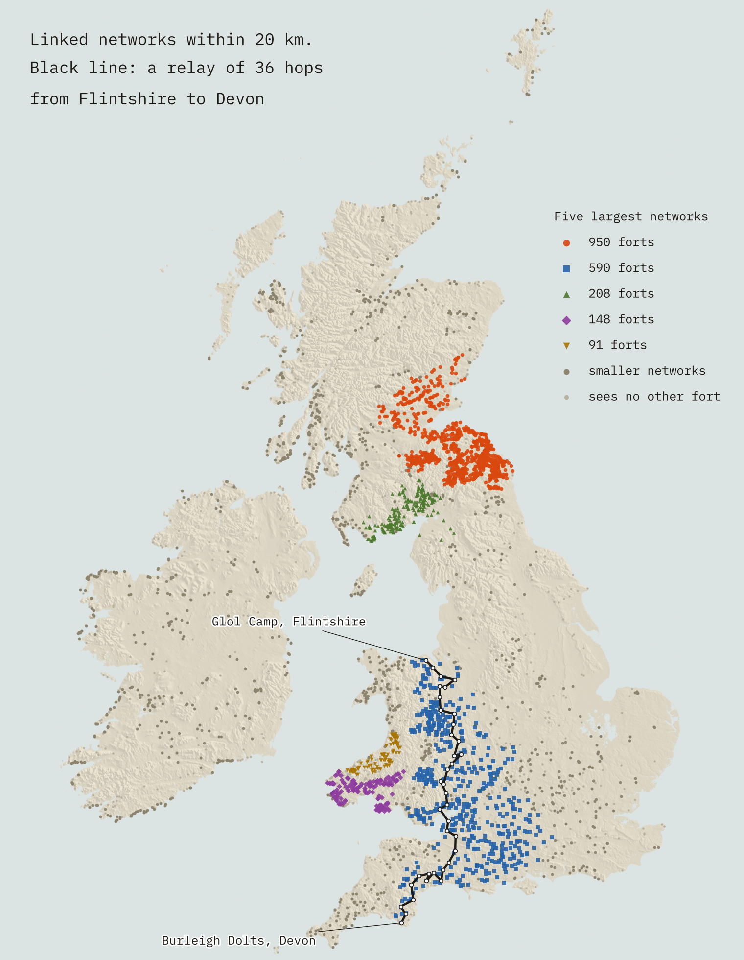
It is a lovely thought, but a chain on a map is not a chain in the past. Hillforts were built and used over more than a thousand years, mostly in the late Bronze Age and Iron Age, with some reused much later. A relay of 36 hops assumes every fort along it was standing and in use at once, and nobody knows which forts were.
Do they see more than hills do?
To test the signalling idea I needed a fair comparison. For each fort I drew 500 random points between 1 and 5 km away and kept the ones on similar ground: about as high, and holding a similar rank in height among the ground within 2 km. A fort on the highest ground around is matched to points that are also on the highest ground around. Then I built twenty shifted maps, each with every fort moved to one of its matches, and traced all the sight lines again.
The real forts win clearly. Within 20 km, 12,386 real pairs are in line of sight. The shifted maps average 9,104, and none of the twenty comes close. Real hillforts see each other about 36% more often than matched ground nearby, and the gap holds at 10 km and 30 km too.
So the siting was not random with respect to view. But that does not yet mean forts were placed to see each other. There is a simpler explanation: each fort was put somewhere with a good all-round view, and two places with good views are more likely to see each other.
Seeing far, or seeing each other?
To split the two, I ran a mixed test: a real fort looking at the shifted position of its neighbour. A real fort sees a shifted neighbour 11.7% of the time, against 10.1% for two shifted points. Apply that gain at both ends and you would expect 13.6% of real pairs to be in sight. The real figure is 13.7%.
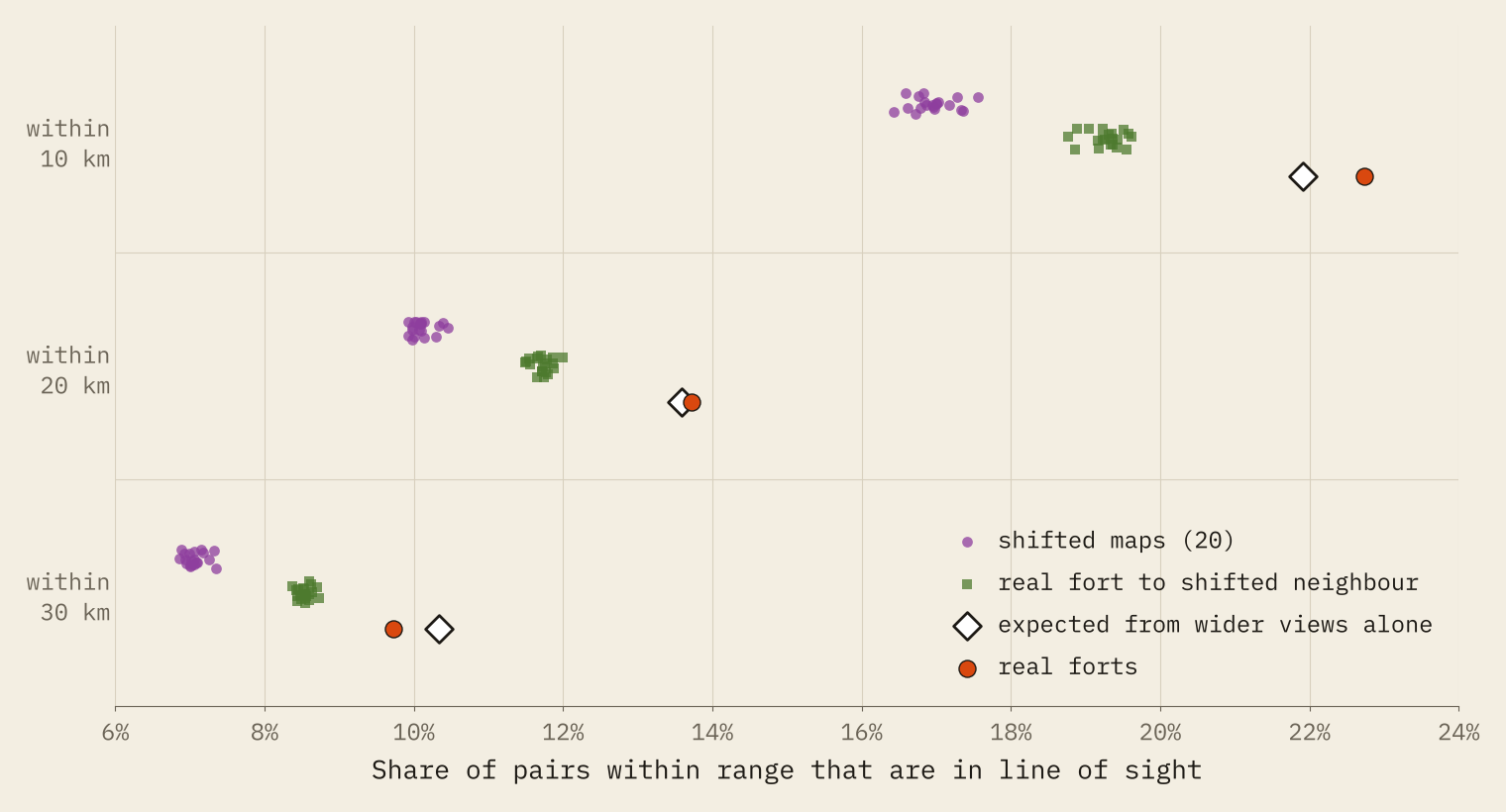
The extra intervisibility looks like a by-product of good views, not of forts aimed at each other.
Almost all of the extra comes from each fort having a wider view than the ground around it. At most there is a small extra between close neighbours: about 4% more pairs in sight within 10 km than good views alone predict. Within 30 km the real forts actually do slightly worse than the prediction. If forts had been placed to signal to distant neighbours, that is exactly where the extra should show up. It does not.
The big networks are not special either. The largest real network has 950 forts; the largest networks on the shifted maps have 744 to 951. Chains that long are simply what you get from this many forts on this kind of ground.
Height above the neighbours is what counts
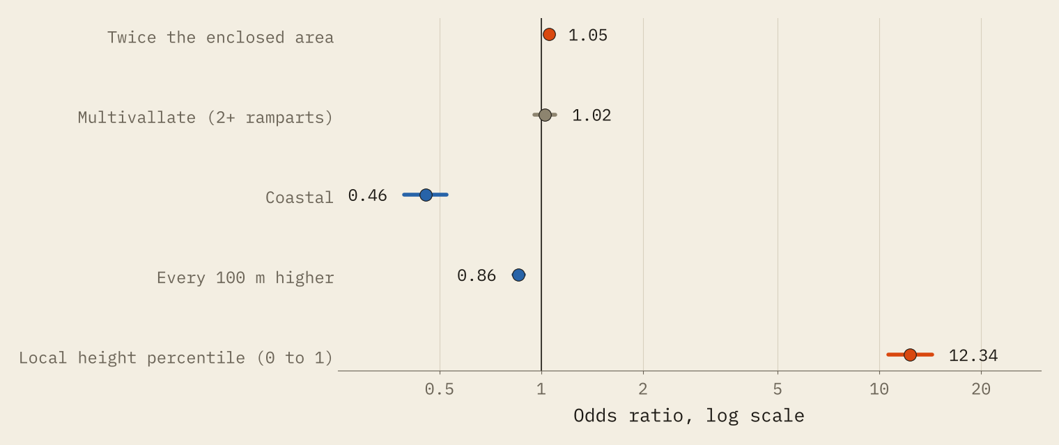
Which forts see the most? Raw counts favour forts with two or more ramparts, but they also have more neighbours. Once I allow for that, and for size, height and nation, the rampart difference disappears. The strongest factor by far is how high a fort sits compared with the ground within 2 km. Bigger forts see slightly more. Coastal forts see far fewer: only 49% of them can see any other hillfort within 20 km, against 84% inland.
Northumberland is in a class of its own: its forts average 23 others in sight, and 97% see at least one. At the bottom are mostly Atlantic edges such as Kerry, Donegal, Shetland and the Western Isles, where forts are few, often coastal and far apart.
How I did this
All 4,147 hillforts come from the Atlas of Hillforts of Britain and Ireland (Lock and Ralston 2017, CC BY-SA 4.0), via the copy of the source data released with Mike Middleton’s Hillforts Primer, as used in my earlier study The Famous Few. Ground heights come from the AWS Terrain Tiles, with pixels about 90 m across. For every pair of forts up to 30 km apart I sampled the ground every 45 m along the line between them, from 2 m above the ground at one fort to 2 m above the other, with earth curvature and standard refraction. I repeated it with 5 m eyes, and with each fort moved to the highest ground inside an area its own size. Both raise the numbers a little and change nothing in the story.
A line of sight is not the same as seeing a fort. It only means nothing solid is in the way. The ground model has no trees, smooths off summits, and the Atlas gives one point per fort, which is not necessarily the summit or the rampart. Some well-known pairs fail for that reason: British Camp and Midsummer Hill in the Malverns are blocked from their recorded points but visible once both are moved to their highest ground. A fire or a column of smoke would carry much further than the outline of a bank. And none of this rules out signalling in particular places or periods. It means the national pattern needs no signalling to explain it.
Notes and sources
- Site data: Lock, G. and Ralston, I. 2017, Atlas of Hillforts of Britain and Ireland (CC BY-SA 4.0), via Mike Middleton’s Hillforts Primer.
- Elevation: AWS Terrain Tiles by Mapzen and Tilezen (zoom 10), built from sources including SRTM, GMTED2010, ETOPO1 and national datasets (full attribution).
- Companion study: The Famous Few: size, fame and online attention to 4,147 hillforts.
- Paper, data and code: Zenodo and GitHub. Derived data and text are CC BY-SA 4.0; code is MIT.
- I wrote the text, with drafting and editing assistance from Claude (Anthropic), which also helped prepare the analysis code. I reviewed and checked all text and results.

