
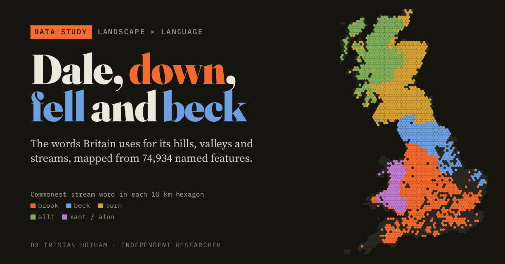
In Surrey a stream is a brook. In Yorkshire it is a beck. In Northumberland it is a burn. I mapped every named stream, valley and hill in Britain to find out where those lines fall, how sharp they are, and whether they follow the Vikings.
Walk north through England and the water changes its name. The hills change too: downs in Wessex, tors on Dartmoor, fells in the Lake District, laws in the Borders, bens and cnocs further north. These words are a fossil map of who named the land.
So I took every named valley, hill and waterfall in Ordnance Survey’s open map of place-names, and every named watercourse in its open river network, and sorted each one by its landscape word. Of 88,386 features, 74,934 (85%) carry a word I could recognise. I added 43,274 towns, villages and hamlets, checked for Norse endings such as -by, -thorpe and -thwaite.
Brook, beck, burn
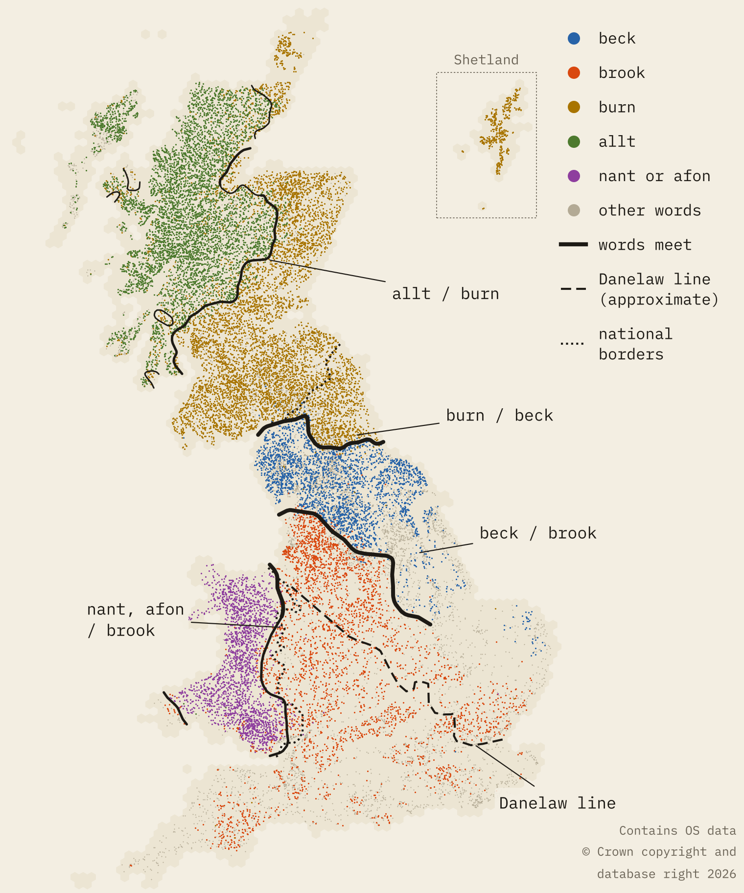
The streams draw the clearest lines in Britain. Ordnance Survey’s river data names 32,548 separate watercourses (I joined 105,905 short river links into single streams). 7,518 are burns, 5,924 are allts, 3,241 are brooks and 2,744 are becks.
Brook rules the south. Then, in a band no wider than a county, beck takes over. A little further north, burn takes over from beck. Walking north in 20 km steps, brook still has more than 80% of these three words at 53.6°N; 60 km further north, beck has 99%.
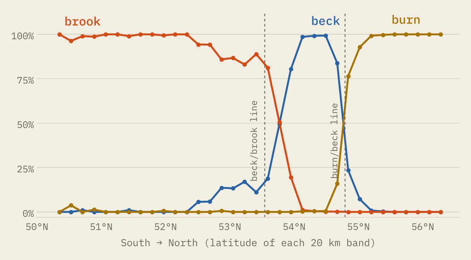
The beck/brook line runs for 262 km across northern England, through Lancashire, the south Pennines and Nottinghamshire to Lincolnshire. It is remarkably clean: 99% of becks lie on the beck side of it and 98.5% of brooks on the brook side.
How sharp is a line?
For each pair of neighbouring words I drew the line where they are equally common, then measured how far you have to travel across it for one word to go from 80% of the pair to 20%. A short distance means a sharp line.
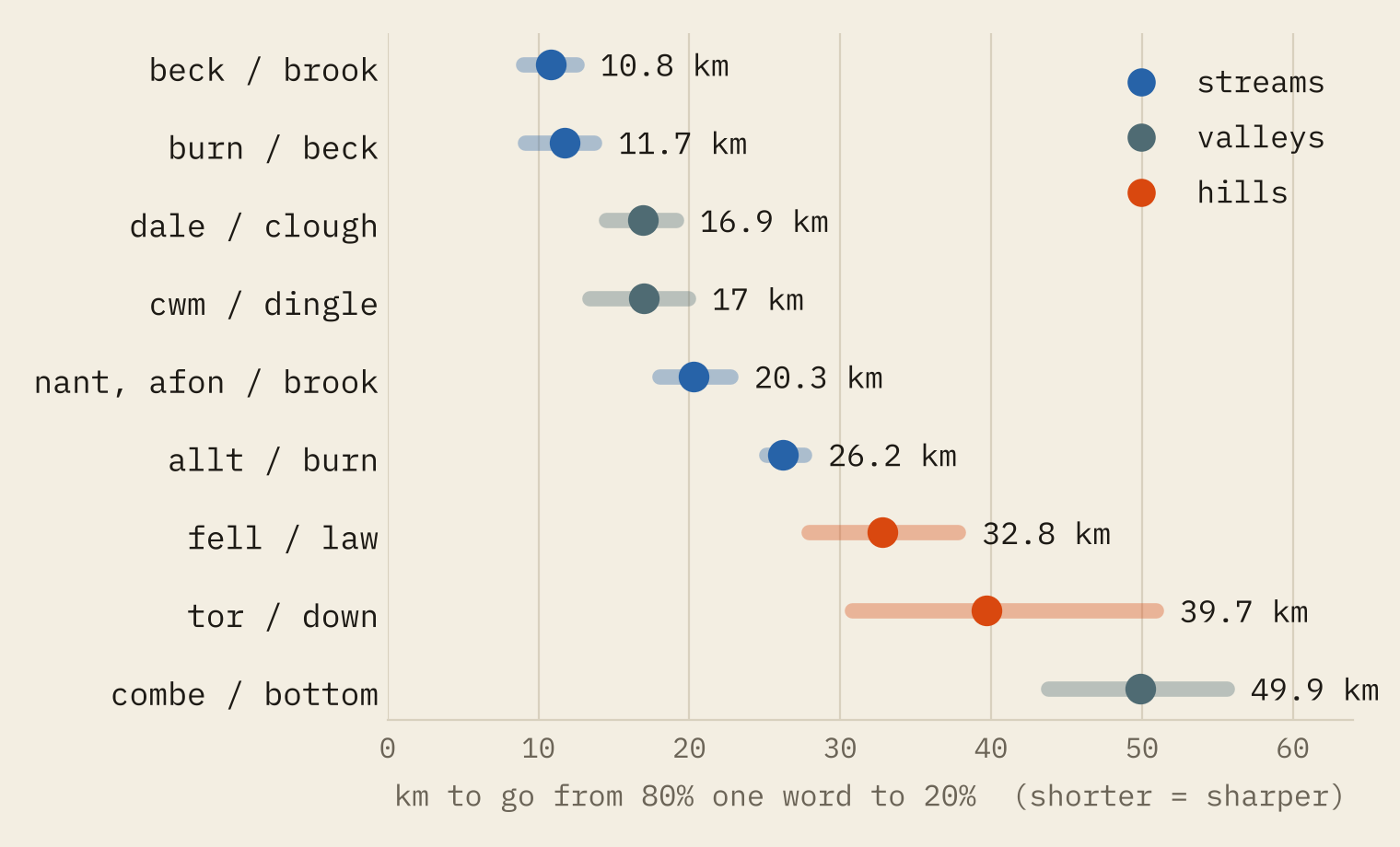
Beck gives way to brook in 10.8 km, and burn to beck in 11.7 km. That is about a day’s walk. Northumberland’s streams are burns, Yorkshire’s are becks, Derbyshire’s are brooks.
The valley words dale and clough meet across Yorkshire and the Peak in 16.9 km. The line between Scots burn and Gaelic allt is softer: it runs for 695 km through the Highlands and Argyll, and the change takes 26 km on average. The softest lines are where one word is rare. Combe and bottom blur over 50 km across the West Country, and tor and down mix over 40 km on the edge of Dartmoor.
Dale, down, hill and fell
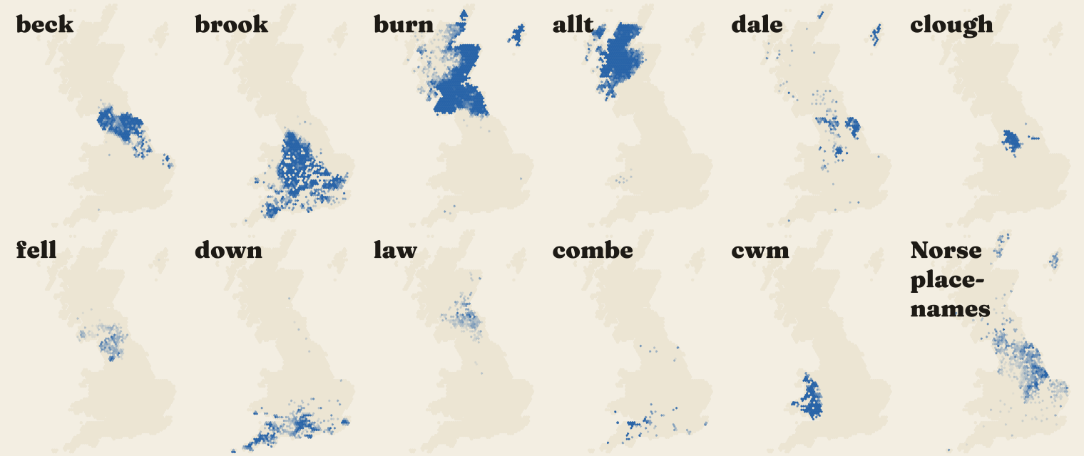
The valleys sort into neat bands. Bottoms fill Hampshire, Dorset and Wiltshire, combes Somerset and Devon, cloughs Lancashire and the south Pennines, dales Yorkshire, and cleughs the Borders and Dumfries and Galloway. Clough and cleugh are the same word in English and Scots spelling, and the dales sit between them.
Hills are different. Hill itself is everywhere: 20,259 of the 42,089 named hills are just hills. The local words are islands in that sea. Down (1,473) is southern England, fell (745) is Cumbria, the Pennines and Galloway, tor (142) is Devon and Cornwall, and law (483) is the Scottish Borders and Northumberland.
Some words are tiny local dialects. Every rife in the data is in West Sussex. Lincolnshire has 16 of the 17 eaus, a fenland name for a watercourse. In North Yorkshire a waterfall can be a foss; elsewhere in the north it is a force, from Old Norse fors.
Do the lines follow the Vikings?
Beck comes from Old Norse bekkr; brook and burn come from Old English brōc and burna. So the obvious test is Norse settlement. In every 10 km hexagon I took beck’s share of becks and brooks, and the share of towns and villages with a Norse element in their name. Across 626 English hexagons the two go together strongly, with a rank correlation of 0.63.
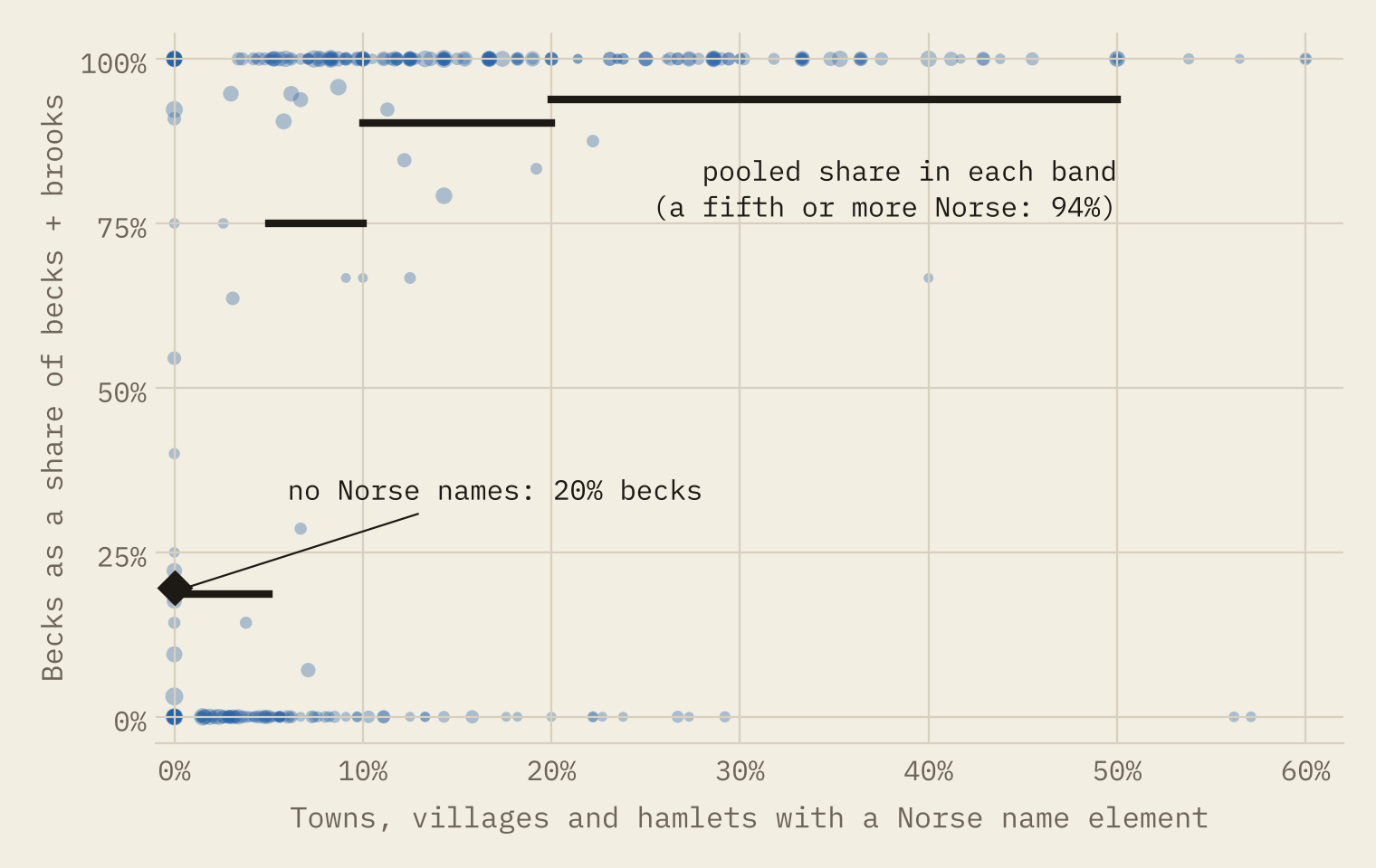
The link is strong but not one to one. Where no settlement has a Norse name, 20% of beck-or-brook streams are still becks. Where at least a fifth of settlements do, 94% are. On the beck side of the beck/brook line, 15% of settlements have a Norse element. On the brook side, 2%.
And the Danelaw?
The treaty between Alfred and Guthrum set a boundary up the Thames, up the Lea to its source, straight to Bedford, then up the Ouse to Watling Street. I drew an approximate version of that line and continued it along Watling Street and then straight to Chester. It is a sketch for orientation, not a surveyed frontier.
The beck/brook line does not follow it. The whole of the beck/brook line lies north of it, a median 84 km away and never closer than 53 km. In the Danelaw south of 53.2°N, brooks outnumber becks by 685 to 82.
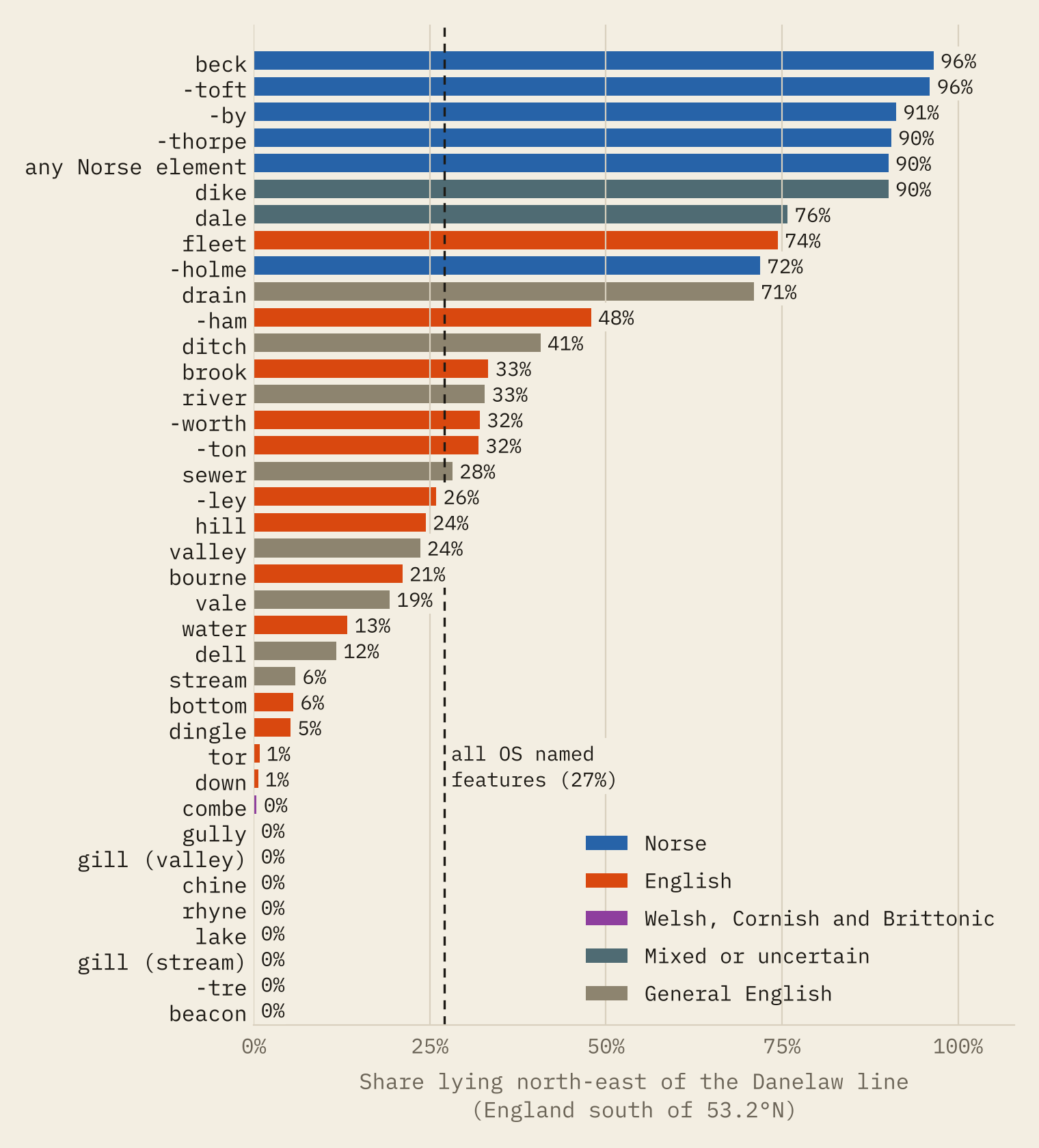
The settlement names are a different story. In the part of England the line actually crosses, south of 53.2°N, 27% of all named features lie on the Danelaw side. So do 90% of settlements with a Norse element, 91% of -by names and 90% of -thorpe names, against 32% of -ton names and 33% of brooks.
The Danelaw line separates the place-names. The stream names change much further north.
Even here the change is a gradient rather than a wall. In the 20 km strip just south-west of the line, 0.9% of settlements have a Norse element; in the strip just north-east, 2.8%; and 11.4% at 60 to 80 km in. Becks only appear in numbers more than 60 km into the Danelaw, in Lincolnshire and Norfolk.
Wales stops at the border, Scotland does not
The Welsh words stop almost exactly at the Welsh border. The line between nant or afon and brook runs a median 10.6 km from it, and 81% of the line lies within 20 km. The cwm/dingle line is a median 6.4 km from the border.
The Scottish border is not a word boundary at all. The burn/beck line runs a median 40 km inside England, through County Durham and northern Cumbria. The words of the Borders belong to both countries.
My favourite oddity: the most Norse place in England on my measure is Applethwaite, near Keswick, with 151 Norse-linked words and 1 English one within 10 km. The least Norse is Tintwistle, high in the Peak, with 102 cloughs and 45 brooks around it and not one beck. It is only 18.9 km from the beck/brook line.
How I did this
Hills, valleys, waterfalls and settlements come from OS Open Names, and streams from OS Open Rivers, both free from Ordnance Survey. Each name gets at most one landscape word, its generic: Mill Beck, Afon Conwy, Cwm Idwal, Troutbeck. The rules are published regular expressions. I read 150 random matches and found none wrong, and a second check of 120 matches of rarer words found none wrong and one uncertain, but some errors will remain.
The boundaries come from smoothing each word’s map and drawing the line where two words are equally common. Sharpness is the 80% to 20% distance from a logistic fit across the line, with bootstrap intervals. The Danelaw line is hand-placed and approximate.
One caution runs through all of this. Ordnance Survey’s map is a modern map, not a historical record. Many names are recent: drains cut in the fens, farm-named hills, cloughs named after the mill above them. A name on the map tells us what a place is called now, not when it was first named. The patterns are still striking, because local words for landscape are exactly the kind of thing new names inherit from old ones.
Notes and sources
- Named features: Ordnance Survey, OS Open Names.
- Watercourses: Ordnance Survey, OS Open Rivers.
- Contains OS data © Crown copyright and database right 2026, used under the Open Government Licence v3.0.
- Paper, data and code: Zenodo and GitHub. Derived data and text CC BY 4.0, code MIT.
- I wrote the text, with drafting and editing assistance from Claude (Anthropic), which also helped prepare the analysis code. I reviewed and checked all text and results.

