
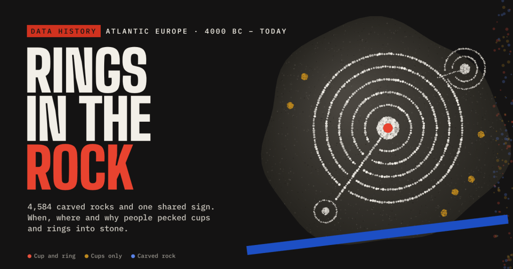
Thousands of stones along Europe’s Atlantic edge carry the same pecked sign: a cup, a set of rings and a channel running out. Here is what the records say about when, where and why.
Walk up onto Ilkley Moor and you will find the Badger Stone, a gritstone boulder covered in cups and rings. Go to Marín on the Galician coast and you will find the Mogor stones, granite outcrops carved with rings and labyrinths. The two places are 1,200 kilometres apart, with the Bay of Biscay between them, and they share a visual language.
This post pulls together the open records that now exist for these carvings: Scotland’s Canmore register, Ireland’s national rock-art layer, and Wikidata and OpenStreetMap for England, Galicia, Portugal and Brittany, plus the published counts and dates for each region. Then it asks the three questions everyone asks: how old are they, why are they where they are, and what were they for. At the end I set out my own reading of the evidence.
The full interactive version, with a zoomable map of every rock, a carving you can build yourself and a live ripple simulation, is on its own page.
What a cup and ring is
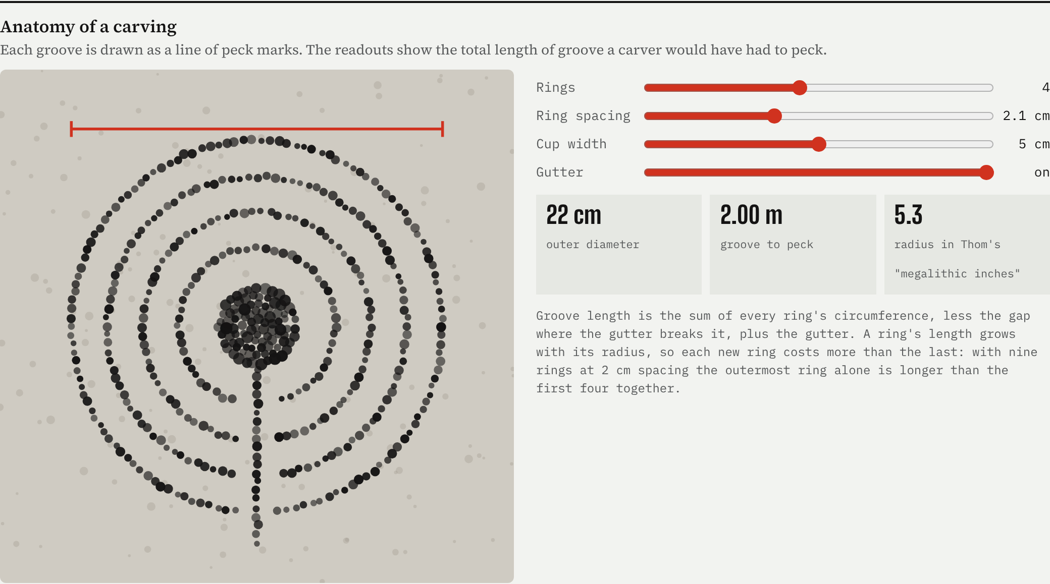
The basic mark is a cup: a shallow hollow, usually 2 to 6 centimetres across, pecked into rock with a harder hammer stone. Around some cups the carver added one or more rings, sometimes broken by a straight groove, the gutter, that runs from the centre out past the rings. Scotland’s Rock Art Project counts nine rings around one cup at Castleton. Most carvings are simpler: in Scotland’s register there are two cup-only rocks for every one with rings.
How old are they?
Rock carvings are hard to date. You cannot radiocarbon-date a pecked groove, so archaeologists date what touches it: a cairn built over a carved stone, a broken slab reused in a tomb, charcoal in the soil around an outcrop, or a carved weapon whose metal type is known. Each gives a “no later than” or “around the same time as” date, not a birth certificate.
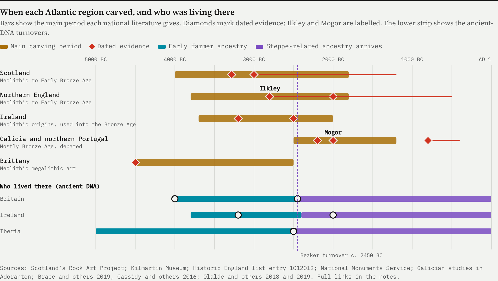
Put the national evidence side by side and a sequence appears. Brittany’s carved megalithic tombs and standing stones are among the oldest, from the fifth and fourth millennia BC. Britain and Ireland follow from about 4000 to 3700 BC, with the open-air rocks mostly Late Neolithic and Early Bronze Age. Historic England dates the Rombalds Moor carvings around Ilkley to about 2800 to 500 BC. Galicia and northern Portugal come later: most of their open-air art, Mogor included, is placed in the Late Neolithic and Bronze Age, and some researchers push part of it into the Iron Age.
The rings outlived the people who first carved them.
The lower strip of that chart matters. The first farmers reached Britain around 4000 BC with ancestry that traces back, through the Mediterranean and the Atlantic coast, to Anatolia and the Aegean. Around 2450 BC, with the Beaker culture, about nine-tenths of Britain’s gene pool was replaced within a few centuries by people carrying steppe-related ancestry. In Iberia the same arrival around 2500 BC replaced about 40% of the ancestry and nearly all the male lines by 2000 BC.
The carvings did not stop. In Britain people went on carving, and reusing carved stones in burial cairns, well into the Bronze Age. In Galicia the main period of open-air carving comes after the steppe arrival. Whatever the rings meant, they were not tied to one bloodline. They were tied to places, and new people picked them up.
Where they are
The map folds the seaboard so both ends fit in one frame: Britain and Ireland on the left, Brittany, Galicia and northern Portugal on the right, at the same scale. Every dot is a carved rock from an open register: 2,845 Scottish records from Canmore, 826 Irish records from the National Monuments Service, and Wikidata and OpenStreetMap for the rest.
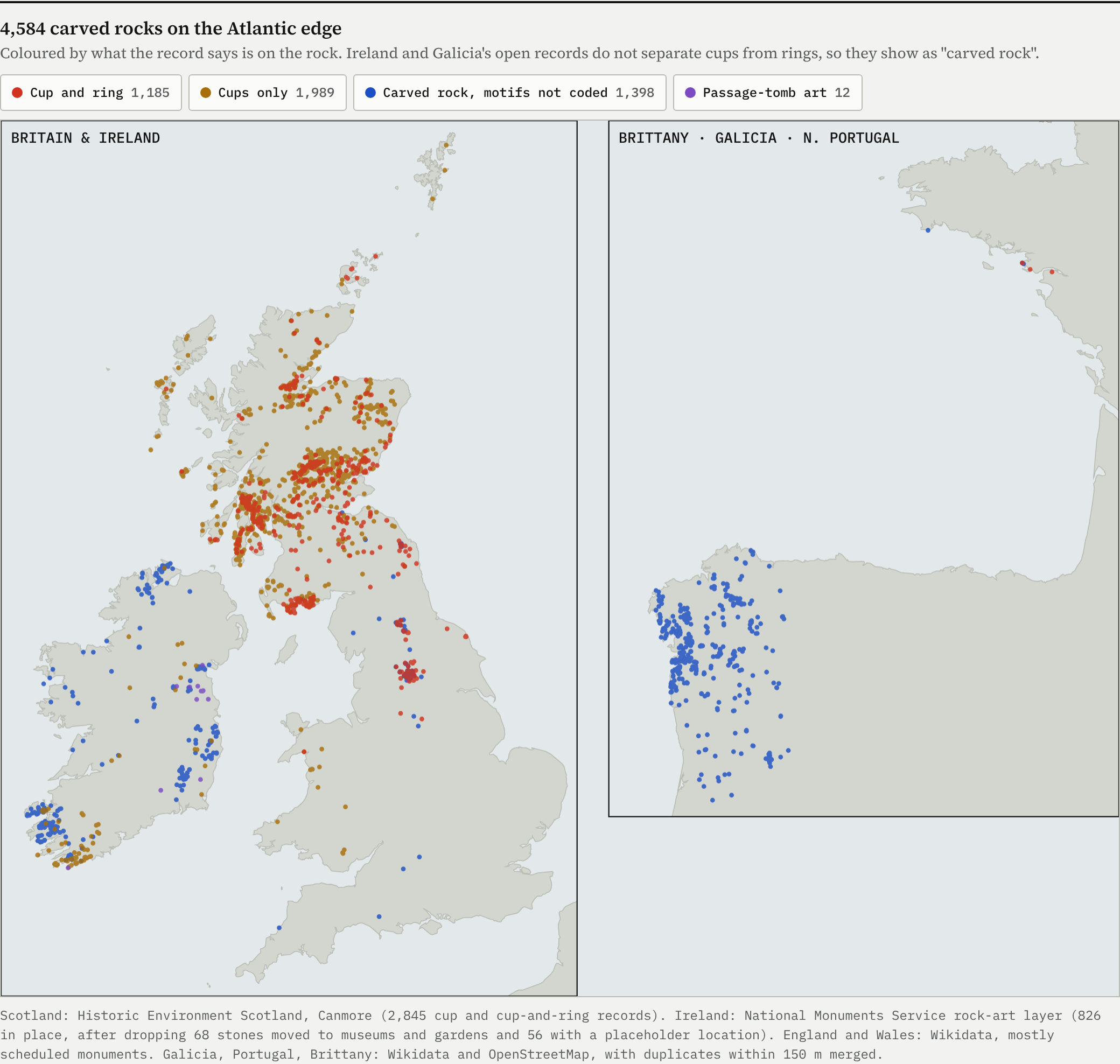
The clusters jump out: Argyll and Perthshire in Scotland, the Iveragh peninsula in Kerry and Inishowen in Donegal, the Pennine moors around Ilkley, and the Pontevedra coast in Galicia. Argyll and Bute alone holds 730 of Canmore’s records, most of them around Kilmartin Glen.
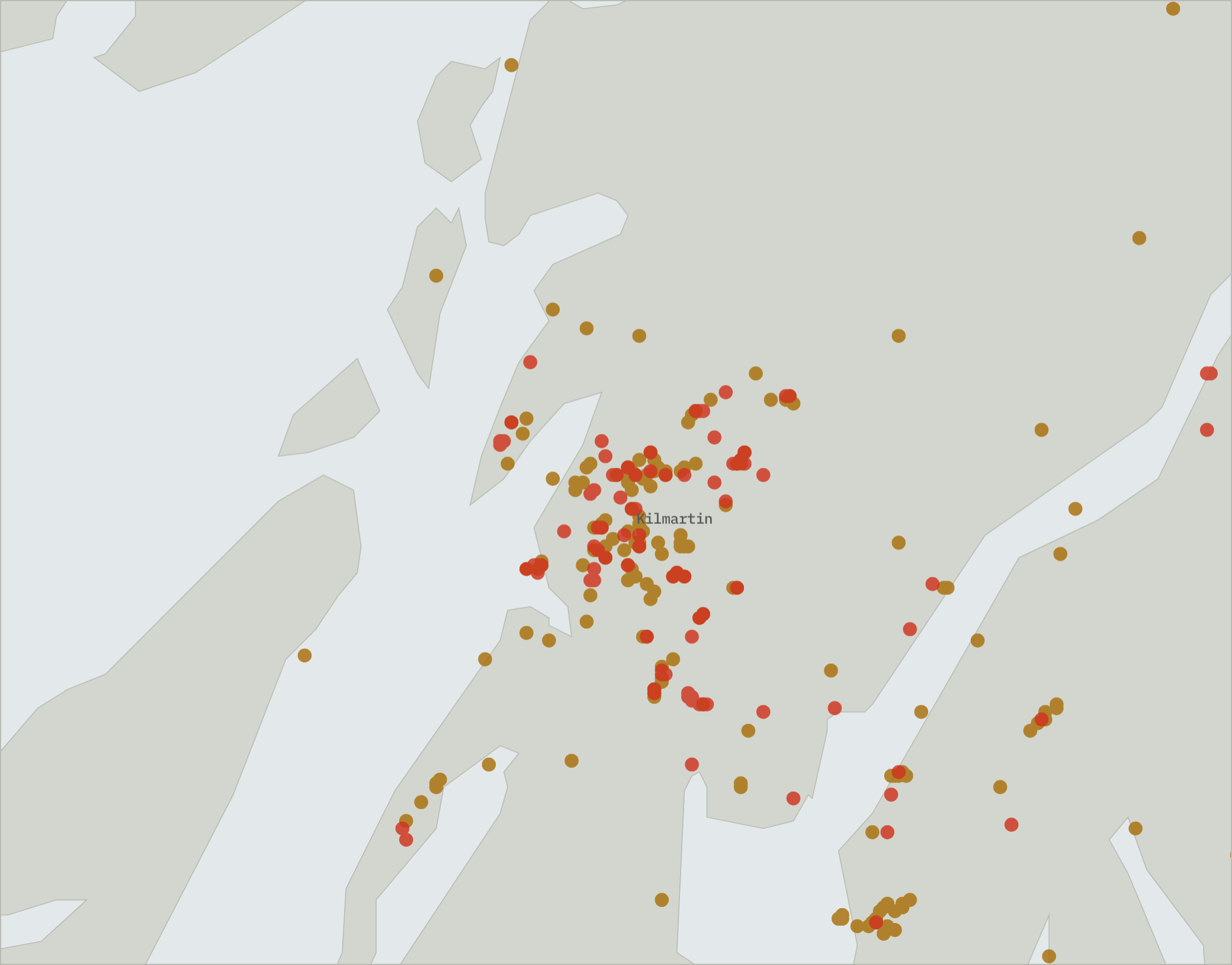
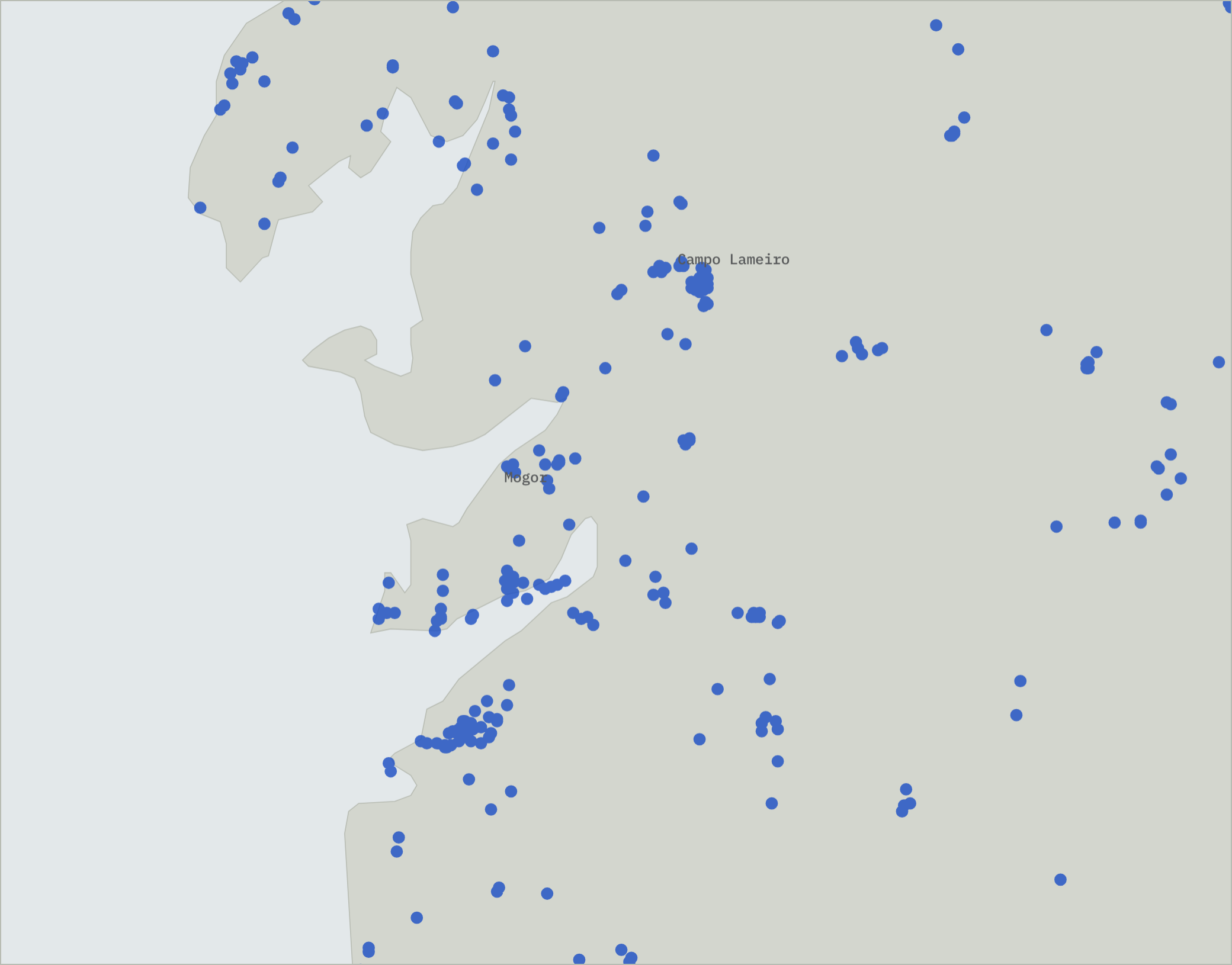
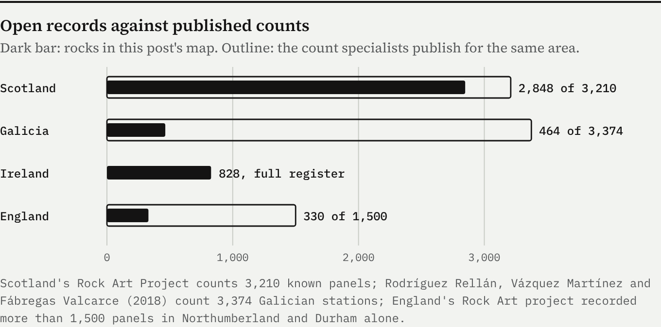
Some of the gaps are gaps in recording, not in carving. Scotland’s register is nearly complete, Ireland’s full national layer is mapped, but Galicia’s open data shows only about one rock in seven and England’s covers mainly scheduled monuments. Treat the densities as minimums.
What is on the rocks
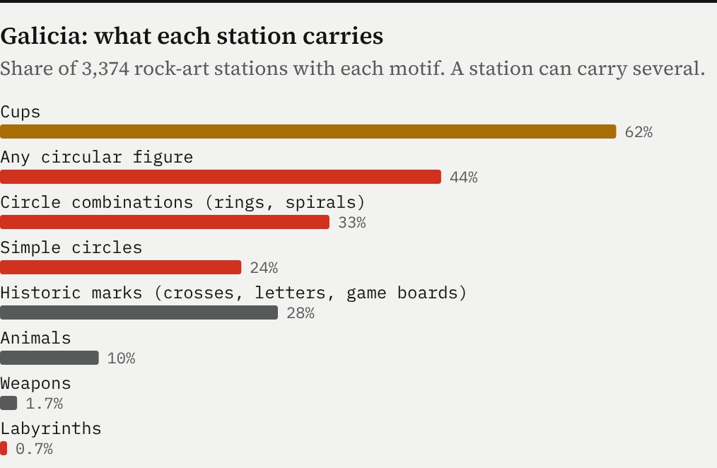
Cups are everywhere; rings are the special case. In Scotland a third of the records have rings. In Galicia, a 2018 study of 3,374 stations found cups at 62% of them and circular figures at 44%, with animals, weapons and labyrinths far behind. Mogor’s labyrinths belong to a motif found at just 24 Galician stations, less than 1%.
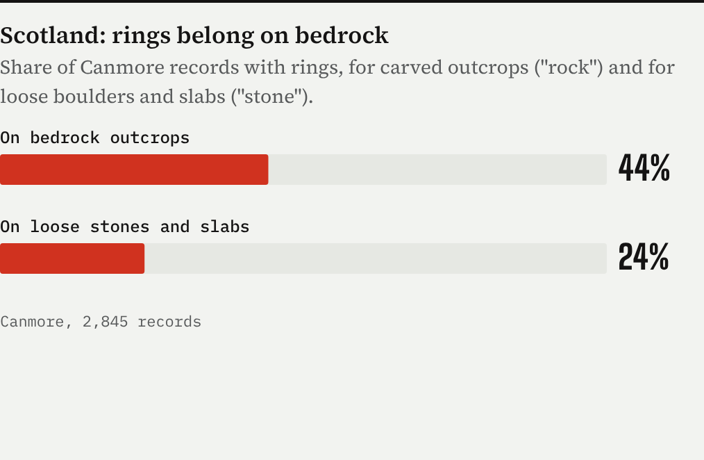
The Scottish records hold a small, checkable clue. On fixed outcrops, 44% of records have rings. On loose boulders and slabs it is 24%. Rings were carved more often on rock that could not be moved, which suggests the ringed sign was about a place.
Drawn to the sea
If the motif travelled along the Atlantic by boat, as farming did, you would expect it to cling to the coast. I tested that directly. For each mapped rock I measured the distance to the nearest coastline and compared it with 4,000 random points on land in the same region.
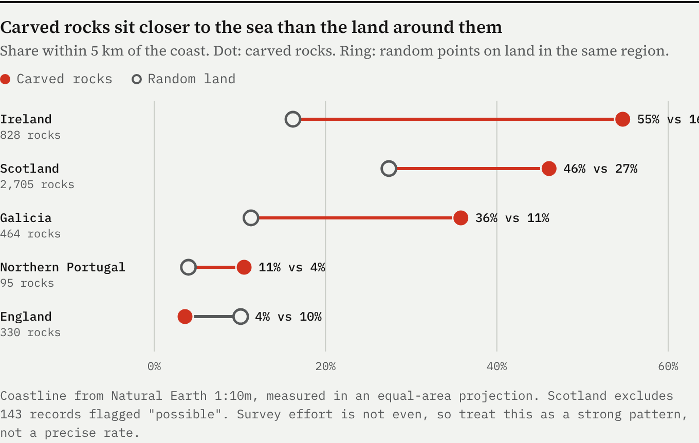
The western heartlands are strongly coastal. In Ireland 55% of rock art lies within 5 km of the sea, against 16% of the island’s land. Galicia shows the same pull, and so does Scotland. England is the exception: its carvings are on the Pennine and Northumbrian moors, far from salt water. That fits a picture in which the sign arrived by sea in the west and then moved inland along upland routes. Survey effort is uneven, so treat this as a strong pattern, not a precise rate.
The maths of a ring
Why concentric circles, of all shapes? There are three good mathematical answers.
1. A ring is the cheapest perfect shape
A circle is the only curve you can make by keeping one distance fixed. Pin a cord at the cup, hold a pointed stone at the other end, and the circle draws itself. Add another knot and you get the next ring. The shape needs no plan, just a fixed centre and a cord, which is why concentric rings turn up wherever people peck rock.
2. They are not frozen ripples
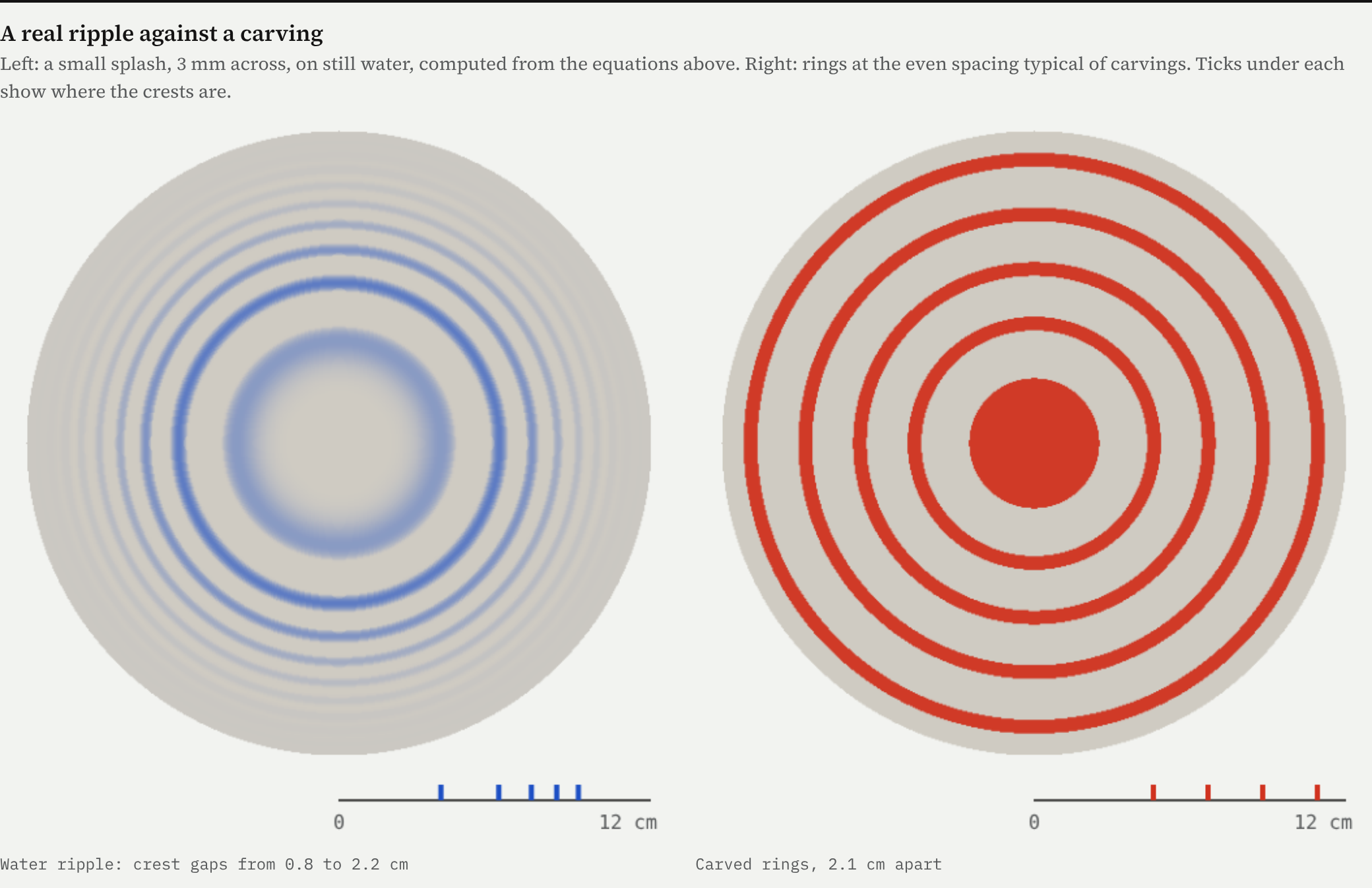
The commonest folk explanation is ripples on water. The physics says no. Waves on water spread at different speeds depending on their length (the dispersion relation ω² = gk + (σ/ρ)k³), so the rings from a dropped pebble are never evenly spaced: the pattern stretches as it travels and the gap between crests changes from front to back. Carved rings are evenly spaced.
3. Your eye makes rings
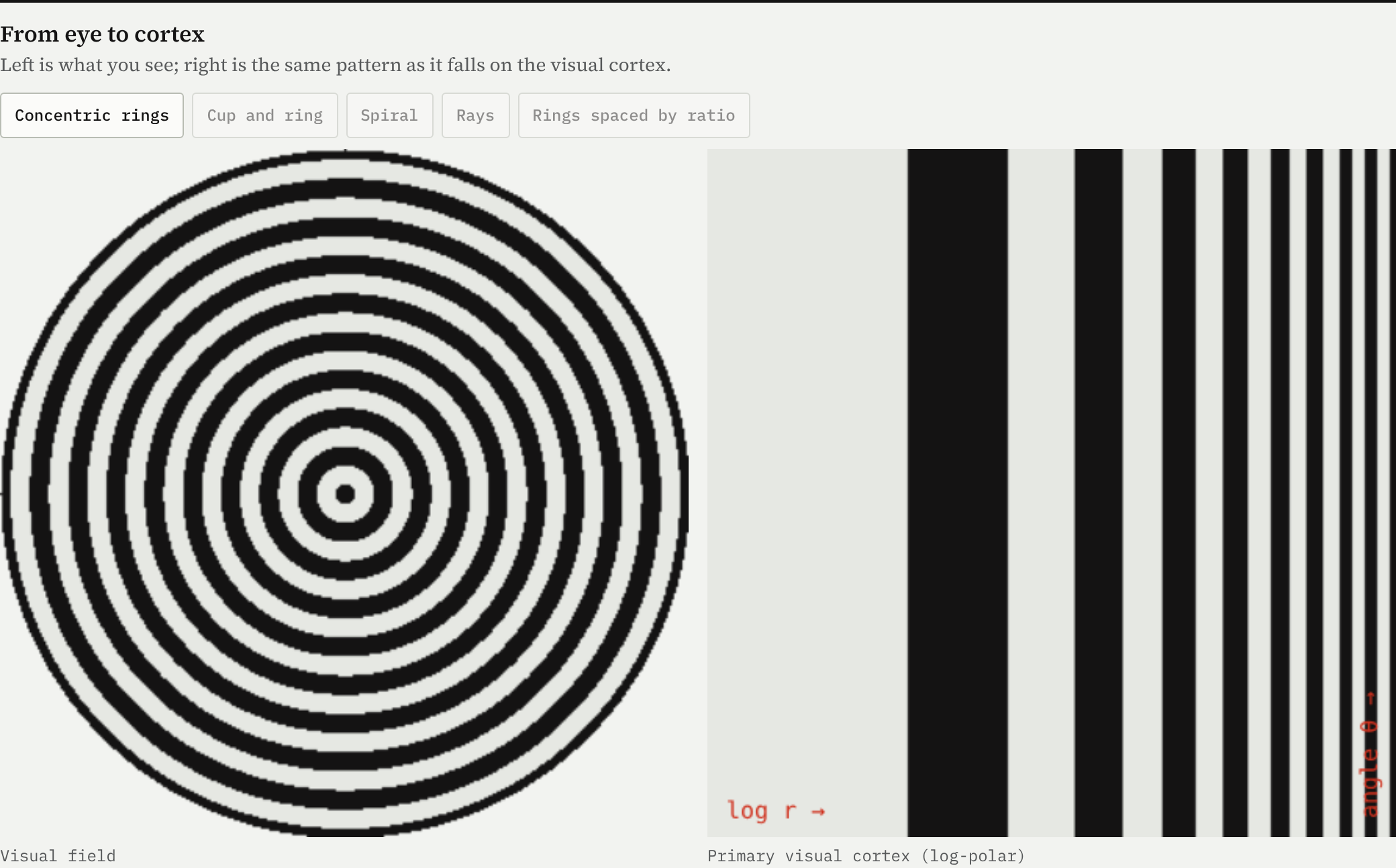
The deepest answer may be inside the head. In 1926 Heinrich Klüver noticed that people under the influence of mescaline see the same few geometric forms: lattices, cobwebs, tunnels and spirals. Later work showed why. The map from the retina to the primary visual cortex is close to a complex logarithm, w = log z: a point at distance r and angle θ from the centre of gaze lands at (log r, θ) on the cortex. Under that map concentric rings become parallel stripes, the simplest pattern a sheet of nerve cells falls into when it is overexcited.
David Lewis-Williams and Thomas Dowson built this into a theory of rock art in 1988: geometric signs record trance visions. You do not need trance for the maths to matter, though. Rings are a shape the human visual system is built to find striking, which helps explain why they appear on every inhabited continent.
One more number with a famous history. Alexander Thom argued that the carvers used a standard unit, the “megalithic inch” of 2.07 cm. A later test on English carvings by Alan Davis found the evidence weak and not statistically significant. Even spacing does not need a standard unit; a hand or a finger width will do.
A world motif
The Atlantic carvings are one regional chapter of something much older and wider. Cupules, the simplest pecked hollows, are found on every continent except Antarctica, and some may be among the oldest marks humans ever made: one sequence on the edge of the Kalahari has been suggested at about 410,000 years old, and the Daraki-Chattan rock shelter in India carries more than 500 Lower Palaeolithic cupules. Concentric circles appear in the Alps, Sardinia, the Levant, Hawaii and the Americas.
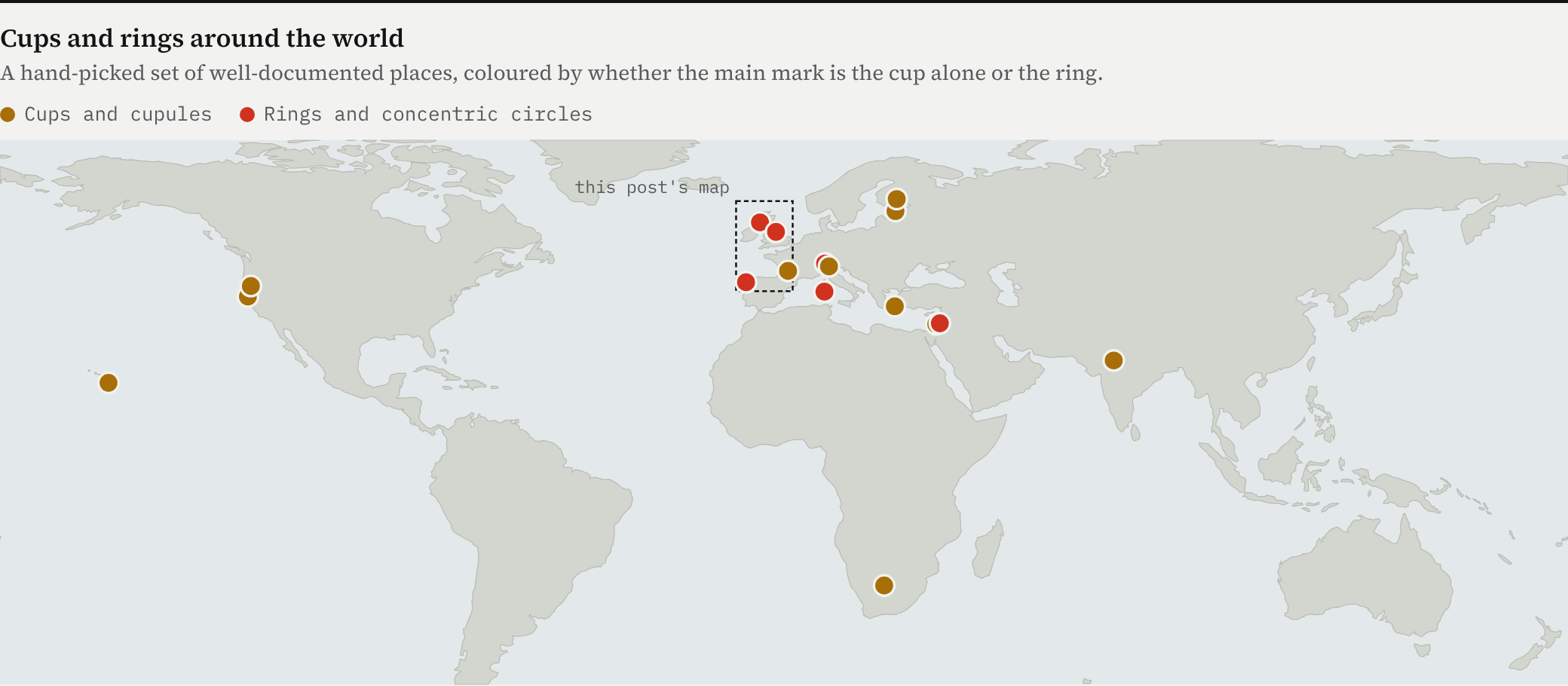
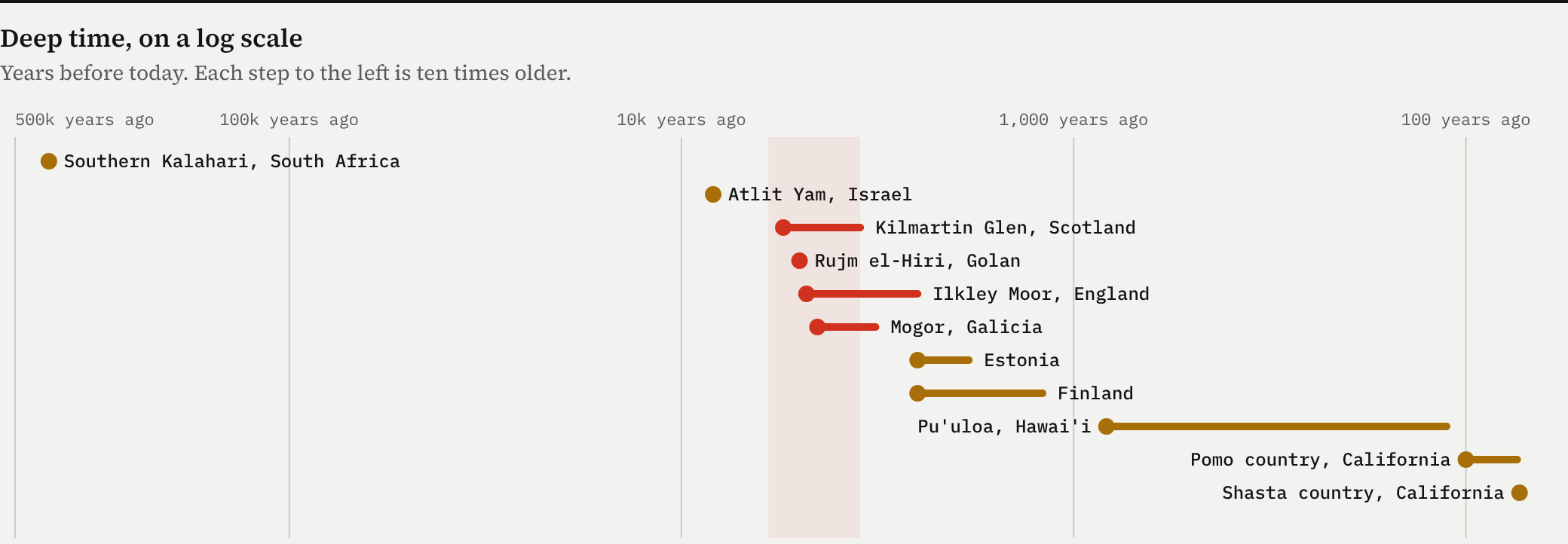
Wherever we actually know what cups meant, because someone wrote it down, the meanings are local and practical. In 1914 Hawaiian families still placed a newborn’s umbilical cord in a hole at Pu’uloa for long life; 84% of its 23,000 petroglyphs are cupules or holes. Pomo women in California pecked “baby rocks” when they wanted to conceive. Shasta people made “rain rocks”. In Estonia and Finland almost all cup stones sit in farmland. The shape is shared; the meaning is not.
What did they mean?
Archaeologists have argued about this for two centuries; one review lists 71 suggested meanings for cupules. These are the main theories for the Atlantic carvings.
- Water and rain. Gutters at Hunterheugh in Northumberland seem to lead rainwater from cup to cup. But many rings have no gutter, and many panels are on near-flat rock.
- Markers on routes and views (widely held). Richard Bradley argued that carvings cluster where routes enter upland grazing and where there are wide views; on Ilkley Moor complex carvings sit at about 250 to 400 metres. It explains where, not what.
- Close to the sea (new test). In this post’s data, Irish, Scottish and Galician carvings sit far closer to the coast than random land, matching a motif carried by boat. England’s moorland group is the exception.
- Stone, axe and metal sources (possible). Some carvings sit near outcrops used for polished stone axes, such as Great Langdale, and Galician weapon carvings tie part of the art to the Bronze Age metal trade. Most panels are nowhere near a known source.
- Trance and vision (plausible origin). Concentric rings are a form the visual cortex produces on its own. That explains why the shape is universal, not why it was carved on these rocks at this time.
- Stars, maps or writing (weak). Thom thought the marks encoded a system and a unit; others see star maps or landscape maps. Tests of the unit found weak evidence, and no map reading has been confirmed independently.
- Birth, death and ownership (elsewhere, yes). Where meanings were written down, cups marked births, fertility, deaths and property. These are other cultures; they show meanings are local, not what the Atlantic carvers meant.
My reading
Putting the data together, I think the cup-and-ring is best understood as three layers stacked on top of each other.
1. A human shape. The cup is the simplest mark a hammer stone makes, and the ring is the simplest shape a cord makes. The visual system finds both compelling. That is why they appear across the world, independently, from the Palaeolithic onwards.
2. An Atlantic grammar. The particular combination of cup, rings and gutter, carved on open bedrock, belongs to the Atlantic seaboard from about 4000 BC. It sits close to the sea in Ireland, Scotland and Galicia, which fits a motif spread by sea along the routes the first farmers used.
3. Local meanings. The meaning was rewritten by each community that inherited it. The carvings carried on through the Beaker turnover in Britain and flourished in Galicia after the steppe arrival. People kept the places and the sign while their ancestry changed.
This reading makes predictions that better data could test. If the grammar travelled by sea, the earliest securely dated ringed rocks in each region should sit nearest the coast, and inland groups like Ilkley should be younger. If rings were about places, they should favour fixed bedrock over portable stones everywhere, not just in Scotland. And if meanings were local, the details (gutter direction, number of rings, what sits next to the carvings) should vary more between regions than within them.
What it does not support is the idea of a single “Atlantic people” with a single message. The DNA shows the people changed. The rings stayed.
Notes and sources
- Scotland: Historic Environment Scotland, Canmore, queried in October 2026 for cup-marked, cup-and-ring and prehistoric carved rocks; later periods excluded, leaving 2,845 records (143 “possible”). Known panels and motif counts: Scotland’s Rock Art Project, Heritage Science 2024. Dating: ScRAP on dating; Kilmartin Museum on Torbhlaren.
- Ireland: National Monuments Service prehistoric rock-art layer (950 records; 68 moved stones and 56 with a placeholder location dropped); dating summary.
- England and Wales: Wikidata; Ilkley: Historic England list entry 1012012; England’s Rock Art.
- Galicia, Portugal and Brittany: Wikidata and OpenStreetMap petroglyph features, duplicates within 150 m merged. Motif counts: Rodríguez Rellán, Vázquez Martínez and Fábregas Valcarce, Trabajos de Prehistoria 75(1), 2018. Mogor: Prehistour. Dating debate: Adoranten.
- Ancient DNA: Brace and others 2019; Cassidy and others 2016; Olalde and others 2018; Olalde and others 2019.
- World sites: Cup and ring mark; Rock cupule; Daraki-Chattan cupule project; US National Park Service on Pu’uloa; San Diego Archaeological Center on California cupules; Folklore vol. 11 on Estonian and Finnish cup stones.
- Vision: form constants (Klüver 1926; Ermentrout and Cowan 1979; Bressloff and others 2002); Lewis-Williams and Dowson 1988.
- Coast test: distance to the Natural Earth 1:10m coastline in an equal-area projection, against 4,000 random land points per region. Ripple model: linear gravity-capillary waves, g = 9.81 m/s², σ/ρ = 7.3×10⁻⁵ m³/s².

