
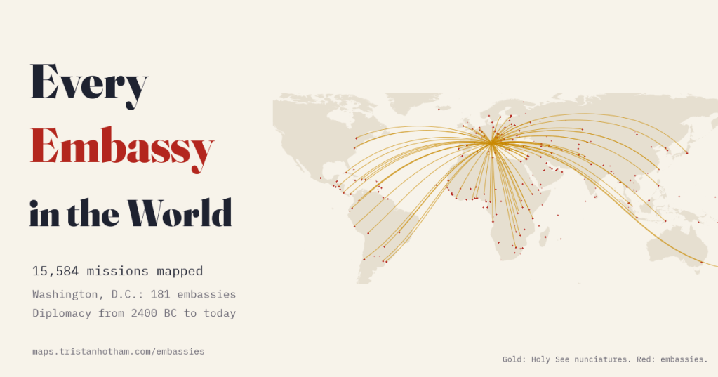
Every country keeps a small piece of itself in other people’s capitals. I mapped 15,584 embassies, consulates and other missions from open data, drew every country’s network, and followed the diplomatic web back from today to the clay letters of Amarna.
An embassy is an odd thing when you think about it. A few buildings in a foreign city, flying another country’s flag, staffed by people who answer to a government thousands of kilometres away. Put all of them on one map and you get something like a portrait of how states see each other: who bothers to be present, who shares a street, and who is never in the same room.
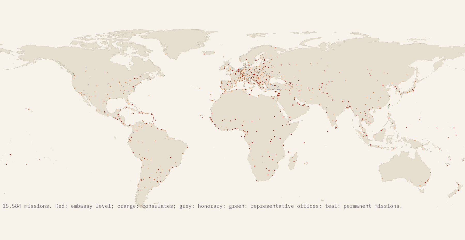
There is no official list of every embassy in the world, but there is open data. OpenStreetMap volunteers have mapped 17,573 diplomatic buildings, and Wikidata lists thousands of embassies by who sends them and who receives them. I cleaned, merged and checked the two. The result is 15,584 current missions sent by 198 states: 8,917 embassies, 406 high commissions, 92 papal nunciatures, 1,857 consulates-general, 1,867 honorary consulates and more.
Who is everywhere
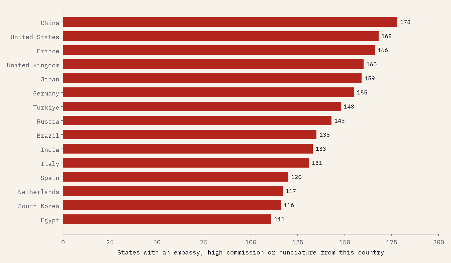
Counting embassy-level missions, China is present in more states than anyone else, 178, just ahead of the United States (168) and France (166). Count every post, consulates included, and the United States edges ahead with 279. I was worried that open data would be patchy, so I checked: for the seven countries whose totals the Lowy Institute published from its 2024 Global Diplomacy Index, this map finds between 85% and 105% of Lowy’s number. That is far better than I expected from volunteers.
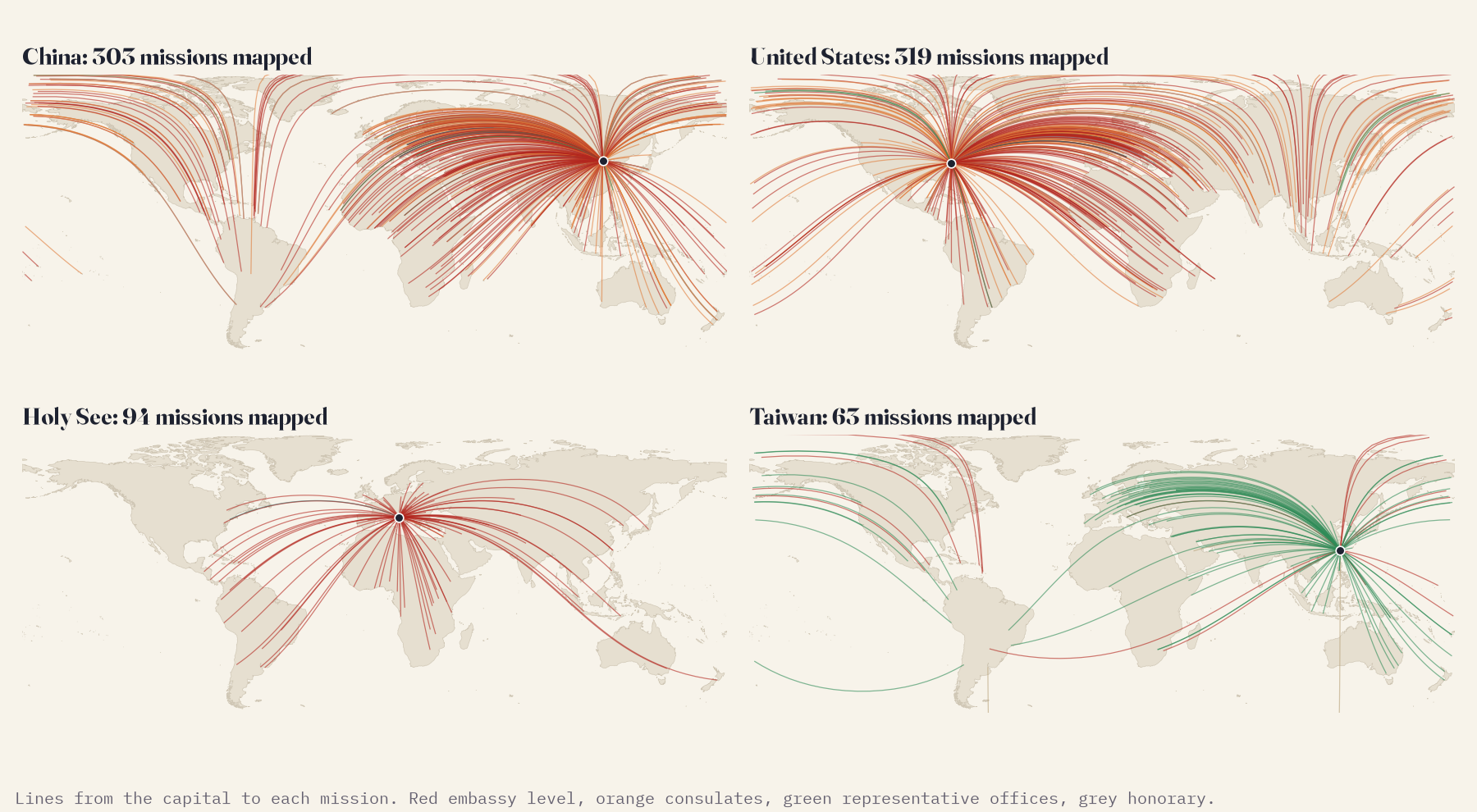
The small players are the fun ones. The Holy See, a state of about 825 people, has 88 nunciatures, a bigger network than most countries. San Marino has 11 embassies and Tuvalu, with about 11,646 people, 4. Taiwan has embassies in the 12 states that recognise it and works everywhere else through 52 mapped representative offices, which is why its network looks like a fan of green lines in the picture below.
Capitals, and the ones embassies never followed
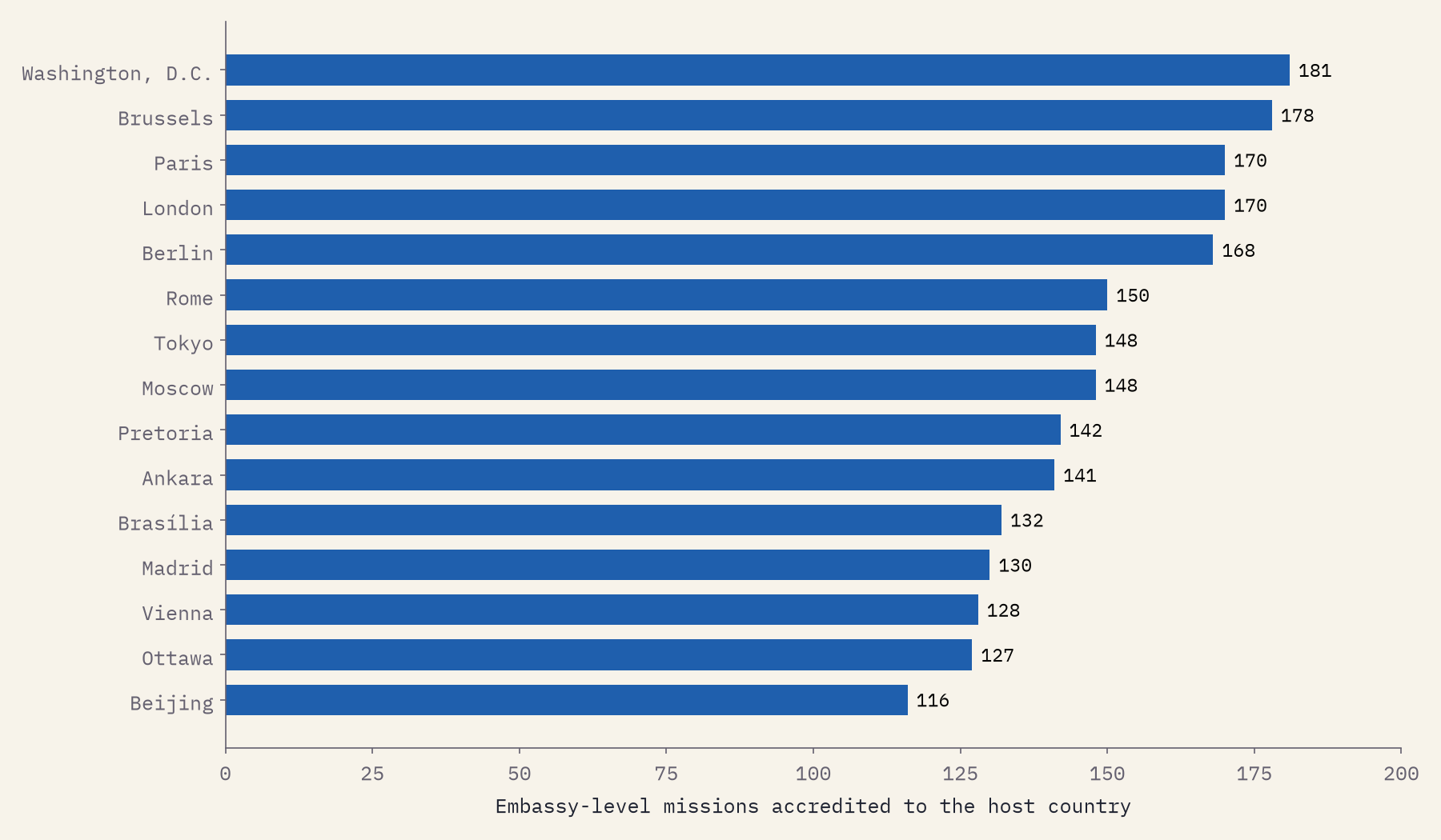
Washington, D.C. hosts 181 embassies, the most of any city; Brussels has 178, then Paris and London with 170 each. Consulates follow money and people rather than governments: Barcelona has the most career consulates of any city (83), ahead of Istanbul. And the densest square kilometre on Earth is around United Nations headquarters in New York, with 182 missions within a kilometre of one point.
Bolivia’s constitutional capital is Sucre. All 33 mapped embassies are in La Paz.
Embassies are expensive to move, and some never follow a new capital. Tanzania’s 61 mapped embassies are in Dar es Salaam, not Dodoma; Cote d’Ivoire’s 42 in Abidjan, not Yamoussoukro; Myanmar’s 46 in Yangon, not Naypyidaw. Of 82 embassies to Israel, 79 are in the Tel Aviv area and 3 in Jerusalem, whose status is disputed. Where a move did work, the consulates stay behind: Lagos keeps 24 consulates while 74 embassies sit in Abuja, and Switzerland splits neatly into 85 embassies in Bern and 58 missions to international organisations in Geneva. Liechtenstein, meanwhile, hosts no resident embassy at all.
From Amarna to today
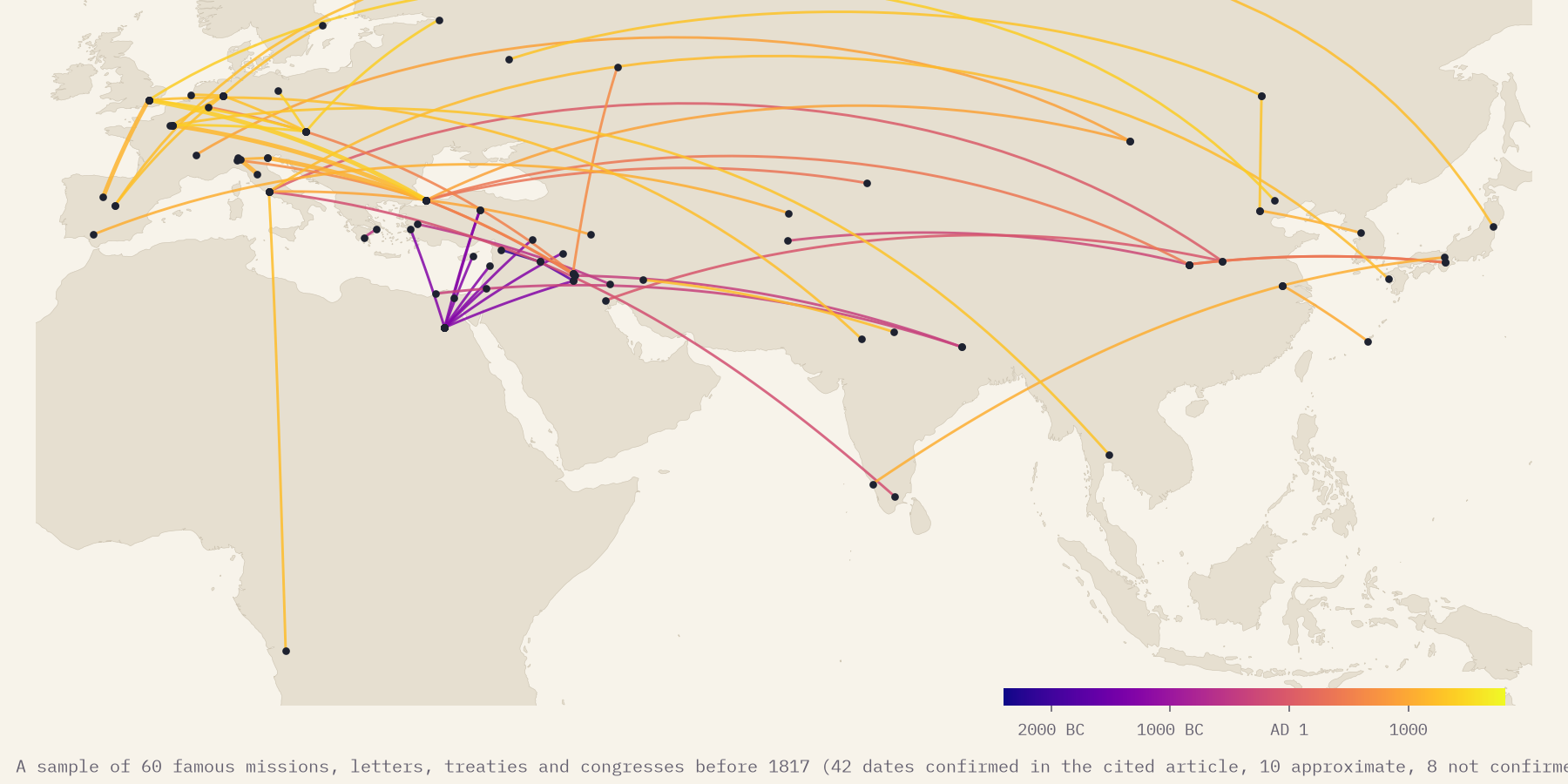
Diplomacy is very old; the embassy that stays is not. Around 1350 BC the pharaoh’s court at Amarna exchanged letters, envoys and gifts with the kings of Babylon, Mitanni, Hatti and Assyria. For three thousand years most envoys came, talked and went home. Resident ambassadors appear in Renaissance Italy in the 1440s and 1450s; the Ottoman Empire opened its first permanent embassy, in London, only in 1793. The interactive timeline plays a small sample of 52 famous missions before handing over to the Correlates of War data, which record which states were represented in which from 1817 to 2005. A caution: that early sample is a handful of famous cases, not a census. I checked each date against the article I cite for it: 42 lines are confirmed, 10 approximate and 8 not confirmed, and the map shows which is which.
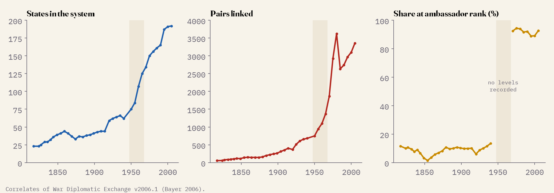
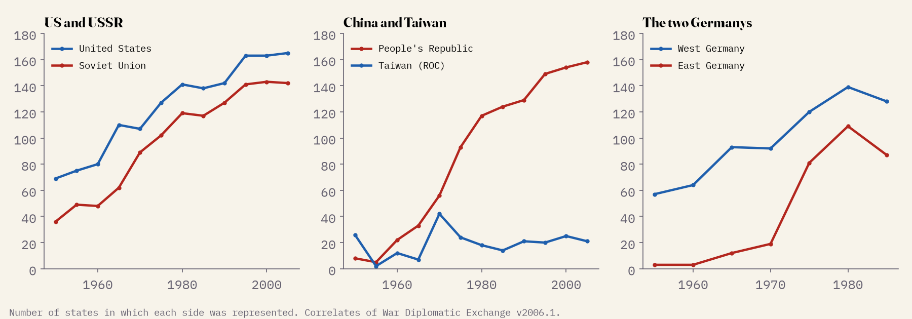
In 1817 the system had 23 states, and only 23 of 198 links were at the rank of ambassador, a great power’s privilege; the Kingdom of the Two Sicilies hosted almost as many envoys as London. By 2005 there were 192 states and 93% of links were ambassadors. The waves of new states after 1918, 1960 and 1991 stand out, and so do the Cold War’s rival networks: in 1965 West Germany was represented in 93 states and East Germany in 12; ten years later, after the two recognised each other, the East had 81.
How I did this
I took every OpenStreetMap object tagged as a diplomatic office, worked out which state sends it (from its tags, its linked Wikidata item or its name, in English and 22 other languages) and which receives it, and dropped residences, offices of international organisations and things that were not diplomatic at all. I merged duplicates and matched the result with Wikidata’s embassies, consulates and representative offices. Two of the Wikidata classes I had downloaded turned out to be schools and television channels, so they went. Records of Taiwanese embassies in states that have since switched recognition were flagged as out of date. For every country I compared its 2026 network with what the Correlates of War data recorded in 2005, which gives a rough coverage check; the network abroad looks complete for 185 of 190 countries. The caveats matter: a dot is a mapped mission, not proof that it is open today; consulates and honorary consulates are mapped very unevenly; and where recognition is contested, the map records what the data say and takes no side.
Notes and sources
- Missions: © OpenStreetMap contributors (ODbL 1.0) and Wikidata (CC0); the merged gazetteer is released under the ODbL.
- Bayer, Resat (2006) Diplomatic Exchange Data set, v2006.1. Correlates of War Project.
- Lowy Institute Global Diplomacy Index 2024 (totals quoted for comparison); Natural Earth (public domain).
- Deep history: a sample of famous missions, each citing an English Wikipedia article (CC BY-SA 4.0); 42 dates confirmed in the article, 10 approximate, 8 not confirmed.
- I wrote the text, with drafting and editing assistance from Claude (Anthropic), which also helped prepare the analysis code. I reviewed and checked all text and results.

