
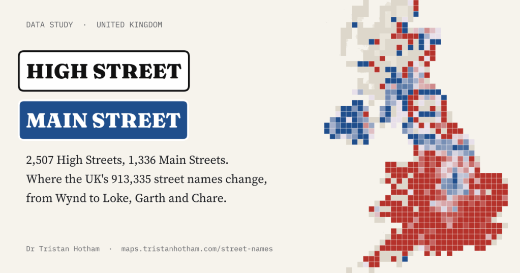
Is the main street where you live a High Street or a Main Street? I sorted all 913,335 named streets in the UK by name to find where one gives way to the other, and found a divide that runs less between north and south than between town and village.
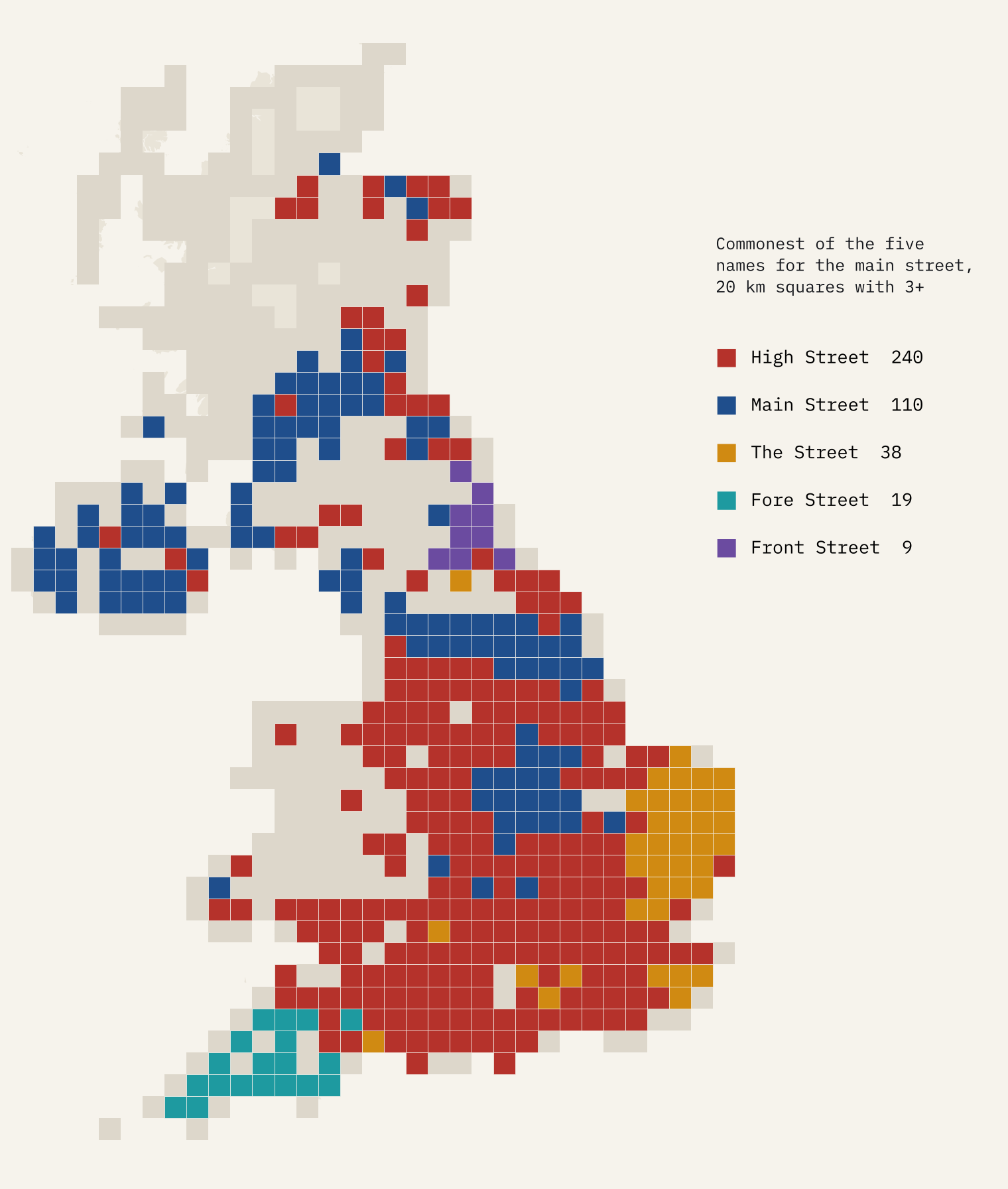
Drive north from London and at some point the High Street becomes a Main Street. Everyone who has spent time in Scotland or Northern Ireland knows it, but where exactly does it happen? Ordnance Survey publishes the name and position of every named road in Great Britain as open data, and OpenStreetMap’s volunteers have mapped the streets of Northern Ireland, so the line no longer needs to be guessed.
I took all 913,335 named streets, 884,116 in Great Britain and 29,219 in Northern Ireland, and counted them by name, by the word at the end (Road, Lane, Close, Wynd) and by the word at the start (Heol, Back, Church). High Street is the commonest street name in the UK, with 2,507. Main Street is sixth, with 1,336, behind Station Road, Church Lane, Church Street and Mill Lane.
Not quite north and south
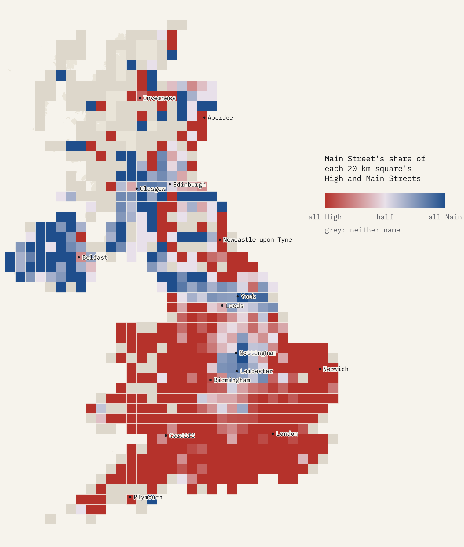
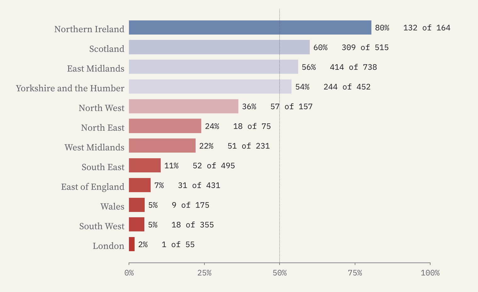
The broad pattern is the expected one. England has 2,103 High Streets and 886 Main Streets, Wales 166 and 9. Scotland turns it round, with 309 Main Streets to 206 High Streets, and Northern Ireland has 132 to 32.
But look at England more closely and the line wobbles. London has 54 High Streets and one Main Street. The North East, right next to Scotland, has only 18 Main Streets. Meanwhile the East Midlands has more Main Streets than High Streets (414 to 324), and so does Yorkshire and the Humber (244 to 208). 33 of England’s 296 councils have more Main Streets than High Streets, led by North Yorkshire, the East Riding, Harborough and Melton.
A village word
Ordnance Survey records the town or village each street belongs to, so I could ask whether size matters. It does, more than anything else I tried. In England’s towns, Main Street makes up 8% of the pair. In England’s villages it is 38%. In the East Midlands and Yorkshire it is 13% in towns and 62% in villages, and even in Scotland the towns lean to High Street (27% Main) while the villages do not (78%).
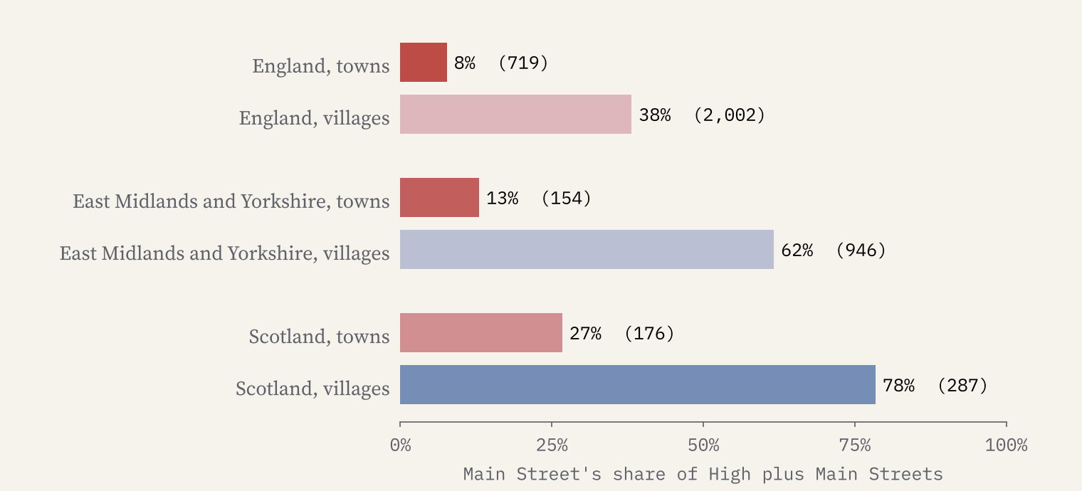
High Street is a town name. Main Street, across the Midlands, the north and Scotland, is a village name.
That fits the plain meaning of the words. “High” in High Street meant chief or principal, and the name belonged to the main street of a market town; a village’s one street was simply its main street. The map shows where each name is today, though, not when it was given, so I would not push that story too hard.
The Street, Fore Street, Front Street
High and Main are not the only names for the main street. The Street (606) is 86% in the East of England and the South East, with 46 in North Norfolk alone. Fore Street (181) is 90% in the South West, 70 of them in Cornwall. Front Street (168) is 60% in the North East, 61 in County Durham. Give each 20 km square whichever of the five it has most of, and the country falls into clean blocks.
Wynds, lokes, twittens and garths
Most streets end in a handful of words: Road ends 19% of names, Close 14%, Street 9%, Lane 8%. The rare endings are the fun ones, because so many belong to a single region. Wynd (981) is 89% Scottish, with 148 in Fife. Garth (883) is 75% in Yorkshire and the Humber. Brow (511) is 78% in the North West, with Ribble Valley and Chorley at the top. Chare (42) is found only in the North East. Loke (187) is 99% in the East of England, 52 of them in North Norfolk, and the rare Twitten (18) is a Sussex word.
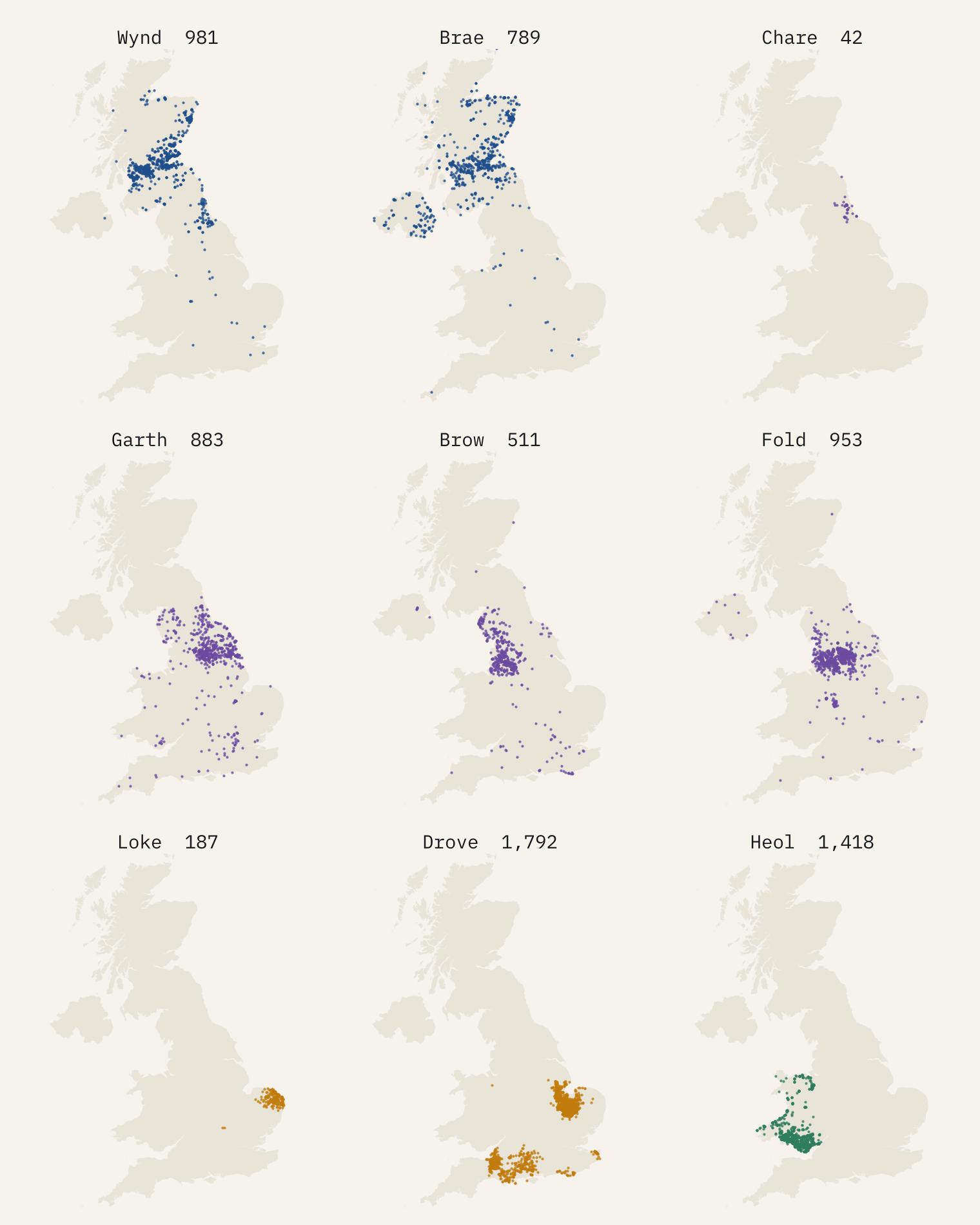
Some of these are history, some landscape and some building. Drove (1,792), a track for driving stock, clusters in the Fens and the Somerset Levels. Bolton has 667 street names beginning with Back, the named back streets behind its terraces. In Northern Ireland 11% of streets end in Park, against 0.7% in Great Britain: the housing estate is a Park there, where in England it would be a Close. In Wales, 22% of streets have a Welsh name or start with a Welsh street word, Heol most often.
Station Road and the king
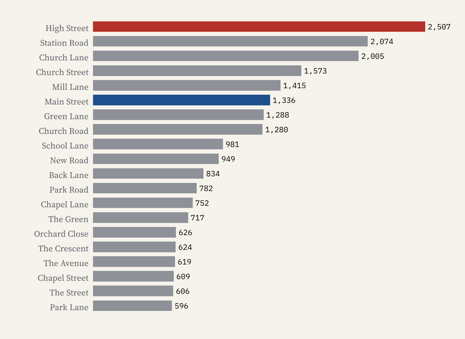
The UK’s streets share 388,197 different names, and 75% of those names belong to a single street, so your own street is probably more unusual than it feels. Royalty is everywhere, though: names with King number 2,735, Queen 2,378 and Victoria 2,032. On the interactive page you can type any street name and see where its namesakes are, map any of the street words, or go to your own town.
How I did this
For Great Britain I used the 884,116 features of type Named Road in Ordnance Survey’s OS Open Names, leaving out the extra points OS adds for sections of roads inside settlements. For Northern Ireland, which OS open data do not cover, I took 66,824 named road ways from OpenStreetMap and joined pieces of the same street, giving 29,219 streets. Names are counted exactly, so Upper High Street and High Road are not High Streets. Each street was placed in its current council area and on 10 km and 20 km squares, and matched to its Ordnance Survey town or village for the town and village comparison. The two sources divide streets differently, so compare shares rather than raw counts across the Irish Sea, and remember this is a map of today’s names, many given by developers and councils in the last century.
Notes and sources
- OS Open Names, Ordnance Survey. Contains OS data © Crown copyright and database right 2026, Open Government Licence v3.0.
- OpenStreetMap contributors, via the Overpass API. Open Database Licence 1.0.
- Local authority district boundaries, Office for National Statistics, via uk-topojson. Open Government Licence v3.0.
- The paper: Hotham, T. (2026) High Street or Main Street? The United Kingdom’s Street-Name Divide. Zenodo. https://doi.org/10.5281/zenodo.23757702
- Sister project: Beck, brook or burn?, the same idea for streams, valleys and hills.
- I wrote the text, with drafting and editing assistance from Claude (Anthropic), which also helped prepare the analysis code. I reviewed and checked all text and results.

