
Grimsby, Lancaster, Llandudno, Pitlochry, Ballymena: every place name is a small fossil of the language that named it. I tagged 105,532 town, village and townland names across Britain and Ireland by the old words inside them, and checked thousands of Irish spellings against their official Irish forms. Kil- turns out to mean wood far more often than you might think.
Bradford is the broad ford. Grimsby is a Norse farmstead. Lancaster is the Roman fort on the Lune, Llandudno the church of Saint Tudno, Ballymena the middle settlement. Most of us read these names every day without noticing that they are written in five or six languages: Old English, Old Norse, Latin, Welsh and Cornish, Pictish, and Gaelic.
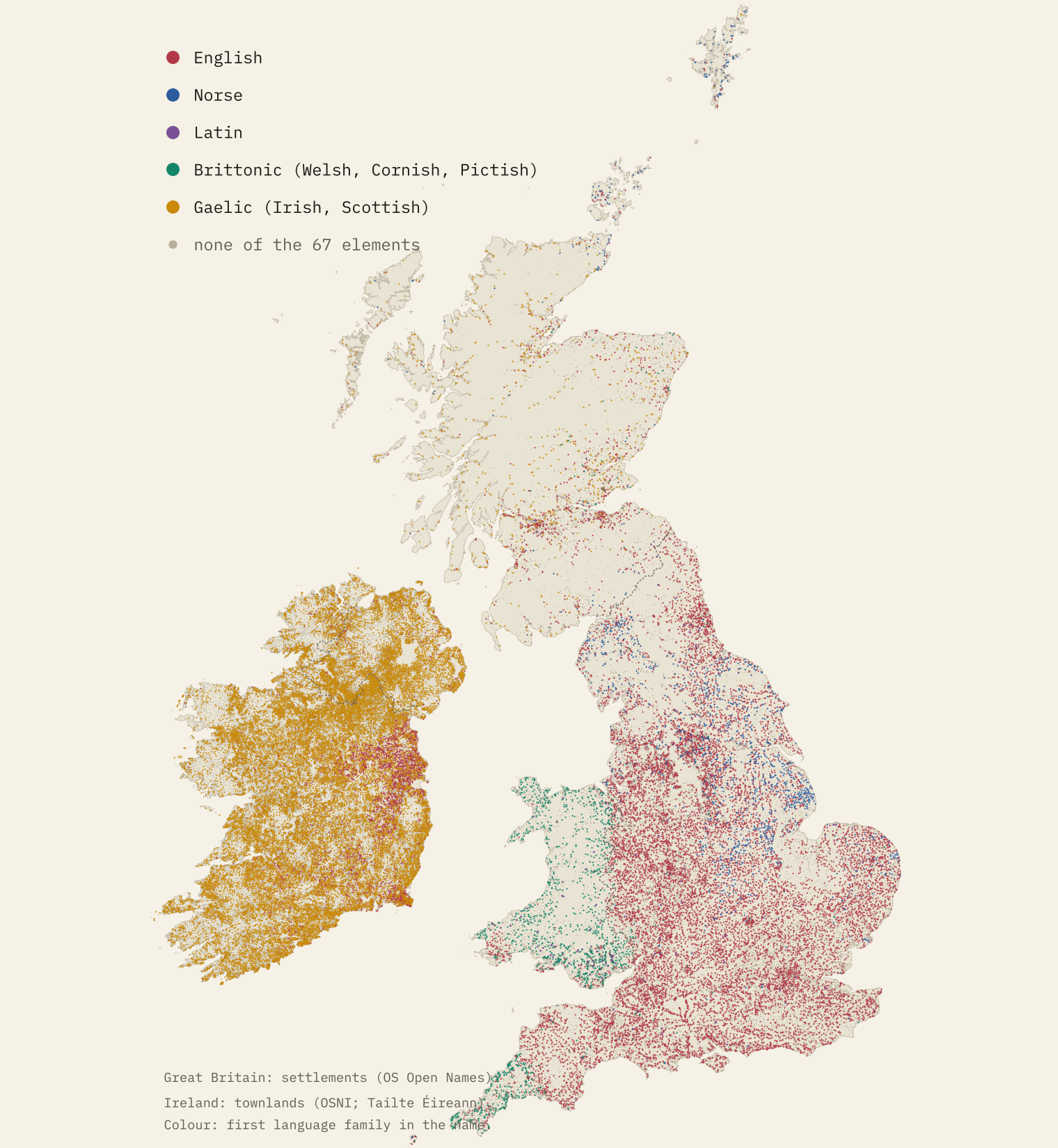
Place-name scholars have studied them for well over a century, county by county and name by name. I wanted the whole picture at once. So I took every settlement in Ordnance Survey’s open gazetteer of Great Britain, Northern Ireland’s official towns and townlands, and the Republic of Ireland’s official gazetteer of towns and townlands, and tagged each name with 67 spelling rules: endings such as -ton, -by and -chester, beginnings such as llan-, aber-, tre-, pit-, inver-, bally- and kil-. That is 45,632 settlements and 59,900 Irish townlands.
One caution before the findings. A spelling is not an etymology. My rules find letters, and the meanings I give are the usual readings; a single name needs a place-name dictionary. Treat each tag as a good first guess. In Ireland, as you will see, I could do better than guess.
Five languages, one map
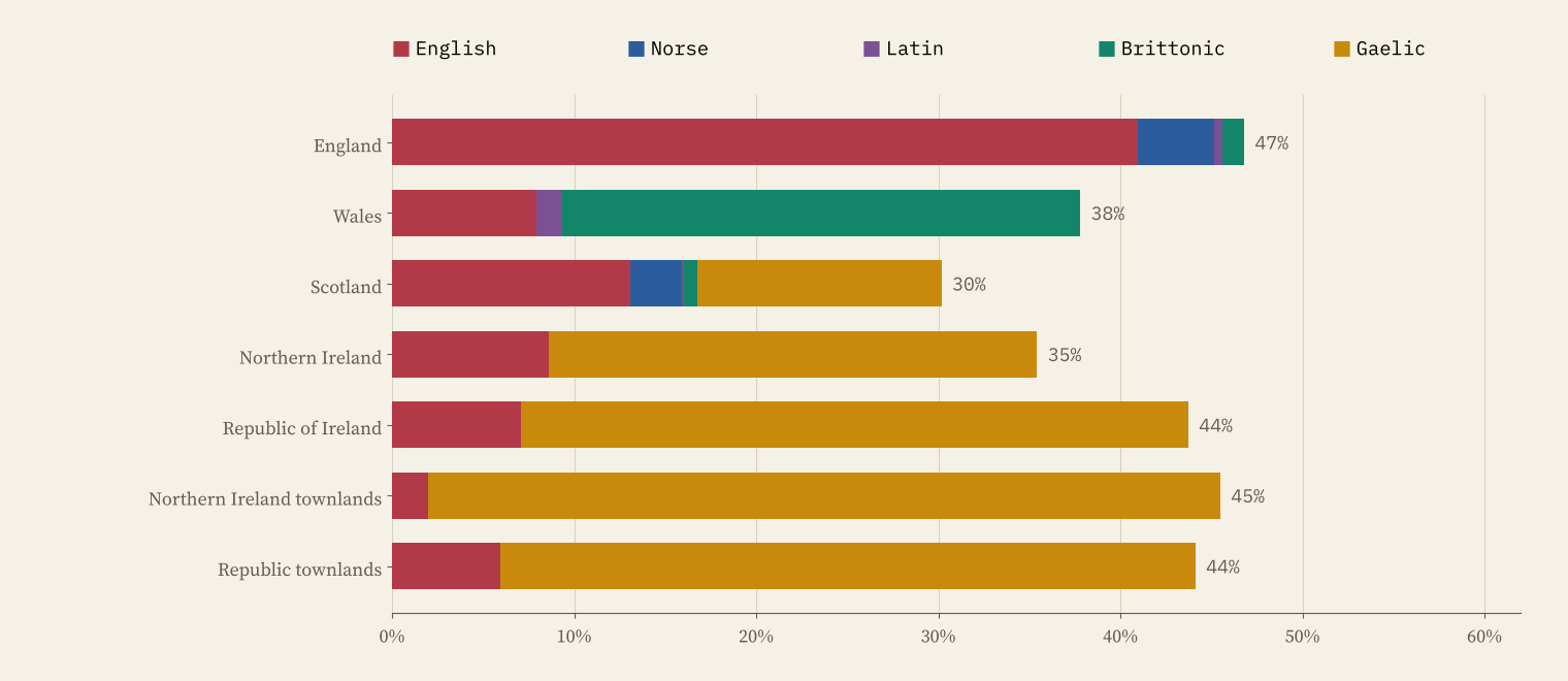
43% of settlements and 44% of townlands carry at least one element on my list. England is English: 41% of its settlements have an English element and 4.2% a Norse one. Wales is Welsh, 28% against 8% English. Scotland is the most mixed, with Gaelic and English elements level at about 13% each, and Norse names on 25% of Shetland’s settlements. In Ireland, Gaelic elements start 38% of townland names in the Republic and 44% in Northern Ireland.
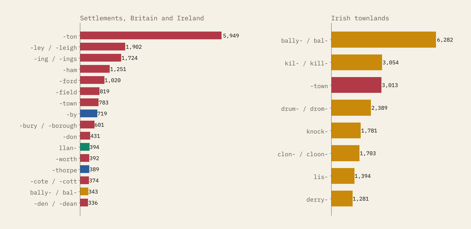
The single commonest element is the Old English tūn, a farmstead or estate that grew into a village: 5,949 settlements end in -ton, 16% of all those in England. Then come -ley, a woodland clearing (1,902), -ing (1,724) and -ham (1,251). Among Irish townlands, Bally- leads by a distance with 6,282, then Kil- (3,054) and, surprisingly, the English -town (3,013).
Some elements are town words. The Old English ceaster, borrowed from Latin castra and used for Roman forts and towns, survives in 67 settlement names, and 33% of them are towns or cities (Manchester, Lancaster, Doncaster, Chester), against 3.3% of all settlements in Great Britain. Others are hamlet words: 50% of tre- names in Wales and Cornwall are hamlets.
How sharp is the Welsh border?
Language borders on maps are usually drawn as lines, but are they? I measured every settlement’s distance from the land border between England and Wales and applied the Welsh rules (llan-, pen-, aber-, tre-, cwm, bryn, nant and the rest) on both sides.
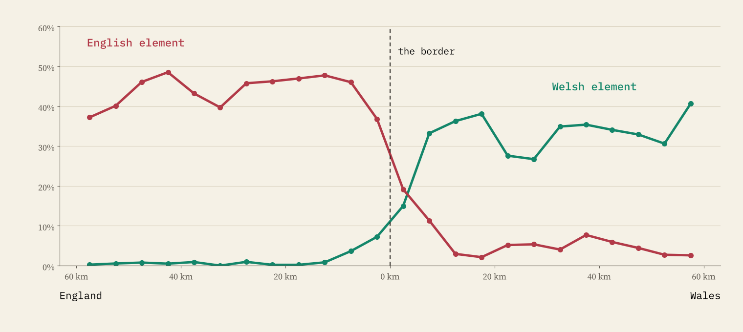
It is sharp. Between 20 and 40 km inside Wales, 31% of settlements have a Welsh element; at the same distance inside England, 0.5%. But the line is not a cliff. 73 English settlements near the border have Welsh spellings, from Llanyblodwel and Llanfair Waterdine in Shropshire to Pontrilas and Llangrove in Herefordshire, and English names reach into Wales the other way.
Tre, Pol and Pen
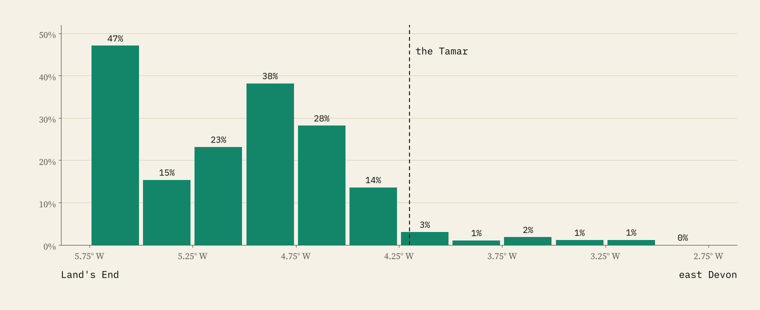
“By Tre, Pol and Pen shall ye know the Cornishmen”, goes the rhyme, and the data agree. With the Cornish rules run in both counties, 27% of Cornwall’s settlements carry a Cornish element and 1.4% of Devon’s, most of those false friends such as Rosemary Lane. There are 183 tre- settlements in Cornwall and 1 in Devon. The share barely falls across Cornwall, then stops at the Tamar.
Aber or inver?
Scotland has two words for a river mouth. Aber- is Brittonic, from the Britons and the Picts; inver- is Gaelic. On my count there are 22 aber- settlements in Scotland and 54 inver- ones, and 20 of the abers lie east of 4 degrees west, in Perth and Kinross, Fife and Aberdeenshire. The Picts’ pit-, a share of land, survives in 25 settlement names, all but a few in the east: Pitlochry, Pittenweem, Pitmedden.
Ireland: when Kil- means wood
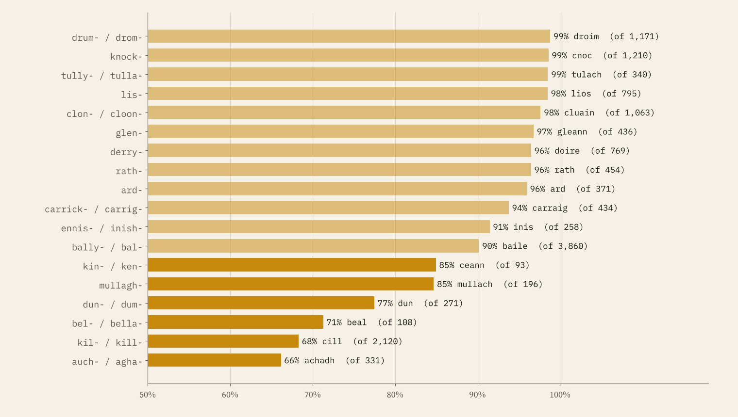
Ireland’s names live in its townlands, about 59,900 small land units. In the Republic, the official gazetteer gives an Irish form for 35,223 of them, which lets me check what an English spelling actually stands for. Most beginnings are what they seem: Knock- is cnoc, a hill, 99% of the time, Drum- is droim, a ridge, 99%, and Bally- is baile, a settlement, 90%. Even there, 184 Bally- names are Béal, the mouth of a ford, as in Ballina, Béal an Átha.
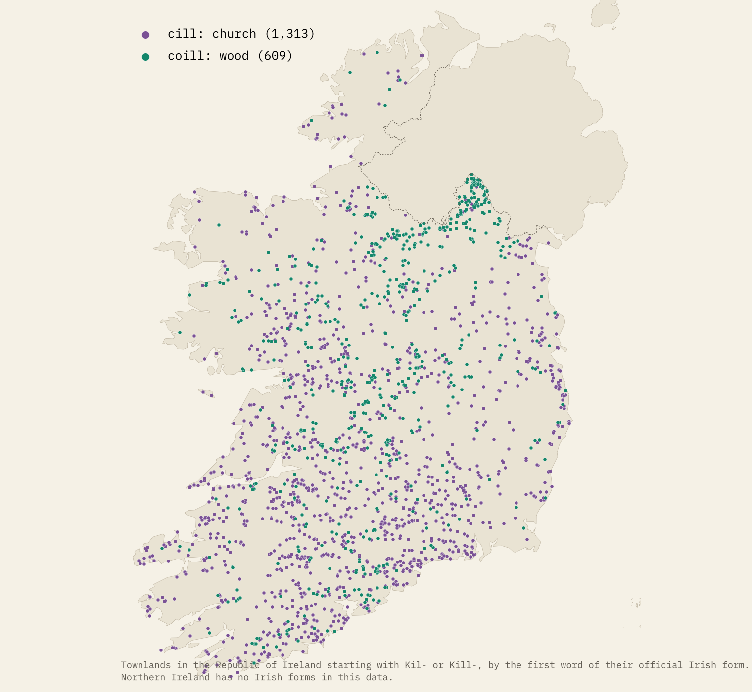
Kil- is the big exception. It is usually explained as cill, a church or monastic cell, and many Kil- names are just that. But of 2,120 Kil- names with an official Irish form, 629 (30%) are coill, a wood. And the wood names cluster: in Monaghan, 95 of 105 Kil- townlands are coill; in Kilkenny, 7 of 78.
In Monaghan, a Kil- townland is a wood nine times in ten, not a church.
Bally- has its own geography. In Ards and North Down 48% of townlands start with Bally-, in Wexford 21%, but in Leitrim, Monaghan, Cavan and Fermanagh and Omagh under 2% do; their townlands are Drums, Kils, Lisses and Derrys. And in Meath 35% of townlands end in the English -town, as do 26% in Dublin and 25% in Kildare: the map still shows the English-speaking Pale of the Middle Ages.
How I did this
The names come from OS Open Names (all 43,274 populated places in Great Britain), OSNI Open Data (336 towns and villages and 9,520 townlands in Northern Ireland) and Tailte Éireann’s National Placenames Gazetteer (2,022 towns and villages and 50,380 townlands in the Republic, with official Irish forms). Each name is split into words, qualifiers such as Upper and Little are dropped, and each word is tested against the rules. Some rules only run where the language was spoken, so Balham and Kilburn in London are not counted as Gaelic. A random sample of 280 matches was read through for obvious false friends during the analysis; 9 turned up, such as Tucking Mill caught by -ing.
The limits matter. The datasets differ (Britain’s goes down to hamlets, the Irish town lists only to larger places, which is why the townlands are there), modern spellings can hide or fake an element, and nothing here dates a name. On the map you can look up any town, village or townland and see which elements its name carries and what they usually mean. My earlier study Beck, brook or burn? covers the Norse line and the Danelaw in more detail.
Notes and sources
- OS Open Names, Ordnance Survey. Contains OS data © Crown copyright and database right 2026, Open Government Licence v3.0.
- OSNI Open Data Gazetteer Place Names and Largescale Boundaries Townlands, Land and Property Services. Contains public sector information licensed under the Open Government Licence v3.0.
- National Placenames Gazetteer, Centres of Population and Townlands, © Tailte Éireann, CC BY 4.0.
- Local authority district boundaries, Office for National Statistics, Open Government Licence v3.0; Natural Earth (public domain).
- The paper: Hotham, T. (2026) What Is Your Town’s Name Made Of? A Spelling-Based Atlas of Place-Name Elements in Britain and Ireland. Zenodo. https://doi.org/10.5281/zenodo.23761433
- Related: Beck, brook or burn?, Bloody place names and High Street or Main Street?
- I wrote the text, with drafting and editing assistance from Claude (Anthropic), which also helped prepare the analysis code. I reviewed and checked all text and results.

